Location
Latitude: |
33-55-50.9360N (33.930816) |
Longitude: |
078-04-24.1090W (-78.073364) |
Elevation: |
26.0 feet MSL (8 m MSL) |
Magnetic Variation: |
9.4 W (as of April 2024 from WMM2020 model) |
Time Zone: |
UTC -5.0 (Standard Time) UTC -4.0 (Daylight Savings Time) |
From City: |
01 N.M. NE of Oak Island, North Carolina |
Found On: |
Charlotte Chart |
FAA Region: |
ASO |
Contacts
Manager: |
Publicly owned: |
| HOWARD FRANKLIN 4015 AIRPORT ROAD SOUTHPORT, NC 28465 910-457-6483 |
BRUNSWICK CO ARPT COMMISSION 4019 LONG BEACH ROAD OAK ISLAND, NC 28461 910-457-6534 |
Operations
Airport Status: |
Operational |
Facility Use: |
Public |
Type: |
Airport |
Control tower: |
No |
Attendance (Months/Days/Hours): |
Months/Days/Hours ALL/ALL/0800-1800 |
Boundary ARTCC: |
ZDC (Washington) |
Responsible ARTCC: |
ZDC (Washington) |
Lighting Schedule: |
SEE RMK |
Segmented Circle Indicator: |
Yes |
Traffic Pattern Altitude (MSL): |
1026 feet (313 m) |
NOTAMs Facility: |
SUT |
NOTAM-D Service: |
Yes |
International Airport of Entry: |
No |
Customs Landing Rights: |
No |
Military Landing Rights: |
Yes |
Civil/Military Joint Use: |
No |
Based Aircraft
| Single Engine: | 63 |
| Multi Engine: | 9 |
| Jet Engine: | 2 |
| GA Helicopters: | 2 |
| Gliders: | 1 |
Annual Operations (as of 08/19/2023)
| Total Operations: | 77000 | |
| GA Local: | 30000 | 39.0% |
| GA Itinerant: | 44000 | 57.1% |
| Military Aircraft: | 3000 | 3.9% |
Communications
| CTAF: | 123.050 |
| Unicom: | 123.050 |
| Approach: | WILMINGTON 118.25 118.25 WASHINGTON ARTCC |
| Departure: | WILMINGTON 118.25 118.25 WASHINGTON ARTCC |
| AWOS-3P: | 124.175 (910-457-1710) |
- APCH/DEP SVC PRVDD BY WASHINGTON ARTCC ON FREQS 124.025/269.15 (WILMINGTON RCAG) WHEN WILMINGTON APCH CTL CLSD.
Fixed Based Operators (FBOs) & Fuel
(Click on a business for detail)
Please help us keep this information up to date. This is a FREE SERVICE just like everything else on Airport Guide! If you see that a business needs to be added, modified, or deleted please fill out our Update Form.
To add, modify, or delete a business click here.
Please help us keep this information up to date. This is a FREE SERVICE just like everything else on Airport Guide! If you see that a business needs to be added, modified, or deleted please fill out our Update Form.
Area Code: 910 |
| Business Name | Frequency | Phone | Fuel Grade |
|---|
Flight Service Stations
| Primary | Alternate | |
| FSS on Field: | N | |
| FSS Name (ID): | Raleigh(RDU) | |
| Frequency: | ||
| Toll Free Phone: | 1-800-WX-BRIEF |
Instrument Procedures / Charts
FAA Terminal Procedures valid from 0901Z 03/21/24 to 0901Z 04/18/24.
There are various types of charts available for an airport. They are listed in the Page Type column. Here is a legend for those types:
APD - Airport Diagram
DP - Departure Procedure Charts
HOT - Hot Spots
IAP - Instrument Approach Procedure Charts
MIN - Minimums
STAR - Standard Terminal Arrival Charts
| Page Type | Page Name | Volume | Action Since Last Cycle |
|---|---|---|---|
| IAP | RNAV (GPS) RWY 05 | SE-2 | |
| IAP | RNAV (GPS) RWY 23 | SE-2 | |
| MIN | ALTERNATE MINIMUMS | SE-2 | |
| MIN | TAKEOFF MINIMUMS | SE-2 |
Terminal Procedures are only available for airports in several countries with more being added all the time. If you are looking for a specific country's charts, please send an email to support(at)airportguide.com stating the country name. This will be used to prioritize the implementation.
Navigation Aids (Navaids) near KSUT
| Dist (NM) | ID | Morse Code | Name | Type | Freq | True Hdg | Mag Hdg |
|---|---|---|---|---|---|---|---|
| 11.9 | CLB | _ . _ . . _ . . _ . . . | Carolina Beach | NDB | 216 | 27 | 36 |
| 18.7 | IL | . . . _ . . | Airli | NDB | 281 | 33 | 43 |
| 27.1 | ILM | . . . _ . . _ _ | Wilmington | VORTAC | 117.00 | 21 | 31 |
| 27.6 | GM | _ _ . _ _ | Wilze | NDB | 205 | 27 | 37 |
| 33.2 | CRE | _ . _ . . _ . . | Grand Strand | VORTAC | 114.40 | 257 | 266 |
| 37.8 | CPC | _ . _ . . _ _ . _ . _ . | Camp | NDB | 227 | 303 | 312 |
| 42.1 | TGQ | _ _ _ . _ _ . _ | Elizabethtown | NDB | 398 | 328 | 337 |
| 49.1 | DIW | _ . . . . . _ _ | Dixon | NDB | 198 | 38 | 48 |
| 52.5 | OA | _ _ _ . _ | Ellas | NDB | 261 | 20 | 30 |
| 52.9 | HYW | . . . . _ . _ _ . _ _ | Horry | NDB | 370 | 263 | 272 |
| 56.2 | NCA | _ . _ . _ . . _ | New River | TACAN | 115.40 | 33 | 43 |
| 63.5 | LBT | . _ . . _ . . . _ | Lumberton | VOR | 110.00 | 310 | 319 |
| 63.9 | RSY | . _ . . . . _ . _ _ | Robeson | NDB | 359 | 310 | 319 |
| 64.3 | CTZ | _ . _ . _ _ _ . . | Clinton | NDB | 412 | 347 | 356 |
| 64.4 | JB | . _ _ _ _ . . . | Jigel | NDB | 384 | 305 | 314 |
| 64.5 | MAO | _ _ . _ _ _ _ | Marion | NDB | 388 | 284 | 293 |
| 68.9 | DKA | _ . . _ . _ . _ | Kenan | NDB | 332 | 6 | 16 |
| 71.4 | DLC | _ . . . _ . . _ . _ . | Dillon | NDB | 274 | 296 | 305 |
| 72.6 | GGE | _ _ . _ _ . . | Georgetown | NDB | 242 | 239 | 248 |
| 73.4 | HEK | . . . . . _ . _ | Stuckey | NDB | 236 | 260 | 269 |
Nearby Airports with Fuel
Notices to Airmen (NOTAMS)
Remarks
| A110-1 | DEER AND BIRDS ON AND INVOF ARPT. |
| A110-2 | 4 FT DITCH 125 FT EACH SIDE RWY 05/23. |
| A110-4 | ARPT PHONE 910-457-6483. |
| A110-6 | FLT TRNG & SIGHTSEEING OPNS INVOF ARPT. |
| A110-7 | SKYDIVING OPNS. |
| A110-8 | HEL FLT TRNG AND SIGHTSEEING TOUR OPNS INVOF ARPT. |
| A110-9 | FOR CD CTC WILMINGTON APCH AT 910-815-4676, OR WHEN APCH CLSD CTC WASHINGTON ARTCC AT 703-771-3587. |
| A17 | FOR SVC AFTER HRS CALL 910-540-0957. |
| A57-23 | APCH RATIO 34:1 TO DSPLCD THR DUE TO 46 FT TREES 1782 FT FM DSPLCD THR OFFSET 330 FT RIGHT OF CNTRLN. |
| A70-FUEL-A1 | + FUEL AVBL 24 HR SELF SVC WITH CREDIT CARD. |
| A76 | FULL FLT SCHOOL. |
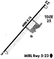
| A81-APT | ACTVT PAPI RWY 05 & 23; MIRL RWY 05/23 - CTAF. |
Runways
Runway Summary
| Runways: | 05/23 |
| Longest Runway: | 05/23 is 5505 ft (1678 m) long |
| Runways with an Instrument Approach: |
KSUT Airport Runway Details
| Runway 05/23 | 5505 ft x 100 ft (1678 m x 30 m) | |
| Runway Length Source: | 3RD PARTY SURVEY as of 06/14/2019 | |
| Surface: | Asphalt - Excellent condition - No special surface treatment | |
| Runway Edge Lights: | Medium Intensity | |
Runway Weight Bearing Capacity (in thousands of pounds) |
||
| Single Wheel Landing Gear: | 60.0 | |
| Dual Wheel Landing Gear: | 80.0 | |
Runway 05 |
Runway 23 |
|
Elevation: |
18.9 | 26.0 |
Latitude: |
33-55-30.3980N | 33-56-11.4730N |
Longitude: |
078-04-45.5556W | 078-04-02.6603W |
|
Runway True Alignment: |
041 | 221 |
Glide Path Angle: |
3.0 degrees | 4.0 degrees |
Traffic Pattern: |
Left | Left |
Runway Markings Type: |
Nonprecision Instrument | Nonprecision Instrument |
Runway Markings Condition: |
Good | Good |
Object at End: |
BOAT | TREES |
Object Height: |
33 | 47 |
Distance from End: |
1108 | 1388 |
Object Centerline Offset: |
0 ft. left and right of centerline | 280 ft. right of centerline |
Visual Glide Slope Indicators: |
2-Light PAPI On Left Side Of Runway | 2-Light PAPI On Left Side Of Runway |
Threshold Crossing Height: |
39 | 32 |
Threshold Elevation: |
25.1 | |
Displaced Threshold: |
400 | |
Threshold Latitude: |
33-56-08.4894N | |
Threshold Longitude: |
078-04-05.7785W | |
Declared Distances |
||
Take Off Run Avbl. (TORA): |
5505 | 5505 |
Take Off Distance Avbl. (TODA): |
5505 | 5505 |
Actual Stop Dist. Avbl. (ASDA): |
5505 | 5505 |
Landing Dist. Avbl. (LDA): |
5505 | 5105 |
Services
Airframe Repair: |
None |
Powerplant Repair: |
None |
Bottled Oxygen: |
None |
Bulk Oxygen: |
None |
Fuel Available: |
100LL |
Landing Fees: |
No |
Parking: |
Tiedowns available |
Maps & Diagrams
KSUT Sectional
Flight Planning
at skyvector.com
at skyvector.com