Location
Latitude: |
35-13-17.2350N (35.221454) |
Longitude: |
078-02-19.0200W (-78.038617) |
Elevation: |
166.7 feet MSL (51 m MSL) |
Magnetic Variation: |
9.6 W (as of April 2024 from WMM2020 model) |
Time Zone: |
UTC -5.0 (Standard Time) UTC -4.0 (Daylight Savings Time) |
From City: |
03 N.M. NE of Mount Olive, North Carolina |
Found On: |
Charlotte Chart |
FAA Region: |
ASO |
Contacts
Manager: |
Publicly owned: |
| MICHAEL BASS 227 MT OLIVE AIRPORT ROAD MT OLIVE, NC 28365 919-635-1471 |
TOWN OF MT OLIVE AND WAYNE COUNTY 114 EAST JAMES STREET MT OLIVE, NC 28365 919-635-9539 |
Operations
Airport Status: |
Operational |
Facility Use: |
Public |
Type: |
Airport |
Control tower: |
No |
Attendance (Months/Days/Hours): |
Months/Days/Hours ALL/ALL/0800-1800 |
Boundary ARTCC: |
ZDC (Washington) |
Responsible ARTCC: |
ZDC (Washington) |
Lighting Schedule: |
SEE RMK |
Segmented Circle Indicator: |
Yes |
Traffic Pattern Altitude (MSL): |
1167 feet (356 m) |
NOTAMs Facility: |
RDU |
NOTAM-D Service: |
Yes |
International Airport of Entry: |
No |
Customs Landing Rights: |
No |
Military Landing Rights: |
Yes |
Civil/Military Joint Use: |
No |
Based Aircraft
| Single Engine: | 13 |
| Multi Engine: | 2 |
| GA Helicopters: | 1 |
Annual Operations (as of 06/19/2021)
| Total Operations: | 14550 | |
| GA Local: | 10000 | 68.7% |
| GA Itinerant: | 4500 | 30.9% |
| Military Aircraft: | 50 | 0.3% |
Communications
| CTAF: | 122.800 |
| Unicom: | 122.800 |
| Approach: | SEYMOUR JOHNSON 119.7 119.7 WASHINGTON ARTCC |
| Departure: | SEYMOUR JOHNSON 119.7 119.7 WASHINGTON ARTCC |
| AWOS-3P: | 120.075 (919-658-8067) |
- APCH/DEP SVC PRVDD BY WASHINGTON ARTCC (ZDC) ON 123.85/279.65 (NEW BERN RCAG) WHEN APCH CTL CLSD.
Fixed Based Operators (FBOs) & Fuel
(Click on a business for detail)
Please help us keep this information up to date. This is a FREE SERVICE just like everything else on Airport Guide! If you see that a business needs to be added, modified, or deleted please fill out our Update Form.
To add, modify, or delete a business click here.
Please help us keep this information up to date. This is a FREE SERVICE just like everything else on Airport Guide! If you see that a business needs to be added, modified, or deleted please fill out our Update Form.
Area Code: 919 |
| Business Name | Frequency | Phone | Fuel Grade |
|---|---|---|---|
| Spitfire Aviation, Inc.
Update FBO info |
Unicom 122.8 | 658-6990 | 100LL |
Flight Service Stations
| Primary | Alternate | |
| FSS on Field: | N | |
| FSS Name (ID): | Raleigh(RDU) | |
| Frequency: | ||
| Toll Free Phone: | 1-800-WX-BRIEF |
Instrument Procedures / Charts
FAA Terminal Procedures valid from 0901Z 03/21/24 to 0901Z 04/18/24.
There are various types of charts available for an airport. They are listed in the Page Type column. Here is a legend for those types:
APD - Airport Diagram
DP - Departure Procedure Charts
HOT - Hot Spots
IAP - Instrument Approach Procedure Charts
MIN - Minimums
STAR - Standard Terminal Arrival Charts
| Page Type | Page Name | Volume | Action Since Last Cycle |
|---|---|---|---|
| IAP | RNAV (GPS) RWY 05 | SE-2 | |
| IAP | RNAV (GPS) RWY 23 | SE-2 | |
| MIN | ALTERNATE MINIMUMS | SE-2 | |
| MIN | TAKEOFF MINIMUMS | SE-2 |
Terminal Procedures are only available for airports in several countries with more being added all the time. If you are looking for a specific country's charts, please send an email to support(at)airportguide.com stating the country name. This will be used to prioritize the implementation.
Navigation Aids (Navaids) near W40
| Dist (NM) | ID | Morse Code | Name | Type | Freq | True Hdg | Mag Hdg |
|---|---|---|---|---|---|---|---|
| 7.6 | GSB | _ _ . . . . _ . . . | Seymour Johnson | TACAN | 116.50 | 25 | 35 |
| 10.7 | DKA | _ . . _ . _ . _ | Kenan | NDB | 332 | 146 | 156 |
| 16.7 | IS | . . . . . | Stals | NDB | 276 | 85 | 95 |
| 21.7 | CTZ | _ . _ . _ _ _ . . | Clinton | NDB | 412 | 227 | 237 |
| 24.3 | JN | . _ _ _ _ . | Jurly | NDB | 263 | 308 | 318 |
| 25.2 | ISO | . . . . . _ _ _ | Kinston | VORTAC | 117.50 | 68 | 78 |
| 32.7 | OA | _ _ _ . _ | Ellas | NDB | 261 | 149 | 159 |
| 33.6 | HQT | . . . . _ _ . _ _ | Harnett | NDB | 417 | 292 | 301 |
| 38.3 | FGP | . . _ . _ _ . . _ _ . | Fort Bragg | NDB | 393 | 262 | 271 |
| 40.7 | PGV | . _ _ . _ _ . . . . _ | Belvoir | FAN MARKER | 51 | 61 | |
| 42.6 | NCA | _ . _ . _ . . _ | New River | TACAN | 115.40 | 136 | 146 |
| 43.4 | FAY | . . _ . . _ _ . _ _ | Fayetteville | VOR-DME | 114.85 | 251 | 260 |
| 43.7 | AQE | . _ _ _ . _ . | Alwood | NDB | 230 | 48 | 58 |
| 44.9 | POB | . _ _ . _ _ _ _ . . . | Pope | NDB | 338 | 270 | 279 |
| 47.7 | TGQ | _ _ _ . _ _ . _ | Elizabethtown | NDB | 398 | 209 | 218 |
| 48.2 | TYI | _ _ . _ _ . . | Tar River | VORTAC | 117.80 | 19 | 29 |
| 48.2 | POB | . _ _ . _ _ _ _ . . . | Pope | TACAN | 113.80 | 266 | 275 |
| 48.6 | EW | . . _ _ | Katfi | NDB | 362 | 104 | 114 |
| 48.6 | DIW | _ . . . . . _ _ | Dixon | NDB | 198 | 143 | 153 |
| 48.8 | RNW | . _ . _ . . _ _ | Chocowinity | NDB | 388 | 68 | 78 |
Nearby Airports with Fuel
Notices to Airmen (NOTAMS)
Remarks
| A110-2 | RWY 05 +200 FT AM RADIO TWR APPROX 6000 FT SW OF RWY END ON CNTRLN. |
| A110-3 | LOW-LEVEL MIL ACT NEAR ARPT. |
| A110-5 | -5 FT DRAINAGE DITCH 100 FT LEFT OF CNTRLN OF RWY 05. |
| A110-6 | FOR COLLISION AVOIDANCE CONTACT SEYMOUR AFB 119.7. |
| A110-7 | FOR CD CTC WASHINGTON ARTCC AT 703-771-3587. |
| A17 | UNATNDD ON MAJOR HOLS. FOR SVC AFTER HRS CALL 252-234-7778 OR 252-289-7778. |
| A57-23 | APCH SLOPE 19:1 TO DSPLCD THR. |
| A70-FUEL-10 | 0LL FOR AVGAS AND JET A - 24 HR SELF SVC WITH CREDIT CARD. |
| A81-APT | AFTER SS ACTVT AND INCR INTST MIRL RWY 05/23 - CTAF. ACTVT PAPI RWY 05 & 23 - CTAF. |
| E111 | VFR OPERATIONS ONLY. |
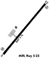
Runways
Runway Summary
| Runways: | 05/23 |
| Longest Runway: | 05/23 is 5254 ft (1601 m) long |
| Runways with an Instrument Approach: |
W40 Airport Runway Details
| Runway 05/23 | 5254 ft x 75 ft (1601 m x 23 m) | |
| Runway Length Source: | 3RD PARTY SURVEY as of 01/22/2019 | |
| Surface: | Asphalt - Excellent condition - No special surface treatment | |
| Runway Edge Lights: | Medium Intensity | |
Runway Weight Bearing Capacity (in thousands of pounds) |
||
| Single Wheel Landing Gear: | 20.0 | |
Runway 05 |
Runway 23 |
|
Elevation: |
166.2 | 166.5 |
Latitude: |
35-12-57.4187N | 35-13-37.0503N |
Longitude: |
078-02-39.5007W | 078-01-58.5363W |
|
Runway True Alignment: |
040 | 220 |
Glide Path Angle: |
3.5 degrees | 3.5 degrees |
Traffic Pattern: |
Left | Left |
Runway Markings Type: |
Nonprecision Instrument | Nonprecision Instrument |
Runway Markings Condition: |
Fair | Fair |
Object at End: |
TREES | ROAD |
Object Height: |
54 | 19 |
Distance from End: |
361 | 279 |
Object Centerline Offset: |
200 ft. right of centerline | 96 ft. left of centerline |
Visual Glide Slope Indicators: |
2-Light PAPI On Left Side Of Runway | 2-Light PAPI On Left Side Of Runway |
Threshold Crossing Height: |
43 | 43 |
Threshold Elevation: |
166.5 | |
Displaced Threshold: |
254 | |
Threshold Latitude: |
35-13-35.1314N | |
Threshold Longitude: |
078-02-00.5193W |
Services
Airframe Repair: |
None |
Powerplant Repair: |
None |
Bottled Oxygen: |
None |
Bulk Oxygen: |
None |
Fuel Available: |
100LL, Jet A-1+ |
Landing Fees: |
No |
Parking: |
Tiedowns available |
Maps & Diagrams
W40 Sectional
Flight Planning
at skyvector.com
at skyvector.com