Location
Latitude: |
41-20-39.4000N (41.344278) |
Longitude: |
082-10-39.5000W (-82.177639) |
Elevation: |
793.2 feet MSL (242 m MSL) |
Magnetic Variation: |
8 W (as of April 2024 from WMM2020 model) |
Time Zone: |
UTC -5.0 (Standard Time) UTC -4.0 (Daylight Savings Time) |
From City: |
06 N.M. S of Lorain/Elyria, Ohio |
Found On: |
Detroit Chart |
FAA Region: |
AGL |
Contacts
Manager: |
Publicly owned: |
| DOUG MCCONNELL C/O MRK AVIATION 44050 RUSSIA RD ELYRIA, OH 44035 440-323-7000 |
LORAIN CO BOARD OF COMMISSIONERS 44050 RUSSIA RD ELYRIA, OH 44035 440-329-5000 |
Operations
Airport Status: |
Operational |
Facility Use: |
Public |
Type: |
Airport |
Control tower: |
No |
Attendance (Months/Days/Hours): |
Months/Days/Hours APR-OCT/ALL/0700-2200 |
Boundary ARTCC: |
ZOB (Cleveland) |
Responsible ARTCC: |
ZOB (Cleveland) |
Lighting Schedule: |
SEE RMK |
Segmented Circle Indicator: |
Yes, Lighted |
Traffic Pattern Altitude (MSL): |
1793 feet (547 m) |
NOTAMs Facility: |
LPR |
NOTAM-D Service: |
Yes |
International Airport of Entry: |
No |
Customs Landing Rights: |
No |
Military Landing Rights: |
Yes |
Civil/Military Joint Use: |
No |
Based Aircraft
| Single Engine: | 77 |
| Multi Engine: | 10 |
| Jet Engine: | 1 |
| GA Helicopters: | 2 |
| Gliders: | 1 |
Annual Operations (as of 09/28/2022)
| Total Operations: | 21773 | |
| Air Taxi: | 1329 | 6.1% |
| GA Local: | 16915 | 77.7% |
| GA Itinerant: | 3529 | 16.2% |
Communications
| CTAF: | 122.700 |
| Unicom: | 122.700 |
| Approach: | CLEVELAND 125.35 125.35 125.35 125.35 125.35 125.35 |
| Departure: | CLEVELAND 125.35 125.35 125.35 125.35 125.35 125.35 |
| ASOS: | 118.925 (440-323-7088) |
Fixed Based Operators (FBOs) & Fuel
(Click on a business for detail)
Please help us keep this information up to date. This is a FREE SERVICE just like everything else on Airport Guide! If you see that a business needs to be added, modified, or deleted please fill out our Update Form.
To add, modify, or delete a business click here.
Please help us keep this information up to date. This is a FREE SERVICE just like everything else on Airport Guide! If you see that a business needs to be added, modified, or deleted please fill out our Update Form.
Area Code: 440 |
| Business Name | Frequency | Phone | Fuel Grade |
|---|---|---|---|
| Aircraft Maintenance, Inc.
Update FBO info |
322-5485 | ||
| Hurst Aviation
Update FBO info |
122.7 | 323-7000 | |
| Lorain County Aviation Services
Website Update FBO info |
Unicom 122.7 | 323-9838 | 100LL, Jet A |
| Skysurance Agency
Update FBO info |
323-3300 | ||
| Zane Pritts Aviation, Inc.
Update FBO info |
322-4945 | 100LL |
Flight Service Stations
| Primary | Alternate | |
| FSS on Field: | N | |
| FSS Name (ID): | Cleveland(CLE) | |
| Frequency: | ||
| Toll Free Phone: | 1-800-WX-BRIEF |
Instrument Procedures / Charts
FAA Terminal Procedures valid from 0901Z 03/21/24 to 0901Z 04/18/24.
There are various types of charts available for an airport. They are listed in the Page Type column. Here is a legend for those types:
APD - Airport Diagram
DP - Departure Procedure Charts
HOT - Hot Spots
IAP - Instrument Approach Procedure Charts
MIN - Minimums
STAR - Standard Terminal Arrival Charts
| Page Type | Page Name | Volume | Action Since Last Cycle |
|---|---|---|---|
| DP | AHMET FOUR (RNAV) | EC-2 | |
| DP | CAVVS FOUR (RNAV) | EC-2 | |
| DP | GTLKE FOUR (RNAV) | EC-2 | |
| DP | MYCAR FOUR (RNAV) | EC-2 | |
| DP | ZAAPA FIVE (RNAV) | EC-2 | |
| IAP | ILS OR LOC RWY 07 | EC-2 | |
| IAP | RNAV (GPS) RWY 07 | EC-2 | |
| IAP | VOR-A | EC-2 | |
| MIN | ALTERNATE MINIMUMS | EC-2 | |
| MIN | TAKEOFF MINIMUMS | EC-2 | |
| STAR | BRWNZ FOUR (RNAV) | EC-2 | |
| STAR | BRWNZ FOUR (RNAV)[DELIMITER] CONT.1 | EC-2 | |
| STAR | BRWNZ FOUR (RNAV)[DELIMITER] CONT.2 | EC-2 | |
| STAR | ROKNN THREE (RNAV) | EC-2 | |
| STAR | ROKNN THREE (RNAV)[DELIMITER] CONT.1 | EC-2 | |
| STAR | ROLLN TWO (RNAV) | EC-2 |
Terminal Procedures are only available for airports in several countries with more being added all the time. If you are looking for a specific country's charts, please send an email to support(at)airportguide.com stating the country name. This will be used to prioritize the implementation.
Navigation Aids (Navaids) near LPR
| Dist (NM) | ID | Morse Code | Name | Type | Freq | True Hdg | Mag Hdg |
|---|---|---|---|---|---|---|---|
| 1.1 | DJB | _ . . . _ _ _ _ . . . | Dryer | VOR-DME | 113.60 | 40 | 48 |
| 15.4 | CLE | _ . _ . . _ . . . | Cleveland | VOT | 110.40 | 72 | 80 |
| 22.2 | SKY | . . . _ . _ _ . _ _ | Sandusky | VOR-DME | 109.20 | 284 | 292 |
| 23.1 | AAU | . _ . _ . . _ | Ashland | NDB | 329 | 188 | 196 |
| 32.8 | PCW | . _ _ . _ . _ . . _ _ | Port Clinton | NDB | 423 | 288 | 296 |
| 34.1 | MFD | _ _ . . _ . _ . . | Mansfield | VORTAC | 108.80 | 213 | 221 |
| 36.7 | MF | _ _ . . _ . | Manns | NDB | 372 | 199 | 207 |
| 39.3 | AK | . _ _ . _ | Akron | NDB | 362 | 114 | 122 |
| 41.2 | LQL | . _ . . _ _ . _ . _ . . | Lakeland | NDB | 263 | 60 | 68 |
| 42.0 | CAK | _ . _ . . _ _ . _ | Akron/Canton Regional | VOT | 110.60 | 127 | 135 |
| 46.3 | ACO | . _ _ . _ . _ _ _ | Akron | VOR-DME | 114.40 | 107 | 115 |
| 46.8 | CXR | _ . _ . _ . . _ . _ . | Chardon | VOR-DME | 112.70 | 76 | 84 |
| 49.2 | TII | _ . . . . | Tiffin | NDB | 269 | 252 | 260 |
| 49.5 | BSV | _ . . . . . . . . . _ | Briggs | VOR-DME | 112.40 | 136 | 144 |
| 50.1 | MLR | _ _ . _ . . . _ . | Millersburg/Dcmsnd | NDB | 382 | 163 | 171 |
| 55.8 | FZI | . . _ . _ _ . . . . | Fostoria | NDB | 379 | 260 | 268 |
| 58.3 | 4L | Chatham | NDB | 236 | 4 | 12 | |
| 59.3 | BUD | _ . . . . . _ _ . . | Buckeye | VOR | 109.80 | 222 | 230 |
| 61.6 | YQG | _ . _ _ _ _ . _ _ _ . | Windsor | VOR-DME | 113.80 | 332 | 340 |
| 63.0 | RYS | . _ . _ . _ _ . . . | Grosse Ile | NDB | 419 | 316 | 324 |
Nearby Airports with Fuel
Notices to Airmen (NOTAMS)
Remarks
| A110*G | THIS AIRPORT HAS BEEN SURVEYED BY THE NATIONAL GEODETIC SURVEY. |
| A110-1 | PILOTS OPERG IN OBERLIN AREA REQD TO AVOID & RMN WELL CLR OF OBERLIN COLLEGE DUE TO MUSIC CONSERVATORY; ALL TFC OPNS NORTH OF ARPT AS PER FAR PART 93 SUBPART J. |
| A110-3 | DEER, BIRDS & OTHER WILDLIFE ON & INVOF ARPT. |
| A110-4 | FOR CD CTC CLEVELAND APCH AT 216-352-2323. |
| A16 | APT MGR CELL PHONE 216-389-6042 OR 330-721-8142 |
| A75 | TNST HNGR STORAGE PPR. |
| A81-APT | HIRL RWY 07/25 PRESET LOW INTST, TO INCR INTST & ACTVT MALSR RWY 07; REIL RWY 25 - CTAF. |
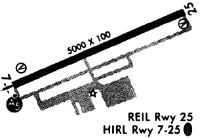
Runways
Runway Summary
| Runways: | 07/25 |
| Longest Runway: | 07/25 is 5002 ft (1525 m) long |
| Runways with an Instrument Approach: | 07 |
LPR Airport Runway Details
| Runway 07/25 | 5002 ft x 100 ft (1525 m x 30 m) | |
| Surface: | Asphalt - Fair condition - Saw-cut or plastic grooved | |
| Runway Edge Lights: | High Intensity | |
Runway Weight Bearing Capacity (in thousands of pounds) |
||
| Single Wheel Landing Gear: | 80.0 | |
| Dual Wheel Landing Gear: | 110.0 | |
| Dual Tandem Wheel Landing Gear: | 180.0 | |
Runway 07 |
Runway 25 |
|
Elevation: |
793.2 | 787.0 |
Latitude: |
41-20-28.9569N | 41-20-49.8343N |
Longitude: |
082-11-09.1740W | 082-10-09.7408W |
|
Runway True Alignment: |
065 | 245 |
ILS Type: |
ILS | |
Glide Path Angle: |
3.0 degrees | 3.0 degrees |
Traffic Pattern: |
Left | Right |
Runway Markings Type: |
Precision Instrument | Nonprecision Instrument |
Runway Markings Condition: |
Fair | Fair |
Visual Glide Slope Indicators: |
4-Light PAPI On Left Side Of Runway | 4-Light PAPI On Left Side Of Runway |
Approach Light System: |
1,400 Foot Medium Intensity Approach Lighting System With Runway Alignment Indicator Lights | |
REIL: |
No | Yes |
Touchdown Lights: |
No | No |
Centerline Lights: |
No | No |
Threshold Crossing Height: |
52 | 40 |
Services
Airframe Repair: |
Major |
Powerplant Repair: |
Major |
Bottled Oxygen: |
High Pressure |
Bulk Oxygen: |
High Pressure / Low Pressure |
Fuel Available: |
100LL, Jet A+ |
Landing Fees: |
No |
Parking: |
Hangars and tiedowns available |
Maps & Diagrams
LPR Sectional
Flight Planning
at skyvector.com
at skyvector.com