Location
Latitude: |
40-52-29.4000N (40.874833) |
Longitude: |
081-53-17.7000W (-81.88825) |
Elevation: |
1135.8 feet MSL (346 m MSL) |
Magnetic Variation: |
8.1 W (as of April 2024 from WMM2020 model) |
Time Zone: |
UTC -5.0 (Standard Time) UTC -4.0 (Daylight Savings Time) |
From City: |
06 N.M. NE of Wooster, Ohio |
Found On: |
Detroit Chart |
FAA Region: |
AGL |
Contacts
Manager: |
Publicly owned: |
| MATTHEW LONG 6020 N HONEYTOWN RD SMITHVILLE, OH 44677 330-669-9212 |
WAYNE COUNTY 428 WEST LIBERTY WOOSTER, OH 44691 330-287-5400 |
Operations
Airport Status: |
Operational |
Facility Use: |
Public |
Type: |
Airport |
Control tower: |
No |
Attendance (Months/Days/Hours): |
Months/Days/Hours ALL/SAT-SUN/0800-1800 |
Boundary ARTCC: |
ZOB (Cleveland) |
Responsible ARTCC: |
ZOB (Cleveland) |
Lighting Schedule: |
SEE RMK |
Segmented Circle Indicator: |
Yes |
Traffic Pattern Altitude (MSL): |
2136 feet (651 m) |
NOTAMs Facility: |
BJJ |
NOTAM-D Service: |
Yes |
International Airport of Entry: |
No |
Customs Landing Rights: |
No |
Military Landing Rights: |
No |
Civil/Military Joint Use: |
No |
Based Aircraft
| Single Engine: | 35 |
| Multi Engine: | 3 |
| Jet Engine: | 5 |
| GA Helicopters: | 5 |
Annual Operations (as of 09/16/2022)
| Total Operations: | 18300 | |
| Air Taxi: | 200 | 1.1% |
| GA Local: | 9000 | 49.2% |
| GA Itinerant: | 9000 | 49.2% |
| Military Aircraft: | 100 | 0.5% |
Communications
| CTAF: | 122.975 |
| Unicom: | 122.975 |
| Clearance Del.: | 121.75 121.75 121.75 |
| Approach: | CLEVELAND CLEVELAND ARTCC |
| Departure: | CLEVELAND CLEVELAND ARTCC |
| ASOS: | 118.075 (330-669-9105) |
- APCH/DEP SVC PRVDD BY CLEVELAND APCH (CLE) 0600-0100. APCH/DEP SVC PRVDD BY CLEVELAND ARTCC (ZOB) ON FREQS 134.9/269.475 (MANSFIELD RCAG) 0100-0600.
Fixed Based Operators (FBOs) & Fuel
(Click on a business for detail)
Please help us keep this information up to date. This is a FREE SERVICE just like everything else on Airport Guide! If you see that a business needs to be added, modified, or deleted please fill out our Update Form.
To add, modify, or delete a business click here.
Please help us keep this information up to date. This is a FREE SERVICE just like everything else on Airport Guide! If you see that a business needs to be added, modified, or deleted please fill out our Update Form.
Area Code: 330 |
| Business Name | Frequency | Phone | Fuel Grade |
|---|---|---|---|
| Mid - Ohio Aviation, Inc.
Update FBO info |
Unicom 122.8 | 669-2671 | 100LL, Jet A |
Flight Service Stations
| Primary | Alternate | |
| FSS on Field: | N | |
| FSS Name (ID): | Cleveland(CLE) | |
| Frequency: | ||
| Toll Free Phone: | 1-800-WX-BRIEF |
Instrument Procedures / Charts
FAA Terminal Procedures valid from 0901Z 03/21/24 to 0901Z 04/18/24.
There are various types of charts available for an airport. They are listed in the Page Type column. Here is a legend for those types:
APD - Airport Diagram
DP - Departure Procedure Charts
HOT - Hot Spots
IAP - Instrument Approach Procedure Charts
MIN - Minimums
STAR - Standard Terminal Arrival Charts
| Page Type | Page Name | Volume | Action Since Last Cycle |
|---|---|---|---|
| IAP | RNAV (GPS) RWY 10 | EC-2 | |
| IAP | RNAV (GPS) RWY 28 | EC-2 | |
| IAP | VOR RWY 10 | EC-2 | |
| IAP | VOR RWY 28 | EC-2 | |
| MIN | ALTERNATE MINIMUMS | EC-2 | |
| MIN | TAKEOFF MINIMUMS | EC-2 |
Terminal Procedures are only available for airports in several countries with more being added all the time. If you are looking for a specific country's charts, please send an email to support(at)airportguide.com stating the country name. This will be used to prioritize the implementation.
Navigation Aids (Navaids) near BJJ
| Dist (NM) | ID | Morse Code | Name | Type | Freq | True Hdg | Mag Hdg |
|---|---|---|---|---|---|---|---|
| 17.4 | AAU | . _ . _ . . _ | Ashland | NDB | 329 | 287 | 295 |
| 20.0 | MLR | _ _ . _ . . . _ . | Millersburg/Dcmsnd | NDB | 382 | 177 | 185 |
| 20.4 | CAK | _ . _ . . _ _ . _ | Akron/Canton Regional | VOT | 110.60 | 82 | 90 |
| 22.2 | BSV | _ . . . . . . . . . _ | Briggs | VOR-DME | 112.40 | 111 | 119 |
| 25.5 | AK | . _ _ . _ | Akron | NDB | 362 | 62 | 70 |
| 26.1 | MF | _ _ . . _ . | Manns | NDB | 372 | 255 | 263 |
| 31.5 | DJB | _ . . . _ _ _ _ . . . | Dryer | VOR-DME | 113.60 | 336 | 344 |
| 31.9 | MFD | _ _ . . _ . _ . . | Mansfield | VORTAC | 108.80 | 269 | 277 |
| 32.7 | CLE | _ . _ . . _ . . . | Cleveland | VOT | 110.40 | 3 | 11 |
| 34.1 | ACO | . _ _ . _ . _ _ _ | Akron | VOR-DME | 114.40 | 65 | 73 |
| 43.0 | CTW | _ . _ . _ . _ _ | Newcomerstown | DME | 111.8 | 154 | 162 |
| 48.2 | SKY | . . . _ . _ _ . _ _ | Sandusky | VOR-DME | 109.20 | 314 | 322 |
| 50.6 | CXR | _ . _ . _ . . _ . _ . | Chardon | VOR-DME | 112.70 | 40 | 48 |
| 53.6 | LQL | . _ . . _ _ . _ . _ . . | Lakeland | NDB | 263 | 25 | 33 |
| 53.9 | APE | . _ . _ _ . . | Appleton | VORTAC | 116.70 | 216 | 224 |
| 55.3 | CFX | _ . _ . . . _ . _ . . _ | Cadiz | NDB | 239 | 133 | 141 |
| 55.6 | BUD | _ . . . . . _ _ . . | Buckeye | VOR | 109.80 | 254 | 262 |
| 56.0 | ZZV | _ _ . . _ _ . . . . . _ | Zanesville | VOR-DME | 114.95 | 180 | 188 |
| 57.3 | HEH | . . . . . . . . . | Newark | NDB | 524 | 207 | 215 |
| 58.1 | HRA | . . . . . _ . . _ | Zanesville | NDB | 204 | 181 | 189 |
Nearby Airports with Fuel
Notices to Airmen (NOTAMS)
Remarks
| A110-1 | DEER ON & INVOF ARPT. |
| A110-4 | FOR CD CTC CLEVELAND APCH AT 216-352-2323, WHEN APCH CLSD CTC CLEVELAND ARTCC AT 440-774-0223. |
| A24 | RAMP FEE FOR ALL ACFT, WAIVED W MIN FUEL PURCHASE. |
| A43-28 | UNUSBL BYD 8 DEG LEFT OF CNTRLN. |
| A57-28 | APCH RATIO 20:1 TO DTHR. |
| A58-28 | 5 FT ROAD 180-200 FT FM RWY END. |
| A81-APT | HIRL RWY 10/28 PRESET LOW INTST DUSK TO DAWN. TO INCR INTST & ACTVT REILS RWY 10/28; PAPI RWY 10; VASI RWY 28 - CTAF. |
Runways
Runway Summary
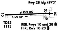
| Runways: | 10/28 |
| Longest Runway: | 10/28 is 5189 ft (1582 m) long |
| Runways with an Instrument Approach: |
BJJ Airport Runway Details
| Runway 10/28 | 5189 ft x 100 ft (1582 m x 30 m) | |
| Runway Length Source: | 3RD PARTY SURVEY as of 08/28/2014 | |
| Surface: | Asphalt - Good condition - Saw-cut or plastic grooved | |
| Runway Edge Lights: | High Intensity | |
Runway Weight Bearing Capacity (in thousands of pounds) |
||
| Single Wheel Landing Gear: | 30.0 | |
Runway 10 |
Runway 28 |
|
Elevation: |
1112.1 | 1135.7 |
Latitude: |
40-52-29.4349N | 40-52-29.4326N |
Longitude: |
081-53-51.5003W | 081-52-43.9565W |
|
Runway True Alignment: |
090 | 270 |
Glide Path Angle: |
3.0 degrees | 3.0 degrees |
Traffic Pattern: |
Left | Left |
Runway Markings Type: |
Nonprecision Instrument | Nonprecision Instrument |
Runway Markings Condition: |
Fair | Fair |
Object at End: |
ROAD | |
Object Height: |
5 | |
Distance from End: |
201 | |
Object Centerline Offset: |
0 ft. left and right of centerline | |
Visual Glide Slope Indicators: |
4-Light PAPI On Left Side Of Runway | 4-Box VASI On Right Side Of Runway |
REIL: |
Yes | Yes |
Touchdown Lights: |
No | No |
Centerline Lights: |
No | No |
Threshold Crossing Height: |
33 | 33 |
Threshold Elevation: |
1133.8 | |
Displaced Threshold: |
218 | |
Threshold Latitude: |
40-52-29.4336N | |
Threshold Longitude: |
081-52-46.7971W |
Services
Airframe Repair: |
Minor |
Powerplant Repair: |
Minor |
Bottled Oxygen: |
None |
Bulk Oxygen: |
None |
Fuel Available: |
100LL |
Landing Fees: |
No |
Parking: |
Hangars and tiedowns available |
Maps & Diagrams
BJJ Sectional
Flight Planning
at skyvector.com
at skyvector.com