Location
Latitude: |
41-41-02.5000N (41.684028) |
Longitude: |
081-23-23.1000W (-81.38975) |
Elevation: |
625.6 feet MSL (191 m MSL) |
Magnetic Variation: |
8.6 W (as of April 2024 from WMM2020 model) |
Time Zone: |
UTC -5.0 (Standard Time) UTC -4.0 (Daylight Savings Time) |
From City: |
03 N.M. N of Willoughby, Ohio |
Found On: |
Detroit Chart |
FAA Region: |
AGL |
Contacts
Manager: |
Publicly owned: |
| PATTY FULOP 38550 JET CENTER PL WILLOUGHBY, OH 44094-8174 440-953-4372 |
LAKE DEVELOPMENT AUTHORITY 105 N MAIN ST STE B501 PAINESVILLE, OH 44077-3414 440-350-5342 |
Operations
Airport Status: |
Operational |
Facility Use: |
Public |
Type: |
Airport |
Activation Date: |
12/1937 |
Control tower: |
No |
Attendance (Months/Days/Hours): |
Months/Days/Hours ALL/ALL/0700-2100 |
Boundary ARTCC: |
ZOB (Cleveland) |
Responsible ARTCC: |
ZOB (Cleveland) |
Lighting Schedule: |
SEE RMK |
Segmented Circle Indicator: |
Yes |
Traffic Pattern Altitude (MSL): |
1626 feet (496 m) |
NOTAMs Facility: |
CLE |
NOTAM-D Service: |
Yes |
International Airport of Entry: |
No |
Customs Landing Rights: |
No |
Military Landing Rights: |
No |
Civil/Military Joint Use: |
No |
Based Aircraft
| Single Engine: | 63 |
| Multi Engine: | 11 |
| Jet Engine: | 7 |
| GA Helicopters: | 1 |
Annual Operations (as of 10/05/2023)
| Total Operations: | 45085 | |
| Air Taxi: | 1547 | 3.4% |
| GA Local: | 24762 | 54.9% |
| GA Itinerant: | 18751 | 41.6% |
| Military Aircraft: | 25 | 0.1% |
Communications
| CTAF: | 122.725 |
| Unicom: | 122.725 |
| Approach: | CLEVELAND 125.35 125.35 125.35 125.35 125.35 125.35 |
| Departure: | CLEVELAND 125.35 125.35 125.35 125.35 125.35 125.35 |
| AWOS-3PT: | 119.225 (440-942-0809) |
Fixed Based Operators (FBOs) & Fuel
(Click on a business for detail)
Please help us keep this information up to date. This is a FREE SERVICE just like everything else on Airport Guide! If you see that a business needs to be added, modified, or deleted please fill out our Update Form.
To add, modify, or delete a business click here.
Please help us keep this information up to date. This is a FREE SERVICE just like everything else on Airport Guide! If you see that a business needs to be added, modified, or deleted please fill out our Update Form.
Area Code: 216 |
| Business Name | Frequency | Phone | Fuel Grade |
|---|---|---|---|
| Cleveland Jet Center, Inc.
Update FBO info |
942-0087 | 100LL, Jet A | |
| Lost Nation Aviation
Update FBO info |
953-2992 | 100LL, Jet A |
Flight Service Stations
| Primary | Alternate | |
| FSS on Field: | N | |
| FSS Name (ID): | Cleveland(CLE) | |
| Frequency: | ||
| Toll Free Phone: | 1-800-WX-BRIEF |
Instrument Procedures / Charts
FAA Terminal Procedures valid from 0901Z 03/21/24 to 0901Z 04/18/24.
There are various types of charts available for an airport. They are listed in the Page Type column. Here is a legend for those types:
APD - Airport Diagram
DP - Departure Procedure Charts
HOT - Hot Spots
IAP - Instrument Approach Procedure Charts
MIN - Minimums
STAR - Standard Terminal Arrival Charts
| Page Type | Page Name | Volume | Action Since Last Cycle |
|---|---|---|---|
| DP | AHMET FOUR (RNAV) | EC-2 | |
| DP | CAVVS FOUR (RNAV) | EC-2 | |
| DP | GTLKE FOUR (RNAV) | EC-2 | |
| DP | MYCAR FOUR (RNAV) | EC-2 | |
| DP | ZAAPA FIVE (RNAV) | EC-2 | |
| IAP | NDB RWY 10 | EC-2 | |
| IAP | RNAV (GPS) RWY 05 | EC-2 | |
| IAP | RNAV (GPS) RWY 10 | EC-2 | |
| IAP | RNAV (GPS) RWY 23 | EC-2 | |
| IAP | RNAV (GPS) RWY 28 | EC-2 | |
| MIN | ALTERNATE MINIMUMS | EC-2 | |
| MIN | TAKEOFF MINIMUMS | EC-2 | |
| STAR | BRWNZ FOUR (RNAV) | EC-2 | |
| STAR | BRWNZ FOUR (RNAV)[DELIMITER] CONT.1 | EC-2 | |
| STAR | BRWNZ FOUR (RNAV)[DELIMITER] CONT.2 | EC-2 | |
| STAR | ROKNN THREE (RNAV) | EC-2 | |
| STAR | ROKNN THREE (RNAV)[DELIMITER] CONT.1 | EC-2 | |
| STAR | ROLLN TWO (RNAV) | EC-2 | |
| STAR | TRYBE FOUR (RNAV) | EC-2 | |
| STAR | TRYBE FOUR (RNAV)[DELIMITER] CONT.1 | EC-2 |
Terminal Procedures are only available for airports in several countries with more being added all the time. If you are looking for a specific country's charts, please send an email to support(at)airportguide.com stating the country name. This will be used to prioritize the implementation.
Navigation Aids (Navaids) near LNN
| Dist (NM) | ID | Morse Code | Name | Type | Freq | True Hdg | Mag Hdg |
|---|---|---|---|---|---|---|---|
| 0.5 | LQL | . _ . . _ _ . _ . _ . . | Lakeland | NDB | 263 | 101 | 110 |
| 14.3 | CXR | _ . _ . _ . . _ . _ . | Chardon | VOR-DME | 112.70 | 134 | 143 |
| 26.1 | CLE | _ . _ . . _ . . . | Cleveland | VOT | 110.40 | 232 | 240 |
| 29.1 | JFN | . _ _ _ . . _ . _ . | Jefferson | DME | 115.2 | 80 | 89 |
| 35.6 | ACO | . _ _ . _ . _ _ _ | Akron | VOR-DME | 114.40 | 166 | 175 |
| 36.9 | AK | . _ _ . _ | Akron | NDB | 362 | 179 | 188 |
| 38.5 | YNG | _ . _ _ _ . _ _ . | Youngstown | VORTAC | 109.00 | 123 | 132 |
| 39.8 | DJB | _ . . . _ _ _ _ . . . | Dryer | VOR-DME | 113.60 | 240 | 248 |
| 46.0 | YN | _ . _ _ _ . | Fetch | NDB | 338 | 128 | 137 |
| 46.1 | CAK | _ . _ . . _ _ . _ | Akron/Canton Regional | VOT | 110.60 | 182 | 191 |
| 48.6 | 4L | Chatham | NDB | 236 | 321 | 329 | |
| 50.1 | HBD | . . . . _ . . . _ . . | Hubbard | NDB | 408 | 129 | 138 |
| 53.0 | ERI | . . _ . . . | Erie | TACAN | 109.40 | 67 | 76 |
| 55.0 | ERI | . . _ . . . | Esmer | NDB | 349 | 66 | 75 |
| 56.6 | BSV | _ . . . . . . . . . _ | Briggs | VOR-DME | 112.40 | 181 | 190 |
| 58.2 | AAU | . _ . _ . . _ | Ashland | NDB | 329 | 222 | 230 |
| 58.7 | SKY | . . . _ . _ _ . _ _ | Sandusky | VOR-DME | 109.20 | 255 | 263 |
| 59.1 | UCP | . . _ _ . _ . . _ _ . | Castle | NDB | 272 | 131 | 140 |
| 63.1 | CQD | _ . _ . _ _ . _ _ . . | Cascade | NDB | 372 | 65 | 74 |
| 66.4 | 7B | St Thomas | NDB | 375 | 10 | 19 |
Nearby Airports with Fuel
Notices to Airmen (NOTAMS)
Remarks
| A110-1 | DEER, BIRDS, & OTR WILDLIFE ON & INVOF ARPT. |
| A110-3 | PAT WORK NA 2300-0800. |
| A110-4 | FOR CD CTC CLEVELAND APCH AT 216-352-2323. |
| A14 | PFULOP@LDAUTHORITY.ORG. |
| A16 | CELL 440-321-9036. |
| A17 | FOR ATTENDANT OR FUEL SER AFT HRS CALL 440-942-7092, 2300-0600 BY PRIOR ARNGMT ONLY. |
| A24 | LDG FEE FOR ALL COML ACFT BY WEIGHT; MULTI-ENG & LRGR. |
| A57-05 | APCH SLP 24:1 TO DTHR OVR +98 FT TREE, 2372 FT DIST, 548 FT L. |
| A57-28 | APCH SLP 10:1 TO DTHR OVR +89 FT TREES, 931 FT DIST, 329 FT L. |
| A81-APT | ACTVT REIL RWY 05, 23, 10, & 28; MIRL RWY 05/23 & 10/28 - CTAF. PAPI RWY 05, 23, 10, & 28 OPR CONSLY. |
Runways
Runway Summary
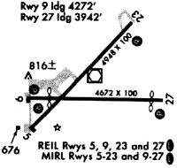
| Runways: | 05/23 10/28 |
| Longest Runway: | 05/23 is 5028 ft (1533 m) long |
| Runways with an Instrument Approach: |
LNN Airport Runway Details
| Runway 05/23 | 5028 ft x 100 ft (1533 m x 30 m) | |
| Runway Length Source: | 3RD PARTY SURVEY as of 08/19/2016 | |
| Surface: | Asphalt - Fair condition - No special surface treatment | |
| Runway Edge Lights: | Medium Intensity | |
Runway Weight Bearing Capacity (in thousands of pounds) |
||
| Single Wheel Landing Gear: | 68.0 | |
| Dual Wheel Landing Gear: | 80.0 | |
| Dual Tandem Wheel Landing Gear: | 124.0 | |
Runway 05 |
Runway 23 |
|
Elevation: |
623.7 | 619.5 |
Latitude: |
41-40-49.5284N | 41-41-24.8977N |
Longitude: |
081-23-50.7972W | 081-23-04.2753W |
|
Runway True Alignment: |
045 | 225 |
Glide Path Angle: |
3.5 degrees | 4.0 degrees |
Traffic Pattern: |
Left | Left |
Runway Markings Type: |
Nonprecision Instrument | Nonprecision Instrument |
Runway Markings Condition: |
Good | Good |
Object at End: |
TREE | TREES |
Object Height: |
62 | 98 |
Distance from End: |
1399 | 1335 |
Object Centerline Offset: |
157 ft. left of centerline | 341 ft. right of centerline |
Visual Glide Slope Indicators: |
4-Light PAPI On Right Side Of Runway | 4-Light PAPI On Left Side Of Runway |
REIL: |
Yes | Yes |
Touchdown Lights: |
No | No |
Centerline Lights: |
No | No |
Threshold Crossing Height: |
29 | 54 |
Threshold Elevation: |
623.8 | |
Displaced Threshold: |
428 | |
Threshold Latitude: |
41-40-52.5370N | |
Threshold Longitude: |
081-23-46.8406W |
| Runway 10/28 | 4272 ft x 100 ft (1302 m x 30 m) | |
| Runway Length Source: | 3RD PARTY SURVEY as of 08/19/2016 | |
| Surface: | Asphalt - Fair condition - No special surface treatment | |
| Runway Edge Lights: | Medium Intensity | |
Runway Weight Bearing Capacity (in thousands of pounds) |
||
| Single Wheel Landing Gear: | 68.0 | |
| Dual Wheel Landing Gear: | 80.0 | |
| Dual Tandem Wheel Landing Gear: | 124.0 | |
Runway 10 |
Runway 28 |
|
Elevation: |
623.6 | 624.1 |
Latitude: |
41-40-57.0656N | 41-40-56.6908N |
Longitude: |
081-23-46.0468W | 081-22-49.7474W |
|
Runway True Alignment: |
091 | 271 |
Glide Path Angle: |
3.5 degrees | 3.5 degrees |
Traffic Pattern: |
Left | Left |
Runway Markings Type: |
Nonprecision Instrument | Nonprecision Instrument |
Runway Markings Condition: |
Good | Good |
Object at End: |
TREES | |
Object Height: |
68 | |
Distance from End: |
738 | |
Object Centerline Offset: |
157 ft. left of centerline | 341 ft. right of centerline |
Visual Glide Slope Indicators: |
2-Light PAPI On Left Side Of Runway | 2-Light PAPI On Left Side Of Runway |
REIL: |
Yes | Yes |
Touchdown Lights: |
No | No |
Centerline Lights: |
No | No |
Threshold Crossing Height: |
47 | 26 |
Threshold Elevation: |
625.6 | |
Displaced Threshold: |
1124 | |
Threshold Latitude: |
41-40-56.7884N | |
Threshold Longitude: |
081-23-04.5541W |
Services
Airframe Repair: |
Major |
Powerplant Repair: |
Major |
Bottled Oxygen: |
None |
Bulk Oxygen: |
None |
Fuel Available: |
100LL |
Landing Fees: |
No |
Parking: |
Hangars and tiedowns available |
Maps & Diagrams
LNN Sectional
Flight Planning
at skyvector.com
at skyvector.com