Location
Latitude: |
29-22-27.1450N (29.374207) |
Longitude: |
100-55-37.7650W (-100.927157) |
Elevation: |
1002.2 feet MSL (305 m MSL) |
Magnetic Variation: |
4.9 E (as of May 2024 from WMM2020 model) |
Time Zone: |
UTC -6.0 (Standard Time) UTC -5.0 (Daylight Savings Time) |
From City: |
02 N.M. NW of Del Rio, Texas |
Found On: |
San Antonio Chart |
FAA Region: |
ASW |
Contacts
Manager: |
Publicly owned: |
| PURNETTE TREVIO (ACTING) 1104 WEST 10TH STREET DEL RIO, TX 78840 (830) 734-4857 |
DEL RIO/VAL VERDE CTY 109 W BROADWAY STREET DEL RIO, TX 78840 (830) 774-8610 |
Operations
Airport Status: |
Operational |
Facility Use: |
Public |
Type: |
Airport |
Activation Date: |
11/1937 |
Control tower: |
No |
Attendance (Months/Days/Hours): |
Months/Days/Hours ALL/ALL/0700-1900 |
Boundary ARTCC: |
ZHU (Houston) |
Responsible ARTCC: |
ZHU (Houston) |
Lighting Schedule: |
SEE RMK |
Segmented Circle Indicator: |
Yes |
Traffic Pattern Altitude (MSL): |
2002 feet (610 m) |
NOTAMs Facility: |
DRT |
NOTAM-D Service: |
Yes |
International Airport of Entry: |
Yes |
Customs Landing Rights: |
No |
Military Landing Rights: |
Yes |
Civil/Military Joint Use: |
No |
Aircraft Rescue and Firefighting: |
Class I ARFF Index: A Air Carrier Service: Scheduled Certification Date: 02/2005 |
Based Aircraft
| Single Engine: | 27 |
| Multi Engine: | 2 |
| GA Helicopters: | 3 |
| Gliders: | 1 |
Annual Operations (as of 07/31/2023)
| Total Operations: | 12684 | |
| Commercial: | 454 | 3.6% |
| Air Taxi: | 1562 | 12.3% |
| GA Local: | 3566 | 28.1% |
| GA Itinerant: | 4187 | 33.0% |
| Military Aircraft: | 2915 | 23.0% |
Communications
| CTAF: | 122.800 |
| Unicom: | 122.800 |
| Approach: | DEL RIO 119.6 119.6 119.6 119.6 HOUSTON ARTCC |
| Departure: | DEL RIO 119.6 119.6 119.6 119.6 HOUSTON ARTCC |
| ASOS: | 118.525 (830-703-8560) |
- APCH/DEP CTL SVC PRVDD BY HOUSTON ARTCC (ZHU) ON FREQS 125.75/346.4 (ROCK SPRINGS RCAG) WHEN DEL RIO APCH CTL (DLF) CLSD.
Fixed Based Operators (FBOs) & Fuel
(Click on a business for detail)
Please help us keep this information up to date. This is a FREE SERVICE just like everything else on Airport Guide! If you see that a business needs to be added, modified, or deleted please fill out our Update Form.
To add, modify, or delete a business click here.
Please help us keep this information up to date. This is a FREE SERVICE just like everything else on Airport Guide! If you see that a business needs to be added, modified, or deleted please fill out our Update Form.
Area Code: 830 |
| Business Name | Frequency | Phone | Fuel Grade |
|---|---|---|---|
| Pico Aviation
Update FBO info |
Unicom 122.8 | 501-940-4016 | 100LL, Jet A |

|
AvFuel | 100LL - 4.71 USD per gallon on 11/18/14 |
Trucks |
|
|
AvFuel | 100LL - 4.30 USD per gallon on 11/18/14 |
Self Serve Pumps |
|
|
AvFuel | Jet A - 3.99 USD per gallon on 11/18/14 |
Self Serve Pumps with Prist |
Flight Service Stations
| Primary | Alternate | |
| FSS on Field: | N | |
| FSS Name (ID): | San Angelo(SJT) | |
| Frequency: | ||
| Toll Free Phone: | 1-800-WX-BRIEF |
Instrument Procedures / Charts
FAA Terminal Procedures valid from 0901Z 03/21/24 to 0901Z 04/18/24.
There are various types of charts available for an airport. They are listed in the Page Type column. Here is a legend for those types:
APD - Airport Diagram
DP - Departure Procedure Charts
HOT - Hot Spots
IAP - Instrument Approach Procedure Charts
MIN - Minimums
STAR - Standard Terminal Arrival Charts
| Page Type | Page Name | Volume | Action Since Last Cycle |
|---|---|---|---|
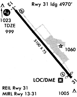
| IAP | ILS OR LOC RWY 13 | SC-3 | |
| IAP | RNAV (GPS) RWY 13 | SC-3 | |
| IAP | VOR-A | SC-3 | |
| MIN | ALTERNATE MINIMUMS | SC-3 | |
| MIN | TAKEOFF MINIMUMS | SC-3 |
Terminal Procedures are only available for airports in several countries with more being added all the time. If you are looking for a specific country's charts, please send an email to support(at)airportguide.com stating the country name. This will be used to prioritize the implementation.
Navigation Aids (Navaids) near DRT
| Dist (NM) | ID | Morse Code | Name | Type | Freq | True Hdg | Mag Hdg |
|---|---|---|---|---|---|---|---|
| 5.3 | DR | _ . . . _ . | Kotti | NDB | 335 | 320 | 315 |
| 8.2 | DLF | _ . . . _ . . . . _ . | Laughlin | VORTAC | 114.40 | 95 | 90 |
| 18.7 | BRX | _ . . . . _ . _ . . _ | La Fonda Ranch | NDB | 269 | 121 | 116 |
| 29.5 | PFO | . _ _ . . . _ . _ _ _ | Spofford | NDB | 356 | 117 | 112 |
| 49.0 | PNG | Piedras | VOR-DME | 113.60 | 155 | 150 | |
| 50.5 | RSG | . _ . . . . _ _ . | Rocksprings | VORTAC | 114.55 | 40 | 35 |
| 57.2 | CPZ | _ . _ . . _ _ . _ _ . . | Chaparrosa Ranch | NDB | 385 | 121 | 116 |
| 62.2 | LKX | . _ . . _ . _ _ . . _ | La Pryor | NDB | 223 | 115 | 110 |
| 64.0 | UVA | . . _ . . . _ . _ | Uvalde | NDB | 281 | 100 | 95 |
| 73.9 | SOA | . . . _ _ _ . _ | Sonora | NDB | 371 | 11 | 6 |
| 77.1 | DMD | _ . . _ _ _ . . | Dimmit County | NDB | 343 | 131 | 126 |
| 91.5 | HDO | . . . . _ . . _ _ _ | Hondo | VOR-DME | 109.40 | 90 | 86 |
| 91.8 | HMA | . . . . _ _ . _ | Hondo | NDB | 329 | 89 | 85 |
| 93.4 | JCT | . _ _ _ _ . _ . _ | Junction | VORTAC | 116.00 | 37 | 32 |
| 95.2 | CSI | _ . _ . . . . . . | Center Point | VORTAC | 117.50 | 69 | 65 |
Nearby Airports with Fuel
| Dist (NM) | Name (Airport IDs) | True Hdg | Mag Hdg | Fuel Grade |
|---|---|---|---|---|
| 62.7 | Garner Field Airport (UVA KUVA UVA) |
98 | 94 | 100LL, Jet A |
| 74.1 | Sonora Municipal Airport (KSOA SOA) |
11 | 6 | 100LL, Jet A |
| 77.3 | Dimmit County Airport (CZT KCZT CZT) |
131 | 127 | 100LL, Jet A |
| 78.2 | Terrell County Airport (6R6) |
301 | 296 | 100LL |
| 82.9 | Ozona Municipal Airport (OZA KOZA OZA) |
350 | 345 | 100LL, Jet A |
| 90.8 | Eldorado Airport (27R) |
10 | 5 | 100LL |
| 91.2 | Kimble County Airport (JCT KJCT JCT) |
41 | 37 | 100LL, Jet A+ |
| 91.5 | South Texas Regional At Hondo Airport (KHDO HDO) |
90 | 86 | 100LL, Jet A |
Notices to Airmen (NOTAMS)
Remarks
| A110-1 | HELIPAD H1 & H2 LCTD SOUTH END OF MAIN PRKG RAMP. |
| A110-2 | FOR CD CTC LAUGHLIN APCH AT 830-298-5192, WHEN APCH CLSD CTC HOUSTON ARTCC AT 281-230-5622. |
| A110-3 | THE NATIONAL WEATHER SERVICE RELEASES WEATHER BALLOONS FROM THE DEL RIO AIRPORT TWICE DAILY (1200 AND 0000 ZULU). |
| A110-4 | ARFF INDEX B AVAILABLE UPON REQUEST |
| A17 | AFT HRS CALL 830-768-0898. |
| A57-13 | 50:1 SLOPE TO THE DSPLCD THR. |
| A81-APT | ACTVT MALS RWY 13; REIL RWY 31; HIRL RWY 13/31; TWY - CTAF. |
Runways
Runway Summary
| Runways: | 13/31 H1 H2 |
| Longest Runway: | 13/31 is 6300 ft (1920 m) long |
| Runways with an Instrument Approach: | 13 |
DRT Airport Runway Details
| Runway 13/31 | 6300 ft x 100 ft (1920 m x 30 m) | |
| Runway Length Source: | FAA as of 09/21/2005 | |
| Surface: | Asphalt - Good condition - No special surface treatment | |
| Runway Edge Lights: | High Intensity | |
Runway Weight Bearing Capacity (in thousands of pounds) |
||
| Single Wheel Landing Gear: | 35.0 | |
| Dual Wheel Landing Gear: | 65.0 | |
| Dual Tandem Wheel Landing Gear: | 110.0 | |
Runway 13 |
Runway 31 |
|
Elevation: |
1002.2 | 995.1 |
Latitude: |
29-22-51.1100N | 29-22-03.1800N |
Longitude: |
100-56-00.5400W | 100-55-14.9900W |
|
Runway True Alignment: |
140 | 320 |
ILS Type: |
ILS/DME | |
Glide Path Angle: |
3.0 degrees | 3.0 degrees |
Traffic Pattern: |
Right | Left |
Runway Markings Type: |
Precision Instrument | Nonprecision Instrument |
Runway Markings Condition: |
Good | Good |
Object at End: |
TREE | TREE |
Object Height: |
31 | 52 |
Distance from End: |
922 | 2105 |
Object Centerline Offset: |
369 ft. left of centerline | 460 ft. left of centerline |
Visual Glide Slope Indicators: |
4-Light PAPI On Left Side Of Runway | 4-Light PAPI On Left Side Of Runway |
Approach Light System: |
1,400 Foot Medium Intensity Approach Lighting System | |
REIL: |
Yes | |
Threshold Crossing Height: |
47 | 62 |
Threshold Elevation: |
1001.5 | |
Displaced Threshold: |
300 | |
Threshold Latitude: |
29-22-48.8300N | |
Threshold Longitude: |
100-55-58.3700W | |
Declared Distances |
||
Take Off Run Avbl. (TORA): |
6300 | 6300 |
Take Off Distance Avbl. (TODA): |
6300 | 6300 |
Actual Stop Dist. Avbl. (ASDA): |
6300 | 5980 |
Landing Dist. Avbl. (LDA): |
6000 | 5980 |
| Helipad H1 | 46 ft x 46 ft (14 m x 14 m) | |
| Runway Length Source: | STATE as of 05/27/2014 | |
| Surface: | Asphalt - Good condition - No special surface treatment | |
Helipad H1 |
||
Elevation: |
1002.2 | |
Latitude: |
29-22-07.1900N | |
Longitude: |
100-55-09.1000W | |
Glide Path Angle: |
0.0 degrees | 0.0 degrees |
Runway Markings Type: |
None | |
Object Centerline Offset: |
369 ft. left of centerline | 460 ft. left of centerline |
| Helipad H2 | 46 ft x 46 ft (14 m x 14 m) | |
| Runway Length Source: | STATE as of 05/27/2014 | |
| Surface: | Asphalt - Good condition - No special surface treatment | |
Helipad H2 |
||
Elevation: |
1002.2 | |
Latitude: |
29-22-08.0000N | |
Longitude: |
100-55-08.0300W | |
Glide Path Angle: |
0.0 degrees | 0.0 degrees |
Runway Markings Type: |
None | |
Object Centerline Offset: |
369 ft. left of centerline | 460 ft. left of centerline |
Services
Airframe Repair: |
Minor |
Powerplant Repair: |
Minor |
Fuel Available: |
100LL, Jet A |
Landing Fees: |
No |
Parking: |
Hangars and tiedowns available |
Maps & Diagrams
DRT Sectional
Flight Planning
at skyvector.com
at skyvector.com