Location
Latitude: |
35-19-53.1580N (35.331433) |
Longitude: |
077-36-31.7880W (-77.60883) |
Elevation: |
92.9 feet MSL (28 m MSL) |
Magnetic Variation: |
9.9 W (as of April 2024 from WMM2020 model) |
Time Zone: |
UTC -5.0 (Standard Time) UTC -4.0 (Daylight Savings Time) |
From City: |
03 N.M. NW of Kinston, North Carolina |
Found On: |
Charlotte Chart |
FAA Region: |
ASO |
Contacts
Manager: |
Publicly owned: |
| RICHARD W. BARKES 2780 JETPORT ROAD SUITE I KINSTON, NC 28504 252-775-6185 |
NORTH CAROLINA 2780 JETPORT ROAD KINSTON, NC 28504 252-775-6180 |
Operations
Airport Status: |
Operational |
Facility Use: |
Public |
Type: |
Airport |
Activation Date: |
08/1944 |
Control tower: |
Yes |
Attendance (Months/Days/Hours): |
Months/Days/Hours ALL/ALL/0630-2200 |
Boundary ARTCC: |
ZDC (Washington) |
Responsible ARTCC: |
ZDC (Washington) |
Lighting Schedule: |
SEE RMK |
Segmented Circle Indicator: |
Yes |
Traffic Pattern Altitude (MSL): |
1093 feet (333 m) |
NOTAMs Facility: |
ISO |
NOTAM-D Service: |
Yes |
International Airport of Entry: |
No |
Customs Landing Rights: |
No |
Military Landing Rights: |
Yes |
Civil/Military Joint Use: |
No |
Aircraft Rescue and Firefighting: |
Class I ARFF Index: A Air Carrier Service: Scheduled Certification Date: 05/1973 |
Based Aircraft
| Single Engine: | 27 |
| Jet Engine: | 41 |
| GA Helicopters: | 2 |
Annual Operations (as of 06/20/2022)
| Total Operations: | 34179 | |
| Commercial: | 20 | 0.1% |
| Air Taxi: | 2196 | 6.4% |
| GA Local: | 8434 | 24.7% |
| GA Itinerant: | 6977 | 20.4% |
| Military Aircraft: | 16552 | 48.4% |
Communications
| CTAF: | 120.600 |
| Unicom: | 122.950 |
| Tower: | KINSTON 120.6 335.55 Hrs: 0630-2200 |
| Ground: | 121.9 |
| Approach: | SEYMOUR JOHNSON 127.3 127.3 WASHINGTON ARTCC |
| Departure: | SEYMOUR JOHNSON 127.3 127.3 WASHINGTON ARTCC |
| AWOS-3: | 132.75 (252-522-2712) |
| EMERG: | 121.5 |
| EMERG: | 243.0 |
- COMMUNICATIONS PRVDD BY RALEIGH RADIO ON FREQ 122.15R (KINSTON RCO).
- APCH/DEP SVC PRVDD BY WASHINGTON ARTCC (ZDC) ON 123.85/279.65 (NEW BERN RCAG) WHEN APCH CTL CLSD.
- PHONE # 252-523-1351
Fixed Based Operators (FBOs) & Fuel
(Click on a business for detail)
Please help us keep this information up to date. This is a FREE SERVICE just like everything else on Airport Guide! If you see that a business needs to be added, modified, or deleted please fill out our Update Form.
To add, modify, or delete a business click here.
Please help us keep this information up to date. This is a FREE SERVICE just like everything else on Airport Guide! If you see that a business needs to be added, modified, or deleted please fill out our Update Form.
Area Code: 252 |
| Business Name | Frequency | Phone | Fuel Grade |
|---|---|---|---|
| ISO Aero Service, Inc.
Update FBO info |
Unicom 122.95 | 522-1135, 800-526-0285 | 100LL, Jet A |
| Kinston Avionics
Update FBO info |
522-3554 |
Flight Service Stations
| Primary | Alternate | |
| FSS on Field: | N | |
| FSS Name (ID): | Raleigh(RDU) | |
| Frequency: | ||
| Toll Free Phone: | 1-800-WX-BRIEF |
Instrument Procedures / Charts
FAA Terminal Procedures valid from 0901Z 03/21/24 to 0901Z 04/18/24.
There are various types of charts available for an airport. They are listed in the Page Type column. Here is a legend for those types:
APD - Airport Diagram
DP - Departure Procedure Charts
HOT - Hot Spots
IAP - Instrument Approach Procedure Charts
MIN - Minimums
STAR - Standard Terminal Arrival Charts
| Page Type | Page Name | Volume | Action Since Last Cycle |
|---|---|---|---|
| APD | AIRPORT DIAGRAM | SE-2 | |
| IAP | ILS OR LOC RWY 05 | SE-2 | |
| IAP | RNAV (GPS) RWY 05 | SE-2 | |
| IAP | RNAV (GPS) RWY 23 | SE-2 | |
| MIN | ALTERNATE MINIMUMS | SE-2 | |
| MIN | TAKEOFF MINIMUMS | SE-2 |
Terminal Procedures are only available for airports in several countries with more being added all the time. If you are looking for a specific country's charts, please send an email to support(at)airportguide.com stating the country name. This will be used to prioritize the implementation.
Navigation Aids (Navaids) near ISO
| Dist (NM) | ID | Morse Code | Name | Type | Freq | True Hdg | Mag Hdg |
|---|---|---|---|---|---|---|---|
| 3.4 | ISO | . . . . . _ _ _ | Kinston | VORTAC | 117.50 | 46 | 56 |
| 6.8 | IS | . . . . . | Stals | NDB | 276 | 219 | 229 |
| 17.7 | GSB | _ _ . . . . _ . . . | Seymour Johnson | TACAN | 116.50 | 270 | 280 |
| 21.6 | PGV | . _ _ . _ _ . . . . _ | Belvoir | FAN MARKER | 30 | 40 | |
| 21.7 | DKA | _ . . _ . _ . _ | Kenan | NDB | 332 | 224 | 234 |
| 25.3 | AQE | . _ _ _ . _ . | Alwood | NDB | 230 | 27 | 37 |
| 26.8 | RNW | . _ . _ . . _ _ | Chocowinity | NDB | 388 | 66 | 76 |
| 31.7 | EWN | . . _ _ _ . | New Bern | VOR-DME | 113.60 | 119 | 129 |
| 31.9 | EW | . . _ _ | Katfi | NDB | 362 | 125 | 135 |
| 35.2 | OA | _ _ _ . _ | Ellas | NDB | 261 | 187 | 197 |
| 36.4 | ETC | . _ _ . _ . | Tarboro | NDB | 257 | 4 | 14 |
| 38.0 | MCZ | _ _ _ . _ . _ _ . . | Williamston | NDB | 336 | 33 | 43 |
| 38.4 | NCA | _ . _ . _ . . _ | New River | TACAN | 115.40 | 167 | 177 |
| 39.0 | TYI | _ _ . _ _ . . | Tar River | VORTAC | 117.80 | 353 | 363 |
| 40.8 | JN | . _ _ _ _ . | Jurly | NDB | 263 | 282 | 292 |
| 42.7 | CTZ | _ . _ . _ _ _ . . | Clinton | NDB | 412 | 240 | 250 |
| 44.3 | NKT | _ . _ . _ _ | Cherry Point | TACAN | 112.80 | 125 | 135 |
| 46.4 | DIW | _ . . . . . _ _ | Dixon | NDB | 198 | 170 | 180 |
| 52.5 | HQT | . . . . _ _ . _ _ | Harnett | NDB | 417 | 276 | 286 |
| 58.8 | MRH | _ _ . _ . . . . . | Morehead | NDB | 269 | 127 | 137 |
Nearby Airports with Fuel
Notices to Airmen (NOTAMS)
Remarks
| A110-1 | ALS UNMON WHEN ATCT IS CLSD. |
| A110-2 | FOR CD IF UNA TO CTC ON FSS FREQ, CTC WASHINGTON ARTCC AT 703-771-3587. |
| A14 | KINSTON REGIONAL JETPORT (DIRECTOR OF OPERATIONS). |
| A26 | CLSD TO UNSKED ACR OPNS WITH MORE THAN 30 PSGR SEATS EXCP 24 HR PPR CALL AMGR 252-523-1351. |
| A81-APT | WHEN ATCT CLSD ACTVT MALSR RWY 05; REIL RWY 23; HIRL RWY 05/23 - CTAF. PAPI RWY 23 OPR CONSLY. |
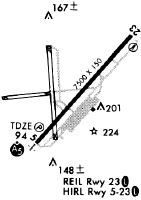
Runways
Runway Summary
| Runways: | 05/23 |
| Longest Runway: | 05/23 is 11498 ft (3505 m) long |
| Runways with an Instrument Approach: | 05 |
ISO Airport Runway Details
| Runway 05/23 | 11498 ft x 150 ft (3505 m x 46 m) | |
| Runway Length Source: | 3RD PARTY SURVEY as of 12/16/2018 | |
| Surface: | Asphalt - Good condition - Saw-cut or plastic grooved | |
| Runway Pavement Class: | 53 /F/A/W/T | |
| Runway Edge Lights: | High Intensity | |
Runway Weight Bearing Capacity (in thousands of pounds) |
||
| Single Wheel Landing Gear: | 120.0 | |
| Dual Wheel Landing Gear: | 219.0 | |
| Dual Tandem Wheel Landing Gear: | 404.0 | |
| Dual Dual Tandem Wheel Landing Gear: | 901.0 | |
Runway 05 |
Runway 23 |
|
Elevation: |
91.2 | 86.2 |
Latitude: |
35-19-10.3101N | 35-20-36.0004N |
Longitude: |
077-37-17.3920W | 077-35-46.1706W |
|
Runway True Alignment: |
041 | 221 |
ILS Type: |
ILS | |
Glide Path Angle: |
3.0 degrees | 3.0 degrees |
Traffic Pattern: |
Left | Left |
Runway Markings Type: |
Precision Instrument | Nonprecision Instrument |
Runway Markings Condition: |
Good | Good |
Object at End: |
POLE | |
Object Height: |
57 | |
Distance from End: |
2150 | |
Object Centerline Offset: |
0 ft. left and right of centerline | 350 ft. left of centerline |
Visual Glide Slope Indicators: |
4-Light PAPI On Left Side Of Runway | 4-Light PAPI On Left Side Of Runway |
Runway Visual Range (RVR): |
Touchdown | Rollout |
Approach Light System: |
1,400 Foot Medium Intensity Approach Lighting System With Runway Alignment Indicator Lights | |
REIL: |
Yes | |
Threshold Crossing Height: |
60 | 74 |
Threshold Elevation: |
91.7 | |
Displaced Threshold: |
538 | |
Threshold Latitude: |
35-19-14.3162N | |
Threshold Longitude: |
077-37-13.1265W |
Services
Airframe Repair: |
Major |
Powerplant Repair: |
Major |
Fuel Available: |
100LL |
Parking: |
Tiedowns available |
Maps & Diagrams
ISO Sectional
Flight Planning
at skyvector.com
at skyvector.com