Location
Latitude: |
31-42-49.8000N (31.713833) |
Longitude: |
082-23-37.6000W (-82.393778) |
Elevation: |
201.2 feet MSL (61 m MSL) |
Magnetic Variation: |
6.6 W (as of May 2024 from WMM2020 model) |
Time Zone: |
UTC -5.0 (Standard Time) UTC -4.0 (Daylight Savings Time) |
From City: |
04 N.M. S of Baxley, Georgia |
Found On: |
Jacksonville Chart |
FAA Region: |
ASO |
Contacts
Manager: |
Publicly owned: |
| VAN MILLS P.O. BOX 290 BAXLEY, GA 31513 (912) 367-3232 |
CITY OF BAXLEY CITY HALL, PO BOX 180 BAXLEY, GA 31513 912-367-8300 |
Operations
Airport Status: |
Operational |
Facility Use: |
Public |
Type: |
Airport |
Activation Date: |
03/1969 |
Control tower: |
No |
Attendance (Months/Days/Hours): |
Months/Days/Hours ALL/MON-FRI/0800-1600 |
Boundary ARTCC: |
ZJX (Jacksonville) |
Responsible ARTCC: |
ZJX (Jacksonville) |
Lighting Schedule: |
SEE RMK |
Segmented Circle Indicator: |
Yes |
Traffic Pattern Altitude (MSL): |
1201 feet (366 m) |
NOTAMs Facility: |
MCN |
NOTAM-D Service: |
Yes |
International Airport of Entry: |
No |
Customs Landing Rights: |
No |
Military Landing Rights: |
Yes |
Civil/Military Joint Use: |
No |
Based Aircraft
| Single Engine: | 22 |
| Multi Engine: | 4 |
Annual Operations (as of 12/31/2021)
| Total Operations: | 12400 | |
| GA Local: | 6000 | 48.4% |
| GA Itinerant: | 6400 | 51.6% |
Communications
| CTAF: | 122.800 |
| Unicom: | 122.800 |
| AWOS-3PT: | 118.2 (912-705-5865) |
- APCH/DEP SVC PRVDD BY JACKSONVILLE ARTCC ON FREQS 127.575/269.025 (ALMA RCAG).
Fixed Based Operators (FBOs) & Fuel
(Click on a business for detail)
Please help us keep this information up to date. This is a FREE SERVICE just like everything else on Airport Guide! If you see that a business needs to be added, modified, or deleted please fill out our Update Form.
To add, modify, or delete a business click here.
Please help us keep this information up to date. This is a FREE SERVICE just like everything else on Airport Guide! If you see that a business needs to be added, modified, or deleted please fill out our Update Form.
Area Code: 912 |
| Business Name | Frequency | Phone | Fuel Grade |
|---|
Flight Service Stations
| Primary | Alternate | |
| FSS on Field: | N | |
| FSS Name (ID): | Macon(MCN) | |
| Frequency: | ||
| Toll Free Phone: | 1-800-WX-BRIEF |
Instrument Procedures / Charts
FAA Terminal Procedures valid from 0901Z 05/16/24 to 0901Z 06/13/24.
There are various types of charts available for an airport. They are listed in the Page Type column. Here is a legend for those types:
APD - Airport Diagram
DP - Departure Procedure Charts
HOT - Hot Spots
IAP - Instrument Approach Procedure Charts
MIN - Minimums
STAR - Standard Terminal Arrival Charts
| Page Type | Page Name | Volume | Action Since Last Cycle |
|---|---|---|---|
| IAP | NDB RWY 08 | SE-4 | |
| IAP | RNAV (GPS) RWY 08 | SE-4 | |
| IAP | RNAV (GPS) RWY 26 | SE-4 | |
| MIN | TAKEOFF MINIMUMS | SE-4 |
Terminal Procedures are only available for airports in several countries with more being added all the time. If you are looking for a specific country's charts, please send an email to support(at)airportguide.com stating the country name. This will be used to prioritize the implementation.
Navigation Aids (Navaids) near KBHC
| Dist (NM) | ID | Morse Code | Name | Type | Freq | True Hdg | Mag Hdg |
|---|---|---|---|---|---|---|---|
| 0.2 | BHC | _ . . . . . . . _ . _ . | Baxley | NDB | 376 | 121 | 128 |
| 12.1 | AMG | . _ _ _ _ _ . | Alma | VORTAC | 115.10 | 208 | 215 |
| 16.3 | AZE | . _ _ _ . . . | Hazlehurst | NDB | 414 | 307 | 314 |
| 23.3 | AY | . _ _ . _ _ | Wiket | NDB | 219 | 180 | 187 |
| 24.0 | RVJ | . _ . . . . _ . _ _ _ | Prison | NDB | 424 | 30 | 37 |
| 27.6 | JES | . _ _ _ . . . . | Slover | NDB | 340 | 110 | 117 |
| 27.9 | AYS | . _ _ . _ _ . . . | Waycross | VORTAC | 110.20 | 197 | 204 |
| 31.0 | UQN | . . _ _ _ . _ _ . | Onyun | NDB | 372 | 9 | 16 |
| 32.8 | OWC | _ _ _ . _ _ _ . _ . | Coffee County | NDB | 390 | 235 | 241 |
| 33.8 | MQW | _ _ _ _ . _ . _ _ | Mc Rae | NDB | 280 | 312 | 318 |
| 39.0 | CWV | _ . _ . . _ _ . . . _ | Claxton | NDB | 395 | 42 | 49 |
| 44.0 | HOE | . . . . _ _ _ . | Homerville | NDB | 209 | 206 | 212 |
| 45.6 | MOQ | _ _ _ _ _ _ _ . _ | Mc Intosh | NDB | 263 | 80 | 87 |
| 46.1 | EZM | . _ _ . . _ _ | Eastman | NDB | 366 | 303 | 309 |
| 46.2 | SUR | . . . . . _ . _ . | Fitzgerald | NDB | 362 | 262 | 268 |
| 54.7 | BQK | _ . . . _ _ . _ _ . _ | Brunswick | VOT | 111.00 | 118 | 125 |
| 55.6 | DBN | _ . . _ . . . _ . | Dublin | VORTAC | 113.10 | 336 | 343 |
| 55.8 | DB | _ . . _ . . . | Creke | NDB | 251 | 325 | 331 |
| 56.1 | BZ | _ . . . _ _ . . | Bullo | NDB | 407 | 41 | 48 |
| 57.2 | EEX | . . _ . . _ | Emanuel County | NDB | 309 | 357 | 364 |
Nearby Airports with Fuel
Notices to Airmen (NOTAMS)
Remarks
| A110*G | THIS AIRPORT HAS BEEN SURVEYED BY THE NATIONAL GEODETIC SURVEY. |
| A110-1 | FOR CD CTC JACKSONVILLE ARTCC AT 904-845-1592. |
| A42-26 | MARKINGS ARE FADED. |
| A70-FUEL-10 | 0LL FUEL 24 HR CREDIT CARD SVC AVBL. |
| A81-APT | DUSK-DAWN. MIRL RWY 08/26 OPER DUSK-2200; AFTER 2200- CTAF. |
| A81-BCN | DUSK-2200. AFTER 2200, ACTVT ROTG BCN - CTAF. |
Runways
Runway Summary
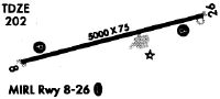
| Runways: | 08/26 |
| Longest Runway: | 08/26 is 5003 ft (1525 m) long |
| Runways with an Instrument Approach: |
KBHC Airport Runway Details
| Runway 08/26 | 5003 ft x 75 ft (1525 m x 23 m) | |
| Runway Length Source: | NGS as of 02/22/2006 | |
| Surface: | Asphalt - Excellent condition - No special surface treatment | |
| Runway Edge Lights: | Medium Intensity | |
Runway Weight Bearing Capacity (in thousands of pounds) |
||
| Single Wheel Landing Gear: | 19.0 | |
Runway 08 |
Runway 26 |
|
Elevation: |
200.5 | 200.8 |
Latitude: |
31-42-43.3696N | 31-42-56.2935N |
Longitude: |
082-24-05.5877W | 082-23-09.6733W |
|
Runway True Alignment: |
075 | 255 |
Glide Path Angle: |
3.0 degrees | 3.0 degrees |
Traffic Pattern: |
Left | Left |
Runway Markings Type: |
Nonprecision Instrument | Nonprecision Instrument |
Runway Markings Condition: |
Good | Good |
Visual Glide Slope Indicators: |
2-Light PAPI On Left Side Of Runway | 2-Light PAPI On Left Side Of Runway |
REIL: |
No | No |
Threshold Crossing Height: |
31 | 31 |
Services
Airframe Repair: |
None |
Powerplant Repair: |
None |
Bottled Oxygen: |
None |
Bulk Oxygen: |
None |
Fuel Available: |
100LL |
Landing Fees: |
No |
Parking: |
Tiedowns available |
Maps & Diagrams
KBHC Sectional
Flight Planning
at skyvector.com
at skyvector.com