Location
Latitude: |
42-33-59.6000N (42.566556) |
Longitude: |
075-31-26.8000W (-75.524111) |
Elevation: |
1024.4 feet MSL (312 m MSL) |
Magnetic Variation: |
12.2 W (as of April 2024 from WMM2020 model) |
Time Zone: |
UTC -5.0 (Standard Time) UTC -4.0 (Daylight Savings Time) |
From City: |
02 N.M. N of Norwich, New York |
Found On: |
New York Chart |
FAA Region: |
AEA |
Contacts
Manager: |
Publicly owned: |
| SHANE H. BUTLER 6390 STATE HWY 12 NORWICH, NY 13815 607-334-9430 |
CHENANGO COUNTY 5 COURT ST. NORWICH, NY 13815 607-337-1640 |
Operations
Airport Status: |
Operational |
Facility Use: |
Public |
Type: |
Airport |
Activation Date: |
02/1940 |
Control tower: |
No |
Attendance (Months/Days/Hours): |
Months/Days/Hours ALL/MON-FRI/0700-1500 |
Boundary ARTCC: |
ZBW (Boston) |
Responsible ARTCC: |
ZBW (Boston) |
Lighting Schedule: |
SEE RMK |
Segmented Circle Indicator: |
Yes |
Traffic Pattern Altitude (MSL): |
2024 feet (617 m) |
NOTAMs Facility: |
OIC |
NOTAM-D Service: |
Yes |
International Airport of Entry: |
No |
Customs Landing Rights: |
No |
Military Landing Rights: |
Yes |
Civil/Military Joint Use: |
No |
Based Aircraft
| Single Engine: | 16 |
| Multi Engine: | 4 |
Annual Operations (as of 09/03/2020)
| Total Operations: | 17300 | |
| Air Taxi: | 3200 | 18.5% |
| GA Local: | 9500 | 54.9% |
| GA Itinerant: | 4500 | 26.0% |
| Military Aircraft: | 100 | 0.6% |
Communications
| CTAF: | 122.800 |
| Unicom: | 122.800 |
| AWOS-3: | 119.025 (607-336-8583) |
- APCH/DEP SVC PRVDD BY BOSTON ARTCC ON FREQS 133.25/279.5 (ROCKDALE RCAG).
Fixed Based Operators (FBOs) & Fuel
(Click on a business for detail)
Please help us keep this information up to date. This is a FREE SERVICE just like everything else on Airport Guide! If you see that a business needs to be added, modified, or deleted please fill out our Update Form.
To add, modify, or delete a business click here.
Please help us keep this information up to date. This is a FREE SERVICE just like everything else on Airport Guide! If you see that a business needs to be added, modified, or deleted please fill out our Update Form.
Area Code: 607 |
| Business Name | Frequency | Phone | Fuel Grade |
|---|---|---|---|
| Lt. Warren Eaton Airport
Update FBO info |
Unicom 122.8 | 334-9430 | 100LL, Jet A |
| Norwich Flight Instruction
Update FBO info |
607 334-9020 | ||
| Ogden Flight Services Group, Inc.
Website Update FBO info |
Unicom 122.8 | 334-9430 | 100LL, Jet A |
Flight Service Stations
| Primary | Alternate | |
| FSS on Field: | N | |
| FSS Name (ID): | Buffalo(BUF) | |
| Frequency: | ||
| Toll Free Phone: | 1-800-WX-BRIEF |
Instrument Procedures / Charts
FAA Terminal Procedures valid from 0901Z 03/21/24 to 0901Z 04/18/24.
There are various types of charts available for an airport. They are listed in the Page Type column. Here is a legend for those types:
APD - Airport Diagram
DP - Departure Procedure Charts
HOT - Hot Spots
IAP - Instrument Approach Procedure Charts
MIN - Minimums
STAR - Standard Terminal Arrival Charts
| Page Type | Page Name | Volume | Action Since Last Cycle |
|---|---|---|---|
| IAP | RNAV (GPS) RWY 01 | NE-2 | |
| IAP | RNAV (GPS) RWY 19 | NE-2 | |
| MIN | TAKEOFF MINIMUMS | NE-2 |
Terminal Procedures are only available for airports in several countries with more being added all the time. If you are looking for a specific country's charts, please send an email to support(at)airportguide.com stating the country name. This will be used to prioritize the implementation.
Navigation Aids (Navaids) near OIC
| Dist (NM) | ID | Morse Code | Name | Type | Freq | True Hdg | Mag Hdg |
|---|---|---|---|---|---|---|---|
| 14.0 | RKA | . _ . _ . _ . _ | Rockdale | VOR-DME | 112.60 | 115 | 127 |
| 18.9 | GGT | _ _ . _ _ . _ | Georgetown | TACAN | 117.80 | 315 | 327 |
| 23.8 | OZ | _ _ _ _ _ . . | Kring | NDB | 279 | 87 | 99 |
| 31.6 | HNK | . . . . _ . _ . _ | Hancock | VOR-DME | 116.80 | 162 | 174 |
| 31.8 | UCA | . . _ _ . _ . . _ | Utica | TACAN | 111.20 | 29 | 41 |
| 32.1 | BG | _ . . . _ _ . | Smite | NDB | 332 | 210 | 222 |
| 34.3 | DNY | _ . . _ . _ . _ _ | Delancey | VOR-DME | 112.10 | 132 | 144 |
| 36.6 | CFB | _ . _ . . . _ . _ . . . | Binghamton | VOR-DME | 112.20 | 228 | 240 |
| 38.2 | IT | . . _ | Vrnah | NDB | 266 | 257 | 269 |
| 41.6 | ITH | . . _ . . . . | Ithaca | DME | 111.8 | 264 | 276 |
| 46.5 | SYR | . . . _ . _ _ . _ . | Syracuse | VORTAC | 117.00 | 320 | 332 |
| 55.2 | FZ | . . _ . _ _ . . | Falln | NDB | 220 | 321 | 333 |
| 56.3 | MS | _ _ . . . | Monga | NDB | 359 | 148 | 160 |
| 58.3 | ALP | . _ . _ . . . _ _ . | Alpine | NDB | 245 | 250 | 262 |
| 58.6 | JJH | . _ _ _ . _ _ _ . . . . | Johnstown | NDB | 523 | 63 | 76 |
| 65.5 | LHY | . _ . . . . . . _ . _ _ | Lake Henry | VORTAC | 110.80 | 178 | 190 |
| 67.8 | PYA | . _ _ . _ . _ _ . _ | Penn Yan | NDB | 260 | 274 | 286 |
| 72.2 | HEU | . . . . . . . _ | Hunter | NDB | 356 | 75 | 88 |
| 72.3 | ULW | . . _ . _ . . . _ _ | Elmira | VOR-DME | 109.65 | 247 | 259 |
| 75.8 | ALB | . _ . _ . . _ . . . | Albany | VOT | 108.20 | 81 | 94 |
Nearby Airports with Fuel
Notices to Airmen (NOTAMS)
Remarks
| A110-1 | NUMEROUS MTNS PIERCE CONICAL SFC AROUND ARPT. |
| A110-3 | RY 19 HAS 15 FT DROPOFF 30 FT FM THLD ON WEST SIDE. |
| A110-4 | RY SAFETY AREAS HAVE DEPRESSIONS IN SFC. |
| A110-6 | GEESE & DEER ON & INVOF ARPT. |
| A110-7 | FOR CD CTC BOSTON ARTCC AT 603-879-6859. |
| A17 | UNATNDD CHRISTMAS. |
| A24 | OVNGT TIE-DOWN FEE; FEE WAIVED WITH FUEL PURCHASE. |
| A43-01 | UNUSBL BYD 4 DEGS LEFT OF CNTRLN. |
| A43-19 | UNUSBL BYD 3 NM AND BYD 4 DEGS LEFT OF CNTRLN. |
| A57-01 | RWY 01 6:1 CLOSE IN SLP TO DTHR +45 FT TREE 11 FT FM RWY END 216 FT RIGHT. |
| A57-19 | RWY 19 - 50:1 SLP TO DTHR. |
| A58-01 | RWY 01 46 FT TREES, 0-200 FT FM RWY END, 222 FT RIGHT OF CNTRLN. |
| A58-19 | RWY 19 +6 FT TREE 154 FT FM RWY END 75 FT RIGHT. |
| A70-FUEL-10 | 0LL SELF-SVC FUEL AVBL 24/7 WITH CREDIT CARD. |
| A81-APT | ACTVT REIL RWY 19; PAPI RWY 01 & 19; HIRL RWY 01/19 - CTAF. |
| E111 | ARPT ESTABLISHED 6/17/52. |
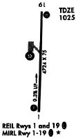
Runways
Runway Summary
| Runways: | 01/19 |
| Longest Runway: | 01/19 is 4727 ft (1441 m) long |
| Runways with an Instrument Approach: |
OIC Airport Runway Details
| Runway 01/19 | 4727 ft x 75 ft (1441 m x 23 m) | |
| Runway Length Source: | 3RD PARTY SURVEY as of 08/02/2012 | |
| Surface: | Asphalt - Good condition - Saw-cut or plastic grooved | |
| Runway Pavement Class: | 14 /F/A/X/T | |
| Runway Edge Lights: | High Intensity | |
Runway Weight Bearing Capacity (in thousands of pounds) |
||
| Single Wheel Landing Gear: | 48.5 | |
| Dual Wheel Landing Gear: | 68.0 | |
Runway 01 |
Runway 19 |
|
Elevation: |
1009.0 | 1024.2 |
Latitude: |
42-33-36.2896N | 42-34-22.9329N |
Longitude: |
075-31-28.2278W | 075-31-25.3804W |
|
Runway True Alignment: |
003 | 183 |
Glide Path Angle: |
4.0 degrees | 3.8 degrees |
Traffic Pattern: |
Left | Left |
Runway Markings Type: |
Nonprecision Instrument | Nonprecision Instrument |
Runway Markings Condition: |
Good | Fair |
Object at End: |
TREES | ROAD |
Object Height: |
41 | 19 |
Distance from End: |
502 | 301 |
Object Centerline Offset: |
18 ft. right of centerline | 134 ft. left of centerline |
Visual Glide Slope Indicators: |
2-Light PAPI On Left Side Of Runway | 2-Light PAPI On Left Side Of Runway |
REIL: |
No | Yes |
Threshold Crossing Height: |
34 | 50 |
Threshold Elevation: |
1011.0 | 1023.6 |
Displaced Threshold: |
275 | 333 |
Threshold Latitude: |
42-33-39.0018N | 42-34-19.6501N |
Threshold Longitude: |
075-31-28.0644W | 075-31-25.5772W |
Declared Distances |
||
Take Off Run Avbl. (TORA): |
4727 | 4727 |
Take Off Distance Avbl. (TODA): |
4727 | 4727 |
Actual Stop Dist. Avbl. (ASDA): |
4394 | 4452 |
Landing Dist. Avbl. (LDA): |
4119 | 4119 |
Services
Airframe Repair: |
None |
Powerplant Repair: |
None |
Bottled Oxygen: |
None |
Bulk Oxygen: |
None |
Fuel Available: |
100LL |
Landing Fees: |
No |
Parking: |
Hangars and tiedowns available |
Maps & Diagrams
OIC Sectional
Flight Planning
at skyvector.com
at skyvector.com