Location
Latitude: |
48-49-49.7000N (48.830472) |
Longitude: |
100-25-02.3000W (-100.417306) |
Elevation: |
1680.1 feet MSL (512 m MSL) |
Magnetic Variation: |
5.4 E (as of May 2024 from WMM2020 model) |
Time Zone: |
UTC -6.0 (Standard Time) UTC -5.0 (Daylight Savings Time) |
From City: |
01 N.M. E of Bottineau, North Dakota |
Found On: |
Twin Cities Chart |
FAA Region: |
AGL |
Contacts
Manager: |
Publicly owned: |
| LEO JOSTAD 9770 13TH AVE NE BOTTINEAU, ND 58318 (701) 228-2983 |
BOTTINEAU AIRPORT AUTH 9770 13TH AVE NE BOTTINEAU, ND 58318 (701) 228-2983 |
Operations
Airport Status: |
Operational |
Facility Use: |
Public |
Type: |
Airport |
Activation Date: |
10/1959 |
Control tower: |
No |
Attendance (Months/Days/Hours): |
Months/Days/Hours ALL/MON-FRI/0800-1700 |
Boundary ARTCC: |
ZMP (Minneapolis) |
Responsible ARTCC: |
ZMP (Minneapolis) |
Lighting Schedule: |
SEE RMK |
Segmented Circle Indicator: |
Yes |
Traffic Pattern Altitude (MSL): |
2680 feet (817 m) |
NOTAMs Facility: |
GFK |
NOTAM-D Service: |
Yes |
International Airport of Entry: |
No |
Customs Landing Rights: |
No |
Military Landing Rights: |
Yes |
Civil/Military Joint Use: |
No |
Based Aircraft
| Single Engine: | 19 |
| Jet Engine: | 1 |
Annual Operations (as of 07/16/2018)
| Total Operations: | 5360 | |
| Air Taxi: | 260 | 4.9% |
| GA Local: | 2800 | 52.2% |
| GA Itinerant: | 2200 | 41.0% |
| Military Aircraft: | 100 | 1.9% |
Communications
| CTAF: | 122.800 |
| Unicom: | 122.800 |
| Approach: | MINOT 119.6 119.6 MINNEAPOLIS ARTCC |
| Departure: | MINOT 119.6 119.6 MINNEAPOLIS ARTCC |
| AWOS-3PT: | 118.25 (701-228-2688) |
- APCH/DEP SVC PRVDD BY MINNEAPOLIS ARTCC ON FREQS 127.6/279.6 (MINOT RCAG) WHEN MINOT APCH CTL CLSD.
Fixed Based Operators (FBOs) & Fuel
(Click on a business for detail)
Please help us keep this information up to date. This is a FREE SERVICE just like everything else on Airport Guide! If you see that a business needs to be added, modified, or deleted please fill out our Update Form.
To add, modify, or delete a business click here.
Please help us keep this information up to date. This is a FREE SERVICE just like everything else on Airport Guide! If you see that a business needs to be added, modified, or deleted please fill out our Update Form.
Area Code: 701 |
| Business Name | Frequency | Phone | Fuel Grade |
|---|---|---|---|
| Botno Aircraft Services
Update FBO info |
Unicom 122.8 | 228-5265 | 100LL |
Flight Service Stations
| Primary | Alternate | |
| FSS on Field: | N | |
| FSS Name (ID): | Grand Forks(GFK) | |
| Frequency: | ||
| Toll Free Phone: | 1-800-WX-BRIEF |
Instrument Procedures / Charts
FAA Terminal Procedures valid from 0901Z 05/16/24 to 0901Z 06/13/24.
There are various types of charts available for an airport. They are listed in the Page Type column. Here is a legend for those types:
APD - Airport Diagram
DP - Departure Procedure Charts
HOT - Hot Spots
IAP - Instrument Approach Procedure Charts
MIN - Minimums
STAR - Standard Terminal Arrival Charts
| Page Type | Page Name | Volume | Action Since Last Cycle |
|---|---|---|---|
| IAP | RNAV (GPS) RWY 31 | NC-1 | |
| MIN | TAKEOFF MINIMUMS | NC-1 |
Terminal Procedures are only available for airports in several countries with more being added all the time. If you are looking for a specific country's charts, please send an email to support(at)airportguide.com stating the country name. This will be used to prioritize the implementation.
Navigation Aids (Navaids) near D09
| Dist (NM) | ID | Morse Code | Name | Type | Freq | True Hdg | Mag Hdg |
|---|---|---|---|---|---|---|---|
| 45.1 | MIB | _ _ . . _ . . . | Deering | TACAN | 114.90 | 236 | 230 |
| 48.6 | MOT | _ _ _ _ _ _ | Minot | VOR-DME | 117.10 | 225 | 219 |
| 66.0 | BR | Brandon | NDB | 233 | 11 | 6 | |
| 67.3 | YBR | _ . _ _ _ . . . . _ . | Brandon | VORTAC | 113.80 | 15 | 10 |
| 73.7 | DVL | _ . . . . . _ . _ . . | Devils Lake | VOR-DME | 114.75 | 125 | 120 |
| 87.9 | 8A | Carlyle | NDB | 310 | 304 | 298 | |
| 98.8 | L7 | Estevan | NDB | 395 | 284 | 278 |
Nearby Airports with Fuel
| Dist (NM) | Name (Airport IDs) | True Hdg | Mag Hdg | Fuel Grade |
|---|---|---|---|---|
| 0.0 | Bottineau Municipal Airport (D09) |
0 | 355 | 100LL |
| 24.4 | Rolette Airport (2H9) |
113 | 108 | 100lL |
| 30.7 | Rugby Municipal Airport (KRUG RUG) |
149 | 144 | 100LL, Jet A |
| 31.6 | Rolla Municipal/Leonard Krech Field Airport (06D) |
83 | 78 | 100LL, Jet A |
| 44.4 | Mohall Municipal Airport (KHBC HBC) |
265 | 259 | 100LL, Jet A |
| 48.5 | Minot International Airport (MOT KMOT MOT) |
225 | 219 | 100LL, Jet A |
| 65.2 | Kenmare Municipal Airport (7K5) |
262 | 255 | 100LL |
| 65.3 | Harvey Municipal Airport (5H4) |
162 | 157 | 100LL |
| 67.3 | Brandon Municipal Airport (YBR CYBR CYBR) |
15 | 10 | 100LL, Jet A |
| 73.7 | Devils Lake Regional Airport (DVL KDVL DVL) |
124 | 120 | 100LL, Jet A |
| 85.1 | Stanley Municipal Airport (08D) |
248 | 241 | 100LL, Jet A+, MOGAS |
| 87.2 | Parshall-Hankins Airport (Y74) |
232 | 225 | 100LL |
| 92.0 | Washburn Municipal Airport (5C8) |
195 | 189 | 100LL |
| 99.4 | Walhalla Municipal Airport (96D) |
85 | 82 | 100LL |
Notices to Airmen (NOTAMS)
Remarks
| A110-2 | CFM WINTER COND BEFORE USE AFTER MAJOR WINTER STORM WITH AMGR CALL 701-228-5265. |
| A110-3 | RY 03/21 CLSD WINTER MONTHS DUE TO LACK OF SNOW REMOVAL. |
| A110-5 | BIRDS ON & INVOF ARPT SEP-NOV. |
| A110-6 | FOR CD CTC MINNEAPOLIS ARTCC AT 651-463-5588. |
| A13 | LEO JOSTAD, APT AUTHORITY CHAIRMAN. |
| A17 | FOR ATTENDANT SAT-SUN CALL 701-228-2983. |
| A42-03 | RYS 03 & 21 MKD WITH BLACK/WHITE CONES. |
| A52-21 | +325 HILL RANGE 10000 FT FM THLD; ALSO +20 FT RD 350 FT FM THLD; 150 FT R; APCH RATIO 17:1. |
| A57-21 | DISPLACED THRESHOLD APPROACH SLOPE 20:1 |
| A70-FUEL-10 | 0LL FOR FUEL CTC 701-228-5265 AFT HRS 701-228-5103 OR 701-228-2983. |
| A76 | FOR AGRI CTC 701-228-2785; FOR INSTR CTC 701-228-2983; FOR REPAIRS CTC 701-228-5265. |
| A81-APT | ACTVT MIRL RY 13/31 & PAPI RYS 13 & 31 - CTAF |
Runways
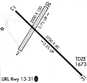
Runway Summary
| Runways: | 03/21 13/31 |
| Longest Runway: | 13/31 is 3700 ft (1128 m) long |
| Runways with an Instrument Approach: |
D09 Airport Runway Details
| Runway 03/21 | 2115 ft x 170 ft (645 m x 52 m) | |
| Runway Length Source: | 3RD PARTY SURVEY as of 06/27/2014 | |
| Surface: | Turf - Good condition - No special surface treatment | |
Runway 03 |
Runway 21 |
|
Elevation: |
1667.7 | 1680.1 |
Latitude: |
48-49-45.1771N | 48-50-02.1668N |
Longitude: |
100-25-18.1678W | 100-24-59.8150W |
|
Runway True Alignment: |
035 | 215 |
Glide Path Angle: |
0.0 degrees | 0.0 degrees |
Traffic Pattern: |
Left | Left |
Runway Markings Type: |
Nonstandard (other than numbers only) | Nonstandard (other than numbers only) |
Object at End: |
ROAD | |
Object Height: |
25 | |
Distance from End: |
450 | |
Object Centerline Offset: |
170 ft. right of centerline | |
REIL: |
No | No |
Touchdown Lights: |
No | No |
Centerline Lights: |
No | No |
| Runway 13/31 | 3700 ft x 60 ft (1128 m x 18 m) | |
| Surface: | Turf - Good condition - No special surface treatment | |
| Runway Edge Lights: | Medium Intensity | |
Runway Weight Bearing Capacity (in thousands of pounds) |
||
| Single Wheel Landing Gear: | 12.5 | |
Runway 13 |
Runway 31 |
|
Elevation: |
1679.1 | 1661.4 |
Latitude: |
48-50-00.2891N | 48-49-34.4278N |
Longitude: |
100-25-17.9979W | 100-24-38.9862W |
|
Runway True Alignment: |
135 | 315 |
Glide Path Angle: |
3.0 degrees | 3.0 degrees |
Traffic Pattern: |
Left | Left |
Runway Markings Type: |
Nonprecision Instrument | Nonprecision Instrument |
Runway Markings Condition: |
Fair | Fair |
Object at End: |
ROAD | |
Object Height: |
23 | |
Distance from End: |
615 | |
Object Centerline Offset: |
170 ft. right of centerline | |
Visual Glide Slope Indicators: |
2-Light PAPI On Right Side Of Runway | 2-Light PAPI On Left Side Of Runway |
REIL: |
No | No |
Touchdown Lights: |
No | No |
Centerline Lights: |
No | No |
Threshold Crossing Height: |
30 | 30 |
Services
Airframe Repair: |
None |
Powerplant Repair: |
None |
Bottled Oxygen: |
None |
Bulk Oxygen: |
None |
Fuel Available: |
100LL |
Landing Fees: |
No |
Parking: |
Tiedowns available |
Maps & Diagrams
D09 Sectional
Flight Planning
at skyvector.com
at skyvector.com