Location
Latitude: |
48-23-25.3000N (48.390361) |
Longitude: |
100-01-27.4000W (-100.024278) |
Elevation: |
1549.2 feet MSL (472 m MSL) |
Magnetic Variation: |
5.1 E (as of April 2024 from WMM2020 model) |
Time Zone: |
UTC -6.0 (Standard Time) UTC -5.0 (Daylight Savings Time) |
From City: |
02 N.M. NW of Rugby, North Dakota |
Found On: |
Twin Cities Chart |
FAA Region: |
AGL |
Contacts
Manager: |
Publicly owned: |
| STEVE SCHNEIDER 516 6TH ST SE RUGBY, ND 58368 701-776-5171 |
RUGBY ARPT AUTH 516 6TH ST SE RUGBY, ND 58368 701-776-5746 |
Operations
Airport Status: |
Operational |
Facility Use: |
Public |
Type: |
Airport |
Control tower: |
No |
Attendance (Months/Days/Hours): |
Months/Days/Hours ALL/MON-FRI/0800-1700 |
Boundary ARTCC: |
ZMP (Minneapolis) |
Responsible ARTCC: |
ZMP (Minneapolis) |
Lighting Schedule: |
SEE RMK |
Segmented Circle Indicator: |
Yes |
Traffic Pattern Altitude (MSL): |
2549 feet (777 m) |
NOTAMs Facility: |
GFK |
NOTAM-D Service: |
Yes |
Military Landing Rights: |
No |
Civil/Military Joint Use: |
No |
Based Aircraft
| Single Engine: | 11 |
| Multi Engine: | 1 |
Annual Operations (as of 06/03/2021)
| Total Operations: | 4250 | |
| Air Taxi: | 300 | 7.1% |
| GA Local: | 2800 | 65.9% |
| GA Itinerant: | 1100 | 25.9% |
| Military Aircraft: | 50 | 1.2% |
Communications
| CTAF: | 122.800 |
| Unicom: | 122.800 |
| AWOS-3: | 118.475 (701-776-6100) |
- COMMUNICATIONS PRVDD BY GRAND FORKS RADIO ON FREQ 122.2 (MINOT RCO).
- APCH/DEP SVC PRVDD BY MINNEAPOLIS ARTCC (ZMP) ON FREQ 127.6/279.6 (MINOT RCAG).
Fixed Based Operators (FBOs) & Fuel
(Click on a business for detail)
Please help us keep this information up to date. This is a FREE SERVICE just like everything else on Airport Guide! If you see that a business needs to be added, modified, or deleted please fill out our Update Form.
To add, modify, or delete a business click here.
Please help us keep this information up to date. This is a FREE SERVICE just like everything else on Airport Guide! If you see that a business needs to be added, modified, or deleted please fill out our Update Form.
Area Code: 701 |
| Business Name | Frequency | Phone | Fuel Grade |
|---|---|---|---|
| Schneider Aerial Spraying
Update FBO info |
Unicom 122.8 | 776-5171, -5176 | 100LL |
Flight Service Stations
| Primary | Alternate | |
| FSS on Field: | N | |
| FSS Name (ID): | Grand Forks(GFK) | |
| Frequency: | ||
| Toll Free Phone: | 1-800-WX-BRIEF |
Instrument Procedures / Charts
FAA Terminal Procedures valid from 0901Z 03/21/24 to 0901Z 04/18/24.
There are various types of charts available for an airport. They are listed in the Page Type column. Here is a legend for those types:
APD - Airport Diagram
DP - Departure Procedure Charts
HOT - Hot Spots
IAP - Instrument Approach Procedure Charts
MIN - Minimums
STAR - Standard Terminal Arrival Charts
| Page Type | Page Name | Volume | Action Since Last Cycle |
|---|---|---|---|
| IAP | RNAV (GPS) RWY 12 | NC-1 | |
| IAP | RNAV (GPS) RWY 30 | NC-1 | |
| MIN | ALTERNATE MINIMUMS | NC-1 | |
| MIN | TAKEOFF MINIMUMS | NC-1 |
Terminal Procedures are only available for airports in several countries with more being added all the time. If you are looking for a specific country's charts, please send an email to support(at)airportguide.com stating the country name. This will be used to prioritize the implementation.
Navigation Aids (Navaids) near KRUG
| Dist (NM) | ID | Morse Code | Name | Type | Freq | True Hdg | Mag Hdg |
|---|---|---|---|---|---|---|---|
| 47.4 | DVL | _ . . . . . _ . _ . . | Devils Lake | VOR-DME | 114.75 | 109 | 104 |
| 51.0 | MOT | _ _ _ _ _ _ | Minot | VOR-DME | 117.10 | 261 | 255 |
| 53.5 | MIB | _ _ . . _ . . . | Deering | TACAN | 114.90 | 272 | 266 |
| 91.1 | BR | Brandon | NDB | 233 | 358 | 353 | |
| 91.2 | YBR | _ . _ _ _ . . . . _ . | Brandon | VORTAC | 113.80 | 1 | 356 |
Nearby Airports with Fuel
| Dist (NM) | Name (Airport IDs) | True Hdg | Mag Hdg | Fuel Grade |
|---|---|---|---|---|
| 17.9 | Rolette Airport (2H9) |
22 | 17 | 100lL |
| 30.7 | Bottineau Municipal Airport (D09) |
329 | 324 | 100LL |
| 33.7 | Rolla Municipal/Leonard Krech Field Airport (06D) |
28 | 23 | 100LL, Jet A |
| 36.1 | Harvey Municipal Airport (5H4) |
174 | 169 | 100LL |
| 47.4 | Devils Lake Regional Airport (DVL KDVL DVL) |
109 | 105 | 100LL, Jet A |
| 50.6 | Minot International Airport (MOT KMOT MOT) |
261 | 255 | 100LL, Jet A |
| 64.2 | Mohall Municipal Airport (KHBC HBC) |
291 | 285 | 100LL, Jet A |
| 74.2 | Washburn Municipal Airport (5C8) |
213 | 207 | 100LL |
| 82.1 | Kenmare Municipal Airport (7K5) |
282 | 275 | 100LL |
| 89.0 | Parshall-Hankins Airport (Y74) |
252 | 245 | 100LL |
| 90.3 | Walhalla Municipal Airport (96D) |
67 | 64 | 100LL |
| 91.0 | Mercer County Regional Airport (KHZE HZE) |
224 | 218 | 100LL, Jet A |
| 91.2 | Brandon Municipal Airport (YBR CYBR CYBR) |
1 | 356 | 100LL, Jet A |
| 95.2 | Stanley Municipal Airport (08D) |
267 | 260 | 100LL, Jet A+, MOGAS |
| 97.8 | Cavalier Municipal Airport (2C8) |
75 | 72 | 100LL, Jet A |
Notices to Airmen (NOTAMS)
Remarks
| A11 | HARTLEY HAGNESS - CHRMN ARPT AUTH. (701) 776-6715/(701) 771-2283. |
| A110-2 | WATERFOWL IN WETLANDS APR-MAY & SEP-NOV LCTD 3000 FT OUTBOUND RY 30. |
| A110-3 | DEER AND BIRDS ON AND INVOF ARPT. |
| A110-4 | CONFIRM WINTER RWY COND WITH AMGR 701-208-1630; 701-208-1631; 701-208-1629 PRIOR TO USE. |
| A110-5 | FOR CD CTC MINNEAPOLIS ARTCC AT 651-463-5588. |
| A16 | AMGR HOME PHONE 701-776-5176 OR CELL 701-208-1630 |
| A17 | FOR ATTENDANT SAT-SUN CALL 701-208-1630; 701-208-1631; 701-208-1629. |
| A70-FUEL-10 | 0LL SELF SVC FUEL ABVL 24 HRS WITH CREDIT CARD. |
| A70-FUEL-A | FOR JET-A, CALL AMGR (701) 208-1630/(701) 776-5171. |
| A76 | FOR AGRI CTC 701-776-5171. |
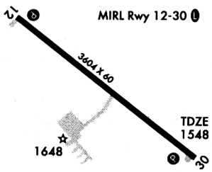
| A81-APT | ACTVT REIL RWY 12 & 30; PAPI RWY 12 & 30; MIRL RWY 12/30 - CTAF. |
Runways
Runway Summary
| Runways: | 12/30 |
| Longest Runway: | 12/30 is 3600 ft (1097 m) long |
| Runways with an Instrument Approach: |
KRUG Airport Runway Details
| Runway 12/30 | 3600 ft x 60 ft (1097 m x 18 m) | |
| Runway Length Source: | 3RD PARTY SURVEY as of 08/12/2008 | |
| Surface: | Asphalt - Fair condition - No special surface treatment | |
| Runway Edge Lights: | Medium Intensity | |
Runway Weight Bearing Capacity (in thousands of pounds) |
||
| Single Wheel Landing Gear: | 12.5 | |
Runway 12 |
Runway 30 |
|
Elevation: |
1533.6 | 1549.2 |
Latitude: |
48-23-36.3974N | 48-23-14.2611N |
Longitude: |
100-01-48.2804W | 100-01-06.5685W |
|
Runway True Alignment: |
129 | 309 |
Glide Path Angle: |
3.0 degrees | 3.0 degrees |
Runway Markings Type: |
Nonprecision Instrument | Nonprecision Instrument |
Runway Markings Condition: |
Good | Good |
Visual Glide Slope Indicators: |
2-Light PAPI On Left Side Of Runway | 2-Light PAPI On Left Side Of Runway |
REIL: |
Yes | Yes |
Threshold Crossing Height: |
28 | 43 |
Services
Airframe Repair: |
Major |
Powerplant Repair: |
Major |
Bottled Oxygen: |
None |
Bulk Oxygen: |
None |
Fuel Available: |
100LL, Jet A |
Landing Fees: |
No |
Parking: |
Tiedowns available |
Maps & Diagrams
KRUG Sectional
Flight Planning
at skyvector.com
at skyvector.com