Location
Latitude: |
48-06-59.7270N (48.116591) |
Longitude: |
098-54-35.9570W (-98.909988) |
Elevation: |
1469.4 feet MSL (448 m MSL) |
Magnetic Variation: |
4.2 E (as of April 2024 from WMM2020 model) |
Time Zone: |
UTC -6.0 (Standard Time) UTC -5.0 (Daylight Savings Time) |
From City: |
02 N.M. W of Devils Lake, North Dakota |
Found On: |
Twin Cities Chart |
FAA Region: |
AGL |
Contacts
Manager: |
Publicly owned: |
| SCOTT CRUSE 106 NATIONAL GUARD ST NW DEVILS LAKE, ND 58301-8993 701-662-5833 |
DEVILS LAKE AIRPORT AUTHORITY 106 NATIONAL GUARD ST NW DEVILS LAKE, ND 58301-8993 701-662-5833 |
Operations
Airport Status: |
Operational |
Facility Use: |
Public |
Type: |
Airport |
Control tower: |
No |
Attendance (Months/Days/Hours): |
Months/Days/Hours ALL/ALL/0700-1800 |
Boundary ARTCC: |
ZMP (Minneapolis) |
Responsible ARTCC: |
ZMP (Minneapolis) |
Lighting Schedule: |
SEE RMK |
Segmented Circle Indicator: |
No |
Traffic Pattern Altitude (MSL): |
2469 feet (753 m) |
NOTAMs Facility: |
DVL |
NOTAM-D Service: |
Yes |
International Airport of Entry: |
No |
Customs Landing Rights: |
No |
Military Landing Rights: |
Yes |
Civil/Military Joint Use: |
No |
Aircraft Rescue and Firefighting: |
Class I ARFF Index: A Air Carrier Service: Scheduled Certification Date: 01/2004 |
Based Aircraft
| Single Engine: | 24 |
| Multi Engine: | 3 |
| Jet Engine: | 1 |
Annual Operations (as of 12/31/2021)
| Total Operations: | 23780 | |
| Commercial: | 1230 | 5.2% |
| Air Taxi: | 2450 | 10.3% |
| GA Local: | 15000 | 63.1% |
| GA Itinerant: | 4700 | 19.8% |
| Military Aircraft: | 400 | 1.7% |
Communications
| CTAF: | 122.800 |
| Unicom: | 122.800 |
| AWOS-3PT: | 125.875 (701-662-7214) |
- COMMUNICATIONS PRVDD BY GRAND FORKS RADIO ON FREQ 122.3 (DEVILS LAKE RCO).
- APCH/DEP SVC PRVDD BY MINNEAPOLIS ARTCC (ZMP) ON FREQ 124.2/270.3 (WOODWORTH RCAG).
Fixed Based Operators (FBOs) & Fuel
(Click on a business for detail)
Please help us keep this information up to date. This is a FREE SERVICE just like everything else on Airport Guide! If you see that a business needs to be added, modified, or deleted please fill out our Update Form.
To add, modify, or delete a business click here.
Please help us keep this information up to date. This is a FREE SERVICE just like everything else on Airport Guide! If you see that a business needs to be added, modified, or deleted please fill out our Update Form.
Area Code: 701 |
| Business Name | Frequency | Phone | Fuel Grade |
|---|---|---|---|
| Devils Lake Aero Service
Website Update FBO info |
122.800 | 701-662-4416 | Jet A 100LL |
Flight Service Stations
| Primary | Alternate | |
| FSS on Field: | N | |
| FSS Name (ID): | Grand Forks(GFK) | |
| Frequency: | ||
| Toll Free Phone: | 1-800-WX-BRIEF |
Instrument Procedures / Charts
FAA Terminal Procedures valid from 0901Z 03/21/24 to 0901Z 04/18/24.
There are various types of charts available for an airport. They are listed in the Page Type column. Here is a legend for those types:
APD - Airport Diagram
DP - Departure Procedure Charts
HOT - Hot Spots
IAP - Instrument Approach Procedure Charts
MIN - Minimums
STAR - Standard Terminal Arrival Charts
| Page Type | Page Name | Volume | Action Since Last Cycle |
|---|---|---|---|
| APD | AIRPORT DIAGRAM | NC-1 | |
| IAP | ILS OR LOC RWY 31 | NC-1 | |
| IAP | RNAV (GPS) RWY 03 | NC-1 | |
| IAP | RNAV (GPS) RWY 13 | NC-1 | |
| IAP | RNAV (GPS) RWY 21 | NC-1 | |
| IAP | RNAV (GPS) RWY 31 | NC-1 | |
| MIN | ALTERNATE MINIMUMS | NC-1 | |
| MIN | TAKEOFF MINIMUMS | NC-1 |
Terminal Procedures are only available for airports in several countries with more being added all the time. If you are looking for a specific country's charts, please send an email to support(at)airportguide.com stating the country name. This will be used to prioritize the implementation.
Navigation Aids (Navaids) near DVL
| Dist (NM) | ID | Morse Code | Name | Type | Freq | True Hdg | Mag Hdg |
|---|---|---|---|---|---|---|---|
| 0.1 | DVL | _ . . . . . _ . _ . . | Devils Lake | VOR-DME | 114.75 | 230 | 226 |
| 61.1 | RDR | . _ . _ . . . _ . | Red River | TACAN | 116.40 | 98 | 94 |
| 69.9 | GFK | _ _ . . . _ . _ . _ | Grand Forks | VOR-DME | 114.30 | 97 | 93 |
| 71.3 | GF | _ _ . . . _ . | Hiser | NDB | 345 | 102 | 98 |
| 71.6 | JMS | . _ _ _ _ _ . . . | Jamestown | VOR-DME | 114.50 | 172 | 168 |
| 76.4 | JM | . _ _ _ _ _ | Sabon | NDB | 395 | 169 | 165 |
| 84.4 | HML | . . . . _ _ . _ . . | Humboldt | TACAN | 112.40 | 56 | 53 |
| 93.6 | CKN | _ . _ . _ . _ _ . | Crookston | NDB | 400 | 99 | 96 |
| 95.5 | MOT | _ _ _ _ _ _ | Minot | VOR-DME | 117.10 | 276 | 271 |
| 99.7 | MIB | _ _ . . _ . . . | Deering | TACAN | 114.90 | 281 | 276 |
Nearby Airports with Fuel
Notices to Airmen (NOTAMS)
Remarks
| A110-1 | NUMEROUS WATERFOWL & OTHER BIRDS; DEER & JACK RABBITS ON & INVOF ARPT. |
| A110-2 | FOR CD IF UNA TO CTC ON FSS FREQ, CTC MINNEAPOLIS ARTCC AT 651-463-5588. |
| A17 | FOR ATNDT AFT HRS CALL 701-520-0229. |
| A26 | 48 HRS PPR FOR UNSKED ACR OPS W/ MORE THAN 30 PSGRS CALL AMGR 701-662-5833. |
| A26 1 | SKED AIR CARRIER OPNS INVOLVING ACFT WITH MORE THAN 9 PSGRS ARE NOT AUTHORIZED IN EXCESS OF 15 MINS BFR OR AFT SKED ARR/DEP TIMES WO PRIOR COORD WTH ARPT MGR TO ENSURE THAT ARFF IS AVBL. |
| A30-03/21 | NOT AVBL FOR ACR WITH MORE THAN 9 PSGR SEATS. |
| A70-FUEL-A | FUEL AVBL IREG HRS CALL 701-520-0229; SELF SVC AVGAS AVBL H24. |
| A81-APT | ACTVT OR INCR INTST MALSR RWY 31; REIL RWY 03, 13, & 21; PAPI RWY 13/31; HIRL RWY 13/31, MIRL RWY 03/21 - CTAF. |
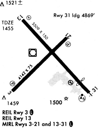
Runways
Runway Summary
| Runways: | 03/21 13/31 |
| Longest Runway: | 13/31 is 6400 ft (1951 m) long |
| Runways with an Instrument Approach: | 31 |
DVL Airport Runway Details
| Runway 03/21 | 4314 ft x 75 ft (1315 m x 23 m) | |
| Runway Length Source: | 3RD PARTY SURVEY as of 09/23/2021 | |
| Surface: | Asphalt - Good condition - No special surface treatment | |
| Runway Pavement Class: | 26 /F/D/W/T | |
| Runway Edge Lights: | Medium Intensity | |
Runway Weight Bearing Capacity (in thousands of pounds) |
||
| Single Wheel Landing Gear: | 30.0 | |
Runway 03 |
Runway 21 |
|
Elevation: |
1449.9 | 1441.0 |
Latitude: |
48-06-39.2476N | 48-07-09.3175N |
Longitude: |
098-54-53.0291W | 098-54-08.0279W |
|
Runway True Alignment: |
045 | 225 |
Glide Path Angle: |
3.0 degrees | 3.0 degrees |
Traffic Pattern: |
Left | Left |
Runway Markings Type: |
Nonprecision Instrument | Nonprecision Instrument |
Runway Markings Condition: |
Good | Good |
Object at End: |
ROAD | TREE |
Object Height: |
35 | 38 |
Distance from End: |
1119 | 1523 |
Object Centerline Offset: |
384 ft. left of centerline | 131 ft. right of centerline |
Visual Glide Slope Indicators: |
2-Light PAPI On Left Side Of Runway | 2-Light PAPI On Left Side Of Runway |
REIL: |
Yes | Yes |
Threshold Crossing Height: |
25 | 25 |
Declared Distances |
||
Take Off Run Avbl. (TORA): |
4314 | 4314 |
Take Off Distance Avbl. (TODA): |
4314 | 4314 |
Actual Stop Dist. Avbl. (ASDA): |
4314 | 4314 |
Landing Dist. Avbl. (LDA): |
4314 | 4314 |
| Runway 13/31 | 6400 ft x 100 ft (1951 m x 30 m) | |
| Runway Length Source: | 3RD PARTY SURVEY as of 09/23/2021 | |
| Surface: | Asphalt - Good condition - Saw-cut or plastic grooved | |
| Runway Pavement Class: | 27 /F/D/W/T | |
| Runway Edge Lights: | High Intensity | |
Runway Weight Bearing Capacity (in thousands of pounds) |
||
| Single Wheel Landing Gear: | 75.0 | |
| Dual Wheel Landing Gear: | 130.0 | |
| Dual Tandem Wheel Landing Gear: | 190.0 | |
Runway 13 |
Runway 31 |
|
Elevation: |
1469.4 | 1443.3 |
Latitude: |
48-07-26.8861N | 48-06-39.9030N |
Longitude: |
098-55-11.1327W | 098-54-08.1052W |
|
Runway True Alignment: |
138 | 318 |
ILS Type: |
ILS | |
Glide Path Angle: |
3.0 degrees | 3.0 degrees |
Runway Markings Type: |
Nonprecision Instrument | Precision Instrument |
Runway Markings Condition: |
Good | Good |
Object at End: |
BLDG | |
Object Height: |
29 | |
Distance from End: |
1400 | |
Object Centerline Offset: |
384 ft. left of centerline | 131 ft. right of centerline |
Visual Glide Slope Indicators: |
4-Light PAPI On Left Side Of Runway | 4-Light PAPI On Left Side Of Runway |
Approach Light System: |
1,400 Foot Medium Intensity Approach Lighting System With Runway Alignment Indicator Lights | |
REIL: |
Yes | |
Threshold Crossing Height: |
45 | 44 |
Declared Distances |
||
Take Off Run Avbl. (TORA): |
6401 | 6401 |
Take Off Distance Avbl. (TODA): |
6401 | 6401 |
Actual Stop Dist. Avbl. (ASDA): |
6401 | 6401 |
Landing Dist. Avbl. (LDA): |
6401 | 6401 |
Services
Airframe Repair: |
None |
Powerplant Repair: |
None |
Bottled Oxygen: |
None |
Bulk Oxygen: |
None |
Fuel Available: |
100LL |
Landing Fees: |
No |
Parking: |
Tiedowns available |
Maps & Diagrams
DVL Sectional
Flight Planning
at skyvector.com
at skyvector.com