Location
Latitude: |
48-53-03.9020N (48.884417) |
Longitude: |
099-37-15.3360W (-99.620927) |
Elevation: |
1822.6 feet MSL (556 m MSL) |
Magnetic Variation: |
4.8 E (as of April 2024 from WMM2020 model) |
Time Zone: |
UTC -6.0 (Standard Time) UTC -5.0 (Daylight Savings Time) |
From City: |
02 N.M. N of Rolla, North Dakota |
Found On: |
Twin Cities Chart |
FAA Region: |
AGL |
Contacts
Manager: |
Publicly owned: |
| GORDON KRECH 1104 6TH ST NE ROLLA, ND 58367 (701) 477-6780 |
ROLLA AIRPORT AUTHORITY 1104 6TH ST NE ROLLA, ND 58367 (701) 477-6780 |
Operations
Airport Status: |
Operational |
Facility Use: |
Public |
Type: |
Airport |
Activation Date: |
01/1947 |
Control tower: |
No |
Attendance (Months/Days/Hours): |
Months/Days/Hours ALL/ALL/ON CALL |
Boundary ARTCC: |
ZMP (Minneapolis) |
Responsible ARTCC: |
ZMP (Minneapolis) |
Lighting Schedule: |
SEE RMK |
Segmented Circle Indicator: |
No |
Traffic Pattern Altitude (MSL): |
2823 feet (860 m) |
NOTAMs Facility: |
GFK |
NOTAM-D Service: |
Yes |
International Airport of Entry: |
No |
Customs Landing Rights: |
No |
Military Landing Rights: |
No |
Civil/Military Joint Use: |
No |
Based Aircraft
| Single Engine: | 11 |
Annual Operations (as of 06/01/2020)
| Total Operations: | 4010 | |
| Air Taxi: | 410 | 10.2% |
| GA Local: | 2600 | 64.8% |
| GA Itinerant: | 1000 | 24.9% |
Communications
| CTAF: | 122.800 |
| Unicom: | 122.800 |
| AWOS-3: | 118.125 (701-477-0055) |
- APCH/DEP SVC PRVDD BY MINNEAPOLIS ARTCC ON FREQS 127.6/279.6 (MINOT RCAG).
- COMMUNICATIONS PRVDD BY GRAND FORKS RADIO ON FREQ 122.4 (ROLLA RCO).
Fixed Based Operators (FBOs) & Fuel
(Click on a business for detail)
Please help us keep this information up to date. This is a FREE SERVICE just like everything else on Airport Guide! If you see that a business needs to be added, modified, or deleted please fill out our Update Form.
To add, modify, or delete a business click here.
Please help us keep this information up to date. This is a FREE SERVICE just like everything else on Airport Guide! If you see that a business needs to be added, modified, or deleted please fill out our Update Form.
Area Code: 701 |
| Business Name | Frequency | Phone | Fuel Grade |
|---|---|---|---|
| Rolla Flying Service
Update FBO info |
Unicom 122.8 | 477-5145 | 100LL |
Flight Service Stations
| Primary | Alternate | |
| FSS on Field: | N | |
| FSS Name (ID): | Grand Forks(GFK) | |
| Frequency: | ||
| Toll Free Phone: | 1-800-WX-BRIEF |
Instrument Procedures / Charts
FAA Terminal Procedures valid from 0901Z 03/21/24 to 0901Z 04/18/24.
There are various types of charts available for an airport. They are listed in the Page Type column. Here is a legend for those types:
APD - Airport Diagram
DP - Departure Procedure Charts
HOT - Hot Spots
IAP - Instrument Approach Procedure Charts
MIN - Minimums
STAR - Standard Terminal Arrival Charts
| Page Type | Page Name | Volume | Action Since Last Cycle |
|---|---|---|---|
| IAP | RNAV (GPS) RWY 32 | NC-1 | |
| MIN | ALTERNATE MINIMUMS | NC-1 | |
| MIN | TAKEOFF MINIMUMS | NC-1 |
Terminal Procedures are only available for airports in several countries with more being added all the time. If you are looking for a specific country's charts, please send an email to support(at)airportguide.com stating the country name. This will be used to prioritize the implementation.
Navigation Aids (Navaids) near 06D
| Dist (NM) | ID | Morse Code | Name | Type | Freq | True Hdg | Mag Hdg |
|---|---|---|---|---|---|---|---|
| 54.1 | DVL | _ . . . . . _ . _ . . | Devils Lake | VOR-DME | 114.75 | 148 | 144 |
| 62.8 | YBR | _ . _ _ _ . . . . _ . | Brandon | VORTAC | 113.80 | 348 | 343 |
| 63.9 | BR | Brandon | NDB | 233 | 344 | 339 | |
| 74.7 | MIB | _ _ . . _ . . . | Deering | TACAN | 114.90 | 248 | 243 |
| 76.0 | MOT | _ _ _ _ _ _ | Minot | VOR-DME | 117.10 | 241 | 236 |
| 80.4 | PG | Portage | NDB | 353 | 43 | 39 | |
| 80.7 | YPG | Portage | VOR-DME | 114.60 | 40 | 36 | |
| 92.4 | UDE | Delta | NDB | 269 | 33 | 29 | |
| 98.6 | VLR | Langruth | VORTAC | 112.20 | 20 | 16 | |
| 98.8 | HML | . . . . _ _ . _ . . | Humboldt | TACAN | 112.40 | 89 | 85 |
Nearby Airports with Fuel
| Dist (NM) | Name (Airport IDs) | True Hdg | Mag Hdg | Fuel Grade |
|---|---|---|---|---|
| 16.0 | Rolette Airport (2H9) |
215 | 210 | 100lL |
| 31.6 | Bottineau Municipal Airport (D09) |
264 | 259 | 100LL |
| 33.7 | Rugby Municipal Airport (KRUG RUG) |
208 | 203 | 100LL, Jet A |
| 54.0 | Devils Lake Regional Airport (DVL KDVL DVL) |
148 | 144 | 100LL, Jet A |
| 62.9 | Brandon Municipal Airport (YBR CYBR CYBR) |
348 | 343 | 100LL, Jet A |
| 66.8 | Harvey Municipal Airport (5H4) |
190 | 185 | 100LL |
| 67.8 | Walhalla Municipal Airport (96D) |
86 | 83 | 100LL |
| 75.8 | Minot International Airport (MOT KMOT MOT) |
240 | 234 | 100LL, Jet A |
| 76.0 | Mohall Municipal Airport (KHBC HBC) |
265 | 259 | 100LL, Jet A |
| 78.8 | Cavalier Municipal Airport (2C8) |
93 | 90 | 100LL, Jet A |
| 93.7 | Hutson Field Airport (KGAF GAF) |
107 | 104 | 100LL, Jet A |
| 93.9 | Pembina Municipal Airport (PMB KPMB PMB) |
86 | 83 | 100LL |
| 96.8 | Kenmare Municipal Airport (7K5) |
263 | 256 | 100LL |
Notices to Airmen (NOTAMS)
Remarks
| A110-1 | FOR SNOW REMOVAL & ARPT CONDS CALL AMGR 701- 477-5145, 701- 477-6780 OR 701-477-0914. |
| A110-3 | RY 07/25 CLSD WINTER MONTHS (OCT-APR) DUE TO LACK OF SNOW REMOVAL. |
| A110-4 | WATERFOWL & BIRDS ON & INVOF AIRPORT. |
| A110-5 | FOR AWOS CALL 701-477-0055. |
| A110-6 | FOR CD IF UNA TO CTC ON FSS FREQ, CTC MINNEAPOLIS ARTCC AT 651-463-5588. |
| A16 | ADDNL PHONE CELL PHONE 701-550-9884 OR AL KRECH 701-477-0914. |
| A17 | FOR ATTENDANT CALL 701-550-9884 OR 701-477- 6780. |
| A70-FUEL-10 | 0LL 24 HOUR SELF SERVICE CREDIT CARD FUEL AVBL. |
| A81-APT | ACTVT MIRL RY 14/32 & PAPI RYS 14 & 32 - CTAF. |
| E111 | EXISTED PRIOR TO 1959. |
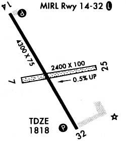
Runways
Runway Summary
| Runways: | 07/25 14/32 |
| Longest Runway: | 14/32 is 4300 ft (1311 m) long |
| Runways with an Instrument Approach: |
06D Airport Runway Details
| Runway 07/25 | 2200 ft x 75 ft (671 m x 23 m) | |
| Runway Length Source: | FAA OE/AAA as of 09/23/2019 | |
| Surface: | Turf - Good condition - No special surface treatment | |
Runway 07 |
Runway 25 |
|
Elevation: |
1820.8 | 1811.9 |
Latitude: |
48-52-59.9850N | 48-53-03.0680N |
Longitude: |
099-37-28.3554W | 099-36-55.7790W |
|
Runway True Alignment: |
082 | 262 |
Glide Path Angle: |
0.0 degrees | 0.0 degrees |
Traffic Pattern: |
Left | Left |
Object at End: |
ROAD | |
Object Height: |
18 | |
Distance from End: |
420 | |
Object Centerline Offset: |
167 ft. left and right of centerline |
| Runway 14/32 | 4300 ft x 75 ft (1311 m x 23 m) | |
| Runway Length Source: | 3RD PARTY SURVEY as of 10/18/2008 | |
| Surface: | Turf - Good condition - No special surface treatment | |
| Runway Edge Lights: | Medium Intensity | |
Runway Weight Bearing Capacity (in thousands of pounds) |
||
| Single Wheel Landing Gear: | 12.5 | |
Runway 14 |
Runway 32 |
|
Elevation: |
1822.6 | 1816.5 |
Latitude: |
48-53-23.4847N | 48-52-46.7497N |
Longitude: |
099-37-33.0969W | 099-37-00.9237W |
|
Runway True Alignment: |
150 | 330 |
Glide Path Angle: |
3.0 degrees | 3.0 degrees |
Traffic Pattern: |
Left | Left |
Runway Markings Type: |
Nonprecision Instrument | Nonprecision Instrument |
Runway Markings Condition: |
Fair | Fair |
Object at End: |
ROAD | TREES |
Object Height: |
15 | 50 |
Distance from End: |
800 | 1270 |
Object Centerline Offset: |
167 ft. left and right of centerline | |
Visual Glide Slope Indicators: |
2-Light PAPI On Left Side Of Runway | 2-Light PAPI On Left Side Of Runway |
Threshold Crossing Height: |
27 | 27 |
Services
Bottled Oxygen: |
None |
Bulk Oxygen: |
None |
Fuel Available: |
100LL |
Landing Fees: |
No |
Parking: |
Tiedowns available |
Maps & Diagrams
06D Sectional
Flight Planning
at skyvector.com
at skyvector.com