Location
Latitude: |
35-57-04.6490N (35.951291) |
Longitude: |
085-05-05.9180W (-85.084977) |
Elevation: |
1881.7 feet MSL (574 m MSL) |
Magnetic Variation: |
5.3 W (as of May 2024 from WMM2020 model) |
Time Zone: |
UTC -6.0 (Standard Time) UTC -5.0 (Daylight Savings Time) |
From City: |
03 N.M. W of Crossville, Tennessee |
Found On: |
Atlanta Chart |
FAA Region: |
ASO |
Contacts
Manager: |
Publicly owned: |
| GREG LIVINGSTON 2409 SPARTA HIGHWAY CROSSVILLE, TN 38555 931-484-5278 |
CITY OF CROSSVILLE 392 NORTH MAIN CROSSVILLE, TN 38555 931-484-5278 |
Operations
Airport Status: |
Operational |
Facility Use: |
Public |
Type: |
Airport |
Activation Date: |
05/1941 |
Control tower: |
No |
Attendance (Months/Days/Hours): |
Months/Days/Hours ALL/ALL/0800-DARK |
Boundary ARTCC: |
ZTL (Atlanta) |
Responsible ARTCC: |
ZTL (Atlanta) |
Lighting Schedule: |
SEE RMK |
Segmented Circle Indicator: |
Yes |
Traffic Pattern Altitude (MSL): |
2882 feet (878 m) |
NOTAMs Facility: |
CSV |
NOTAM-D Service: |
Yes |
International Airport of Entry: |
No |
Customs Landing Rights: |
No |
Military Landing Rights: |
Yes |
Civil/Military Joint Use: |
No |
Based Aircraft
| Single Engine: | 37 |
| Multi Engine: | 2 |
Annual Operations (as of 08/29/2017)
| Total Operations: | 28550 | |
| Air Taxi: | 110 | 0.4% |
| GA Local: | 15000 | 52.5% |
| GA Itinerant: | 13140 | 46.0% |
| Military Aircraft: | 300 | 1.1% |
Communications
| CTAF: | 122.700 |
| Unicom: | 122.700 |
| ASOS: | 120.625 (931-456-4406) |
- APCH/DEP SVC PRVDD BY ATLANTA ARTCC ON FREQS 133.6/254.3 (HINCH MOUNTAIN RCAG).
Fixed Based Operators (FBOs) & Fuel
(Click on a business for detail)
Please help us keep this information up to date. This is a FREE SERVICE just like everything else on Airport Guide! If you see that a business needs to be added, modified, or deleted please fill out our Update Form.
To add, modify, or delete a business click here.
Please help us keep this information up to date. This is a FREE SERVICE just like everything else on Airport Guide! If you see that a business needs to be added, modified, or deleted please fill out our Update Form.
Area Code: 931 |
| Business Name | Frequency | Phone | Fuel Grade |
|---|---|---|---|
| Crossville Flying Service
Update FBO info |
484-5016 | 100LL, Jet A |
Flight Service Stations
| Primary | Alternate | |
| FSS on Field: | N | |
| FSS Name (ID): | Nashville(BNA) | |
| Frequency: | ||
| Toll Free Phone: | 1-800-WX-BRIEF |
Instrument Procedures / Charts
FAA Terminal Procedures valid from 0901Z 03/21/24 to 0901Z 04/18/24.
There are various types of charts available for an airport. They are listed in the Page Type column. Here is a legend for those types:
APD - Airport Diagram
DP - Departure Procedure Charts
HOT - Hot Spots
IAP - Instrument Approach Procedure Charts
MIN - Minimums
STAR - Standard Terminal Arrival Charts
| Page Type | Page Name | Volume | Action Since Last Cycle |
|---|---|---|---|
| IAP | ILS Y OR LOC Y RWY 26 | SE-1 | |
| IAP | ILS Z OR LOC Z RWY 26 | SE-1 | |
| IAP | RNAV (GPS) RWY 26 | SE-1 | |
| IAP | VOR-A | SE-1 | |
| MIN | ALTERNATE MINIMUMS | SE-1 | |
| MIN | TAKEOFF MINIMUMS | SE-1 |
Terminal Procedures are only available for airports in several countries with more being added all the time. If you are looking for a specific country's charts, please send an email to support(at)airportguide.com stating the country name. This will be used to prioritize the implementation.
Navigation Aids (Navaids) near CSV
| Dist (NM) | ID | Morse Code | Name | Type | Freq | True Hdg | Mag Hdg |
|---|---|---|---|---|---|---|---|
| 11.5 | HCH | . . . . _ . _ . . . . . | Hinch Mountain | VOR-DME | 117.60 | 153 | 158 |
| 24.4 | HEM | . . . . . _ _ | Huchn | NDB | 233 | 275 | 280 |
| 29.1 | DTE | _ . . _ . | Mark Anton | NDB | 394 | 165 | 170 |
| 35.1 | RN | . _ . _ . | Warri | NDB | 209 | 250 | 255 |
| 35.2 | SKN | . . . _ . _ _ . | Hurricane | NDB | 256 | 273 | 278 |
| 38.2 | LVT | . _ . . . . . _ _ | Livingston | VOR-DME | 114.35 | 354 | 359 |
| 42.0 | MNV | _ _ _ . . . . _ | Madisonville | NDB | 361 | 125 | 131 |
| 42.0 | MMI | _ _ _ _ . . | Mc Minn County | NDB | 242 | 142 | 147 |
| 46.0 | BPO | _ . . . . _ _ . _ _ _ | Piney Grove | NDB | 403 | 39 | 45 |
| 47.2 | CQN | _ . _ . _ _ . _ _ . | Daisy | NDB | 341 | 184 | 189 |
| 48.6 | HDI | . . . . _ . . . . | Hardwick | NDB | 369 | 169 | 174 |
| 53.6 | TYS | _ _ . _ _ . . . | Knoxville | VOT | 112.00 | 98 | 104 |
| 57.9 | VXV | . . . _ _ . . _ . . . _ | Volunteer | VORTAC | 116.40 | 92 | 98 |
| 58.8 | APT | . _ . _ _ . _ | Jasper | NDB | 382 | 204 | 209 |
| 59.5 | GQO | _ _ . _ _ . _ _ _ _ | Choo Choo | DME | 115.8 | 183 | 188 |
| 61.3 | JUE | . _ _ _ . . _ . | Lebanon | NDB | 414 | 283 | 288 |
| 62.5 | FQW | . . _ . _ _ . _ . _ _ | Walter Hill | NDB | 371 | 270 | 275 |
| 63.6 | ULH | . . _ . _ . . . . . . | Burwi | NDB | 332 | 242 | 247 |
| 65.7 | CDX | _ . _ . _ . . _ . . _ | Cumberland River | NDB | 388 | 17 | 23 |
| 66.1 | UXM | . . _ _ . . _ _ _ | Tullahoma Regional | VOR | 109.65 | 239 | 244 |
Nearby Airports with Fuel
Notices to Airmen (NOTAMS)
Remarks
| A110-1 | FOR CD IF UNA TO CTC ON FSS FREQ, CTC ATLANTA ARTCC AT 770-210-7692. |
| A17 | CLSD THANKSGIVING & CHRISTMAS. |
| A17 1 | AFT HR - 931-267-5214. |
| A43-26 | PAPI UNUSBL BYD 8 DEGS RIGHT OF CNTRLN. |
| A81-APT | HIRL RWY 08/26 PRESET LOW INTST; INCR INTST - CTAF. |
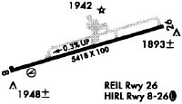
Runways
Runway Summary
| Runways: | 08/26 |
| Longest Runway: | 08/26 is 5423 ft (1653 m) long |
| Runways with an Instrument Approach: | 26 |
CSV Airport Runway Details
| Runway 08/26 | 5423 ft x 100 ft (1653 m x 30 m) | |
| Runway Length Source: | 3RD PARTY SURVEY as of 09/15/2021 | |
| Surface: | Asphalt - Good condition - No special surface treatment | |
| Runway Pavement Class: | 22 /F/D/X/T | |
| Runway Edge Lights: | High Intensity | |
Runway Weight Bearing Capacity (in thousands of pounds) |
||
| Single Wheel Landing Gear: | 33.0 | |
| Dual Wheel Landing Gear: | 62.0 | |
Runway 08 |
Runway 26 |
|
Elevation: |
1880.9 | 1866.9 |
Latitude: |
35-56-57.0152N | 35-57-12.2806N |
Longitude: |
085-05-37.5257W | 085-04-34.3091W |
|
Runway True Alignment: |
073 | 253 |
ILS Type: |
ILS | |
Glide Path Angle: |
3.0 degrees | 3.0 degrees |
Traffic Pattern: |
Left | Left |
Runway Markings Type: |
Precision Instrument | Precision Instrument |
Runway Markings Condition: |
Good | Good |
Visual Glide Slope Indicators: |
4-Box VASI On Right Side Of Runway | 4-Light PAPI On Left Side Of Runway |
REIL: |
Yes | |
Threshold Crossing Height: |
50 | 60 |
Services
Airframe Repair: |
Minor |
Powerplant Repair: |
Minor |
Fuel Available: |
100LL, Jet A+ |
Landing Fees: |
No |
Parking: |
Hangars and tiedowns available |
Maps & Diagrams
CSV Sectional
Flight Planning
at skyvector.com
at skyvector.com