Location
Latitude: |
36-20-02.7200N (36.334089) |
Longitude: |
084-09-46.6750W (-84.162965) |
Elevation: |
1179.9 feet MSL (360 m MSL) |
Magnetic Variation: |
6 W (as of April 2024 from WMM2020 model) |
Time Zone: |
UTC -5.0 (Standard Time) UTC -4.0 (Daylight Savings Time) |
From City: |
01 N.M. E of Jacksboro, Tennessee |
Found On: |
Cincinnati Chart |
FAA Region: |
ASO |
Contacts
Manager: |
Publicly owned: |
| BERT LOUPE 610 MEMORIAL LANE JACKSBORO, TN 37757 423-562-9966 |
CAMPBELL COUNTY COUNTY COURTHOUSE, PO BOX 435 JACKSBORO, TN 37757 423-562-2526 |
Operations
Airport Status: |
Operational |
Facility Use: |
Public |
Type: |
Airport |
Control tower: |
No |
Attendance (Months/Days/Hours): |
Months/Days/Hours ALL/MON-FRI/0900-1700 |
Boundary ARTCC: |
ZTL (Atlanta) |
Responsible ARTCC: |
ZTL (Atlanta) |
Lighting Schedule: |
SEE RMK |
Segmented Circle Indicator: |
Yes |
Traffic Pattern Altitude (MSL): |
2180 feet (664 m) |
NOTAMs Facility: |
BNA |
NOTAM-D Service: |
Yes |
International Airport of Entry: |
No |
Customs Landing Rights: |
No |
Military Landing Rights: |
Yes |
Civil/Military Joint Use: |
No |
Based Aircraft
| Single Engine: | 6 |
| Multi Engine: | 2 |
| GA Helicopters: | 1 |
Annual Operations (as of 07/26/2021)
| Total Operations: | 6200 | |
| GA Local: | 4300 | 69.4% |
| GA Itinerant: | 1800 | 29.0% |
| Military Aircraft: | 100 | 1.6% |
Communications
| CTAF: | 122.800 |
| Unicom: | 122.800 |
| AWOS-3: | 124.975 (423-566-6474) |
- APCH/DEP SVC PRVDD BY ATLANTA ARTCC ON FREQS 133.6/254.3 (HINCH MOUNTAIN RCAG).
Fixed Based Operators (FBOs) & Fuel
(Click on a business for detail)
Please help us keep this information up to date. This is a FREE SERVICE just like everything else on Airport Guide! If you see that a business needs to be added, modified, or deleted please fill out our Update Form.
To add, modify, or delete a business click here.
Please help us keep this information up to date. This is a FREE SERVICE just like everything else on Airport Guide! If you see that a business needs to be added, modified, or deleted please fill out our Update Form.
Area Code: 423 |
| Business Name | Frequency | Phone | Fuel Grade |
|---|---|---|---|
| Campbell County Aviation
Update FBO info |
Unicom 122.8 | 562-9966 | 100LL |

|
Chevron |
100LL - 2.60 USD per gallon on 3/26/02 |
Non 24-Hour Self-Serve Pumps |
Flight Service Stations
| Primary | Alternate | |
| FSS on Field: | N | |
| FSS Name (ID): | Nashville(BNA) | |
| Frequency: | ||
| Toll Free Phone: | 1-800-WX-BRIEF |
Instrument Procedures / Charts
FAA Terminal Procedures valid from 0901Z 03/21/24 to 0901Z 04/18/24.
There are various types of charts available for an airport. They are listed in the Page Type column. Here is a legend for those types:
APD - Airport Diagram
DP - Departure Procedure Charts
HOT - Hot Spots
IAP - Instrument Approach Procedure Charts
MIN - Minimums
STAR - Standard Terminal Arrival Charts
| Page Type | Page Name | Volume | Action Since Last Cycle |
|---|---|---|---|
| IAP | RNAV (GPS) RWY 23 | SE-1 | |
| MIN | TAKEOFF MINIMUMS | SE-1 |
Terminal Procedures are only available for airports in several countries with more being added all the time. If you are looking for a specific country's charts, please send an email to support(at)airportguide.com stating the country name. This will be used to prioritize the implementation.
Navigation Aids (Navaids) near KJAU
| Dist (NM) | ID | Morse Code | Name | Type | Freq | True Hdg | Mag Hdg |
|---|---|---|---|---|---|---|---|
| 19.5 | BPO | _ . . . . _ _ . _ _ _ | Piney Grove | NDB | 403 | 309 | 315 |
| 28.9 | VXV | . . . _ _ . . _ . . . _ | Volunteer | VORTAC | 116.40 | 153 | 159 |
| 32.1 | TYS | _ _ . _ _ . . . | Knoxville | VOT | 112.00 | 165 | 171 |
| 35.9 | JXT | . _ _ _ _ . . _ _ | Jefferson | NDB | 346 | 111 | 117 |
| 42.0 | LOZ | . _ . . _ _ _ _ _ . . | London | VOR-DME | 116.55 | 3 | 9 |
| 46.9 | CDX | _ . _ . _ . . _ . . _ | Cumberland River | NDB | 388 | 328 | 334 |
| 48.5 | MNV | _ _ _ . . . . _ | Madisonville | NDB | 361 | 192 | 198 |
| 50.7 | LVT | . _ . . . . . _ _ | Livingston | VOR-DME | 114.35 | 287 | 293 |
| 51.6 | HCH | . . . . _ . _ . . . . . | Hinch Mountain | VOR-DME | 117.60 | 230 | 236 |
| 59.6 | MMI | _ _ _ _ . . | Mc Minn County | NDB | 242 | 199 | 205 |
| 62.2 | RVN | . _ . . . . _ _ . | Rogersville | NDB | 329 | 82 | 88 |
| 62.7 | DYQ | _ . . _ . _ _ _ _ . _ | Dulaney | NDB | 263 | 100 | 106 |
| 63.0 | SOT | . . . _ _ _ _ | Snowbird | VORTAC | 108.80 | 120 | 126 |
| 63.3 | DTE | _ . . _ . | Mark Anton | NDB | 394 | 216 | 222 |
| 72.0 | HEM | . . . . . _ _ | Huchn | NDB | 233 | 253 | 259 |
| 76.7 | AZQ | . _ _ _ . . _ _ . _ | Hazard | DME | 111.2 | 33 | 39 |
| 79.5 | HDI | . . . . _ . . . . | Hardwick | NDB | 369 | 207 | 213 |
| 79.9 | DVK | _ . . . . . _ _ . _ | Goodall | NDB | 311 | 339 | 345 |
| 80.6 | BO | _ . . . _ _ _ | Booie | NDB | 221 | 86 | 93 |
| 82.4 | SKN | . . . _ . _ _ . | Hurricane | NDB | 256 | 255 | 260 |
Nearby Airports with Fuel
Notices to Airmen (NOTAMS)
Remarks
| A110-4 | HIGH TRRN S THRU NE. |
| A110-6 | DEER & COYOTE OCNLY ON RWY. |
| A110-7 | FOR CD CTC ATLANTA ARTCC AT 770-210-7692. |
| A81-APT | ACTVT REIL RWY 5 & 23; MIRL RWY 5/23 - CTAF. PAPI RWY 05 & 23 ON CONSLY. |
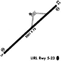
Runways
Runway Summary
| Runways: | 05/23 |
| Longest Runway: | 05/23 is 4000 ft (1219 m) long |
| Runways with an Instrument Approach: |
KJAU Airport Runway Details
| Runway 05/23 | 4000 ft x 75 ft (1219 m x 23 m) | |
| Runway Length Source: | OWNER as of 02/20/2006 | |
| Surface: | Asphalt - Good condition - No special surface treatment | |
| Runway Edge Lights: | Medium Intensity | |
Runway Weight Bearing Capacity (in thousands of pounds) |
||
| Single Wheel Landing Gear: | 25.0 | |
Runway 05 |
Runway 23 |
|
Elevation: |
1133.7 | 1179.9 |
Latitude: |
36-19-48.8900N | 36-20-16.5500N |
Longitude: |
084-10-04.1800W | 084-09-29.1700W |
|
Runway True Alignment: |
046 | 226 |
Glide Path Angle: |
3.0 degrees | 3.0 degrees |
Traffic Pattern: |
Left | Left |
Runway Markings Type: |
Basic | Basic |
Runway Markings Condition: |
Good | Good |
Object at End: |
TREES | |
Object Height: |
45 | |
Distance from End: |
943 | |
Object Centerline Offset: |
190 ft. right of centerline | |
Visual Glide Slope Indicators: |
2-Light PAPI On Left Side Of Runway | 2-Light PAPI On Left Side Of Runway |
REIL: |
Yes | Yes |
Touchdown Lights: |
No | No |
Centerline Lights: |
No | No |
Threshold Crossing Height: |
26 | 30 |
Services
Fuel Available: |
100LL, Jet A+ |
Landing Fees: |
Yes |
Parking: |
Hangars and tiedowns available |
Maps & Diagrams
KJAU Sectional
Flight Planning
at skyvector.com
at skyvector.com