Location
Latitude: |
41-46-40.1960N (41.777832) |
Longitude: |
080-54-14.3270W (-80.90398) |
Elevation: |
820.0 feet MSL (250 m MSL) |
Magnetic Variation: |
8.9 W (as of April 2024 from WMM2020 model) |
Time Zone: |
UTC -5.0 (Standard Time) UTC -4.0 (Daylight Savings Time) |
From City: |
03 N.M. SE of Geneva, Ohio |
Found On: |
Detroit Chart |
FAA Region: |
AGL |
Contacts
Manager: |
Privately owned: |
| ALAN KETTUNEN 4180 CLAY ST GENEVA, OH 44041-9268 440-645-1982 |
JOHN WILLIAMS 1419 STATE ROUTE 45 AUSTINBURG, OH 44010-9749 440-275-3205 |
Operations
Airport Status: |
Operational |
Facility Use: |
Public |
Type: |
Airport |
Activation Date: |
09/1959 |
Control tower: |
No |
Attendance (Months/Days/Hours): |
Months/Days/Hours ALL/ALL/0830-1700 |
Boundary ARTCC: |
ZOB (Cleveland) |
Responsible ARTCC: |
ZOB (Cleveland) |
Lighting Schedule: |
SS-SR |
Segmented Circle Indicator: |
Yes |
Traffic Pattern Altitude (MSL): |
1820 feet (555 m) |
NOTAMs Facility: |
CLE |
NOTAM-D Service: |
Yes |
International Airport of Entry: |
No |
Customs Landing Rights: |
No |
Military Landing Rights: |
No |
Civil/Military Joint Use: |
No |
Based Aircraft
| Single Engine: | 20 |
| Multi Engine: | 2 |
| Jet Engine: | 2 |
| Ultralights: | 2 |
Annual Operations (as of 09/09/2022)
| Total Operations: | 1206 | |
| GA Local: | 1000 | 82.9% |
| GA Itinerant: | 200 | 16.6% |
| Military Aircraft: | 6 | 0.5% |
Communications
| CTAF: | 122.900 |
- APCH/DEP SVC PRVDD BY CLEVELAND ARTCC (ZOB) ON 120.775/298.95 (CHARDON RCAG).
Fixed Based Operators (FBOs) & Fuel
(Click on a business for detail)
Please help us keep this information up to date. This is a FREE SERVICE just like everything else on Airport Guide! If you see that a business needs to be added, modified, or deleted please fill out our Update Form.
To add, modify, or delete a business click here.
Please help us keep this information up to date. This is a FREE SERVICE just like everything else on Airport Guide! If you see that a business needs to be added, modified, or deleted please fill out our Update Form.
Area Code: 216 |
| Business Name | Frequency | Phone | Fuel Grade |
|---|---|---|---|
| Germack Enterprises
Update FBO info |
466-2401 | ||
| Germack Vehicle Refinishing
Update FBO info |
466-2401 |
Flight Service Stations
| Primary | Alternate | |
| FSS on Field: | N | |
| FSS Name (ID): | Cleveland(CLE) | |
| Frequency: | ||
| Toll Free Phone: | 1-800-WX-BRIEF |
Instrument Procedures / Charts
Terminal Procedures are only available for airports in several countries with more being added all the time. If you are looking for a specific country's charts, please send an email to support(at)airportguide.com stating the country name. This will be used to prioritize the implementation.
Navigation Aids (Navaids) near 7D9
| Dist (NM) | ID | Morse Code | Name | Type | Freq | True Hdg | Mag Hdg |
|---|---|---|---|---|---|---|---|
| 7.1 | JFN | . _ _ _ . . _ . _ . | Jefferson | DME | 115.2 | 98 | 107 |
| 19.5 | CXR | _ . _ . _ . . _ . _ . | Chardon | VOR-DME | 112.70 | 216 | 225 |
| 22.0 | LQL | . _ . . _ _ . _ . _ . . | Lakeland | NDB | 263 | 255 | 264 |
| 28.7 | YNG | _ . _ _ _ . _ _ . | Youngstown | VORTAC | 109.00 | 158 | 167 |
| 30.9 | ERI | . . _ . . . | Erie | TACAN | 109.40 | 62 | 71 |
| 32.9 | ERI | . . _ . . . | Esmer | NDB | 349 | 61 | 70 |
| 37.3 | YN | _ . _ _ _ . | Fetch | NDB | 338 | 158 | 167 |
| 41.1 | HBD | . . . . _ . . . _ . . | Hubbard | NDB | 408 | 155 | 164 |
| 41.1 | CQD | _ . _ . _ _ . _ _ . . | Cascade | NDB | 372 | 59 | 68 |
| 42.4 | ACO | . _ _ . _ . _ _ _ | Akron | VOR-DME | 114.40 | 198 | 207 |
| 47.6 | CLE | _ . _ . . _ . . . | Cleveland | VOT | 110.40 | 243 | 252 |
| 47.7 | AK | . _ _ . _ | Akron | NDB | 362 | 207 | 216 |
| 50.3 | UCP | . . _ _ . _ . . _ _ . | Castle | NDB | 272 | 153 | 162 |
| 51.2 | FKL | . . _ . _ . _ . _ . . | Franklin | VOR | 109.60 | 113 | 122 |
| 56.7 | ORJ | _ _ _ . _ . . _ _ _ | Corry | NDB | 258 | 81 | 90 |
| 57.1 | CAK | _ . _ . . _ _ . _ | Akron/Canton Regional | VOT | 110.60 | 205 | 214 |
| 60.3 | 7B | St Thomas | NDB | 375 | 351 | 360 | |
| 61.3 | 4L | Chatham | NDB | 236 | 301 | 310 | |
| 61.8 | DJB | _ . . . _ _ _ _ . . . | Dryer | VOR-DME | 113.60 | 246 | 254 |
| 65.1 | EWC | . . _ _ _ . _ . | Ellwood City | VOR-DME | 115.80 | 151 | 160 |
Nearby Airports with Fuel
Notices to Airmen (NOTAMS)
Remarks
| A110-1 | DEER ON & INVOF ARPT. |
| A110-10 | ACFT PARKED WI RESA, AER 19, 33 FT RIGHT OF CNTRLN. |
| A110-3 | NO LINE OF SIGHT BTN RWY ENDS. |
| A110-6 | FOR CD CTC BUFFALO APCH AT 716-626-6920, WHEN APCH CLSD CTC CLEVELAND ARTCC AT 440-774-0232/0490. |
| A110-8 | RWY 19: 15 FT ROAD, 32 FT FM RWY END. |
| A110-9 | RWY 01: -10 FT DITCH/CREEK AT RWY END. |
| A14 | ALANKETTUNEN@WINDSTREAM.NET. |
| A33-01/19 | HIGHLY DETERIORATED; PAVEMENT ROUGH & UNEVEN ROLLING SFC; NMRS CRACKS, PATCHES, LOOSE AGGREGATE, & FOD. |
| A40-01/19 | SOLAR LED LIGHTS, SPACING NSTD. |
| A42-01 | FADED. |
| A42-01 1 | NSTD BASIC DUE TO SPACING & SIZE. |
| A42-19 | FADED. |
| A42-19 1 | NSTD BASIC DUE TO SPACING & SIZE. |
| A52-19 | +35 FT PLINE; +78 FT TREES NORTH OF RD. |
| A58-01 | RWY 01 60 FT TREES 0 FT FR 125 FT EACH SIDE OF RWY CNTRLN EXTDNG 200 FT FR. |
| A58-19 | 15 FT ROAD, 32 FT DSTC; 35 FT PLINE, 70 FT DSTC, 0 B; GRADE CHGS & 80 FT TREES 79-199 FT DSTC, 0-125 15 FT R. |
| A70-FUEL-10 | 0LL 100LL AVBL AFT ATNDD HRS BY APNTMT. |
| E111 | VFR OPS ONLY. |
Runways
Runway Summary
| Runways: | 01/19 |
| Longest Runway: | 01/19 is 3260 ft (994 m) long |
| Runways with an Instrument Approach: |
7D9 Airport Runway Details
| Runway 01/19 | 3260 ft x 28 ft (994 m x 9 m) | |
| Runway Length Source: | FAA-EST as of 07/17/2001 | |
| Surface: | Asphalt - Poor condition - No special surface treatment | |
| Runway Edge Lights: | Non-standard lighting system Intensity | |
Runway 01 |
Runway 19 |
|
Elevation: |
820.0 | 820.0 |
Latitude: |
41-46-24.1100N | 41-46-56.2600N |
Longitude: |
080-54-15.6300W | 080-54-13.0000W |
|
Runway True Alignment: |
004 | 184 |
Glide Path Angle: |
0.0 degrees | 0.0 degrees |
Traffic Pattern: |
Left | Left |
Runway Markings Type: |
Nonstandard (other than numbers only) | Nonstandard (other than numbers only) |
Runway Markings Condition: |
Poor | Poor |
Object at End: |
TREE | TREES |
Object Height: |
46 | 80 |
Distance from End: |
224 | 201 |
Object Centerline Offset: |
63 ft. left of centerline | 15 ft. right of centerline |
REIL: |
No | No |
Touchdown Lights: |
No | No |
Centerline Lights: |
No | No |
Services
Airframe Repair: |
None |
Bottled Oxygen: |
None |
Bulk Oxygen: |
None |
Fuel Available: |
100LL |
Landing Fees: |
No |
Parking: |
Tiedowns available |
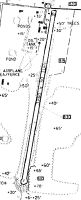
Maps & Diagrams
7D9 Sectional
Flight Planning
at skyvector.com
at skyvector.com