Location
Latitude: |
40-56-53.0910N (40.948081) |
Longitude: |
080-51-43.4950W (-80.862082) |
Elevation: |
1162.0 feet MSL (354 m MSL) |
Magnetic Variation: |
8.8 W (as of April 2024 from WMM2020 model) |
Time Zone: |
UTC -5.0 (Standard Time) UTC -4.0 (Daylight Savings Time) |
From City: |
03 N.M. N of Salem, Ohio |
Found On: |
Detroit Chart |
FAA Region: |
AGL |
Contacts
Manager: |
Privately owned: |
| VICK SURACI 11718 SALEM WARREN RD SALEM, OH 44460-9667 724-316-6026 |
SALEM AIRPARK LLC 970 WINDHAM CT STE 7 BOARDMAN, OH 44512-5082 330-726-6385 |
Operations
Airport Status: |
Operational |
Facility Use: |
Public |
Type: |
Airport |
Activation Date: |
10/1952 |
Control tower: |
No |
Attendance (Months/Days/Hours): |
Months/Days/Hours IREG |
Boundary ARTCC: |
ZOB (Cleveland) |
Responsible ARTCC: |
ZOB (Cleveland) |
Lighting Schedule: |
SEE RMK |
Segmented Circle Indicator: |
No |
Traffic Pattern Altitude (MSL): |
2162 feet (659 m) |
NOTAMs Facility: |
CLE |
NOTAM-D Service: |
Yes |
International Airport of Entry: |
No |
Customs Landing Rights: |
No |
Military Landing Rights: |
No |
Civil/Military Joint Use: |
No |
Based Aircraft
| Single Engine: | 58 |
Annual Operations (as of 10/25/2023)
| Total Operations: | 5800 | |
| GA Local: | 5400 | 93.1% |
| GA Itinerant: | 400 | 6.9% |
Communications
| CTAF: | 122.700 |
| Unicom: | 122.700 |
| Approach: | CLEVELAND 125.5 125.5 CLEVELAND ARTCC |
| Departure: | CLEVELAND 125.5 125.5 CLEVELAND ARTCC |
- APCH/DEP SVC PRVDD BY CLEVELAND APCH (CLE) 0600-0100. APCH/DEP SVC PRVDD BY CLEVELAND ARTCC (ZOB) ON FREQS 120.6/379.275 (MOUNT HOPE RCAG) 0100-0600.
Fixed Based Operators (FBOs) & Fuel
(Click on a business for detail)
Please help us keep this information up to date. This is a FREE SERVICE just like everything else on Airport Guide! If you see that a business needs to be added, modified, or deleted please fill out our Update Form.
To add, modify, or delete a business click here.
Please help us keep this information up to date. This is a FREE SERVICE just like everything else on Airport Guide! If you see that a business needs to be added, modified, or deleted please fill out our Update Form.
Area Code: 330 |
| Business Name | Frequency | Phone | Fuel Grade |
|---|---|---|---|
| Seidner Aviation
Update FBO info |
Unicom 122.7 | 332-4400 |
Flight Service Stations
| Primary | Alternate | |
| FSS on Field: | N | |
| FSS Name (ID): | Cleveland(CLE) | |
| Frequency: | ||
| Toll Free Phone: | 1-800-WX-BRIEF |
Instrument Procedures / Charts
FAA Terminal Procedures valid from 0901Z 03/21/24 to 0901Z 04/18/24.
There are various types of charts available for an airport. They are listed in the Page Type column. Here is a legend for those types:
APD - Airport Diagram
DP - Departure Procedure Charts
HOT - Hot Spots
IAP - Instrument Approach Procedure Charts
MIN - Minimums
STAR - Standard Terminal Arrival Charts
| Page Type | Page Name | Volume | Action Since Last Cycle |
|---|---|---|---|
| IAP | RNAV (GPS)-A | EC-2 | |
| MIN | TAKEOFF MINIMUMS | EC-2 |
Terminal Procedures are only available for airports in several countries with more being added all the time. If you are looking for a specific country's charts, please send an email to support(at)airportguide.com stating the country name. This will be used to prioritize the implementation.
Navigation Aids (Navaids) near 38D
| Dist (NM) | ID | Morse Code | Name | Type | Freq | True Hdg | Mag Hdg |
|---|---|---|---|---|---|---|---|
| 18.1 | ACO | . _ _ . _ . _ _ _ | Akron | VOR-DME | 114.40 | 302 | 311 |
| 19.3 | YN | _ . _ _ _ . | Fetch | NDB | 338 | 38 | 47 |
| 19.4 | HBD | . . . . _ . . . _ . . | Hubbard | NDB | 408 | 50 | 59 |
| 20.7 | UCP | . . _ _ . _ . . _ _ . | Castle | NDB | 272 | 77 | 86 |
| 24.5 | YNG | _ . _ _ _ . _ _ . | Youngstown | VORTAC | 109.00 | 20 | 29 |
| 24.9 | AK | . _ _ . _ | Akron | NDB | 362 | 287 | 296 |
| 26.4 | CAK | _ . _ . . _ _ . _ | Akron/Canton Regional | VOT | 110.60 | 266 | 275 |
| 28.7 | BSV | _ . . . . . . . . . _ | Briggs | VOR-DME | 112.40 | 244 | 253 |
| 30.4 | EWC | . . _ _ _ . _ . | Ellwood City | VOR-DME | 115.80 | 103 | 112 |
| 36.7 | CXR | _ . _ . _ . . _ . _ . | Chardon | VOR-DME | 112.70 | 338 | 347 |
| 41.1 | MMJ | _ _ _ _ . _ _ _ | Montour | DME | 112 | 132 | 141 |
| 43.2 | CFX | _ . _ . . . _ . _ . . _ | Cadiz | NDB | 239 | 189 | 198 |
| 43.4 | HLG | . . . . . _ . . _ _ . | Wheeling | VOR-DME | 114.25 | 161 | 170 |
| 49.0 | JFN | . _ _ _ . . _ . _ . | Jefferson | DME | 115.2 | 5 | 14 |
| 49.8 | LQL | . _ . . _ _ . _ . _ . . | Lakeland | NDB | 263 | 332 | 341 |
| 51.4 | CTW | _ . _ . _ . _ _ | Newcomerstown | DME | 111.8 | 213 | 222 |
| 52.0 | MLR | _ _ . _ . . . _ . | Millersburg/Dcmsnd | NDB | 382 | 242 | 250 |
| 52.8 | CLE | _ . _ . . _ . . . | Cleveland | VOT | 110.40 | 302 | 311 |
| 54.1 | FKL | . . _ . _ . _ . _ . . | Franklin | VOR | 109.60 | 56 | 65 |
| 54.9 | AGC | . _ _ _ . _ . _ . | Allegheny | VOR-DME | 110.00 | 136 | 145 |
Nearby Airports with Fuel
Notices to Airmen (NOTAMS)
Remarks
| A110-1 | DRAG STRIP 3500 FT SE LOOKS LIKE ARPT. |
| A110-2 | FOR CD CTC CLEVELAND APCH AT 216-352-2323, WHEN APCH CLSD CTC CLEVELAND ARTCC AT 440-774-0223/0490. |
| A110-3 | DEER, BIRDS, & WILDLIFE ON & INVOF ARPT. |
| A110-4 | RWY 10R/28L: CTC AMGR FOR TURF CONDS PRIOR TO USE. |
| A110-5 | RWY 10L/28R: ONLY 2829 FT AVBL FOR NGT OPS. |
| A110-6 | RWY 28R: ACFT ON TURN FM DOWNWIND TO BASE MAY BE OBSC BY TREES IN APCH. |
| A16 | CELL. |
| A33-10L/28R | WDSPR CRACKING. |
| A35-10L/28R | ALL PAVEMENT RSTRD ACFT MAX GWT LESS THAN 8000 LBS. |
| A40-10L/28R | NSTD LIRL DUE TO LAYOUT & COLORS; 2829 FT LGTD. |
| A42-10L | FADED. |
| A42-10L 1 | NSTD DUE TO YELLOW DTHR. |
| A42-28R | FADED. |
| A42-28R 1 | NSTD DUE TO YELLOW DTHR. |
| A57-10R | +80-85 FT TREES, 0-15 FT DIST, 33-57 FT R. |
| A57-28R | OBST CLNC SLOPE 7:1 TO THR OVR 96 FT TREE, 742 FT DIST, 195 FT L. |
| A58-28R | APCH SLP 15:1 TO DTHR OVR +22 FT ROAD, 80 FT DIST, 125 FT L/R. |
| A70-FUEL-10 | 0LL 100LL AVBL H24 SELF SVC VIA CREDIT CARD. |
| A75 | ROPES NOT PRVDD. |
| A81-APT | ACTVT NSTD LIRL RWY 10L/28R - CTAF. |
| E111 | PRVDD PART 77 APCH SFCS RMN CLEAR OR THR DSPLCD TO PRVD 20:1 CLNC OVR OBS. |
Runways
Runway Summary
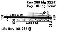
| Runways: | 10L/28R 10R/28L |
| Longest Runway: | 10L/28R is 3404 ft (1038 m) long |
| Runways with an Instrument Approach: |
38D Airport Runway Details
| Runway 10L/28R | 3404 ft x 50 ft (1038 m x 15 m) | |
| Runway Length Source: | FAA OE/AAA as of 07/24/2020 | |
| Surface: | Asphalt - Poor condition - No special surface treatment | |
| Runway Edge Lights: | Non-standard lighting system Intensity | |
Runway Weight Bearing Capacity (in thousands of pounds) |
||
| Single Wheel Landing Gear: | 8.0 | |
Runway 10L |
Runway 28R |
|
Elevation: |
1153.0 | 1162.0 |
Latitude: |
40-56-53.6600N | 40-56-53.6300N |
Longitude: |
080-52-07.9200W | 080-51-23.5500W |
|
Runway True Alignment: |
090 | 270 |
Glide Path Angle: |
0.0 degrees | 0.0 degrees |
Runway Markings Type: |
Nonstandard (other than numbers only) | Nonstandard (other than numbers only) |
Runway Markings Condition: |
Poor | Poor |
Object at End: |
TREES | HILL |
Object Height: |
40 | 45 |
Distance from End: |
460 | 950 |
Object Centerline Offset: |
200 ft. left and right of centerline | 200 ft. left and right of centerline |
Threshold Elevation: |
1160.0 | |
Displaced Threshold: |
266 | |
Threshold Latitude: |
40-56-53.6100N | |
Threshold Longitude: |
080-51-27.0100W |
| Runway 10R/28L | 2550 ft x 60 ft (777 m x 18 m) | |
| Runway Length Source: | FAA OE/AAA as of 07/24/2020 | |
| Surface: | Asphalt - Poor condition - No special surface treatment | |
Runway 10R |
Runway 28L |
|
Elevation: |
1153.0 | 1162.0 |
Latitude: |
40-56-52.3500N | 40-56-52.3500N |
Longitude: |
080-51-57.1200W | 080-51-23.8900W |
|
Runway True Alignment: |
090 | 270 |
Glide Path Angle: |
0.0 degrees | 0.0 degrees |
Runway Markings Type: |
None | None |
Object at End: |
TREES | POLE |
Object Height: |
85 | 35 |
Distance from End: |
0 | 89 |
Object Centerline Offset: |
200 ft. left and right of centerline | 200 ft. left and right of centerline |
Services
Airframe Repair: |
Major |
Powerplant Repair: |
Major |
Bottled Oxygen: |
None |
Bulk Oxygen: |
High Pressure / Low Pressure |
Fuel Available: |
100LL, Jet A, Jet A+ |
Parking: |
Hangars and tiedowns available |
Maps & Diagrams
38D Sectional
Flight Planning
at skyvector.com
at skyvector.com