Location
Latitude: |
42-10-41.8620N (42.178295) |
Longitude: |
095-47-37.1230W (-95.793645) |
Elevation: |
1116.0 feet MSL (340 m MSL) |
Magnetic Variation: |
2 E (as of April 2024 from WMM2020 model) |
Time Zone: |
UTC -6.0 (Standard Time) UTC -5.0 (Daylight Savings Time) |
From City: |
01 N.M. N of Mapleton, Iowa |
Found On: |
Omaha Chart |
FAA Region: |
ACE |
Contacts
Manager: |
Publicly owned: |
| KARLA UHL 513 MAIN STREET MAPLETON, IA 51034 712-881-1890 |
CITY OF MAPLETON 513 MAIN MAPLETON, IA 51034 712-881-1351 |
Operations
Airport Status: |
Operational |
Facility Use: |
Public |
Type: |
Airport |
Activation Date: |
08/1967 |
Control tower: |
No |
Attendance (Months/Days/Hours): |
Months/Days/Hours ALL/MON-FRI/0800-1700 |
Boundary ARTCC: |
ZMP (Minneapolis) |
Responsible ARTCC: |
ZMP (Minneapolis) |
Lighting Schedule: |
SEE RMK |
Segmented Circle Indicator: |
No |
Traffic Pattern Altitude (MSL): |
2116 feet (645 m) |
NOTAMs Facility: |
FOD |
NOTAM-D Service: |
Yes |
International Airport of Entry: |
No |
Customs Landing Rights: |
No |
Military Landing Rights: |
Yes |
Civil/Military Joint Use: |
No |
Based Aircraft
| Single Engine: | 10 |
Annual Operations (as of 08/10/2022)
| Total Operations: | 2500 | |
| GA Local: | 1080 | 43.2% |
| GA Itinerant: | 1420 | 56.8% |
Communications
| CTAF: | 122.800 |
| Unicom: | 122.800 |
| Approach: | SIOUX CITY 124.6 124.6 MINNEAPOLIS ARTCC |
| Departure: | SIOUX CITY 124.6 124.6 MINNEAPOLIS ARTCC |
- APCH/DEP SVC PRVDD BY MINNEAPOLIS ARTCC ON FREQS 119.6/290.4 (OMAHA RCAG) WHEN SIOUX CITY ATCT CLSD.
Fixed Based Operators (FBOs) & Fuel
(Click on a business for detail)
Please help us keep this information up to date. This is a FREE SERVICE just like everything else on Airport Guide! If you see that a business needs to be added, modified, or deleted please fill out our Update Form.
To add, modify, or delete a business click here.
Please help us keep this information up to date. This is a FREE SERVICE just like everything else on Airport Guide! If you see that a business needs to be added, modified, or deleted please fill out our Update Form.
Area Code: 712 |
| Business Name | Frequency | Phone | Fuel Grade |
|---|
Flight Service Stations
| Primary | Alternate | |
| FSS on Field: | N | |
| FSS Name (ID): | Fort Dodge(FOD) | |
| Frequency: | ||
| Toll Free Phone: | 1-800-WX-BRIEF |
Instrument Procedures / Charts
FAA Terminal Procedures valid from 0901Z 03/21/24 to 0901Z 04/18/24.
There are various types of charts available for an airport. They are listed in the Page Type column. Here is a legend for those types:
APD - Airport Diagram
DP - Departure Procedure Charts
HOT - Hot Spots
IAP - Instrument Approach Procedure Charts
MIN - Minimums
STAR - Standard Terminal Arrival Charts
| Page Type | Page Name | Volume | Action Since Last Cycle |
|---|---|---|---|
| IAP | RNAV (GPS) RWY 02 | NC-3 | |
| IAP | RNAV (GPS) RWY 20 | NC-3 | |
| MIN | TAKEOFF MINIMUMS | NC-3 |
Terminal Procedures are only available for airports in several countries with more being added all the time. If you are looking for a specific country's charts, please send an email to support(at)airportguide.com stating the country name. This will be used to prioritize the implementation.
Navigation Aids (Navaids) near KMEY
| Dist (NM) | ID | Morse Code | Name | Type | Freq | True Hdg | Mag Hdg |
|---|---|---|---|---|---|---|---|
| 0.1 | MEY | _ _ . _ . _ _ | Mapleton | NDB | 335 | 340 | 338 |
| 21.8 | DNS | _ . . _ . . . . | Denison | NDB | 350 | 122 | 120 |
| 23.8 | SU | . . . . . _ | Salix | NDB | 414 | 292 | 290 |
| 25.6 | SUX | . . . . . _ _ . . _ | Sioux City | TACAN | 116.50 | 293 | 291 |
| 29.7 | GAK | _ _ . . _ _ . _ | Sioux Gateway | NDB | 233 | 297 | 295 |
| 30.4 | TQE | _ _ _ . _ . | Tekamah | VOR | 108.40 | 214 | 212 |
| 34.1 | OI | _ _ _ . . | Tommi | NDB | 305 | 299 | 297 |
| 35.1 | SLB | . . . . _ . . _ . . . | Storm Lake | NDB | 434 | 43 | 41 |
| 38.0 | SKI | . . . _ . _ . . | Sac City | NDB | 356 | 71 | 69 |
| 41.3 | HNR | . . . . _ . . _ . | Harlan | NDB | 272 | 150 | 148 |
| 49.2 | ADU | . _ _ . . . . _ | Audubon | NDB | 266 | 126 | 124 |
| 49.2 | OM | _ _ _ _ _ | Gerfi | NDB | 320 | 188 | 186 |
| 50.1 | ORC | _ _ _ . _ . _ . _ . | Orange City | NDB | 521 | 346 | 344 |
| 50.7 | SCB | . . . _ . _ . _ . . . | Scribner | VOR-DME | 111.00 | 227 | 225 |
| 53.1 | OMA | _ _ _ _ _ . _ | Omaha | VOT | 109.00 | 184 | 182 |
| 57.2 | AIO | . _ . . _ _ _ | Atlantic | NDB | 365 | 144 | 142 |
| 57.5 | EN | . _ . | Rikky | NDB | 426 | 181 | 179 |
| 59.9 | SOY | . . . _ _ _ _ . _ _ | Sioux Center | NDB | 368 | 343 | 341 |
| 60.7 | OVR | _ _ _ . . . _ . _ . | Omaha | VORTAC | 116.30 | 177 | 175 |
| 60.7 | MLE | _ _ . _ . . . | Millard | NDB | 371 | 193 | 191 |
Nearby Airports with Fuel
Notices to Airmen (NOTAMS)
Remarks
| A110*G | THIS AIRPORT HAS BEEN SURVEYED BY THE NATIONAL GEODETIC SURVEY. |
| A110-1 | RY 20 IS CALM WIND RY. |
| A110-2 | FOR CD CTC SIOUX CITY ATCT ON 124.6 OR CALL 712-293-2482. |
| A110-3 | RWY 20 PAPI UNUSBL BYD 7 DEGS LEFT OF CNTRLN. |
| A81-APT | ACTVT REIL RWY 20; PAPI RWY 02 & 20; MIRL RWY 02/20 - CTAF. |
Runways
Runway Summary
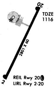
| Runways: | 02/20 |
| Longest Runway: | 02/20 is 2801 ft (854 m) long |
| Runways with an Instrument Approach: |
KMEY Airport Runway Details
| Runway 02/20 | 2801 ft x 60 ft (854 m x 18 m) | |
| Surface: | Concrete - Fair condition - No special surface treatment | |
| Runway Pavement Class: | 9 /R/C/W/U | |
| Runway Edge Lights: | Medium Intensity | |
Runway Weight Bearing Capacity (in thousands of pounds) |
||
| Single Wheel Landing Gear: | 28.0 | |
| Dual Wheel Landing Gear: | 48.0 | |
Runway 02 |
Runway 20 |
|
Elevation: |
1116.0 | 1116.0 |
Latitude: |
42-10-29.2800N | 42-10-54.5310N |
Longitude: |
095-47-44.7050W | 095-47-29.4980W |
|
Runway True Alignment: |
024 | 204 |
Glide Path Angle: |
3.8 degrees | 3.8 degrees |
Traffic Pattern: |
Left | Left |
Runway Markings Type: |
Nonprecision Instrument | Nonprecision Instrument |
Runway Markings Condition: |
Fair | Fair |
Object at End: |
TREE | |
Object Height: |
36 | |
Distance from End: |
1014 | |
Object Centerline Offset: |
77 ft. left of centerline | |
Visual Glide Slope Indicators: |
2-Light PAPI On Left Side Of Runway | 2-Light PAPI On Left Side Of Runway |
REIL: |
No | Yes |
Threshold Crossing Height: |
34 | 34 |
Services
Airframe Repair: |
Minor |
Powerplant Repair: |
Minor |
Bottled Oxygen: |
None |
Bulk Oxygen: |
None |
Fuel Available: |
100LL, Jet A |
Landing Fees: |
No |
Parking: |
Hangars and tiedowns available |
Maps & Diagrams
KMEY Sectional
Flight Planning
at skyvector.com
at skyvector.com