Location
Latitude: |
38-49-51.3000N (38.830917) |
Longitude: |
094-53-25.1000W (-94.890306) |
Elevation: |
1087.3 feet MSL (331 m MSL) |
Magnetic Variation: |
1.4 E (as of April 2024 from WMM2020 model) |
Time Zone: |
UTC -6.0 (Standard Time) UTC -5.0 (Daylight Savings Time) |
From City: |
04 N.M. SW of Olathe, Kansas |
Found On: |
Kansas City Chart |
FAA Region: |
ACE |
Contacts
Manager: |
Publicly owned: |
| BRYAN JOHNSON ONE NEW CENTURY PARKWAY NEW CENTURY, KS 66031 913-715-6002 |
JOHNSON CO ONE NEW CENTURY PARKWAY NEW CENTURY, KS 66031 913-715-6000 |
Operations
Airport Status: |
Operational |
Facility Use: |
Public |
Type: |
Airport |
Control tower: |
Yes |
Attendance (Months/Days/Hours): |
Months/Days/Hours ALL/SUN-THU/ALL |
Boundary ARTCC: |
ZKC (Kansas City) |
Responsible ARTCC: |
ZKC (Kansas City) |
Lighting Schedule: |
SEE RMK |
Segmented Circle Indicator: |
Yes |
Traffic Pattern Altitude (MSL): |
2087 feet (636 m) |
NOTAMs Facility: |
IXD |
NOTAM-D Service: |
Yes |
International Airport of Entry: |
No |
Customs Landing Rights: |
No |
Military Landing Rights: |
Yes |
Civil/Military Joint Use: |
No |
Based Aircraft
| Single Engine: | 103 |
| Multi Engine: | 25 |
| Jet Engine: | 38 |
| GA Helicopters: | 1 |
| Military Aircraft: | 16 |
Annual Operations (as of 07/31/2019)
| Total Operations: | 53678 | |
| Commercial: | 1 | 0.0% |
| Air Taxi: | 2760 | 5.1% |
| GA Local: | 24680 | 46.0% |
| GA Itinerant: | 24313 | 45.3% |
| Military Aircraft: | 1924 | 3.6% |
Communications
| CTAF: | 133.000 |
| Unicom: | 122.950 |
| Tower: | NEW CENTURY 133.0 Hrs: 0600-2200 |
| Ground: | 124.3 |
| Approach: | KANSAS CITY |
| Departure: | KANSAS CITY |
| ASOS: | 135.325 (913-780-6987) |
| ARMY OPS: | 347.5 |
| ARMY OPS: | 46.9FM |
Fixed Based Operators (FBOs) & Fuel
(Click on a business for detail)
Please help us keep this information up to date. This is a FREE SERVICE just like everything else on Airport Guide! If you see that a business needs to be added, modified, or deleted please fill out our Update Form.
To add, modify, or delete a business click here.
Please help us keep this information up to date. This is a FREE SERVICE just like everything else on Airport Guide! If you see that a business needs to be added, modified, or deleted please fill out our Update Form.
Area Code: 913 |
| Business Name | Frequency | Phone | Fuel Grade |
|---|---|---|---|
| Executive Beechcraft, Inc.
Update FBO info |
Unicom 122.95 | 782-9003 | 100LL, Jet A |
| Johnson County Industrial Avionics
Update FBO info |
764-2126 | ||
| Kings Aviation
Update FBO info |
Unicom 122.95 | 829-4606, -0665 | 100LL, Jet A |
| New Century Air Service
Website Update FBO info |
122.95 | 913-768-9400 | |
| Signature Flight Support
Update FBO info |
Unicom: 122.95, Arinc: 129 | +1 913 782 9003 |
Flight Service Stations
| Primary | Alternate | |
| FSS on Field: | N | |
| FSS Name (ID): | Columbia(COU) | |
| Frequency: | ||
| Toll Free Phone: | 1-800-WX-BRIEF |
Instrument Procedures / Charts
FAA Terminal Procedures valid from 0901Z 03/21/24 to 0901Z 04/18/24.
There are various types of charts available for an airport. They are listed in the Page Type column. Here is a legend for those types:
APD - Airport Diagram
DP - Departure Procedure Charts
HOT - Hot Spots
IAP - Instrument Approach Procedure Charts
MIN - Minimums
STAR - Standard Terminal Arrival Charts
| Page Type | Page Name | Volume | Action Since Last Cycle |
|---|---|---|---|
| APD | AIRPORT DIAGRAM | NC-2 | |
| DP | CHIEF NINE | NC-2 | |
| DP | LAKES FIVE | NC-2 | |
| DP | RACER EIGHT | NC-2 | |
| DP | ROYAL ONE | NC-2 | |
| DP | TIFTO EIGHT | NC-2 | |
| DP | WILDCAT SIX | NC-2 | |
| HOT | HOT SPOT | NC-2 | |
| IAP | ILS OR LOC RWY 36 | NC-2 | |
| IAP | RNAV (GPS) RWY 04 | NC-2 | |
| IAP | RNAV (GPS) RWY 18 | NC-2 | |
| IAP | RNAV (GPS) RWY 22 | NC-2 | |
| IAP | RNAV (GPS) RWY 36 | NC-2 | |
| MIN | ALTERNATE MINIMUMS | NC-2 | |
| MIN | TAKEOFF MINIMUMS | NC-2 | |
| STAR | BRAYMER EIGHT | NC-2 | |
| STAR | BRAYMER EIGHT[DELIMITER] CONT.1 | NC-2 | |
| STAR | JHAWK SEVEN | NC-2 | |
| STAR | TYGER SEVEN | NC-2 | |
| STAR | TYGER SEVEN[DELIMITER] CONT.1 | NC-2 |
Terminal Procedures are only available for airports in several countries with more being added all the time. If you are looking for a specific country's charts, please send an email to support(at)airportguide.com stating the country name. This will be used to prioritize the implementation.
Navigation Aids (Navaids) near JCI
| Dist (NM) | ID | Morse Code | Name | Type | Freq | True Hdg | Mag Hdg |
|---|---|---|---|---|---|---|---|
| 7.2 | OJC | _ _ _ . _ _ _ _ . _ . | Johnson County | VOR-DME | 113.00 | 85 | 84 |
| 8.6 | PK | . _ _ . _ . _ | Herbb | NDB | 420 | 122 | 121 |
| 13.3 | JZ | . _ _ _ _ _ . . | Newbn | NDB | 338 | 292 | 291 |
| 17.6 | GQ | _ _ . _ _ . _ | Norge | NDB | 517 | 38 | 37 |
| 22.1 | RIS | . _ . . . . . . | Riverside | VOR-DME | 111.40 | 38 | 37 |
| 22.2 | MKC | _ _ _ . _ _ . _ . | Kansas City Downtown | VOT | 108.60 | 37 | 36 |
| 24.3 | DO | _ . . _ _ _ | Dotte | NDB | 359 | 15 | 14 |
| 28.2 | MCI | _ _ _ . _ . . . | Kansas City | VORTAC | 113.25 | 14 | 13 |
| 32.5 | FO | . . _ . _ _ _ | Riply | NDB | 326 | 275 | 273 |
| 35.8 | TOP | _ _ _ _ . _ _ . | Topeka | VORTAC | 117.80 | 301 | 299 |
| 36.7 | FOE | . . _ . _ _ _ . | Forbes | TACAN | 111.60 | 281 | 279 |
| 37.0 | FOE | . . _ . _ _ _ . | Forbes | VOT | 111.00 | 281 | 279 |
| 38.5 | BUM | _ . . . . . _ _ _ | Butler | VORTAC | 115.90 | 150 | 149 |
| 38.9 | ANX | . _ _ . _ . . _ | Napoleon | VORTAC | 114.00 | 65 | 64 |
| 41.0 | TO | _ _ _ _ | Biloy | NDB | 521 | 295 | 293 |
| 50.4 | UKL | . . _ _ . _ . _ . . | Boyd | NDB | 245 | 231 | 229 |
| 50.7 | ST | . . . _ | Tario | NDB | 260 | 359 | 358 |
| 62.3 | FSK | . . _ . . . . _ . _ | Fort Scott | NDB | 379 | 174 | 173 |
| 62.9 | SZL | . . . _ _ . . . _ . . | Whiteman | TACAN | 109.80 | 94 | 93 |
| 63.2 | AZN | . _ _ _ . . _ . | Amazon | NDB | 233 | 359 | 358 |
Nearby Airports with Fuel
Notices to Airmen (NOTAMS)
Remarks
| A110-3 | BIRDS & WATERFOWL ON & INVOF ARPT. |
| A110-4 | ATCT VIEW OF SW END OF TWY 'F' & RY 04/22 IS OBSCURED. |
| A110-5 | LOW SUN ANGLES REDUCE VISIBILITY WHEN CROSSING RY 18/36 FM TWYS 'A' OR 'B'. |
| A110-6 | ARMY OPS: DSN 552-6994/5, C913-782-1077. |
| A110-7 | TO CONFIRM SNOW REMOVAL AND WINTER CONDITIONS NOV-APR CALL 913-715-6005. |
| A110-8 | FOR CD WHEN ATCT IS CLSD CTC MCI APCH AT 118.90. |
| A81-APT | WHEN TWR CLSD ACTVT HIRL RY 18-36, MIRL RY 4-22, MALSR RY 36, REIL RY 18, TWY LGTS, AND WIND CONE - CTAF. VASI RY 18, PAPI RY 4-22 OPR CONTINUOUSLY. |
| E111 | AVOID CONFLICT GARDNER MUNI:EXT UNIQUE PATTERN ALT, RT TFC RWYS 04/36, & RESTRICT RWY 04/22 CAT A ACFT. |
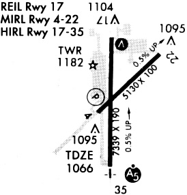
Runways
Runway Summary
| Runways: | 04/22 18/36 |
| Longest Runway: | 18/36 is 7339 ft (2237 m) long |
| Runways with an Instrument Approach: | 36 |
JCI Airport Runway Details
| Runway 04/22 | 5132 ft x 100 ft (1564 m x 30 m) | |
| Runway Length Source: | 3RD PARTY SURVEY as of 10/29/2009 | |
| Surface: | Asphalt - Fair condition - No special surface treatment | |
| Runway Pavement Class: | 16 /F/C/Y/U | |
| Runway Edge Lights: | Medium Intensity | |
Runway Weight Bearing Capacity (in thousands of pounds) |
||
| Single Wheel Landing Gear: | 47.0 | |
| Dual Wheel Landing Gear: | 55.0 | |
Runway 04 |
Runway 22 |
|
Elevation: |
1061.1 | 1087.2 |
Latitude: |
38-49-41.5474N | 38-50-16.1189N |
Longitude: |
094-53-42.2282W | 094-52-54.7781W |
|
Runway True Alignment: |
047 | 227 |
Glide Path Angle: |
3.0 degrees | 3.0 degrees |
Traffic Pattern: |
Right | Left |
Runway Markings Type: |
Nonprecision Instrument | Nonprecision Instrument |
Runway Markings Condition: |
Good | Good |
Visual Glide Slope Indicators: |
4-Light PAPI On Left Side Of Runway | 4-Light PAPI On Left Side Of Runway |
Threshold Crossing Height: |
41 | 45 |
| Runway 18/36 | 7339 ft x 150 ft (2237 m x 46 m) | |
| Runway Length Source: | 3RD PARTY SURVEY as of 10/29/2009 | |
| Surface: | Asphalt - Fair condition - No special surface treatment | |
| Runway Pavement Class: | 28 /F/C/X/U | |
| Runway Edge Lights: | High Intensity | |
Runway Weight Bearing Capacity (in thousands of pounds) |
||
| Single Wheel Landing Gear: | 75.0 | |
| Dual Wheel Landing Gear: | 175.0 | |
| Dual Tandem Wheel Landing Gear: | 350.0 | |
Runway 18 |
Runway 36 |
|
Elevation: |
1084.9 | 1051.5 |
Latitude: |
38-50-22.2392N | 38-49-09.7064N |
Longitude: |
094-53-29.6606W | 094-53-29.7175W |
|
Runway True Alignment: |
180 | 000 |
ILS Type: |
ILS/DME | |
Glide Path Angle: |
3.0 degrees | 0.0 degrees |
Traffic Pattern: |
Left | Right |
Runway Markings Type: |
Precision Instrument | Precision Instrument |
Runway Markings Condition: |
Good | Good |
Visual Glide Slope Indicators: |
2-Box VASI On Left Side Of Runway | |
Approach Light System: |
1,400 Foot Medium Intensity Approach Lighting System With Runway Alignment Indicator Lights | |
REIL: |
Yes | |
Threshold Crossing Height: |
46 |
Services
Bottled Oxygen: |
None |
Bulk Oxygen: |
None |
Fuel Available: |
100LL |
Landing Fees: |
No |
Parking: |
Tiedowns available |
Maps & Diagrams
JCI Sectional
Flight Planning
at skyvector.com
at skyvector.com