Location
Latitude: |
38-57-03.4170N (38.950949) |
Longitude: |
095-39-49.0090W (-95.663614) |
Elevation: |
1077.9 feet MSL (329 m MSL) |
Magnetic Variation: |
1.9 E (as of April 2024 from WMM2020 model) |
Time Zone: |
UTC -6.0 (Standard Time) UTC -5.0 (Daylight Savings Time) |
From City: |
06 N.M. S of Topeka, Kansas |
Found On: |
Kansas City Chart |
FAA Region: |
ACE |
Contacts
Manager: |
Publicly owned: |
| MR ERIC M JOHNSON 6510 SE FORBES AVE #1 TOPEKA, KS 66619 785-862-2362 |
METROPOLITAN TOPEKA ARPT AUTH 6510 SE FORBES AVE #1 TOPEKA, KS 66619 785-862-2362 |
Operations
Airport Status: |
Operational |
Facility Use: |
Public |
Type: |
Airport |
Activation Date: |
02/1944 |
Control tower: |
Yes |
Attendance (Months/Days/Hours): |
Months/Days/Hours ALL/ALL/0545-2200 |
Boundary ARTCC: |
ZKC (Kansas City) |
Responsible ARTCC: |
ZKC (Kansas City) |
Lighting Schedule: |
SEE RMK |
Segmented Circle Indicator: |
No |
Traffic Pattern Altitude (MSL): |
2078 feet (633 m) |
NOTAMs Facility: |
FOE |
NOTAM-D Service: |
Yes |
International Airport of Entry: |
No |
Customs Landing Rights: |
No |
Military Landing Rights: |
Yes |
Civil/Military Joint Use: |
No |
Aircraft Rescue and Firefighting: |
Class IV ARFF Index: A Air Carrier Service: Not Scheduled Certification Date: 04/1976 |
Based Aircraft
| Single Engine: | 10 |
| Multi Engine: | 3 |
| Jet Engine: | 10 |
| Military Aircraft: | 18 |
Annual Operations (as of 10/31/2021)
| Total Operations: | 30086 | |
| Commercial: | 102 | 0.3% |
| Air Taxi: | 427 | 1.4% |
| GA Local: | 2873 | 9.5% |
| GA Itinerant: | 8504 | 28.3% |
| Military Aircraft: | 18180 | 60.4% |
Communications
| CTAF: | 120.800 |
| Unicom: | 122.950 |
| Tower: | FORBES 120.8 340.2 236.6 Hrs: 0545-2200 |
| Ground: | 118.425 275.8 |
| Approach: | KANSAS CITY ARTCC |
| Departure: | KANSAS CITY ARTCC |
| ATIS: | 128.25 Hrs: 24 |
| ASOS: | (785-862-8258) |
| ARNG OPS: | 32.1 |
| EMERG: | 121.5 |
| RANGE CTL: | 229.5 |
| EMERG: | 243.0 |
| ANG OPS: | 255.5 |
- APCH/DEP CTL SVC PRVDD BY KANSAS CITY ARTCC (ZKC) ON FREQS 123.8/343.7 (TOPEKA RCAG).
Fixed Based Operators (FBOs) & Fuel
(Click on a business for detail)
Please help us keep this information up to date. This is a FREE SERVICE just like everything else on Airport Guide! If you see that a business needs to be added, modified, or deleted please fill out our Update Form.
To add, modify, or delete a business click here.
Please help us keep this information up to date. This is a FREE SERVICE just like everything else on Airport Guide! If you see that a business needs to be added, modified, or deleted please fill out our Update Form.
Area Code: 785 |
| Business Name | Frequency | Phone | Fuel Grade |
|---|---|---|---|
| Mid-American Aviation
Update FBO info |
Unicom 122.95 | 862-2790 | 100LL, Jet A |
| Million Air Topeka
Update FBO info |
Unicom 122.95 | 862-0950, 888-545-8430 | 100LL, Jet A |
Flight Service Stations
| Primary | Alternate | |
| FSS on Field: | N | |
| FSS Name (ID): | Wichita(ICT) | |
| Frequency: | ||
| Toll Free Phone: | 1-800-WX-BRIEF |
Instrument Procedures / Charts
FAA Terminal Procedures valid from 0901Z 03/21/24 to 0901Z 04/18/24.
There are various types of charts available for an airport. They are listed in the Page Type column. Here is a legend for those types:
APD - Airport Diagram
DP - Departure Procedure Charts
HOT - Hot Spots
IAP - Instrument Approach Procedure Charts
MIN - Minimums
STAR - Standard Terminal Arrival Charts
| Page Type | Page Name | Volume | Action Since Last Cycle |
|---|---|---|---|
| APD | AIRPORT DIAGRAM | NC-2 | |
| HOT | HOT SPOT | NC-2 | |
| IAP | HI-TACAN RWY 13 | NC-2 | Changed |
| IAP | HI-TACAN RWY 31 | NC-2 | Changed |
| IAP | ILS OR LOC RWY 31 | NC-2 | |
| IAP | RNAV (GPS) RWY 03 | NC-2 | |
| IAP | RNAV (GPS) RWY 13 | NC-2 | |
| IAP | RNAV (GPS) RWY 21 | NC-2 | |
| IAP | RNAV (GPS) RWY 31 | NC-2 | |
| IAP | TACAN RWY 13 | NC-2 | |
| IAP | TACAN RWY 31 | NC-2 | |
| IAP | VOR/DME OR TACAN RWY 03 | NC-2 | |
| IAP | VOR/DME OR TACAN RWY 21 | NC-2 | |
| MIN | ALTERNATE MINIMUMS | NC-2 | |
| MIN | TAKEOFF MINIMUMS | NC-2 |
Terminal Procedures are only available for airports in several countries with more being added all the time. If you are looking for a specific country's charts, please send an email to support(at)airportguide.com stating the country name. This will be used to prioritize the implementation.
Navigation Aids (Navaids) near FOE
| Dist (NM) | ID | Morse Code | Name | Type | Freq | True Hdg | Mag Hdg |
|---|---|---|---|---|---|---|---|
| 0.2 | FOE | . . _ . _ _ _ . | Forbes | VOT | 111.00 | 286 | 284 |
| 0.2 | FOE | . . _ . _ _ _ . | Forbes | TACAN | 111.60 | 152 | 150 |
| 5.5 | FO | . . _ . _ _ _ | Riply | NDB | 326 | 135 | 133 |
| 10.2 | TO | _ _ _ _ | Biloy | NDB | 521 | 353 | 351 |
| 12.4 | TOP | _ _ _ _ . _ _ . | Topeka | VORTAC | 117.80 | 25 | 23 |
| 23.9 | JZ | . _ _ _ _ _ . . | Newbn | NDB | 338 | 95 | 93 |
| 39.2 | UKL | . . _ _ . _ . _ . . | Boyd | NDB | 245 | 183 | 181 |
| 43.8 | OJC | _ _ _ . _ _ _ _ . _ . | Johnson County | VOR-DME | 113.00 | 98 | 96 |
| 44.9 | PK | . _ _ . _ . _ | Herbb | NDB | 420 | 105 | 103 |
| 45.4 | EMP | . _ _ . _ _ . | Emporia | VORTAC | 112.80 | 209 | 207 |
| 45.5 | DO | _ . . _ _ _ | Dotte | NDB | 359 | 68 | 66 |
| 47.5 | GQ | _ _ . _ _ . _ | Norge | NDB | 517 | 81 | 79 |
| 47.6 | MCI | _ _ _ . _ . . . | Kansas City | VORTAC | 113.25 | 64 | 62 |
| 48.3 | MHK | _ _ . . . . _ . _ | Manhattan | VOR-DME | 110.20 | 284 | 282 |
| 50.7 | MKC | _ _ _ . _ _ . _ . | Kansas City Downtown | VOT | 108.60 | 77 | 75 |
| 50.8 | RIS | . _ . . . . . . | Riverside | VOR-DME | 111.40 | 78 | 76 |
| 52.9 | CVY | _ . _ . . . . _ _ . _ _ | Cavalry | NDB | 314 | 275 | 273 |
| 55.1 | RBA | . _ . _ . . . . _ | Robinson | DME | 108.2 | 11 | 9 |
| 55.8 | HRU | . . . . . _ . . . _ | Herington | NDB | 407 | 254 | 252 |
| 55.9 | FRI | . . _ . . _ . . . | Fort Riley | VOR | 109.40 | 271 | 269 |
Nearby Airports with Fuel
Notices to Airmen (NOTAMS)
Remarks
| A110-10 | JASU: 14(A/M32A-86D) 11(A/M32A-95) |
| A110-11 | FUEL: A+ (MILLION AIRTOPEKA,1200-0400Z++, C785-862-0950; OT 3 HR PN RQR, C785-862-6104/785-224-2899.) A++(MIL) |
| A110-12 | FLUID: ADI SP LPOX LOX OIL - O-128-148(MIL) - AVBL ONLY IN QT CANS. |
| A110-13 | CAUTION: DO NOT MISTAKE PHILIP BILLARD MUNI, LCTD 7 NM N HDG 010 DEG, FOR TOPEKA RGNL. |
| A110-14 | NSABTMT: VFR TFC AVOID OVFT OF HSG AREA 2 NM W RWY 13. |
| A110-15 | MISC: RWY 13-31 GROOVED. |
| A110-17 | ANG: PPR FOR ANG RAMP AND SVC DSN 720-4655/4663, NO LATER THAN 72 HR. PRIOR. AIRFIELD MGMT, MAINT OPR CTL (MOC), AND POL AVBL 1330-2200Z++ WKD, CLSD WKEND AND FEDERAL HOL. SVC MAY BE AVBL OT, ACFT PRK ON ANG RAMP, CTC WYLIE CON 20 MIN PRIOR LDG, ADVS ON ARR AND DEP 255.5. |
| A110-19 | ANG CONT: NO FLEET SVC AVBL. OIL (SOAP) SAMPLING NOT AVBL. NO DRAG CHUTE REPACK AVBL. PRECISION MEASURING EQPT LABORATORY PICKUP AND DEL EXP 1.5 HR DELAY. TRAN SVC AVBL AT FBO. TRAN MAINT AND PARTS SUPPORT (EXC KC-135R ACFT)EXTREMELY LTD. NO QTRS AVBL. DE-ICING FLUID AVBL TO TRAN ACFT AT FBO. |
| A110-2 | TFC PTN: 1000 FT AGL FOR LGT (SLOW) ACFT & 1500 FT FOR HEAVY (FAST) ACFT. |
| A110-20 | ARNG: OPR 1300-2300Z++TUE-FRI EXC HOL, OCNL SAT, SUN. LTD MAINT UH-60A. TRANS ARMY ACFT CTC OPS DSN 720-8725, C785-274-1725. OPS CALL COML 785-646-3825/3827. ARMY ACFT CTC RNG OPS 32.1. ARNG RAMP & FAC LCTD WEST OF APCH END RWY 03. |
| A110-21 | CAUTION: BIRD HAZ PHASE II APR-MAY & AUG-OCT. |
| A110-6 | (E110) OPERS ARPT LGTG ONLY. |
| A110-8 | LARGE & SMALL MIGRATORY BIRDS ON & INVOF ARPT. |
| A17 | MILITARY USE: SEE FLIP AP/1 SUPPLEMENTARY ARPT RMK. |
| A26 | PPR 24 HRS FOR UNSCHEDULED AIR CARRIER OPERATIONS WITH MORE THAN 30 PASSENGER SEATS, CALL ARPT MGR 785-862-2362. ARFF INDEX B PROVIDED. ARFF INDEX C LEVEL EQUIP AVBL UPON REQUEST. |
| A48-13 | REIL RWY 13 OTS. |
| A81-APT | WHEN ATCT CLSD, ACTVT MALSF RWY 13; MALSR RWY 31; MIRL RWY 03/21; & HIRL RWY 13/31 - CTAF. VASI RWY 03 AND PAPI RWY 13, 21 & 31 OPR CONSLY. |
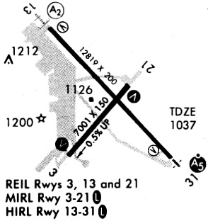
Runways
Runway Summary
| Runways: | 03/21 13/31 |
| Longest Runway: | 13/31 is 12803 ft (3902 m) long |
| Runways with an Instrument Approach: | 31 |
FOE Airport Runway Details
| Runway 03/21 | 7002 ft x 150 ft (2134 m x 46 m) | |
| Runway Length Source: | 3RD PARTY SURVEY as of 04/22/2016 | |
| Surface: | Asphalt - Excellent condition - Saw-cut or plastic grooved | |
| Runway Pavement Class: | 46 /R/C/X/T | |
| Runway Edge Lights: | Medium Intensity | |
Runway Weight Bearing Capacity (in thousands of pounds) |
||
| Single Wheel Landing Gear: | 75.0 | |
| Dual Wheel Landing Gear: | 140.0 | |
| Dual Tandem Wheel Landing Gear: | 220.0 | |
| Dual Dual Tandem Wheel Landing Gear: | 620.0 | |
Runway 03 |
Runway 21 |
|
Elevation: |
1077.9 | 1043.2 |
Latitude: |
38-56-25.3444N | 38-57-18.4946N |
Longitude: |
095-40-23.3262W | 095-39-26.5769W |
|
Runway True Alignment: |
040 | 220 |
Glide Path Angle: |
3.0 degrees | 3.0 degrees |
Traffic Pattern: |
Right | Left |
Runway Markings Type: |
Nonprecision Instrument | Nonprecision Instrument |
Runway Markings Condition: |
Good | Good |
Object at End: |
TREE | |
Object Height: |
36 | |
Distance from End: |
1850 | |
Object Centerline Offset: |
200 ft. right of centerline | |
Visual Glide Slope Indicators: |
4-Box VASI On Left Side Of Runway | 4-Light PAPI On Left Side Of Runway |
REIL: |
Yes | Yes |
Threshold Crossing Height: |
47 | 52 |
Declared Distances |
||
Take Off Run Avbl. (TORA): |
7001 | 7001 |
Take Off Distance Avbl. (TODA): |
7001 | 7001 |
Actual Stop Dist. Avbl. (ASDA): |
7001 | 7001 |
Landing Dist. Avbl. (LDA): |
7001 | 7001 |
| Runway 13/31 | 12803 ft x 150 ft (3902 m x 46 m) | |
| Runway Length Source: | 3RD PARTY SURVEY as of 04/22/2016 | |
| Surface: | Asphalt - Excellent condition - Saw-cut or plastic grooved | |
| Runway Pavement Class: | 89 /R/C/X/T | |
| Runway Edge Lights: | High Intensity | |
Runway Weight Bearing Capacity (in thousands of pounds) |
||
| Single Wheel Landing Gear: | 75.0 | |
| Dual Wheel Landing Gear: | 200.0 | |
| Dual Tandem Wheel Landing Gear: | 280.0 | |
| Dual Dual Tandem Wheel Landing Gear: | 760.0 | |
Runway 13 |
Runway 31 |
|
Elevation: |
1063.1 | 1035.9 |
Latitude: |
38-57-56.0100N | 38-56-23.3913N |
Longitude: |
095-40-40.9797W | 095-38-50.5563W |
|
Runway True Alignment: |
137 | 317 |
ILS Type: |
ILS/DME | |
Glide Path Angle: |
3.0 degrees | 3.0 degrees |
Traffic Pattern: |
Right | Left |
Runway Markings Type: |
Precision Instrument | Precision Instrument |
Runway Markings Condition: |
Fair | Fair |
Object at End: |
TREE | TREE |
Object Height: |
35 | 59 |
Distance from End: |
1750 | 2900 |
Object Centerline Offset: |
200 ft. right of centerline | |
Visual Glide Slope Indicators: |
4-Light PAPI On Left Side Of Runway | 4-Light PAPI On Left Side Of Runway |
Runway Visual Range (RVR): |
Rollout | Touchdown |
Approach Light System: |
1,400 Foot Medium Intensity Approach Lighting System With Sequenced Flashers | 1,400 Foot Medium Intensity Approach Lighting System With Runway Alignment Indicator Lights |
REIL: |
Yes | |
Threshold Crossing Height: |
54 | 59 |
Declared Distances |
||
Take Off Run Avbl. (TORA): |
12803 | 12803 |
Take Off Distance Avbl. (TODA): |
12803 | 12803 |
Actual Stop Dist. Avbl. (ASDA): |
12803 | 12803 |
Landing Dist. Avbl. (LDA): |
12803 | 12803 |
Services
Airframe Repair: |
Major |
Powerplant Repair: |
Major |
Bottled Oxygen: |
None |
Bulk Oxygen: |
None |
Fuel Available: |
100LL |
Landing Fees: |
No |
Parking: |
Tiedowns available |
Maps & Diagrams
FOE Sectional
Flight Planning
at skyvector.com
at skyvector.com