Location
Latitude: |
39-00-52.7083N (39.014641) |
Longitude: |
094-12-53.4904W (-94.214858) |
Elevation: |
835.0 feet MSL (255 m MSL) |
Magnetic Variation: |
0.9 E (as of April 2024 from WMM2020 model) |
Time Zone: |
UTC -6.0 (Standard Time) UTC -5.0 (Daylight Savings Time) |
From City: |
00 N.M. of Grain Valley, Missouri |
Found On: |
Kansas City Chart |
FAA Region: |
ACE |
Contacts
Manager: |
Privately owned: |
| DAN WILLIAMS BOX 255, 600 EE KIRBY RD GRAIN VALLEY, MO 64029 816-286-9206 |
GRAIN VALLEY AIRPORT CORP BOX 255 GRAIN VALLEY, MO 64029 816-229-8868 |
Operations
Airport Status: |
Operational |
Facility Use: |
Public |
Type: |
Airport |
Activation Date: |
09/1956 |
Control tower: |
No |
Attendance (Months/Days/Hours): |
Months/Days/Hours ALL/ALL/0800-DUSK |
Boundary ARTCC: |
ZKC (Kansas City) |
Responsible ARTCC: |
ZKC (Kansas City) |
Lighting Schedule: |
SEE RMK |
Segmented Circle Indicator: |
No |
Traffic Pattern Altitude (MSL): |
1835 feet (559 m) |
NOTAMs Facility: |
COU |
NOTAM-D Service: |
Yes |
International Airport of Entry: |
No |
Customs Landing Rights: |
No |
Military Landing Rights: |
Yes |
Civil/Military Joint Use: |
No |
Based Aircraft
| Single Engine: | 185 |
| Multi Engine: | 15 |
| GA Helicopters: | 1 |
Annual Operations (as of 12/31/2021)
| Total Operations: | 39980 | |
| Air Taxi: | 3200 | 8.0% |
| GA Local: | 31540 | 78.9% |
| GA Itinerant: | 5120 | 12.8% |
| Military Aircraft: | 120 | 0.3% |
Communications
| CTAF: | 122.800 |
| Unicom: | 122.800 |
| Approach: | KANSAS CITY 118.4 118.4 118.4 |
| Departure: | KANSAS CITY 118.4 118.4 118.4 |
Fixed Based Operators (FBOs) & Fuel
(Click on a business for detail)
Please help us keep this information up to date. This is a FREE SERVICE just like everything else on Airport Guide! If you see that a business needs to be added, modified, or deleted please fill out our Update Form.
To add, modify, or delete a business click here.
Please help us keep this information up to date. This is a FREE SERVICE just like everything else on Airport Guide! If you see that a business needs to be added, modified, or deleted please fill out our Update Form.
Area Code: 816 |
| Business Name | Frequency | Phone | Fuel Grade |
|---|---|---|---|
| Grain Valley Airport Corp.
Update FBO info |
Unicom 122.8 | 229-8868 | 100LL, Jet A, MOGAS |
Flight Service Stations
| Primary | Alternate | |
| FSS on Field: | N | |
| FSS Name (ID): | Columbia(COU) | |
| Frequency: | ||
| Toll Free Phone: | 1-800-WX-BRIEF |
Instrument Procedures / Charts
FAA Terminal Procedures valid from 0901Z 03/21/24 to 0901Z 04/18/24.
There are various types of charts available for an airport. They are listed in the Page Type column. Here is a legend for those types:
APD - Airport Diagram
DP - Departure Procedure Charts
HOT - Hot Spots
IAP - Instrument Approach Procedure Charts
MIN - Minimums
STAR - Standard Terminal Arrival Charts
| Page Type | Page Name | Volume | Action Since Last Cycle |
|---|---|---|---|
| IAP | RNAV (GPS) RWY 09 | NC-3 | |
| IAP | RNAV (GPS) RWY 27 | NC-3 | |
| MIN | TAKEOFF MINIMUMS | NC-3 |
Terminal Procedures are only available for airports in several countries with more being added all the time. If you are looking for a specific country's charts, please send an email to support(at)airportguide.com stating the country name. This will be used to prioritize the implementation.
Navigation Aids (Navaids) near 3GV
| Dist (NM) | ID | Morse Code | Name | Type | Freq | True Hdg | Mag Hdg |
|---|---|---|---|---|---|---|---|
| 6.3 | ANX | . _ _ . _ . . _ | Napoleon | VORTAC | 114.00 | 39 | 38 |
| 18.9 | RIS | . _ . . . . . . | Riverside | VOR-DME | 111.40 | 289 | 288 |
| 19.0 | MKC | _ _ _ . _ _ . _ . | Kansas City Downtown | VOT | 108.60 | 290 | 289 |
| 20.7 | GQ | _ _ . _ _ . _ | Norge | NDB | 517 | 277 | 276 |
| 26.5 | OJC | _ _ _ . _ _ _ _ . _ . | Johnson County | VOR-DME | 113.00 | 246 | 245 |
| 27.8 | DO | _ . . _ _ _ | Dotte | NDB | 359 | 296 | 295 |
| 29.0 | PK | . _ _ . _ . _ | Herbb | NDB | 420 | 237 | 236 |
| 29.2 | MCI | _ _ _ . _ . . . | Kansas City | VORTAC | 113.25 | 303 | 302 |
| 35.3 | SZL | . . . _ _ . . . _ . . | Whiteman | TACAN | 109.80 | 118 | 117 |
| 40.2 | BQS | _ . . . _ _ . _ . . . | Braymer | VOR-DME | 115.35 | 22 | 21 |
| 44.2 | JZ | . _ _ _ _ _ . . | Newbn | NDB | 338 | 262 | 261 |
| 46.4 | BUM | _ . . . . . _ _ _ | Butler | VORTAC | 115.90 | 196 | 195 |
| 46.5 | GLY | _ _ . . _ . . _ . _ _ | Golden Valley | NDB | 388 | 147 | 146 |
| 47.5 | PUR | . _ _ . . . _ . _ . | Marshall | NDB | 371 | 87 | 86 |
| 51.0 | ST | . . . _ | Tario | NDB | 260 | 321 | 320 |
| 52.0 | DMO | _ . . _ _ _ _ _ | Sedalia | NDB | 281 | 110 | 109 |
| 56.7 | CHT | _ . _ . . . . . _ | Chillicothe | NDB | 375 | 35 | 34 |
| 61.2 | AZN | . _ _ _ . . _ . | Amazon | NDB | 233 | 328 | 327 |
| 62.6 | TOP | _ _ _ _ . _ _ . | Topeka | VORTAC | 117.80 | 277 | 276 |
| 64.2 | FO | . . _ . _ _ _ | Riply | NDB | 326 | 263 | 262 |
Nearby Airports with Fuel
Notices to Airmen (NOTAMS)
Remarks
| A110-2 | WATERFOWL ON & INVOF ARPT. |
| A110-5 | NTSD RWY SAFETY AREA ALL RWY ENDS; INSUFFICIENT LENS & INCOR TRRN GRADES; NO RWY SAFETY AREA BYD RWY 05 & 27. |
| A110-6 | FOR CD CTC KANSAS CITY APCH AT 816-329-2710. |
| A31-05/23 | RWY 05/23 STEEP GRADE 60-235 FT NE OF RWY 05 THLD. |
| A32-05/23 | WIDTH VARIANCE 20-25 FT. |
| A32-09/27 | WIDTH VARIANCE 44-45 FT. |
| A40-09/27 | NSTD MIRL; NO YELLOW EDGE LGTS LAST 2000 FT BOTH ENDS; ALL EDGE LGTS LCTD 13-15 FT FM PAVEMENT EDGE; RWY 27 ONLY 6 THR LGTS LCTD 18-20 FT E OF THR. |
| A57-09 | 0:1 TO DSPLCD THLD; +1-5 FT GND 0-90 FT FM RWY END 70-130 FT RIGHT. |
| A58-05 | RR TRACK 0-200 FT FROM RWY, 80-230 FT RIGHT; TREES 20-35 FT, 0-200 FT FROM RWY, 130-250 FT RIGHT. |
| A58-09 | RWY 09 1-20 FT GND 0-200 FT FM RWY END LEFT & RIGHT; +16 FT SIGNS 145 FT FM RWY END 80 FT LEFT; 10-25 FT ROAD 0-200 FT FM RWY END 125-160 FT LEFT; +1-50 FT TREES & RR 0-200 FT FM RWY END 200-250 FT RIGHT. |
| A58-23 | HNGR BLDG 16-26 FT, 125-200 FT FM RWY END, 180-250 FT LEFT. |
| A58-27 | +1-33 FT BRUSH; TREES; FENCE; RR; ROAD & BLDGS 0-200 FT FM RWY END LEFT & RIGHT. |
| A81-APT | ACTVT REIL RWY 09; MIRL RWY 09/27 - CTAF. |
| A84 | RIGHT TFC INDCRS WITH WIND TEE ONLY. |
| E111 | E111 PRVDD E/W RWY IS ABDND UPON ACTVTN OF NEW E/W (09/27) RWY; APCH TO EACH RWY IS MAINTD FOR A MIN 20:1 GS & TRSNL SFC MAINTD FOR A 7:1 SLOPE. |
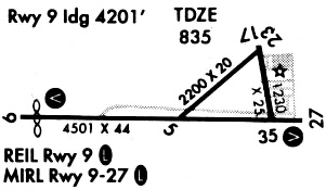
Runways
Runway Summary
| Runways: | 05/23 09/27 |
| Longest Runway: | 09/27 is 4507 ft (1374 m) long |
| Runways with an Instrument Approach: |
3GV Airport Runway Details
| Runway 05/23 | 2206 ft x 20 ft (672 m x 6 m) | |
| Runway Length Source: | FAA as of 08/09/2011 | |
| Surface: | Asphalt - Excellent condition - No special surface treatment | |
Runway Weight Bearing Capacity (in thousands of pounds) |
||
| Single Wheel Landing Gear: | 11.0 | |
Runway 05 |
Runway 23 |
|
Elevation: |
818.1 | 833.4 |
Latitude: |
39-00-50.6600N | 39-01-02.4500N |
Longitude: |
094-12-59.2000W | 094-12-35.6900W |
|
Runway True Alignment: |
057 | 237 |
Glide Path Angle: |
0.0 degrees | 0.0 degrees |
Traffic Pattern: |
Right | |
Runway Markings Type: |
Basic | Basic |
Runway Markings Condition: |
Good | Good |
Object at End: |
TREES | TREES |
Object Height: |
32 | 56 |
Distance from End: |
230 | 656 |
Object Centerline Offset: |
90 ft. right of centerline | 207 ft. right of centerline |
| Runway 09/27 | 4507 ft x 44 ft (1374 m x 13 m) | |
| Runway Length Source: | FAA as of 08/09/2011 | |
| Surface: | Asphalt - Excellent condition - No special surface treatment | |
| Runway Edge Lights: | Medium Intensity | |
Runway Weight Bearing Capacity (in thousands of pounds) |
||
| Single Wheel Landing Gear: | 11.0 | |
Runway 09 |
Runway 27 |
|
Elevation: |
817.0 | 817.9 |
Latitude: |
39-00-51.3200N | 39-00-50.3300N |
Longitude: |
094-13-24.9900W | 094-12-27.9100W |
|
Runway True Alignment: |
091 | 271 |
Glide Path Angle: |
0.0 degrees | 0.0 degrees |
Traffic Pattern: |
Right | |
Runway Markings Type: |
Nonprecision Instrument | Nonprecision Instrument |
Runway Markings Condition: |
Good | Good |
Object at End: |
RR | RR |
Object Height: |
23 | 15 |
Distance from End: |
201 | 201 |
Object Centerline Offset: |
90 ft. right of centerline | 207 ft. right of centerline |
REIL: |
Yes | |
Threshold Elevation: |
817.4 | |
Displaced Threshold: |
303 | |
Threshold Latitude: |
39-00-51.2500N | |
Threshold Longitude: |
094-13-21.1500W |
Services
Airframe Repair: |
Major |
Powerplant Repair: |
Major |
Bulk Oxygen: |
None |
Fuel Available: |
100LL, Jet A |
Landing Fees: |
No |
Parking: |
Tiedowns available |
Maps & Diagrams
3GV Sectional
Flight Planning
at skyvector.com
at skyvector.com