Location
Latitude: |
39-19-57.0280N (39.332508) |
Longitude: |
094-18-34.7330W (-94.309648) |
Elevation: |
777.2 feet MSL (237 m MSL) |
Magnetic Variation: |
1 E (as of April 2024 from WMM2020 model) |
Time Zone: |
UTC -6.0 (Standard Time) UTC -5.0 (Daylight Savings Time) |
From City: |
01 N.M. N of Mosby, Missouri |
Found On: |
Kansas City Chart |
FAA Region: |
ACE |
Contacts
Manager: |
Publicly owned: |
| JOHN DAVIS 13106 RHODUS RD EXCELSIOR SPRINGS, MO 64024 816-407-3396 |
CLAY COUNTY COMMISSION 1 COURTHOUSE SQUARE LIBERTY, MO 64068 816-407-3390 |
Operations
Airport Status: |
Operational |
Facility Use: |
Public |
Type: |
Airport |
Control tower: |
No |
Attendance (Months/Days/Hours): |
Months/Days/Hours ALL/MON-FRI/0800-1600 |
Boundary ARTCC: |
ZKC (Kansas City) |
Responsible ARTCC: |
ZKC (Kansas City) |
Lighting Schedule: |
SEE RMK |
Segmented Circle Indicator: |
Yes |
Traffic Pattern Altitude (MSL): |
1777 feet (542 m) |
NOTAMs Facility: |
COU |
NOTAM-D Service: |
Yes |
Based Aircraft
| Single Engine: | 57 |
| Multi Engine: | 16 |
| Jet Engine: | 1 |
| GA Helicopters: | 2 |
| Gliders: | 1 |
Annual Operations (as of 12/31/2021)
| Total Operations: | 44550 | |
| Air Taxi: | 2040 | 4.6% |
| GA Local: | 28460 | 63.9% |
| GA Itinerant: | 14000 | 31.4% |
| Military Aircraft: | 50 | 0.1% |
Communications
| CTAF: | 122.700 |
| Unicom: | 122.700 |
| Approach: | KANSAS CITY |
| Departure: | KANSAS CITY |
| AWOS-3T: | 120.275 (816-407-3399) |
Fixed Based Operators (FBOs) & Fuel
(Click on a business for detail)
Please help us keep this information up to date. This is a FREE SERVICE just like everything else on Airport Guide! If you see that a business needs to be added, modified, or deleted please fill out our Update Form.
To add, modify, or delete a business click here.
Please help us keep this information up to date. This is a FREE SERVICE just like everything else on Airport Guide! If you see that a business needs to be added, modified, or deleted please fill out our Update Form.
Area Code: 816 |
| Business Name | Frequency | Phone | Fuel Grade |
|---|---|---|---|
| Clay County
Update FBO info |
628-2286 | 80, 100LL, Jet A |
Flight Service Stations
| Primary | Alternate | |
| FSS on Field: | N | |
| FSS Name (ID): | Columbia(COU) | |
| Frequency: | ||
| Toll Free Phone: | 1-800-WX-BRIEF |
Instrument Procedures / Charts
FAA Terminal Procedures valid from 0901Z 03/21/24 to 0901Z 04/18/24.
There are various types of charts available for an airport. They are listed in the Page Type column. Here is a legend for those types:
APD - Airport Diagram
DP - Departure Procedure Charts
HOT - Hot Spots
IAP - Instrument Approach Procedure Charts
MIN - Minimums
STAR - Standard Terminal Arrival Charts
| Page Type | Page Name | Volume | Action Since Last Cycle |
|---|---|---|---|
| DP | CHIEF NINE | NC-3 | |
| DP | LAKES FIVE | NC-3 | |
| DP | RACER EIGHT | NC-3 | |
| DP | ROYAL ONE | NC-3 | |
| DP | TIFTO EIGHT | NC-3 | |
| DP | WILDCAT SIX | NC-3 | |
| IAP | ILS OR LOC/DME RWY 18 | NC-3 | |
| IAP | RNAV (GPS) RWY 18 | NC-3 | |
| IAP | RNAV (GPS) RWY 36 | NC-3 | |
| MIN | ALTERNATE MINIMUMS | NC-3 | |
| MIN | TAKEOFF MINIMUMS | NC-3 | |
| STAR | BRAYMER EIGHT | NC-3 | |
| STAR | BRAYMER EIGHT[DELIMITER] CONT.1 | NC-3 | |
| STAR | JHAWK SEVEN | NC-3 | |
| STAR | TYGER SEVEN | NC-3 | |
| STAR | TYGER SEVEN[DELIMITER] CONT.1 | NC-3 |
Terminal Procedures are only available for airports in several countries with more being added all the time. If you are looking for a specific country's charts, please send an email to support(at)airportguide.com stating the country name. This will be used to prioritize the implementation.
Navigation Aids (Navaids) near KGPH
| Dist (NM) | ID | Morse Code | Name | Type | Freq | True Hdg | Mag Hdg |
|---|---|---|---|---|---|---|---|
| 16.5 | ANX | . _ _ . _ . . _ | Napoleon | VORTAC | 114.00 | 149 | 148 |
| 18.4 | MKC | _ _ _ . _ _ . _ . | Kansas City Downtown | VOT | 108.60 | 226 | 225 |
| 18.4 | RIS | . _ . . . . . . | Riverside | VOR-DME | 111.40 | 226 | 225 |
| 20.0 | MCI | _ _ _ . _ . . . | Kansas City | VORTAC | 113.25 | 262 | 261 |
| 21.5 | DO | _ . . _ _ _ | Dotte | NDB | 359 | 252 | 251 |
| 22.9 | GQ | _ _ . _ _ . _ | Norge | NDB | 517 | 224 | 223 |
| 26.9 | BQS | _ . . . _ _ . _ . . . | Braymer | VOR-DME | 115.35 | 48 | 47 |
| 34.5 | ST | . . . _ | Tario | NDB | 260 | 306 | 305 |
| 35.6 | OJC | _ _ _ . _ _ _ _ . _ . | Johnson County | VOR-DME | 113.00 | 214 | 213 |
| 40.1 | PK | . _ _ . _ . _ | Herbb | NDB | 420 | 209 | 208 |
| 43.1 | AZN | . _ _ _ . . _ . | Amazon | NDB | 233 | 320 | 319 |
| 46.2 | CHT | _ . _ . . . . . _ | Chillicothe | NDB | 375 | 54 | 53 |
| 46.6 | JZ | . _ _ _ _ _ . . | Newbn | NDB | 338 | 237 | 236 |
| 47.2 | STJ | . . . _ . _ _ _ | St Joseph | VORTAC | 115.50 | 323 | 322 |
| 50.3 | SZL | . . . _ _ . . . _ . . | Whiteman | TACAN | 109.80 | 135 | 134 |
| 54.7 | PUR | . _ _ . . . _ . _ . | Marshall | NDB | 371 | 108 | 107 |
| 55.7 | TRX | _ . _ . _ . . _ | Trenton | NDB | 400 | 36 | 35 |
| 58.8 | TOP | _ _ _ _ . _ _ . | Topeka | VORTAC | 117.80 | 258 | 257 |
| 60.2 | RBA | . _ . _ . . . . _ | Robinson | DME | 108.2 | 301 | 300 |
| 61.3 | BZK | _ . . . _ _ . . _ . _ | Brookfield | NDB | 383 | 64 | 63 |
Nearby Airports with Fuel
Notices to Airmen (NOTAMS)
Remarks
| A110-1 | ARPT TERMINAL BLDG OPEN 24 HRS. |
| A110-2 | CONFIRM SNOW REMOVAL AND WINTER CONDITIONS DURING NOV-MAR, CALL 816-407-3390. |
| A110-3 | FLOCKS OF DUCKS; GEESE & OTHER WILDLIFE ON AND INVOF ARPT. |
| A110-4 | FOR CD CTC KANSAS CITY APCH AT 816-329-2710. |
| A17 | AFTER HOURS AND WEEKENDS ON CALL 816-905-2736 |
| A39-18/36 | 156 IS PCR. |
| A70-FUEL-A+ | 24 HR CREDIT CARD FUELING SYSTEM AVBL FOR JET-A & 100LL. FOR AFTER HRS FULL SVC FUELING CALL 816-407-3390. AFTER HRS CALL OUT FEE WAIVED WITH 200 GAL OR MORE FUEL PURCHASE. |
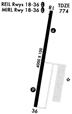
| A81-APT | ACTVT HIRL RY 18/36; PAPI RYS 18 & 36; REIL RYS 18 & 36 - CTAF. |
| E111 | PRVDD CLEAR APCH TO EACH RY FOR A 20:1 GLIDE SLOPE; CLEAR TRANSITIONAL SFC FOR A 7:1 SLOPE; USE STD L TFC RY 18; R TFC RY 36 & USE SAME UNICOM FREQ AS OTR ARPTS IN AREA. |
Runways
Runway Summary
| Runways: | 18/36 |
| Longest Runway: | 18/36 is 5502 ft (1677 m) long |
| Runways with an Instrument Approach: | 18 |
KGPH Airport Runway Details
| Runway 18/36 | 5502 ft x 100 ft (1677 m x 30 m) | |
| Runway Length Source: | 3RD PARTY SURVEY as of 11/16/2018 | |
| Surface: | Asphalt - Good condition - No special surface treatment | |
| Runway Pavement Class: | 156/F/D/X/T | |
| Runway Edge Lights: | High Intensity | |
Runway Weight Bearing Capacity (in thousands of pounds) |
||
| Single Wheel Landing Gear: | 30.0 | |
| Dual Wheel Landing Gear: | 60.0 | |
Runway 18 |
Runway 36 |
|
Elevation: |
777.1 | 774.8 |
Latitude: |
39-20-24.0053N | 39-19-30.0509N |
Longitude: |
094-18-30.3913W | 094-18-39.0736W |
|
Runway True Alignment: |
187 | 007 |
ILS Type: |
ILS/DME | |
Glide Path Angle: |
3.5 degrees | 3.0 degrees |
Traffic Pattern: |
Left | |
Runway Markings Type: |
Precision Instrument | Nonprecision Instrument |
Runway Markings Condition: |
Good | Good |
Visual Glide Slope Indicators: |
4-Light PAPI On Left Side Of Runway | 4-Light PAPI On Left Side Of Runway |
REIL: |
Yes | Yes |
Threshold Crossing Height: |
59 | 45 |
Services
Fuel Available: |
100LL |
Landing Fees: |
No |
Parking: |
Tiedowns available |
Maps & Diagrams
KGPH Sectional
Flight Planning
at skyvector.com
at skyvector.com