Location
Latitude: |
35-23-57.1000N (35.399194) |
Longitude: |
084-33-42.4000W (-84.561778) |
Elevation: |
874.3 feet MSL (266 m MSL) |
Magnetic Variation: |
5.6 W (as of April 2024 from WMM2020 model) |
Time Zone: |
UTC -5.0 (Standard Time) UTC -4.0 (Daylight Savings Time) |
From City: |
03 N.M. SE of Athens, Tennessee |
Found On: |
Atlanta Chart |
FAA Region: |
ASO |
Contacts
Manager: |
Publicly owned: |
| KRISTY GENTRY COX 195 COUNTY ROAD 552 ATHENS, TN 37303 423-745-4939 |
MCMINN COUNTY COUNTY COURTHOUSE, 6 EAST MADISON AVENUE ATHENS, TN 37303 423-745-7634 |
Operations
Airport Status: |
Operational |
Facility Use: |
Public |
Type: |
Airport |
Activation Date: |
09/1951 |
Control tower: |
No |
Attendance (Months/Days/Hours): |
Months/Days/Hours ALL/SUN/1230-1700 |
Boundary ARTCC: |
ZTL (Atlanta) |
Responsible ARTCC: |
ZTL (Atlanta) |
Lighting Schedule: |
SS-SR |
Segmented Circle Indicator: |
Yes |
Traffic Pattern Altitude (MSL): |
1874 feet (571 m) |
NOTAMs Facility: |
BNA |
NOTAM-D Service: |
Yes |
International Airport of Entry: |
No |
Customs Landing Rights: |
No |
Military Landing Rights: |
Yes |
Civil/Military Joint Use: |
No |
Based Aircraft
| Single Engine: | 35 |
| Multi Engine: | 2 |
| Jet Engine: | 1 |
| GA Helicopters: | 1 |
Annual Operations (as of 06/22/2023)
| Total Operations: | 22575 | |
| Air Taxi: | 1500 | 6.6% |
| GA Local: | 15000 | 66.4% |
| GA Itinerant: | 6000 | 26.6% |
| Military Aircraft: | 75 | 0.3% |
Communications
| CTAF: | 122.800 |
| Unicom: | 122.800 |
| Approach: | KNOXVILLE 123.9 123.9 |
| Departure: | KNOXVILLE 123.9 123.9 |
| AWOS-3: | 125.425 (423-745-3422) |
Fixed Based Operators (FBOs) & Fuel
(Click on a business for detail)
Please help us keep this information up to date. This is a FREE SERVICE just like everything else on Airport Guide! If you see that a business needs to be added, modified, or deleted please fill out our Update Form.
To add, modify, or delete a business click here.
Please help us keep this information up to date. This is a FREE SERVICE just like everything else on Airport Guide! If you see that a business needs to be added, modified, or deleted please fill out our Update Form.
Area Code: 423 |
| Business Name | Frequency | Phone | Fuel Grade |
|---|---|---|---|
| McMinn County Aviation, Inc.
Update FBO info |
Unicom 122.8 | 745-4939 | 100LL, Mogas, Jet A |
Flight Service Stations
| Primary | Alternate | |
| FSS on Field: | N | |
| FSS Name (ID): | Nashville(BNA) | |
| Frequency: | ||
| Toll Free Phone: | 1-800-WX-BRIEF |
Instrument Procedures / Charts
FAA Terminal Procedures valid from 0901Z 03/21/24 to 0901Z 04/18/24.
There are various types of charts available for an airport. They are listed in the Page Type column. Here is a legend for those types:
APD - Airport Diagram
DP - Departure Procedure Charts
HOT - Hot Spots
IAP - Instrument Approach Procedure Charts
MIN - Minimums
STAR - Standard Terminal Arrival Charts
| Page Type | Page Name | Volume | Action Since Last Cycle |
|---|---|---|---|
| IAP | RNAV (GPS) RWY 02 | SE-1 | |
| IAP | RNAV (GPS) RWY 20 | SE-1 | |
| MIN | ALTERNATE MINIMUMS | SE-1 | |
| MIN | TAKEOFF MINIMUMS | SE-1 |
Terminal Procedures are only available for airports in several countries with more being added all the time. If you are looking for a specific country's charts, please send an email to support(at)airportguide.com stating the country name. This will be used to prioritize the implementation.
Navigation Aids (Navaids) near MMI
| Dist (NM) | ID | Morse Code | Name | Type | Freq | True Hdg | Mag Hdg |
|---|---|---|---|---|---|---|---|
| 0.3 | MMI | _ _ _ _ . . | Mc Minn County | NDB | 242 | 178 | 184 |
| 12.4 | MNV | _ _ _ . . . . _ | Madisonville | NDB | 361 | 44 | 50 |
| 18.7 | DTE | _ . . _ . | Mark Anton | NDB | 394 | 285 | 290 |
| 22.4 | HDI | . . . . _ . . . . | Hardwick | NDB | 369 | 228 | 233 |
| 30.6 | HCH | . . . . _ . _ . . . . . | Hinch Mountain | VOR-DME | 117.60 | 318 | 323 |
| 32.3 | CQN | _ . _ . _ _ . _ _ . | Daisy | NDB | 341 | 244 | 249 |
| 37.3 | TYS | _ _ . _ _ . . . | Knoxville | VOT | 112.00 | 47 | 53 |
| 39.1 | GQO | _ _ . _ _ . _ _ _ _ | Choo Choo | DME | 115.8 | 228 | 233 |
| 41.0 | UWI | . . _ . _ _ . . | Whitfield | NDB | 400 | 207 | 212 |
| 41.9 | HRS | . . . . . _ . . . . | Harris | VORTAC | 109.80 | 130 | 136 |
| 44.5 | VXV | . . . _ _ . . _ . . . _ | Volunteer | VORTAC | 116.40 | 46 | 52 |
| 54.1 | APT | . _ . _ _ . _ | Jasper | NDB | 382 | 248 | 253 |
| 61.2 | HEM | . . . . . _ _ | Huchn | NDB | 233 | 305 | 310 |
| 62.4 | RN | . _ . _ . | Warri | NDB | 209 | 290 | 295 |
| 62.5 | OUK | _ _ _ . . _ _ . _ | Calhoun | NDB | 323 | 196 | 201 |
| 68.0 | JXT | . _ _ _ _ . . _ _ | Jefferson | NDB | 346 | 50 | 56 |
| 68.5 | BPO | _ . . . . _ _ . _ _ _ | Piney Grove | NDB | 403 | 3 | 9 |
| 68.9 | DJD | _ . . . _ _ _ _ . . | Chero | NDB | 415 | 176 | 182 |
| 70.1 | SKN | . . . _ . _ _ . | Hurricane | NDB | 256 | 300 | 305 |
| 73.3 | EVZ | . . . . _ _ _ . . | Cartersville | NDB | 308 | 190 | 195 |
Nearby Airports with Fuel
Notices to Airmen (NOTAMS)
Remarks
| A110-1 | WILDLIFE ON & INVOF ARPT. |
| A110-2 | FOR CD CTC KNOXVILLE APCH AT 865-980-3034; IF UNA FOR CD CTC KNOXVILLE APCH AT 865-980-3033. |
| A17 | CLD EASTER, THANKSGIVING & CHRISTMAS. |
| A42-02 | FADED. |
| A42-20 | FADED. |
| A43-02 | PAPI UNUSBL BYD 7 DEGS LEFT OF CNTRLN. |
| A57-02 | APCH SLOPE 36:1 TO DTHR. |
Runways
Runway Summary
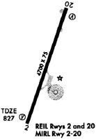
| Runways: | 02/20 |
| Longest Runway: | 02/20 is 6450 ft (1966 m) long |
| Runways with an Instrument Approach: |
MMI Airport Runway Details
| Runway 02/20 | 6450 ft x 100 ft (1966 m x 30 m) | |
| Runway Length Source: | OWNER as of 04/01/2009 | |
| Surface: | Asphalt - Good condition - No special surface treatment | |
| Runway Pavement Class: | 15 /F/D/X/T | |
| Runway Edge Lights: | Medium Intensity | |
Runway Weight Bearing Capacity (in thousands of pounds) |
||
| Single Wheel Landing Gear: | 30.0 | |
| Dual Wheel Landing Gear: | 42.0 | |
Runway 02 |
Runway 20 |
|
Elevation: |
806.5 | 874.3 |
Latitude: |
35-23-26.8800N | 35-24-27.3000N |
Longitude: |
084-33-54.9300W | 084-33-29.9400W |
|
Runway True Alignment: |
019 | 199 |
Glide Path Angle: |
3.0 degrees | 3.0 degrees |
Traffic Pattern: |
Left | Left |
Runway Markings Type: |
Nonprecision Instrument | Nonprecision Instrument |
Runway Markings Condition: |
Poor | Poor |
Object at End: |
TREES | TREES |
Object Height: |
74 | 68 |
Distance from End: |
1189 | 1522 |
Object Centerline Offset: |
137 ft. left of centerline | 157 ft. left of centerline |
Visual Glide Slope Indicators: |
2-Light PAPI On Left Side Of Runway | 2-Light PAPI On Left Side Of Runway |
REIL: |
Yes | Yes |
Threshold Crossing Height: |
41 | 41 |
Threshold Elevation: |
811.3 | |
Displaced Threshold: |
949 | |
Threshold Latitude: |
35-23-35.7800N | |
Threshold Longitude: |
084-33-51.2500W |
Services
Airframe Repair: |
Major |
Powerplant Repair: |
Major |
Bottled Oxygen: |
High Pressure / Low Pressure |
Bulk Oxygen: |
High Pressure / Low Pressure |
Fuel Available: |
100LL, Jet A+ |
Landing Fees: |
No |
Parking: |
Tiedowns available |
Maps & Diagrams
MMI Sectional
Flight Planning
at skyvector.com
at skyvector.com