Location
Latitude: |
35-39-15.2000N (35.654222) |
Longitude: |
105-08-32.6000W (-105.142389) |
Elevation: |
6877.2 feet MSL (2096 m MSL) |
Magnetic Variation: |
7.3 E (as of May 2024 from WMM2020 model) |
Time Zone: |
UTC -7.0 (Standard Time) UTC -6.0 (Daylight Savings Time) |
From City: |
05 N.M. NE of Las Vegas, New Mexico |
Found On: |
Albuquerque Chart |
FAA Region: |
ASW |
Contacts
Manager: |
Publicly owned: |
| JOHN ARAGON 910 AIRPORT ROAD LAS VEGAS, NM 87701 505-454-0881 |
CITY OF LAS VEGAS 1700 NORTH GRAND LAS VEGAS, NM 87701 505-454-1401 |
Operations
Airport Status: |
Operational |
Facility Use: |
Public |
Type: |
Airport |
Activation Date: |
12/1946 |
Control tower: |
No |
Attendance (Months/Days/Hours): |
Months/Days/Hours ALL/MON-FRI/0800-1700 |
Boundary ARTCC: |
ZAB (Albuquerque) |
Responsible ARTCC: |
ZAB (Albuquerque) |
Lighting Schedule: |
SEE RMK |
Segmented Circle Indicator: |
Yes |
Traffic Pattern Altitude (MSL): |
7877 feet (2401 m) |
NOTAMs Facility: |
LVS |
NOTAM-D Service: |
Yes |
International Airport of Entry: |
No |
Customs Landing Rights: |
No |
Military Landing Rights: |
Yes |
Civil/Military Joint Use: |
No |
Based Aircraft
| Single Engine: | 3 |
| Jet Engine: | 1 |
Annual Operations (as of 03/31/2021)
| Total Operations: | 11500 | |
| GA Local: | 4000 | 34.8% |
| GA Itinerant: | 7000 | 60.9% |
| Military Aircraft: | 500 | 4.3% |
Communications
| CTAF: | 122.800 |
| Unicom: | 122.800 |
| ASOS: | 118.525 (505-454-4645) |
- APCH/DEP SVC PRVDD BY ALBUQUERQUE ARTCC (ZAB) ON FREQS 132.8/346.35 (SANDIA MOUNTAIN RCAG).
Fixed Based Operators (FBOs) & Fuel
(Click on a business for detail)
Please help us keep this information up to date. This is a FREE SERVICE just like everything else on Airport Guide! If you see that a business needs to be added, modified, or deleted please fill out our Update Form.
To add, modify, or delete a business click here.
Please help us keep this information up to date. This is a FREE SERVICE just like everything else on Airport Guide! If you see that a business needs to be added, modified, or deleted please fill out our Update Form.
Area Code: 505 |
| Business Name | Frequency | Phone | Fuel Grade |
|---|---|---|---|
| Crowell Aviation
Update FBO info |
Unicom 122.8 | 454-0881, after hours in emergency call 454-0881 or 425-5794 | 100LL, Jet A |
Flight Service Stations
| Primary | Alternate | |
| FSS on Field: | N | |
| FSS Name (ID): | Albuquerque(ABQ) | |
| Frequency: | ||
| Toll Free Phone: | 1-800-WX-BRIEF |
Instrument Procedures / Charts
FAA Terminal Procedures valid from 0901Z 03/21/24 to 0901Z 04/18/24.
There are various types of charts available for an airport. They are listed in the Page Type column. Here is a legend for those types:
APD - Airport Diagram
DP - Departure Procedure Charts
HOT - Hot Spots
IAP - Instrument Approach Procedure Charts
MIN - Minimums
STAR - Standard Terminal Arrival Charts
| Page Type | Page Name | Volume | Action Since Last Cycle |
|---|---|---|---|
| IAP | RNAV (GPS) RWY 02 | SW-1 | |
| IAP | RNAV (GPS) RWY 20 | SW-1 | |
| IAP | RNAV (GPS) RWY 32 | SW-1 | |
| IAP | VOR RWY 20 | SW-1 | |
| MIN | ALTERNATE MINIMUMS | SW-1 | |
| MIN | TAKEOFF MINIMUMS | SW-1 |
Terminal Procedures are only available for airports in several countries with more being added all the time. If you are looking for a specific country's charts, please send an email to support(at)airportguide.com stating the country name. This will be used to prioritize the implementation.
Navigation Aids (Navaids) near LVS
| Dist (NM) | ID | Morse Code | Name | Type | Freq | True Hdg | Mag Hdg |
|---|---|---|---|---|---|---|---|
| 0.4 | FTI | . . _ . _ . . | Fort Union | VORTAC | 117.30 | 59 | 52 |
| 32.9 | ACH | . _ _ . _ . . . . . | Anton Chico | VORTAC | 117.80 | 171 | 164 |
| 45.5 | SAF | . . . . _ . . _ . | Santa Fe | VORTAC | 110.60 | 261 | 254 |
| 49.0 | SG | . . . _ _ . | Doman | NDB | 341 | 263 | 255 |
| 51.9 | CIM | _ . _ . . . _ _ | Cimarron | VORTAC | 116.40 | 14 | 7 |
| 52.2 | OTO | _ _ _ _ _ _ _ | Otto | VOR | 114.00 | 228 | 221 |
| 68.2 | TAS | _ . _ . . . | Taos | VORTAC | 115.80 | 327 | 319 |
| 80.6 | TCC | _ _ . _ . _ . _ . | Tucumcari | VORTAC | 113.60 | 110 | 103 |
| 80.7 | ABQ | . _ _ . . . _ _ . _ | Albuquerque | VOT | 111.00 | 243 | 235 |
| 81.1 | AE | . _ . | Dudle | NDB | 351 | 251 | 243 |
| 81.6 | CNX | _ . _ . _ . _ . . _ | Corona | VORTAC | 115.50 | 198 | 191 |
| 89.7 | ABQ | . _ _ . . . _ _ . _ | Albuquerque | VORTAC | 113.20 | 246 | 238 |
Nearby Airports with Fuel
| Dist (NM) | Name (Airport IDs) | True Hdg | Mag Hdg | Fuel Grade |
|---|---|---|---|---|
| 0.0 | Las Vegas Municipal Airport (LVS KLVS LVS) |
0 | 353 | 100LL, Jet A-1 |
| 46.2 | Santa Fe Regional Airport (SAF KSAF SAF) |
267 | 259 | 100LL, Jet A, Jet A+ |
| 46.6 | Angel Fire Airport (AXX KAXX AXX) |
351 | 344 | 100LL, Jet A+ |
| 49.6 | Santa Rosa Route 66 Airport (KSXU SXU) |
150 | 143 | 100LL, Jet A |
| 54.3 | Taos Regional Airport (TSM KSKX SKX) |
331 | 323 | 100LL, Jet A-1+ |
| 56.5 | Los Alamos Airport (LAM KLAM LAM) |
284 | 276 | 100LL |
| 58.4 | Moriarty Municipal Airport (0E0) |
226 | 218 | 100LL, Jet A |
| 60.2 | Sandia Airpark Estates East Airport (1N1) |
236 | 228 | 100LL |
| 72.3 | Raton Municipal/Crews Field Airport (RTN KRTN RTN) |
25 | 18 | 100LL, Jet A-1+ |
| 80.4 | Tucumcari Municipal Airport (TCC KTCC TCC) |
110 | 104 | 100LL, Jet A+ |
| 80.7 | Albuquerque International Sunport Airport (ABQ KABQ ABQ) |
243 | 235 | 100LL, Jet A, Jet A-1, Jet A-1+ |
| 83.4 | Fort Sumner Municipal Airport (FSU KFSU FSU) |
146 | 139 | 100LL |
| 86.4 | Double Eagle Ii Airport (KAEG AEG) |
249 | 241 | 100LL, Jet A-1 |
| 95.1 | Mid Valley Airpark Airport (E98) |
236 | 228 | 100LL |
Notices to Airmen (NOTAMS)
Remarks
| A110-2 | BE ALERT FOR HEAVY CONCENTRATIONS OF BIRDS ON & INVOF ARPT. |
| A110-4 | NUMEROUS AIRPORT HOLD AN DIRECTIONAL SIGNS OUT OF SERVICE INDEFINITELY. |
| A110-5 | FOR CD IF UNA TO CTC ON FSS FREQ, CTC ALBUQUERQUE ARTCC AT 505-856-4561. |
| A17 | IF ARPT ATTENDANT UNAVBL CALL 505-429-3198 (EMERGENCY) OR LAS VEGAS POLICE DISPATCH AT 505-425-7504. |
| A49-02 | NSTD ODALS OUT OF SERVICE INDEFINITELY. |
| A49-20 | NSTD ODALS - OUT OF SERVICE INDEFINITELY. |
| A70-FUEL-10 | 0LL FUEL AVBL 24 HRS SELF-SERVICE WITH MAJOR CREDIT CARD. |
| A81-APT | ACTVT PAPI RWY 02, 20, 14, 32; MIRL RWY 02/20 & 14/32 - CTAF. |
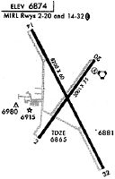
Runways
Runway Summary
| Runways: | 02/20 14/32 |
| Longest Runway: | 14/32 is 8199 ft (2499 m) long |
| Runways with an Instrument Approach: |
LVS Airport Runway Details
| Runway 02/20 | 5006 ft x 75 ft (1526 m x 23 m) | |
| Runway Length Source: | 3RD PARTY SURVEY as of 06/19/2011 | |
| Surface: | Asphalt - Good condition - No special surface treatment | |
| Runway Pavement Class: | 8 /F/D/X/T | |
| Runway Edge Lights: | Medium Intensity | |
Runway Weight Bearing Capacity (in thousands of pounds) |
||
| Single Wheel Landing Gear: | 20.0 | |
Runway 02 |
Runway 20 |
|
Elevation: |
6866.0 | 6860.5 |
Latitude: |
35-38-53.7555N | 35-39-34.3340N |
Longitude: |
105-08-50.7306W | 105-08-16.0247W |
|
Runway True Alignment: |
035 | 215 |
Glide Path Angle: |
3.0 degrees | 3.0 degrees |
Traffic Pattern: |
Left | Left |
Runway Markings Type: |
Nonprecision Instrument | Nonprecision Instrument |
Runway Markings Condition: |
Good | Good |
Visual Glide Slope Indicators: |
2-Light PAPI On Left Side Of Runway | 2-Light PAPI On Left Side Of Runway |
Approach Light System: |
Omnidirectional Approach Lighting System | Omnidirectional Approach Lighting System |
Threshold Crossing Height: |
40 | 40 |
| Runway 14/32 | 8199 ft x 75 ft (2499 m x 23 m) | |
| Runway Length Source: | 3RD PARTY SURVEY as of 06/19/2011 | |
| Surface: | Asphalt - Good condition - No special surface treatment | |
| Runway Pavement Class: | 7 /F/D/X/T | |
| Runway Edge Lights: | Medium Intensity | |
Runway Weight Bearing Capacity (in thousands of pounds) |
||
| Single Wheel Landing Gear: | 20.0 | |
Runway 14 |
Runway 32 |
|
Elevation: |
6839.9 | 6877.2 |
Latitude: |
35-39-51.5175N | 35-38-40.1823N |
Longitude: |
105-08-55.7741W | 105-08-08.6010W |
|
Runway True Alignment: |
152 | 332 |
Glide Path Angle: |
3.0 degrees | 3.0 degrees |
Traffic Pattern: |
Left | Left |
Runway Markings Type: |
Nonprecision Instrument | Nonprecision Instrument |
Runway Markings Condition: |
Good | Good |
Visual Glide Slope Indicators: |
2-Light PAPI On Left Side Of Runway | 2-Light PAPI On Left Side Of Runway |
Threshold Crossing Height: |
41 | 36 |
Services
Airframe Repair: |
Major |
Powerplant Repair: |
Major |
Fuel Available: |
100LL |
Maps & Diagrams
LVS Sectional
Flight Planning
at skyvector.com
at skyvector.com