Location
Latitude: |
36-44-32.7810N (36.742439) |
Longitude: |
104-30-06.2150W (-104.501726) |
Elevation: |
6352.4 feet MSL (1936 m MSL) |
Magnetic Variation: |
7.1 E (as of April 2024 from WMM2020 model) |
Time Zone: |
UTC -7.0 (Standard Time) UTC -6.0 (Daylight Savings Time) |
From City: |
10 N.M. SW of Raton, New Mexico |
Found On: |
Denver Chart |
FAA Region: |
ASW |
Contacts
Manager: |
Publicly owned: |
| DUSTY LONGWILL HCR 62 BOX 19 RATON, NM 87740 575-445-3076 |
CITY OF RATON BOX 19 RATON, NM 87740 575-445-9551 |
Operations
Airport Status: |
Operational |
Facility Use: |
Public |
Type: |
Airport |
Control tower: |
No |
Attendance (Months/Days/Hours): |
Months/Days/Hours ALL/ALL/0700-1700 |
Boundary ARTCC: |
ZAB (Albuquerque) |
Responsible ARTCC: |
ZAB (Albuquerque) |
Lighting Schedule: |
SEE RMK |
Segmented Circle Indicator: |
Yes |
Traffic Pattern Altitude (MSL): |
7352 feet (2241 m) |
NOTAMs Facility: |
RTN |
NOTAM-D Service: |
Yes |
International Airport of Entry: |
No |
Customs Landing Rights: |
No |
Military Landing Rights: |
Yes |
Civil/Military Joint Use: |
No |
Based Aircraft
| Single Engine: | 16 |
Annual Operations (as of 04/22/2022)
| Total Operations: | 7000 | |
| Air Taxi: | 400 | 5.7% |
| GA Local: | 2000 | 28.6% |
| GA Itinerant: | 3800 | 54.3% |
| Military Aircraft: | 800 | 11.4% |
Communications
| CTAF: | 122.800 |
| Unicom: | 122.800 |
| ASOS: | 118.375 (575-445-7624) |
- APCH/DEP SVC PRVDD BY ALBUQUERQUE ARTCC ON FREQS 132.8/346.35 (RATON RCAG).
Fixed Based Operators (FBOs) & Fuel
(Click on a business for detail)
Please help us keep this information up to date. This is a FREE SERVICE just like everything else on Airport Guide! If you see that a business needs to be added, modified, or deleted please fill out our Update Form.
To add, modify, or delete a business click here.
Please help us keep this information up to date. This is a FREE SERVICE just like everything else on Airport Guide! If you see that a business needs to be added, modified, or deleted please fill out our Update Form.
Area Code: 505 |
| Business Name | Frequency | Phone | Fuel Grade |
|---|---|---|---|
| Pegasus Aviation
Update FBO info |
Unicom 122.8 (0700-1730) | 445-3076, after hours call 445-2569 | 100LL, Jet A |
Flight Service Stations
| Primary | Alternate | |
| FSS on Field: | N | |
| FSS Name (ID): | Albuquerque(ABQ) | |
| Frequency: | ||
| Toll Free Phone: | 1-800-WX-BRIEF |
Instrument Procedures / Charts
FAA Terminal Procedures valid from 0901Z 03/21/24 to 0901Z 04/18/24.
There are various types of charts available for an airport. They are listed in the Page Type column. Here is a legend for those types:
APD - Airport Diagram
DP - Departure Procedure Charts
HOT - Hot Spots
IAP - Instrument Approach Procedure Charts
MIN - Minimums
STAR - Standard Terminal Arrival Charts
| Page Type | Page Name | Volume | Action Since Last Cycle |
|---|---|---|---|
| IAP | RNAV (GPS) RWY 02 | SW-1 | |
| IAP | RNAV (GPS) RWY 25 | SW-1 | |
| MIN | ALTERNATE MINIMUMS | SW-1 | |
| MIN | TAKEOFF MINIMUMS | SW-1 |
Terminal Procedures are only available for airports in several countries with more being added all the time. If you are looking for a specific country's charts, please send an email to support(at)airportguide.com stating the country name. This will be used to prioritize the implementation.
Navigation Aids (Navaids) near RTN
| Dist (NM) | ID | Morse Code | Name | Type | Freq | True Hdg | Mag Hdg |
|---|---|---|---|---|---|---|---|
| 23.3 | CIM | _ . _ . . . _ _ | Cimarron | VORTAC | 116.40 | 229 | 222 |
| 34.8 | TAD | _ . _ _ . . | Trinidad | NDB | 329 | 13 | 6 |
| 53.2 | TBE | _ _ . . . . | Tobe | VOR-DME | 114.05 | 54 | 47 |
| 67.6 | CAO | _ . _ . . _ _ _ _ | Clayton | NDB | 332 | 104 | 97 |
| 68.1 | TAS | _ . _ . . . | Taos | VORTAC | 115.80 | 263 | 256 |
| 72.0 | FTI | . . _ . _ . . | Fort Union | VORTAC | 117.30 | 205 | 198 |
| 72.7 | ALS | . _ . _ . . . . . | Alamosa | VORTAC | 113.90 | 300 | 293 |
| 93.2 | TF | _ . . _ . | Aruba | NDB | 373 | 4 | 357 |
| 93.2 | PUB | . _ _ . . . _ _ . . . | Pueblo | VORTAC | 116.70 | 2 | 355 |
Nearby Airports with Fuel
| Dist (NM) | Name (Airport IDs) | True Hdg | Mag Hdg | Fuel Grade |
|---|---|---|---|---|
| 32.0 | Perry Stokes Airport (TAD KTAD TAD) |
13 | 6 | 100LL, Jet A |
| 42.6 | Angel Fire Airport (AXX KAXX AXX) |
243 | 236 | 100LL, Jet A+ |
| 52.8 | Cuchara Valley At La Veta Airport (07V) |
332 | 325 | 100LL, Jet A |
| 58.8 | Spanish Peaks Airfield Airport (4V1) |
346 | 339 | 100LL, Jet A |
| 59.1 | Taos Regional Airport (TSM KSKX SKX) |
253 | 245 | 100LL, Jet A-1+ |
| 67.5 | Clayton Municipal Airpark Airport (CAO KCAO CAO) |
104 | 98 | 100LL, Jet A |
| 72.3 | Las Vegas Municipal Airport (LVS KLVS LVS) |
205 | 198 | 100LL, Jet A-1 |
| 77.5 | San Luis Valley Regional/Bergman Field Airport (ALS KALS ALS) |
302 | 294 | 100LL, Jet A |
| 85.4 | Melon Field Airport (1CO5) |
26 | 19 | 100LL |
| 87.6 | Monte Vista Municipal Airport (KMVI MVI) |
303 | 295 | 100LL |
| 91.6 | La Junta Municipal Airport (KLHX LHX) |
30 | 23 | 100LL, Jet A |
| 92.9 | Pueblo Meml Airport (PUB KPUB PUB) |
0 | 353 | 100LL, Jet A |
| 96.7 | Leach Airport (1V8) |
310 | 302 | 100LL |
| 99.9 | Los Alamos Airport (LAM KLAM LAM) |
239 | 231 | 100LL |
Notices to Airmen (NOTAMS)
Remarks
| A110*G | THIS AIRPORT HAS BEEN SURVEYED BY THE NATIONAL GEODETIC SURVEY. |
| A110-2 | RWY 02/20 UNLGTD STWY; 240 FT S END; 150 FT NORTH END. |
| A110-5 | COMPASS ROSE ON RAMP. |
| A110-6 | FOR CD CTC ALBUQUERQUE ARTCC AT 505-856-4861. |
| A16 | 575-707-2225. |
| A81-APT | ACTVT PAPI RWY 02; MIRL RWY 02/20 & 07/25 - CTAF. DUSK-2300 PAPI RWY 02; MIRL RWY 02/20 & 07/25 PRESET LOW INTST; INCR INTST - CTAF. |
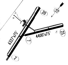
Runways
Runway Summary
| Runways: | 02/20 07/25 |
| Longest Runway: | 02/20 is 7615 ft (2321 m) long |
| Runways with an Instrument Approach: |
RTN Airport Runway Details
| Runway 02/20 | 7615 ft x 75 ft (2321 m x 23 m) | |
| Runway Length Source: | NGS as of 05/05/2015 | |
| Surface: | Asphalt - Excellent condition - No special surface treatment | |
| Runway Pavement Class: | 25 /F/D/X/T | |
| Runway Edge Lights: | Medium Intensity | |
Runway Weight Bearing Capacity (in thousands of pounds) |
||
| Single Wheel Landing Gear: | 18.0 | |
Runway 02 |
Runway 20 |
|
Elevation: |
6332.3 | 6348.6 |
Latitude: |
36-44-03.0786N | 36-45-05.3618N |
Longitude: |
104-30-40.4659W | 104-29-47.8859W |
|
Runway True Alignment: |
034 | 214 |
Glide Path Angle: |
3.0 degrees | 0.0 degrees |
Traffic Pattern: |
Left | Left |
Runway Markings Type: |
Nonprecision Instrument | Nonprecision Instrument |
Runway Markings Condition: |
Good | Good |
Visual Glide Slope Indicators: |
2-Light PAPI On Left Side Of Runway | |
Threshold Crossing Height: |
44 |
| Runway 07/25 | 4425 ft x 75 ft (1349 m x 23 m) | |
| Runway Length Source: | NGS as of 05/05/2015 | |
| Surface: | Asphalt - Excellent condition - No special surface treatment | |
| Runway Pavement Class: | 6 /F/D/X/T | |
| Runway Edge Lights: | Medium Intensity | |
Runway Weight Bearing Capacity (in thousands of pounds) |
||
| Single Wheel Landing Gear: | 12.0 | |
Runway 07 |
Runway 25 |
|
Elevation: |
6342.0 | 6309.7 |
Latitude: |
36-44-25.6096N | 36-44-34.9957N |
Longitude: |
104-30-19.0594W | 104-29-25.9594W |
|
Runway True Alignment: |
078 | 258 |
Glide Path Angle: |
0.0 degrees | 0.0 degrees |
Traffic Pattern: |
Left | Left |
Runway Markings Type: |
Basic | Nonprecision Instrument |
Runway Markings Condition: |
Good | Good |
Services
Airframe Repair: |
Minor |
Powerplant Repair: |
Minor |
Fuel Available: |
100LL |
Landing Fees: |
No |
Parking: |
Tiedowns available |
Other Services: |
Commuter airline |
Maps & Diagrams
RTN Sectional
Flight Planning
at skyvector.com
at skyvector.com