Location
Latitude: |
36-25-19.2010N (36.422) |
Longitude: |
105-17-23.6580W (-105.289905) |
Elevation: |
8379.5 feet MSL (2554 m MSL) |
Magnetic Variation: |
7.5 E (as of April 2024 from WMM2020 model) |
Time Zone: |
UTC -7.0 (Standard Time) UTC -6.0 (Daylight Savings Time) |
From City: |
01 N.M. N of Angel Fire, New Mexico |
Found On: |
Denver Chart |
FAA Region: |
ASW |
Contacts
Manager: |
Publicly owned: |
| SCOTT MATTHEWS 3570 HWY 434 ANGEL FIRE, NM 87710 (575) 377-3171 |
COLFAX COUNTY PO BOX 1498 RATON, NM 88740 575-445-9661 |
Operations
Airport Status: |
Operational |
Facility Use: |
Public |
Type: |
Airport |
Activation Date: |
09/1966 |
Control tower: |
No |
Attendance (Months/Days/Hours): |
Months/Days/Hours ALL/ALL/0800-1630 |
Boundary ARTCC: |
ZAB (Albuquerque) |
Responsible ARTCC: |
ZAB (Albuquerque) |
Lighting Schedule: |
SEE RMK |
Segmented Circle Indicator: |
Yes |
Traffic Pattern Altitude (MSL): |
9380 feet (2859 m) |
NOTAMs Facility: |
ABQ |
NOTAM-D Service: |
Yes |
Military Landing Rights: |
Yes |
Based Aircraft
| Single Engine: | 6 |
Annual Operations (as of 04/24/2022)
| Total Operations: | 6000 | |
| Air Taxi: | 200 | 3.3% |
| GA Local: | 1800 | 30.0% |
| GA Itinerant: | 3000 | 50.0% |
| Military Aircraft: | 1000 | 16.7% |
Communications
| CTAF: | 122.800 |
| Unicom: | 122.800 |
| AWOS-3: | 118.025 (575-377-0526) |
- APCH/DEP SVC PRVDD BY ALBUQUERQUE ARTCC ON FREQS 132.8/346.35 (RATON RCAG).
Fixed Based Operators (FBOs) & Fuel
(Click on a business for detail)
Please help us keep this information up to date. This is a FREE SERVICE just like everything else on Airport Guide! If you see that a business needs to be added, modified, or deleted please fill out our Update Form.
To add, modify, or delete a business click here.
Please help us keep this information up to date. This is a FREE SERVICE just like everything else on Airport Guide! If you see that a business needs to be added, modified, or deleted please fill out our Update Form.
Area Code: 505 |
| Business Name | Frequency | Phone | Fuel Grade |
|---|---|---|---|
| Ross Aviation
Update FBO info |
Unicom 122.8 | 377-3160 | 100LL, Jet A |
Flight Service Stations
| Primary | Alternate | |
| FSS on Field: | N | |
| FSS Name (ID): | Albuquerque(ABQ) | |
| Frequency: | ||
| Toll Free Phone: | 1-800-WX-BRIEF |
Instrument Procedures / Charts
FAA Terminal Procedures valid from 0901Z 03/21/24 to 0901Z 04/18/24.
There are various types of charts available for an airport. They are listed in the Page Type column. Here is a legend for those types:
APD - Airport Diagram
DP - Departure Procedure Charts
HOT - Hot Spots
IAP - Instrument Approach Procedure Charts
MIN - Minimums
STAR - Standard Terminal Arrival Charts
| Page Type | Page Name | Volume | Action Since Last Cycle |
|---|---|---|---|
| IAP | RNAV (GPS) RWY 17 | SW-1 | |
| MIN | TAKEOFF MINIMUMS | SW-1 | |
| ODP | ANEKE TWO (OBSTACLE) (RNAV) | SW-1 |
Terminal Procedures are only available for airports in several countries with more being added all the time. If you are looking for a specific country's charts, please send an email to support(at)airportguide.com stating the country name. This will be used to prioritize the implementation.
Navigation Aids (Navaids) near AXX
| Dist (NM) | ID | Morse Code | Name | Type | Freq | True Hdg | Mag Hdg |
|---|---|---|---|---|---|---|---|
| 20.6 | CIM | _ . _ . . . _ _ | Cimarron | VORTAC | 116.40 | 78 | 71 |
| 31.8 | TAS | _ . _ . . . | Taos | VORTAC | 115.80 | 290 | 282 |
| 46.5 | FTI | . . _ . _ . . | Fort Union | VORTAC | 117.30 | 170 | 163 |
| 61.1 | ALS | . _ . _ . . . . . | Alamosa | VORTAC | 113.90 | 335 | 327 |
| 64.9 | SAF | . . . . _ . . _ . | Santa Fe | VORTAC | 110.60 | 215 | 207 |
| 66.4 | SG | . . . _ _ . | Doman | NDB | 341 | 218 | 210 |
| 70.2 | TAD | _ . _ _ . . | Trinidad | NDB | 329 | 40 | 33 |
| 79.6 | ACH | . _ _ . _ . . . . . | Anton Chico | VORTAC | 117.80 | 171 | 164 |
| 86.9 | OTO | _ _ _ _ _ _ _ | Otto | VOR | 114.00 | 201 | 193 |
| 95.4 | TBE | _ _ . . . . | Tobe | VOR-DME | 114.05 | 57 | 50 |
Nearby Airports with Fuel
Notices to Airmen (NOTAMS)
Remarks
| A110-1 | ARPT LCTD IN MOUNTAIN VALLEY; RISING TERRAIN IN ALL DIRECTIONS. STRONG GUSTY CROSSWINDS POSSIBLE. HIGH DENSITY ALTITUDE PROBABLE. |
| A110-10 | FOR CD CTC ALBUQUERQUE ARTCC AT 505-856-4861. |
| A110-7 | 6-8 INCH DROP OFF AT THLD OF RWY 17. |
| A110-8 | AVOID OVERFLIGHT OF TAOS PUEBLO WORLD HERITGE SITE WEST OF ARPT. |
| A110-9 | COLD TEMPERATURE AIRPORT. ALTITUDE CORRECTION REQUIRED AT OR BELOW -30C. |
| A16 | ALTERNATE PHONE: 505-632-9353. |
| A70-FUEL-10 | 0LL 24 HR. SELF SERVE 100LL, JETA+ WITH MAJOR CREDIT CARD |
| A81-APT | ACTVT MIRL RY 17/35 & PSIL - CTAF. |
| A81-BCN | ACTVT ROTG BCN - CTAF. |
Runways
Runway Summary
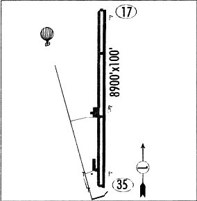
| Runways: | 17/35 |
| Longest Runway: | 17/35 is 8900 ft (2713 m) long |
| Runways with an Instrument Approach: |
AXX Airport Runway Details
| Runway 17/35 | 8900 ft x 100 ft (2713 m x 30 m) | |
| Surface: | Asphalt - Good condition - No special surface treatment | |
| Runway Pavement Class: | 37 /F/C/X/T | |
| Runway Edge Lights: | Medium Intensity | |
Runway Weight Bearing Capacity (in thousands of pounds) |
||
| Single Wheel Landing Gear: | 30.0 | |
| Dual Wheel Landing Gear: | 45.0 | |
Runway 17 |
Runway 35 |
|
Elevation: |
8322.3 | 8379.5 |
Latitude: |
36-26-03.1650N | 36-24-35.2360N |
Longitude: |
105-17-21.9940W | 105-17-25.3230W |
|
Runway True Alignment: |
182 | 002 |
Glide Path Angle: |
0.0 degrees | 0.0 degrees |
Traffic Pattern: |
Left | Left |
Runway Markings Type: |
Nonprecision Instrument | Basic |
Runway Markings Condition: |
Fair | Fair |
Object at End: |
GND | ROAD |
Object Height: |
118 | 8 |
Distance from End: |
2576 | 360 |
Object Centerline Offset: |
360 ft. right of centerline | 0 ft. left and right of centerline |
Visual Glide Slope Indicators: |
Pulsating/Steady Burning VASI On Left Side Of Runway | |
REIL: |
Yes | Yes |
Services
Airframe Repair: |
Minor |
Powerplant Repair: |
Minor |
Bottled Oxygen: |
None |
Bulk Oxygen: |
High Pressure |
Fuel Available: |
100LL, Jet A |
Landing Fees: |
No |
Parking: |
Hangars and tiedowns available |
Other Services: |
Plane washing |
Maps & Diagrams
AXX Sectional
Flight Planning
at skyvector.com
at skyvector.com