Location
Latitude: |
35-57-49.8000N (35.963833) |
Longitude: |
083-52-25.2000W (-83.873667) |
Elevation: |
833.2 feet MSL (254 m MSL) |
Magnetic Variation: |
6.1 W (as of May 2024 from WMM2020 model) |
Time Zone: |
UTC -5.0 (Standard Time) UTC -4.0 (Daylight Savings Time) |
From City: |
03 N.M. E of Knoxville, Tennessee |
Found On: |
Atlanta Chart |
FAA Region: |
ASO |
Contacts
Manager: |
Publicly owned: |
| ROB VOYLES 2701 SPENCE PLACE KNOXVILLE, TN 37920 (865) 342-3182 |
KNOXVILLE METRO ARPT AUTH PO BOX 15600 KNOXVILLE, TN 37901 865-342-3000 |
Operations
Airport Status: |
Operational |
Facility Use: |
Public |
Type: |
Airport |
Activation Date: |
11/1938 |
Control tower: |
No |
Attendance (Months/Days/Hours): |
Months/Days/Hours ALL/ALL/0700-2200 |
Boundary ARTCC: |
ZTL (Atlanta) |
Responsible ARTCC: |
ZTL (Atlanta) |
Lighting Schedule: |
SEE RMK |
Segmented Circle Indicator: |
Yes |
Traffic Pattern Altitude (MSL): |
1833 feet (559 m) |
NOTAMs Facility: |
BNA |
NOTAM-D Service: |
Yes |
International Airport of Entry: |
No |
Customs Landing Rights: |
No |
Military Landing Rights: |
Yes |
Civil/Military Joint Use: |
No |
Based Aircraft
| Single Engine: | 131 |
| Multi Engine: | 20 |
| GA Helicopters: | 8 |
| Gliders: | 2 |
Annual Operations (as of 07/28/2022)
| Total Operations: | 76700 | |
| Air Taxi: | 400 | 0.5% |
| GA Local: | 38500 | 50.2% |
| GA Itinerant: | 37500 | 48.9% |
| Military Aircraft: | 300 | 0.4% |
Communications
| CTAF: | 123.075 |
| Unicom: | 123.075 |
| Clearance Del.: | 121.7 121.7 121.7 |
| Approach: | KNOXVILLE |
| Departure: | KNOXVILLE |
| AWOS-3: | 125.375 (865-579-6151) |
Fixed Based Operators (FBOs) & Fuel
(Click on a business for detail)
Please help us keep this information up to date. This is a FREE SERVICE just like everything else on Airport Guide! If you see that a business needs to be added, modified, or deleted please fill out our Update Form.
To add, modify, or delete a business click here.
Please help us keep this information up to date. This is a FREE SERVICE just like everything else on Airport Guide! If you see that a business needs to be added, modified, or deleted please fill out our Update Form.
Area Code: 865 |
| Business Name | Frequency | Phone | Fuel Grade |
|---|---|---|---|
| Campbell Aero, Inc.
Update FBO info |
577-3287 | 100LL, Jet A |
Flight Service Stations
| Primary | Alternate | |
| FSS on Field: | N | |
| FSS Name (ID): | Nashville(BNA) | |
| Frequency: | ||
| Toll Free Phone: | 1-800-WX-BRIEF |
Instrument Procedures / Charts
FAA Terminal Procedures valid from 0901Z 03/21/24 to 0901Z 04/18/24.
There are various types of charts available for an airport. They are listed in the Page Type column. Here is a legend for those types:
APD - Airport Diagram
DP - Departure Procedure Charts
HOT - Hot Spots
IAP - Instrument Approach Procedure Charts
MIN - Minimums
STAR - Standard Terminal Arrival Charts
| Page Type | Page Name | Volume | Action Since Last Cycle |
|---|---|---|---|
| IAP | LOC RWY 26 | SE-1 | Changed |
| IAP | RNAV (GPS) RWY 26 | SE-1 | Changed |
| IAP | VOR-B | SE-1 | Changed |
| MIN | ALTERNATE MINIMUMS | SE-1 | |
| MIN | TAKEOFF MINIMUMS | SE-1 |
Terminal Procedures are only available for airports in several countries with more being added all the time. If you are looking for a specific country's charts, please send an email to support(at)airportguide.com stating the country name. This will be used to prioritize the implementation.
Navigation Aids (Navaids) near KDKX
| Dist (NM) | ID | Morse Code | Name | Type | Freq | True Hdg | Mag Hdg |
|---|---|---|---|---|---|---|---|
| 3.7 | VXV | . . . _ _ . . _ . . . _ | Volunteer | VORTAC | 116.40 | 196 | 202 |
| 10.7 | TYS | _ _ . _ _ . . . | Knoxville | VOT | 112.00 | 213 | 219 |
| 21.2 | JXT | . _ _ _ _ . . _ _ | Jefferson | NDB | 346 | 65 | 71 |
| 35.3 | MNV | _ _ _ . . . . _ | Madisonville | NDB | 361 | 224 | 230 |
| 41.3 | SOT | . . . _ _ _ _ | Snowbird | VORTAC | 108.80 | 104 | 110 |
| 45.2 | BPO | _ . . . . _ _ . _ _ _ | Piney Grove | NDB | 403 | 320 | 326 |
| 47.9 | MMI | _ _ _ _ . . | Mc Minn County | NDB | 242 | 224 | 230 |
| 48.8 | DYQ | _ . . _ . _ _ _ _ . _ | Dulaney | NDB | 263 | 77 | 83 |
| 54.8 | HCH | . . . . _ . _ . . . . . | Hinch Mountain | VOR-DME | 117.60 | 258 | 264 |
| 56.3 | RVN | . _ . . . . _ _ . | Rogersville | NDB | 329 | 58 | 64 |
| 59.1 | DTE | _ . . _ . | Mark Anton | NDB | 394 | 240 | 246 |
| 61.3 | HRS | . . . . . _ . . . . | Harris | VORTAC | 109.80 | 181 | 187 |
| 65.2 | LOZ | . _ . . _ _ _ _ _ . . | London | VOR-DME | 116.55 | 349 | 355 |
| 67.8 | IM | . . _ _ | Keans | NDB | 357 | 112 | 119 |
| 70.0 | HDI | . . . . _ . . . . | Hardwick | NDB | 369 | 226 | 232 |
| 71.6 | BO | _ . . . _ _ _ | Booie | NDB | 221 | 68 | 75 |
| 72.8 | LVT | . _ . . . . . _ _ | Livingston | VOR-DME | 114.35 | 301 | 307 |
| 73.2 | CDX | _ . _ . _ . . _ . . _ | Cumberland River | NDB | 388 | 328 | 334 |
| 78.8 | CQN | _ . _ . _ _ . _ _ . | Daisy | NDB | 341 | 233 | 239 |
| 80.0 | BRA | _ . . . . _ . . _ | Broad River | NDB | 379 | 120 | 127 |
Nearby Airports with Fuel
Notices to Airmen (NOTAMS)
Remarks
| A110-1 | GEESE ON & INVOF ARPT. |
| A110-6 | TFR OVR STADIUM 2.5 MI W; INFO & TIMES - 865-577-4461. |
| A110-7 | FOR CD CTC KNOXVILLE APCH AT 865-980-3034; IF UNA FOR CD CTC KNOXVILLE APCH AT 865-980-3033. |
| A30A-08 | CALM WIND RWY. |
| A30A-26 | NOISE SENSITIVE AREA 1 NM SW; DEP AVOID FLT OVR NBRHD. |
| A70-FUEL-10 | 0LL 100LL SELF SERV H24 WITH CREDIT CARD. |
| A81-APT | REIL RWY 08 & 26; MIRL RWY 08/26 & TWY LGTS OPR DUSK-DAWN & PRESET LOW INTST; INCR INTST & ACTVT REIL RWY 08 & 26; PAPI RWY 08 & 26; MIRL RWY 08/26 - 126.6. |
Runways
Runway Summary
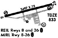
| Runways: | 08/26 |
| Longest Runway: | 08/26 is 3499 ft (1066 m) long |
| Runways with an Instrument Approach: | 26 |
KDKX Airport Runway Details
| Runway 08/26 | 3499 ft x 75 ft (1066 m x 23 m) | |
| Runway Length Source: | 3RD PARTY SURVEY as of 12/21/2016 | |
| Surface: | Asphalt - Good condition - No special surface treatment | |
| Runway Edge Lights: | Medium Intensity | |
Runway Weight Bearing Capacity (in thousands of pounds) |
||
| Single Wheel Landing Gear: | 22.0 | |
Runway 08 |
Runway 26 |
|
Elevation: |
833.0 | 830.7 |
Latitude: |
35-57-45.3300N | 35-57-54.1826N |
Longitude: |
083-52-45.7740W | 083-52-04.6324W |
|
Runway True Alignment: |
075 | 255 |
ILS Type: |
LOCALIZER | |
Glide Path Angle: |
3.8 degrees | 3.4 degrees |
Traffic Pattern: |
Left | Left |
Runway Markings Type: |
Basic | Nonprecision Instrument |
Runway Markings Condition: |
Good | Good |
Object at End: |
TREE | |
Object Height: |
49 | |
Distance from End: |
865 | |
Object Centerline Offset: |
153 ft. right of centerline | |
Visual Glide Slope Indicators: |
2-Light PAPI On Left Side Of Runway | 2-Light PAPI On Left Side Of Runway |
REIL: |
Yes | Yes |
Threshold Crossing Height: |
43 | 44 |
Services
Airframe Repair: |
Minor |
Powerplant Repair: |
Minor |
Fuel Available: |
100LL, Jet A+ |
Landing Fees: |
No |
Parking: |
Hangars and tiedowns available |
Maps & Diagrams
KDKX Sectional
Flight Planning
at skyvector.com
at skyvector.com