Location
Latitude: |
35-04-22.2760N (35.072854) |
Longitude: |
077-02-34.8710W (-77.04302) |
Elevation: |
17.9 feet MSL (5 m MSL) |
Magnetic Variation: |
10.2 W (as of April 2024 from WMM2020 model) |
Time Zone: |
UTC -5.0 (Standard Time) UTC -4.0 (Daylight Savings Time) |
From City: |
03 N.M. SE of New Bern, North Carolina |
Found On: |
Charlotte Chart |
FAA Region: |
ASO |
Contacts
Manager: |
Publicly owned: |
| ANDREW SHORTER 200 TERMINAL DRIVE NEW BERN, NC 28562-6455 252-638-8591 |
CRAVEN COUNTY PO BOX 3258 NEW BERN, NC 28560 252-638-8591 |
Operations
Airport Status: |
Operational |
Facility Use: |
Public |
Type: |
Airport |
Activation Date: |
07/1941 |
Control tower: |
Yes |
Attendance (Months/Days/Hours): |
Months/Days/Hours ALL/ALL/0500-2330 |
Boundary ARTCC: |
ZDC (Washington) |
Responsible ARTCC: |
ZDC (Washington) |
Lighting Schedule: |
SEE RMK |
Segmented Circle Indicator: |
No |
Traffic Pattern Altitude (MSL): |
1018 feet (310 m) |
NOTAMs Facility: |
EWN |
NOTAM-D Service: |
Yes |
International Airport of Entry: |
No |
Customs Landing Rights: |
No |
Military Landing Rights: |
Yes |
Civil/Military Joint Use: |
No |
Aircraft Rescue and Firefighting: |
Class I ARFF Index: A Air Carrier Service: Scheduled Certification Date: 05/1973 |
Based Aircraft
| Single Engine: | 80 |
| Multi Engine: | 5 |
| Jet Engine: | 3 |
| GA Helicopters: | 2 |
Annual Operations (as of 07/31/2023)
| Total Operations: | 59063 | |
| Commercial: | 2501 | 4.2% |
| Air Taxi: | 3424 | 5.8% |
| GA Local: | 31983 | 54.2% |
| GA Itinerant: | 18906 | 32.0% |
| Military Aircraft: | 2249 | 3.8% |
Communications
| CTAF: | 124.250 |
| Tower: | NEW BERN 124.25 Hrs: 0600-2200 |
| Clearance Del.: | 121.7 |
| Ground: | 121.7 |
| Approach: | CHERRY POINT 119.35 119.35 119.35 119.35 |
| Departure: | CHERRY POINT 119.35 119.35 119.35 119.35 |
| ASOS: | 118.525 (252-514-2086) |
| EMERG: | 121.5 |
- APCH/DEP SVC PRVDD BY NAS CHERRY POINT APCH CNTL ON FREQ 120.525.
- RVA INC.
Fixed Based Operators (FBOs) & Fuel
(Click on a business for detail)
Please help us keep this information up to date. This is a FREE SERVICE just like everything else on Airport Guide! If you see that a business needs to be added, modified, or deleted please fill out our Update Form.
To add, modify, or delete a business click here.
Please help us keep this information up to date. This is a FREE SERVICE just like everything else on Airport Guide! If you see that a business needs to be added, modified, or deleted please fill out our Update Form.
Area Code: 252 |
| Business Name | Frequency | Phone | Fuel Grade |
|---|---|---|---|
| Carolina Air Services, Inc.
Update FBO info |
633-1400, -6151 | 100LL, Jet A |
Flight Service Stations
| Primary | Alternate | |
| FSS on Field: | N | |
| FSS Name (ID): | Raleigh(RDU) | |
| Frequency: | ||
| Toll Free Phone: | 1-800-WX-BRIEF |
Instrument Procedures / Charts
FAA Terminal Procedures valid from 0901Z 03/21/24 to 0901Z 04/18/24.
There are various types of charts available for an airport. They are listed in the Page Type column. Here is a legend for those types:
APD - Airport Diagram
DP - Departure Procedure Charts
HOT - Hot Spots
IAP - Instrument Approach Procedure Charts
MIN - Minimums
STAR - Standard Terminal Arrival Charts
| Page Type | Page Name | Volume | Action Since Last Cycle |
|---|---|---|---|
| APD | AIRPORT DIAGRAM | SE-2 | Changed |
| IAP | ILS OR LOC RWY 04 | SE-2 | Changed |
| IAP | RNAV (GPS) RWY 04 | SE-2 | Changed |
| IAP | RNAV (GPS) RWY 22 | SE-2 | Changed |
| IAP | VOR RWY 22 | SE-2 | Changed |
| MIN | ALTERNATE MINIMUMS | SE-2 | |
| MIN | TAKEOFF MINIMUMS | SE-2 |
Terminal Procedures are only available for airports in several countries with more being added all the time. If you are looking for a specific country's charts, please send an email to support(at)airportguide.com stating the country name. This will be used to prioritize the implementation.
Navigation Aids (Navaids) near EWN
| Dist (NM) | ID | Morse Code | Name | Type | Freq | True Hdg | Mag Hdg |
|---|---|---|---|---|---|---|---|
| 0.1 | EWN | . . _ _ _ . | New Bern | VOR-DME | 113.60 | 278 | 288 |
| 3.6 | EW | . . _ _ | Katfi | NDB | 362 | 210 | 220 |
| 13.2 | NKT | _ . _ . _ _ | Cherry Point | TACAN | 112.80 | 141 | 151 |
| 26.4 | RNW | . _ . _ . . _ _ | Chocowinity | NDB | 388 | 353 | 363 |
| 27.8 | MRH | _ _ . _ . . . . . | Morehead | NDB | 269 | 137 | 147 |
| 29.4 | NCA | _ . _ . _ . . _ | New River | TACAN | 115.40 | 221 | 231 |
| 30.9 | ISO | . . . . . _ _ _ | Kinston | VORTAC | 117.50 | 305 | 315 |
| 33.7 | IS | . . . . . | Stals | NDB | 276 | 287 | 297 |
| 36.4 | DIW | _ . . . . . _ _ | Dixon | NDB | 198 | 213 | 223 |
| 37.9 | OA | _ _ _ . _ | Ellas | NDB | 261 | 239 | 249 |
| 37.9 | PGV | . _ _ . _ _ . . . . _ | Belvoir | FAN MARKER | 334 | 344 | |
| 41.3 | AQE | . _ _ _ . _ . | Alwood | NDB | 230 | 337 | 347 |
| 43.0 | DKA | _ . . _ . _ . _ | Kenan | NDB | 332 | 270 | 280 |
| 47.6 | MCZ | _ _ _ . _ . _ _ . . | Williamston | NDB | 336 | 352 | 362 |
| 48.2 | GSB | _ _ . . . . _ . . . | Seymour Johnson | TACAN | 116.50 | 289 | 299 |
| 51.9 | OUC | _ _ _ . . _ _ . _ . | Pamlico/Dcmsnd | NDB-DME | 404 | 86 | 96 |
| 57.3 | ETC | . _ _ . _ . | Tarboro | NDB | 257 | 334 | 344 |
| 58.2 | GM | _ _ . _ _ | Wilze | NDB | 205 | 220 | 230 |
| 59.6 | ILM | . . . _ . . _ _ | Wilmington | VORTAC | 117.00 | 223 | 233 |
| 61.7 | EDE | . _ . . . | Edenton | NDB | 265 | 22 | 32 |
Nearby Airports with Fuel
Notices to Airmen (NOTAMS)
Remarks
| A110-1 | MIL TACTICAL JET ACFT; STRAIGHT IN, FULL STOP LDGS ONLY; RWY 14/32 FOR EUO. |
| A110-2 | RWY 14/32 AND ASSOCIATED TWYS NOT AVBL FOR SCHEDULED ACR OPNS WITH MORE THAN 9 PSGR SEATS OR UNSCHEDULED ACR AT LEAST 31 PSGR SEATS. |
| A26 | CLSD TO UNSKED ACR OPNS WITH MORE THAN 30 PSGR SEATS EXCP 24 HR PPR CALL AMGR 252-638-8591. |
| A81-APT | ACTVT REIL RWY 04, 22, 14 & 32; HIRL 04/22, MIRL 14/32 - CTAF. PAPI RWY 04, 22, 14 & 32 OPER CONTINUOUSLY. |
| E111 | ESTAB PRIOR 1958. |
| E60-22 | ARRESTING GEAR/SYSTEM: ENGINEERED MATERIALS ARRESTING SYSTEM (EMAS) 279.42 FT IN LENGTH BY 162 FT IN WIDTH LOCATED AT THE DEPARTURE END OF RWY 22. |
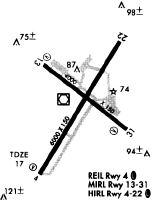
Runways
Runway Summary
| Runways: | 04/22 14/32 |
| Longest Runway: | 04/22 is 6452 ft (1967 m) long |
| Runways with an Instrument Approach: | 04 |
EWN Airport Runway Details
| Runway 04/22 | 6452 ft x 150 ft (1967 m x 46 m) | |
| Runway Length Source: | 3RD PARTY SURVEY as of 10/09/2019 | |
| Surface: | Asphalt - Good condition - Saw-cut or plastic grooved | |
| Runway Pavement Class: | 31 /F/B/X/T | |
| Runway Edge Lights: | High Intensity | |
Runway Weight Bearing Capacity (in thousands of pounds) |
||
| Single Wheel Landing Gear: | 80.0 | |
| Dual Wheel Landing Gear: | 123.0 | |
Runway 04 |
Runway 22 |
|
Elevation: |
13.4 | 14.5 |
Latitude: |
35-03-53.0402N | 35-04-47.9059N |
Longitude: |
077-02-55.6403W | 077-02-15.9998W |
|
Runway True Alignment: |
031 | 211 |
ILS Type: |
ILS | |
Glide Path Angle: |
3.0 degrees | 3.0 degrees |
Traffic Pattern: |
Left | Left |
Runway Markings Type: |
Precision Instrument | Precision Instrument |
Runway Markings Condition: |
Good | Good |
Arresting Device: |
EMAS | |
Object at End: |
TREES | |
Object Height: |
68 | |
Distance from End: |
2543 | |
Object Centerline Offset: |
558 ft. left of centerline | |
Visual Glide Slope Indicators: |
4-Light PAPI On Left Side Of Runway | 4-Light PAPI On Left Side Of Runway |
REIL: |
Yes | Yes |
Threshold Crossing Height: |
50 | 31 |
Threshold Elevation: |
13.6 | |
Displaced Threshold: |
299 | |
Threshold Latitude: |
35-03-55.5785N | |
Threshold Longitude: |
077-02-53.8044W | |
Declared Distances |
||
Take Off Run Avbl. (TORA): |
6453 | 6453 |
Take Off Distance Avbl. (TODA): |
6453 | 6453 |
Actual Stop Dist. Avbl. (ASDA): |
6053 | 6153 |
Landing Dist. Avbl. (LDA): |
5753 | 6153 |
| Runway 14/32 | 4001 ft x 150 ft (1220 m x 46 m) | |
| Runway Length Source: | 3RD PARTY SURVEY as of 10/09/2019 | |
| Surface: | Asphalt - Good condition - No special surface treatment | |
| Runway Pavement Class: | 14 /F/C/X/T | |
| Runway Edge Lights: | Medium Intensity | |
Runway Weight Bearing Capacity (in thousands of pounds) |
||
| Single Wheel Landing Gear: | 28.0 | |
| Dual Wheel Landing Gear: | 45.0 | |
Runway 14 |
Runway 32 |
|
Elevation: |
11.6 | 17.6 |
Latitude: |
35-04-37.3432N | 35-04-13.0197N |
Longitude: |
077-02-52.3182W | 077-02-14.3570W |
|
Runway True Alignment: |
128 | 308 |
Glide Path Angle: |
4.0 degrees | 3.0 degrees |
Traffic Pattern: |
Left | Left |
Runway Markings Type: |
Nonprecision Instrument | Nonprecision Instrument |
Runway Markings Condition: |
Good | Good |
Object at End: |
TREES | TREE |
Object Height: |
28 | 26 |
Distance from End: |
1000 | 862 |
Object Centerline Offset: |
558 ft. left of centerline | |
Visual Glide Slope Indicators: |
2-Light PAPI On Left Side Of Runway | 2-Light PAPI On Left Side Of Runway |
REIL: |
Yes | Yes |
Threshold Crossing Height: |
39 | 29 |
Services
Airframe Repair: |
Major |
Powerplant Repair: |
Major |
Bottled Oxygen: |
None |
Bulk Oxygen: |
None |
Fuel Available: |
100LL, Jet A-1+ |
Landing Fees: |
No |
Parking: |
Hangars and tiedowns available |
Maps & Diagrams

EWN Sectional
Flight Planning
at skyvector.com
at skyvector.com