
Location
Latitude: |
48-38-53.0081N (48.648058) |
Longitude: |
123-25-38.7944W (-123.427443) |
Elevation: |
64.0 feet MSL (20 m MSL) |
Magnetic Variation: |
15.4 E (as of December 2025 from WMM2020 model) |
Time Zone: |
UTC -8.0 (Standard Time) UTC -7.0 (Daylight Savings Time) |
From City: |
12 N.M. NNW of Victoria, British Columbia |
Contacts
Manager: |
Privately owned: |
| VICTORIA INTL ARPT AUTHORITY 250-953-7500 |
Operations
Airport Status: |
Operational |
Facility Use: |
Public |
Type: |
Airport |
Activation Date: |
04/2005 |
Control tower: |
Yes |
Boundary ARTCC: |
ZVR (Vancouver) |
Responsible ARTCC: |
ZVR (Vancouver) |
Traffic Pattern Altitude (MSL): |
1064 feet (324 m) |
NOTAMs Facility: |
CYYJ |
International Airport of Entry: |
No |
Based Aircraft
Annual Operations (as of )
Communications
| Tower: | VICTORIAHrs: 1400-0800Z++ |
| Ground: | 121.9 |
| ATIS: | 118.8 |
Fixed Based Operators (FBOs) & Fuel
(Click on a business for detail)
Please help us keep this information up to date. This is a FREE SERVICE just like everything else on Airport Guide!
Please help us keep this information up to date. This is a FREE SERVICE just like everything else on Airport Guide!
| Business Name | Frequency | Phone | Fuel Grade |
|---|---|---|---|
| YYJ FBO Services LTD. / Shell Aerocentre
Website |
122.85 | (250) 655-8833 | Jet A-1 |
|
|
 Shell |
Jet A-1 - 1.770 CAD per litre on 05/07/2022 | Trucks |
|
|
Shell |
Jet A-1 - 1.780 CAD per litre on 9/4/2018 | Trucks with FSII |
|
|
Shell |
100LL - 2.028 CAD per litre on 05/07/2022 | Trucks |
Flight Service Stations
| Primary | Alternate | |
| FSS on Field: | ||
| FSS Name (ID): | Kamloops FIC(YKA) | |
| Frequency: | ||
| Toll Free Phone: |
Instrument Procedures / Charts
Terminal Procedures are only available for airports in several countries with more being added all the time. If you are looking for a specific country's charts, please send an email to support(at)airportguide.com stating the country name. This will be used to prioritize the implementation.
Navigation Aids (Navaids) near YYJ
| Dist (NM) | ID | Morse Code | Name | Type | Freq | True Hdg | Mag Hdg |
|---|---|---|---|---|---|---|---|
| 1.1 | YJ | _ . _ _ . _ _ _ | Victoria | NDB | 200 | 101 | 86 |
| 4.5 | MB | Mill Bay | NDB | 293 | 288 | 273 | |
| 5.2 | YYJ | _ . _ _ _ . _ _ . _ _ _ | Victoria | VOR-DME | 113.70 | 334 | 319 |
| 14.6 | AP | . _ . _ _ . | Active Pass | NDB | 378 | 21 | 6 |
| 18.0 | FHR | . . _ . . . . . . _ . | Friday Harbor | NDB | 284 | 116 | 101 |
| 22.5 | OPZ | _ _ _ . _ _ . _ _ . . | Lopez Island | NDB | 356 | 116 | 101 |
| 28.0 | YVR | Vancouver | VORTAC | 115.90 | 23 | 8 | |
| 28.0 | YVR | _ . _ _ . . . _ . _ . | Vancouver | VOR-DME | 115.90 | 22 | 7 |
| 30.2 | 1CD | Nanaimo | DME | 111.45 | 324 | 309 | |
| 30.5 | NOW | _ . _ _ _ . _ _ | Ediz Hook | NDB | 338 | 178 | 163 |
| 31.4 | CL | _ . _ . . _ . . | Elwha | NDB | 515 | 198 | 183 |
| 33.6 | IVR | Vancouver | DME | 109.50 | 15 | 360 | |
| 33.6 | ZVR | Sea Island | NDB | 368 | 14 | 359 | |
| 33.7 | YCD | _ . _ _ _ . _ . _ . . | Nanaimo | NDB | 251 | 328 | 313 |
| 34.1 | IMK | Vancouver | DME | 111.10 | 15 | 360 | |
| 34.2 | WC | . _ _ _ . _ . | White Rock | NDB | 332 | 51 | 36 |
| 34.7 | VR | Vancouver | NDB | 266 | 24 | 9 | |
| 34.8 | IRD | Vancouver | DME | 111.90 | 17 | 2 | |
| 35.2 | NUW | _ . . . _ . _ _ | Whidbey Island | TACAN | 113.80 | 119 | 104 |
| 37.0 | CVV | _ . _ . . . . _ . . . _ | Penn Cove | VOR-DME | 117.20 | 130 | 115 |
Nearby Airports with Fuel
Notices to Airmen (NOTAMS)
Remarks
No remarks for this landing facility
Runways
Runway Summary
| Runways: | 03/21 09/27 13/31 |
| Longest Runway: | 09/27 is 6998 ft (2133 m) long |
| Runways with an Instrument Approach: |
YYJ Airport Runway Details
| Runway 03/21 | 5026 ft x 200 ft (1532 m x 61 m) | |
| Runway Length Source: | OWNER as of 02/09/2012 | |
| Surface: | Asphalt - No special surface treatment | |
| Runway Edge Lights: | Medium Intensity | |
Runway 03 |
Runway 21 |
|
Elevation: |
46.0 | 54.0 |
Latitude: |
48-38-32.6600N | 48-39-08.2600N |
Longitude: |
123-26-07.4400W | 123-25-15.3200W |
|
Runway True Alignment: |
044 | 224 |
Glide Path Angle: |
0.0 degrees | 0.0 degrees |
REIL: |
Yes | Yes |
| Runway 09/27 | 6998 ft x 200 ft (2133 m x 61 m) | |
| Runway Length Source: | OWNER as of 02/09/2012 | |
| Surface: | Asphalt - No special surface treatment | |
| Runway Edge Lights: | High Intensity | |
Runway 09 |
Runway 27 |
|
Elevation: |
53.0 | 56.0 |
Latitude: |
48-39-06.7200N | 48-38-47.6200N |
Longitude: |
123-26-22.8100W | 123-24-42.6600W |
|
Runway True Alignment: |
106 | 286 |
Glide Path Angle: |
0.0 degrees | 0.0 degrees |
Approach Light System: |
Omnidirectional Approach Lighting System | Simplified Short Approach Lighting System With Runway Alignment Indicator Lights |
REIL: |
Yes | Yes |
| Runway 13/31 | 5001 ft x 200 ft (1524 m x 61 m) | |
| Runway Length Source: | OWNER as of 02/09/2012 | |
| Surface: | Asphalt - No special surface treatment | |
| Runway Edge Lights: | Medium Intensity | |
Runway 13 |
Runway 31 |
|
Elevation: |
58.0 | 44.0 |
Latitude: |
48-39-11.5500N | 48-38-27.9400N |
Longitude: |
123-26-02.0900W | 123-25-27.2600W |
|
Runway True Alignment: |
152 | 332 |
Glide Path Angle: |
0.0 degrees | 0.0 degrees |
Approach Light System: |
Omnidirectional Approach Lighting System | |
REIL: |
Yes | Yes |
Services
Airframe Repair: |
Major |
Powerplant Repair: |
Major |
Bottled Oxygen: |
High Pressure / Low Pressure |
Bulk Oxygen: |
High Pressure / Low Pressure |
Fuel Available: |
100LL, Jet A, Jet A+ |
Landing Fees: |
No |
Parking: |
Tiedowns available |
Ratings and Reviews
Write a review for Victoria International Airport
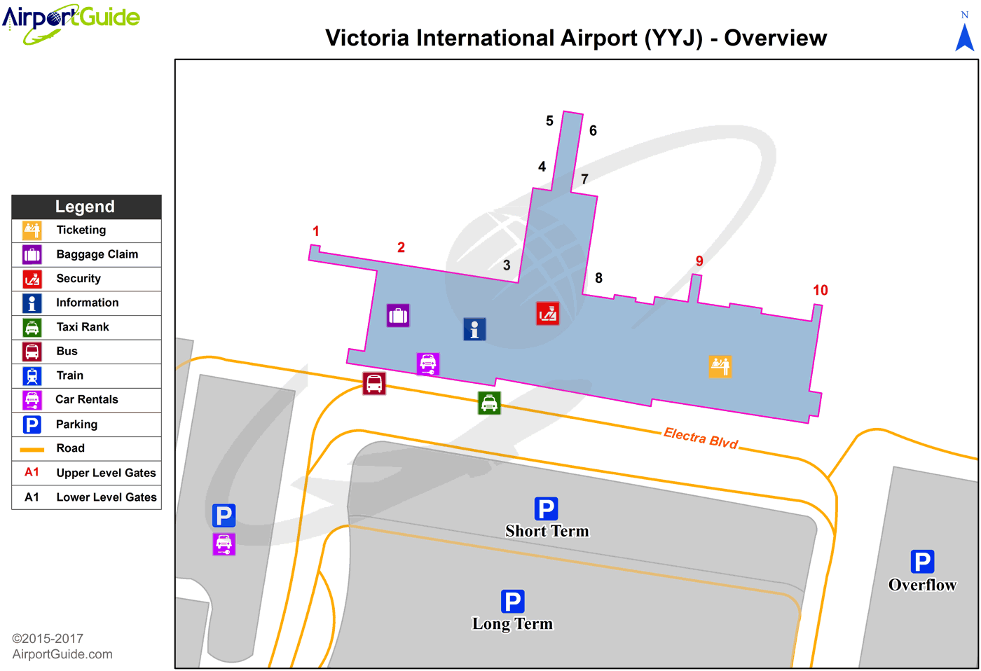
Maps & Diagrams
YYJ Sectional
Flight Planning
at skyvector.com
at skyvector.com