
Location
Latitude: |
39-52-19.5020N (39.872084) |
Longitude: |
075-14-26.3870W (-75.240663) |
Elevation: |
35.9 feet MSL (11 m MSL) |
Magnetic Variation: |
11.9 W (as of April 2024 from WMM2020 model) |
Time Zone: |
UTC -5.0 (Standard Time) UTC -4.0 (Daylight Savings Time) |
From City: |
05 N.M. SW of Philadelphia, Pennsylvania |
Found On: |
Washington Chart |
FAA Region: |
AEA |
Contacts
Manager: |
Publicly owned: |
| ATIF SAEED DIV OF AVIATION TERMINAL E PHILADELPHIA, PA 19153 215-937-6914 |
CITY OF PHILADELPHIA DIV OF AVIATION TERMINAL E PHILADELPHIA, PA 19153 215-937-6800 |
Operations
Airport Status: |
Operational |
Facility Use: |
Public |
Type: |
Airport |
Activation Date: |
10/1940 |
Control tower: |
Yes |
Attendance (Months/Days/Hours): |
Months/Days/Hours ALL/ALL/ALL |
Boundary ARTCC: |
ZDC (Washington) |
Responsible ARTCC: |
ZNY (New York) |
Segmented Circle Indicator: |
No |
Traffic Pattern Altitude (MSL): |
1036 feet (316 m) |
NOTAMs Facility: |
PHL |
NOTAM-D Service: |
Yes |
International Airport of Entry: |
No |
Customs Landing Rights: |
Yes |
Military Landing Rights: |
Yes |
Civil/Military Joint Use: |
No |
Aircraft Rescue and Firefighting: |
Class I ARFF Index: E Air Carrier Service: Scheduled Certification Date: 05/1973 |
Based Aircraft
| Single Engine: | 2 |
| Multi Engine: | 1 |
| Jet Engine: | 21 |
Annual Operations (as of 12/31/2022)
| Total Operations: | 284141 | |
| Commercial: | 215574 | 75.9% |
| Air Taxi: | 53509 | 18.8% |
| GA Itinerant: | 14468 | 5.1% |
| Military Aircraft: | 590 | 0.2% |
Communications
| Unicom: | 122.950 |
| Tower: | PHILADELPHIAHrs: 24 |
| Approach: | PHILADELPHIA Hrs: 24 |
| Departure: | PHILADELPHIA Hrs: 24 |
| ATIS: | Hrs: 24 |
| ASOS: | 133.4 (215-492-9617) |
| CLASS B: | 118.35 ;SW 6000 FT & BLW |
| CLASS B: | 124.35 ;W RWY 09 ACTIVE 8500-10000 FT |
| CLASS B: | 133.875 ;SOUTHEAST RWY 27 5500-7500 |
| CLASS B: | 317.55 ;6000-8000 FT |
| CLASS B: | 319.15 ;WEST RWY 09 ACTIVE 8500-10000 FT |
| CLASS B: | 124.35 ;W RWY 27 ACTIVE 10000 FT & BLW |
| CLASS B: | 128.4 ;NORTH 6500-7500 |
| CEDAR LAKE STAR: | 133.875 |
| CLASS B: | 269.25 ;SE RWY 09 ACTIVE 10000 FT & BLW |
| CLASS B: | 273.575 ;N NE 6500-7500 |
| CLASS B: | 317.55 ;RWY 27, 5500-7500 FT |
| PRM: | 123.6 ;RWY 26 |
| CLASS B: | 128.4 ;WEST RWY 09 ACTIVE 8000 FT & BLW |
| JIIMS STAR: | 133.875 |
| CLASS B: | 269.25 ;SE RWY 27 ACTIVE 8500-10000 FT |
| CLASS B: | 273.575 ;W RWY 09 ACTIVE 8000 FT & BLW |
| CLASS B: | 317.55 ;SE-SW 5000 FT & BLW |
| PHL ONE DP: | 319.15 |
| PHL ONE DP: | 124.35 |
| BUNTS STAR: | 128.4 |
| PAATS STAR: | 133.875 |
| CLASS B: | 269.25 ;SOUTH/SOUTHWEST RWY 27 8500-10000 FT |
| SLATT STAR: | 273.575 |
| CEDAR LAKE STAR: | 317.55 |
| CLASS B: | 323.1 ;SW 6000 FT & BLW |
| CLASS B: | 119.75 ;SE RWY 09 ACTIVE 10000 FT & BLW |
| CLASS B: | 123.8 ;NE 6500 FT & BLW |
| SLATT STAR: | 128.4 |
| JIIMS STAR: | 317.55 |
| CLASS B: | 119.75 ;SE RWY 27 ACTIVE 8500-10000 FT |
| 5500 & BLO: | 123.8 ;NORTH |
| SPUDS STAR: | 128.4 |
| CLASS B: | 272.575 ;NORTH 6500-7500 |
| CLASS B: | 291.7 ;NE RWY 27 ACTIVE 5000 FT & BLW |
| PAATS STAR: | 317.55 |
| CLASS B: | 119.75 ;SOUTH/SOUTHWEST RWY 27 8500-10000 FT |
| CLASS B: | 126.85 ;5500 FT & BLW |
| EMERG: | 243.0 |
| CLASS B: | 272.575 ;WEST RWY 09 ACTIVE 8000 FT & BLW |
| 5500 & BLO: | 291.7 ;NORTH |
| PRM: | 120.425 ;RWY 27L |
| CLASS B: | 124.35 ;NE 7000-10000 FT |
| BUNTS STAR: | 272.575 |
| CLASS B: | 319.15 ;NE 7000-10000 FT |
| EMERG: | 121.5 |
| CLASS B: | 124.35 ;NW 8000-10000 FT |
| CLASS B: | 127.35 ;SE-SW 5000 FT & BLW |
| CLASS B: | 133.875 ;6000-8000 FT |
| CLASS B: | 263.125 ;5500 FT & BLW |
| SPUDS STAR: | 272.575 |
| CLASS B: | 319.15 ;NW 8000-10000 FT |
- CLASS B: PILOTS CAN EXPECT TO EXIT AND RE-ENTER THE PHL CLASS B AIRSPACE DURING MODERATE TO HEAVY ARRIVAL PERIODS.
Fixed Based Operators (FBOs) & Fuel
(Click on a business for detail)
Please help us keep this information up to date. This is a FREE SERVICE just like everything else on Airport Guide! If you see that a business needs to be added, modified, or deleted please fill out our Update Form.
To add, modify, or delete a business click here.
Please help us keep this information up to date. This is a FREE SERVICE just like everything else on Airport Guide! If you see that a business needs to be added, modified, or deleted please fill out our Update Form.
Area Code: 215 |
| Business Name | Frequency | Phone | Fuel Grade |
|---|---|---|---|
| Atlantic Aviation
Update FBO info |
Unicom 122.95 | 492-2970 | 100LL, Jet A |
Flight Service Stations
| Primary | Alternate | |
| FSS on Field: | N | |
| FSS Name (ID): | Williamsport(IPT) | |
| Frequency: | ||
| Toll Free Phone: | 1-800-WX-BRIEF |
Instrument Procedures / Charts
FAA Terminal Procedures valid from 0901Z 03/21/24 to 0901Z 04/18/24.
There are various types of charts available for an airport. They are listed in the Page Type column. Here is a legend for those types:
APD - Airport Diagram
DP - Departure Procedure Charts
HOT - Hot Spots
IAP - Instrument Approach Procedure Charts
MIN - Minimums
STAR - Standard Terminal Arrival Charts
Terminal Procedures are only available for airports in several countries with more being added all the time. If you are looking for a specific country's charts, please send an email to support(at)airportguide.com stating the country name. This will be used to prioritize the implementation.
Navigation Aids (Navaids) near PHL
| Dist (NM) | ID | Morse Code | Name | Type | Freq | True Hdg | Mag Hdg |
|---|---|---|---|---|---|---|---|
| 0.5 | PHL | . _ _ . . . . . . _ . . | Philadelphia | VOT | 109.80 | 141 | 153 |
| 14.4 | OOD | _ _ _ _ _ _ _ . . | Woodstown | VORTAC | 112.80 | 191 | 203 |
| 15.4 | ING | . . _ . _ _ . | Ambler | NDB | 275 | 352 | 364 |
| 16.5 | PNE | . _ _ . _ . . | North Philadelphia | VOR | 112.00 | 40 | 52 |
| 20.0 | MXE | _ _ _ . . _ . | Modena | VORTAC | 113.20 | 278 | 290 |
| 20.5 | DQO | _ . . _ _ . _ _ _ _ | Dupont | VORTAC | 114.00 | 235 | 247 |
| 23.7 | VCN | . . . _ _ . _ . _ . | Cedar Lake | VOR-DME | 115.20 | 147 | 159 |
| 24.5 | IL | . . . _ . . | Hadin | NDB | 248 | 224 | 236 |
| 25.6 | PTW | . _ _ . _ . _ _ | Pottstown | VORTAC | 116.50 | 325 | 337 |
| 27.5 | ARD | . _ . _ . _ . . | Yardley | VOR-DME | 108.20 | 33 | 45 |
| 27.7 | RNB | . _ . _ . _ . . . | Rainbow | NDB | 363 | 169 | 181 |
| 30.8 | GXU | _ _ . _ . . _ . . _ | Mc Guire | VORTAC | 110.60 | 74 | 86 |
| 33.3 | UKT | . . _ _ . _ _ | Quakertown | NDB | 208 | 355 | 367 |
| 37.4 | CYN | _ . _ . _ . _ _ _ . | Coyle | VORTAC | 113.40 | 94 | 106 |
| 39.6 | ACY | . _ _ . _ . _ . _ _ | Atlantic City | VORTAC | 108.60 | 128 | 140 |
| 39.6 | RBV | . _ . _ . . . . . . _ | Robbinsville | VORTAC | 113.80 | 59 | 71 |
| 40.5 | ENO | . _ . _ _ _ | Smyrna | VORTAC | 111.40 | 198 | 210 |
| 42.0 | NEL | _ . . . _ . . | Lakehurst | TACAN | 111.80 | 76 | 88 |
| 42.9 | NEL | _ . . . _ . . | Lakehurst | NDB | 396 | 75 | 87 |
| 44.8 | APG | . _ . _ _ . _ _ . | Aberdeen | NDB | 349 | 243 | 255 |
Nearby Airports with Fuel
Notices to Airmen (NOTAMS)
Remarks
| A110-1 | BIRDS ON & INVOF ARPT. |
| A110-10 | TWY J BTN TWYS K3 AND Q RESTRICTED TO ACFT WITH WINGSPANS 171 FT AND LESS. |
| A110-12 | ONLY NOSE-IN PRKG PERMITTED ON NORTH REMOTE APNS. PPR FM ARPT OPS FOR ALL ACFT PRKG ON REMOTE APNS; CTC 215-937-6914/6800. |
| A110-13 | POSSIBLE UNMARKED SHIP OBSTRUCTION TRANSITING EAST OR WESTBOUND ALONG THE DELAWARE RIVER REACHING HEIGHTS OF 189' - BE ALERT WHEN APPROACHING PHL RUNWAY 35 AND WHENEVER CIRCLING OR VISUALLY APPROACHING ALL OTHER RUNWAYS. |
| A110-15 | ASDE-X IN USE. OPERATE TRANSPONDERS WITH ALTITUDE REPORTING MODE AND ADS-B (IF EQUIPPED) ENABLED ON ALL AIRPORT SURFACES. |
| A110-2 | RYS 27L, 27R & 35 SHIP CHNL (DELAWARE RIVER) MAX HEIGHT OF SHIPS 189 FT. RY 26 SHIP CHNL (SCHUYLKILL) MAX HEIGHT OF SHIPS 149 FT. |
| A110-3 | ARPT IS LCTD IN A NOISE SENSITIVE AREA. AIRPORT NOISE ABATEMENT TAKEOFF PROCEDURES ARE TO BE USED. |
| A110-5 | TCAS EQUIPPED ACFT-TCAS ALERT MAY BE CAUSED BY TRANSPONDER EQUIPPED SHIPS LCTD PHL NAVAL BASE 3 NM E. |
| A110-6 | UNLGTD STACK 288 FT MSL (271 FT AGL) 2.3 NM SW OF ARPT. |
| A110-7 | RY 09R ROLLOUT RVR USED FOR RY 09L MIDPOINT RVR. |
| A110-8 | ALL ENGINE RUNUPS REQUIRE PPR FM DUTY OPNS OFFICER AT 937-6914/6800; RUNUPS 20 MIN MAXIMUM. |
| A110-9 | ALL ACFT TRAVELING ON TWY J MUST USE MINIMUM POWER WHEN TURNING SOUTH DUE TO JETBLAST CONCERNS. |
| A30-08/26 | LND RY 26 TKOF RWY 08. |
| A43-26 | RY 26 PAPI UNUSBL BYD 8 DEGS RIGHT OF CNTRLN. |
| A63-27R | RWY 27R LDA 9500 FT AVBL O/R TO ATC. |
Runways
Runway Summary
| Runways: | 08/26 09L/27R 09R/27L 17/35 |
| Longest Runway: | 09R/27L is 12000 ft (3658 m) long |
| Runways with an Instrument Approach: | 26, 09L, 27R, 09R, 27L, 17 |
PHL Airport Runway Details
| Runway 08/26 | 5001 ft x 150 ft (1524 m x 46 m) | |
| Runway Length Source: | 3RD PARTY SURVEY as of 11/09/2017 | |
| Surface: | Asphalt - Good condition - Saw-cut or plastic grooved | |
| Runway Pavement Class: | 27 /F/A/X/T | |
| Runway Edge Lights: | High Intensity | |
Runway Weight Bearing Capacity (in thousands of pounds) |
||
| Dual Wheel Landing Gear: | 145.0 | |
Runway 08 |
Runway 26 |
|
Elevation: |
9.3 | 35.9 |
Latitude: |
39-52-42.0147N | 39-52-54.3825N |
Longitude: |
075-13-48.0500W | 075-12-45.9478W |
|
Runway True Alignment: |
075 | 256 |
ILS Type: |
ILS/DME | |
Glide Path Angle: |
0.0 degrees | 3.1 degrees |
Runway Markings Type: |
Basic | Precision Instrument |
Runway Markings Condition: |
Good | Good |
Object at End: |
TREE | |
Object Height: |
27 | |
Distance from End: |
679 | |
Object Centerline Offset: |
331 ft. left of centerline | |
Visual Glide Slope Indicators: |
4-Light PAPI On Right Side Of Runway | |
Runway Visual Range (RVR): |
Touchdown, Rollout | Touchdown, Rollout |
Approach Light System: |
1,400 Foot Medium Intensity Approach Lighting System With Runway Alignment Indicator Lights | |
Centerline Lights: |
Yes | Yes |
Threshold Crossing Height: |
50 | |
Declared Distances |
||
Take Off Run Avbl. (TORA): |
5001 | 5001 |
Take Off Distance Avbl. (TODA): |
5001 | 5001 |
Actual Stop Dist. Avbl. (ASDA): |
5001 | 5001 |
Landing Dist. Avbl. (LDA): |
5001 | 5001 |
| Runway 09L/27R | 9500 ft x 150 ft (2896 m x 46 m) | |
| Runway Length Source: | 3RD PARTY SURVEY as of 11/09/2017 | |
| Surface: | Asphalt - Good condition - Saw-cut or plastic grooved | |
| Runway Pavement Class: | 60 /F/A/X/T | |
| Runway Edge Lights: | High Intensity | |
Runway Weight Bearing Capacity (in thousands of pounds) |
||
| Single Wheel Landing Gear: | 100.0 | |
| Dual Wheel Landing Gear: | 210.0 | |
| Dual Tandem Wheel Landing Gear: | 350.0 | |
Runway 09L |
Runway 27R |
|
Elevation: |
13.2 | 10.4 |
Latitude: |
39-52-07.2582N | 39-52-30.7933N |
Longitude: |
075-15-20.3809W | 075-13-22.4291W |
|
Runway True Alignment: |
075 | 255 |
ILS Type: |
ILS/DME | ILS/DME |
Glide Path Angle: |
0.0 degrees | 3.0 degrees |
Traffic Pattern: |
Left | Left |
Runway Markings Type: |
Precision Instrument | Precision Instrument |
Runway Markings Condition: |
Good | Good |
Object at End: |
TREES | BOAT |
Object Height: |
89 | 189 |
Distance from End: |
4085 | 4500 |
Object Centerline Offset: |
331 ft. left of centerline | |
Visual Glide Slope Indicators: |
4-Light PAPI On Left Side Of Runway | |
Runway Visual Range (RVR): |
Touchdown, Midfield, Rollout | Touchdown, Midfield, Rollout |
Approach Light System: |
1,400 Foot Medium Intensity Approach Lighting System With Runway Alignment Indicator Lights | 1,400 Foot Medium Intensity Approach Lighting System With Runway Alignment Indicator Lights |
REIL: |
Yes | |
Touchdown Lights: |
No | No |
Centerline Lights: |
Yes | Yes |
Threshold Crossing Height: |
81 | |
Declared Distances |
||
Take Off Run Avbl. (TORA): |
9500 | 9500 |
Take Off Distance Avbl. (TODA): |
9500 | 9500 |
Actual Stop Dist. Avbl. (ASDA): |
9500 | 9500 |
Landing Dist. Avbl. (LDA): |
9500 | 8864 |
| Runway 09R/27L | 12000 ft x 200 ft (3658 m x 61 m) | |
| Runway Length Source: | 3RD PARTY SURVEY as of 06/23/2021 | |
| Surface: | Asphalt - Good condition - Saw-cut or plastic grooved | |
| Runway Pavement Class: | 60 /F/A/X/T | |
| Runway Edge Lights: | High Intensity | |
Runway Weight Bearing Capacity (in thousands of pounds) |
||
| Single Wheel Landing Gear: | 200.0 | |
| Dual Wheel Landing Gear: | 210.0 | |
| Dual Tandem Wheel Landing Gear: | 350.0 | |
Runway 09R |
Runway 27L |
|
Elevation: |
20.1 | 10.2 |
Latitude: |
39-51-38.9137N | 39-52-08.6510N |
Longitude: |
075-16-30.7056W | 075-14-01.7190W |
|
Runway True Alignment: |
075 | 255 |
ILS Type: |
ILS/DME | ILS/DME |
Glide Path Angle: |
3.0 degrees | 3.0 degrees |
Traffic Pattern: |
Left | Left |
Runway Markings Type: |
Precision Instrument | Precision Instrument |
Runway Markings Condition: |
Good | Good |
Object at End: |
TREES | BOAT |
Object Height: |
44 | 189 |
Distance from End: |
382 | 4500 |
Object Centerline Offset: |
331 ft. left of centerline | |
Visual Glide Slope Indicators: |
4-Light PAPI On Right Side Of Runway | 4-Light PAPI On Left Side Of Runway |
Runway Visual Range (RVR): |
Touchdown, Midfield, Rollout | Touchdown, Midfield, Rollout |
Approach Light System: |
Standard 2,400 Foot High Intensity Approach Lighting System With Sequenced Flashers, Cat. II or III Config. | 1,400 Foot Medium Intensity Approach Lighting System With Runway Alignment Indicator Lights |
Touchdown Lights: |
Yes | No |
Centerline Lights: |
Yes | Yes |
Threshold Crossing Height: |
72 | 73 |
Threshold Elevation: |
10.1 | |
Displaced Threshold: |
1913 | |
Threshold Latitude: |
39-52-03.9140N | |
Threshold Longitude: |
075-14-25.4724W | |
Declared Distances |
||
Take Off Run Avbl. (TORA): |
12000 | 12000 |
Take Off Distance Avbl. (TODA): |
12000 | 12000 |
Actual Stop Dist. Avbl. (ASDA): |
12000 | 11825 |
Landing Dist. Avbl. (LDA): |
12000 | 9912 |
| Runway 17/35 | 6500 ft x 150 ft (1981 m x 46 m) | |
| Runway Length Source: | 3RD PARTY SURVEY as of 11/09/2017 | |
| Surface: | Asphalt - Good condition - Saw-cut or plastic grooved | |
| Runway Pavement Class: | 27 /F/A/X/T | |
| Runway Edge Lights: | High Intensity | |
Runway Weight Bearing Capacity (in thousands of pounds) |
||
| Single Wheel Landing Gear: | 100.0 | |
| Dual Wheel Landing Gear: | 170.0 | |
| Dual Tandem Wheel Landing Gear: | 300.0 | |
Runway 17 |
Runway 35 |
|
Elevation: |
8.2 | 12.9 |
Latitude: |
39-53-15.5714N | 39-52-15.5777N |
Longitude: |
075-14-09.9268W | 075-13-40.1314W |
|
Runway True Alignment: |
159 | 339 |
ILS Type: |
ILS/DME | |
Glide Path Angle: |
3.0 degrees | 3.1 degrees |
Traffic Pattern: |
Left | Left |
Runway Markings Type: |
Precision Instrument | Precision Instrument |
Runway Markings Condition: |
Good | Good |
Object at End: |
SIGN | BOAT |
Object Height: |
53 | 189 |
Distance from End: |
1397 | 2150 |
Object Centerline Offset: |
331 ft. left of centerline | |
Visual Glide Slope Indicators: |
4-Light PAPI On Left Side Of Runway | 4-Light PAPI On Left Side Of Runway |
Runway Visual Range (RVR): |
Touchdown, Rollout | Touchdown, Rollout |
Approach Light System: |
1,400 Foot Medium Intensity Approach Lighting System With Sequenced Flashers | |
REIL: |
No | Yes |
Centerline Lights: |
No | No |
Threshold Crossing Height: |
50 | 52 |
Declared Distances |
||
Take Off Run Avbl. (TORA): |
6500 | 6500 |
Take Off Distance Avbl. (TODA): |
6500 | 6500 |
Actual Stop Dist. Avbl. (ASDA): |
6500 | 6500 |
Landing Dist. Avbl. (LDA): |
6500 | 6500 |
Services
Airframe Repair: |
Major |
Powerplant Repair: |
Major |
Bottled Oxygen: |
Low Pressure |
Bulk Oxygen: |
Low Pressure |
Fuel Available: |
100LL, Jet A |
Landing Fees: |
Yes |
Parking: |
Hangars and tiedowns available |
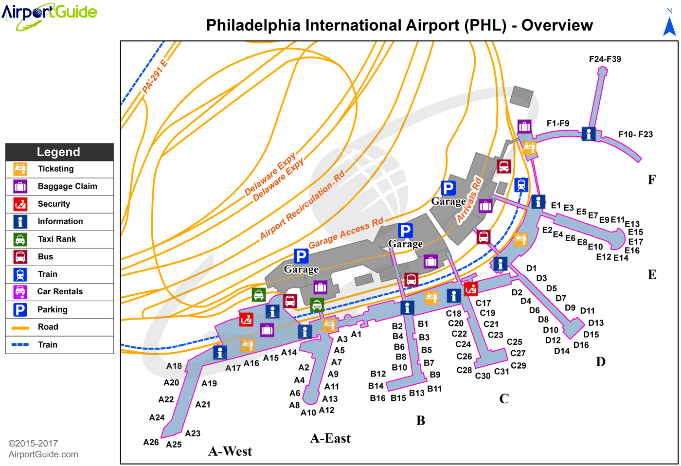
Maps & Diagrams
PHL Sectional
Flight Planning
at skyvector.com
at skyvector.com
 Diagram")