Location
Latitude: |
39-56-34.4000N (39.942889) |
Longitude: |
074-50-44.7000W (-74.84575) |
Elevation: |
52.8 feet MSL (16 m MSL) |
Magnetic Variation: |
12.1 W (as of April 2024 from WMM2020 model) |
Time Zone: |
UTC -5.0 (Standard Time) UTC -4.0 (Daylight Savings Time) |
From City: |
04 N.M. SW of Mount Holly, New Jersey |
Found On: |
Washington Chart |
FAA Region: |
AEA |
Contacts
Manager: |
Publicly owned: |
| MINDY KIMBALL 68 STACY HAINES RD. LUMBERTON, NJ 08048 609-267-3131 |
N.J. DEPT. OF TRANSPORTATION 1035 PARKWAY AVE., P.O. BOX 600 TRENTON, NJ 08625-0600 609-530-2900 |
Operations
Airport Status: |
Operational |
Facility Use: |
Public |
Type: |
Airport |
Activation Date: |
01/1956 |
Control tower: |
No |
Attendance (Months/Days/Hours): |
Months/Days/Hours APR-OCT/ALL/0800-2000 |
Boundary ARTCC: |
ZDC (Washington) |
Responsible ARTCC: |
ZNY (New York) |
Lighting Schedule: |
SEE RMK |
Segmented Circle Indicator: |
Yes |
Traffic Pattern Altitude (MSL): |
1053 feet (321 m) |
NOTAMs Facility: |
VAY |
NOTAM-D Service: |
Yes |
International Airport of Entry: |
No |
Customs Landing Rights: |
No |
Military Landing Rights: |
No |
Civil/Military Joint Use: |
No |
Based Aircraft
| Single Engine: | 71 |
| Multi Engine: | 5 |
| GA Helicopters: | 1 |
Annual Operations (as of 10/30/2023)
| Total Operations: | 34172 | |
| GA Local: | 22225 | 65.0% |
| GA Itinerant: | 11947 | 35.0% |
Communications
| CTAF: | 122.800 |
| Unicom: | 122.800 |
| Approach: | MC GUIRE 126.475 126.475 |
| Departure: | MC GUIRE 126.475 126.475 |
| ASOS: | 119.325 (609-267-1176) |
Fixed Based Operators (FBOs) & Fuel
(Click on a business for detail)
Please help us keep this information up to date. This is a FREE SERVICE just like everything else on Airport Guide! If you see that a business needs to be added, modified, or deleted please fill out our Update Form.
To add, modify, or delete a business click here.
Please help us keep this information up to date. This is a FREE SERVICE just like everything else on Airport Guide! If you see that a business needs to be added, modified, or deleted please fill out our Update Form.
Area Code: 609 |
| Business Name | Frequency | Phone | Fuel Grade |
|---|---|---|---|
| Kenmarson Aero Club
Update FBO info |
Unicom 122.8 | 265-0399 | |
| Sabre Flight Service, Inc.
Update FBO info |
267-3131 | 100LL, Jet A | |
| South Jersey Flyers
Update FBO info |
267-4221 |
Flight Service Stations
| Primary | Alternate | |
| FSS on Field: | N | |
| FSS Name (ID): | Millville(MIV) | |
| Frequency: | ||
| Toll Free Phone: | 1-800-WX-BRIEF |
Instrument Procedures / Charts
FAA Terminal Procedures valid from 0901Z 03/21/24 to 0901Z 04/18/24.
There are various types of charts available for an airport. They are listed in the Page Type column. Here is a legend for those types:
APD - Airport Diagram
DP - Departure Procedure Charts
HOT - Hot Spots
IAP - Instrument Approach Procedure Charts
MIN - Minimums
STAR - Standard Terminal Arrival Charts
| Page Type | Page Name | Volume | Action Since Last Cycle |
|---|---|---|---|
| IAP | RNAV (GPS) RWY 08 | NE-2 | |
| IAP | RNAV (GPS) RWY 26 | NE-2 | |
| IAP | VOR RWY 26 | NE-2 | |
| MIN | ALTERNATE MINIMUMS | NE-2 | |
| MIN | TAKEOFF MINIMUMS | NE-2 | |
| STAR | WAALK TWO (RNAV) | NE-2 | Changed |
| STAR | WAALK TWO (RNAV)[DELIMITER] CONT.1 | NE-2 |
Terminal Procedures are only available for airports in several countries with more being added all the time. If you are looking for a specific country's charts, please send an email to support(at)airportguide.com stating the country name. This will be used to prioritize the implementation.
Navigation Aids (Navaids) near LLY
| Dist (NM) | ID | Morse Code | Name | Type | Freq | True Hdg | Mag Hdg |
|---|---|---|---|---|---|---|---|
| 11.2 | PNE | . _ _ . _ . . | North Philadelphia | VOR | 112.00 | 318 | 330 |
| 12.1 | GXU | _ _ . _ . . _ . . _ | Mc Guire | VORTAC | 110.60 | 70 | 82 |
| 18.5 | PHL | . _ _ . . . . . . _ . . | Philadelphia | VOT | 109.80 | 255 | 267 |
| 18.8 | ARD | . _ . _ . _ . . | Yardley | VOR-DME | 108.20 | 351 | 363 |
| 20.5 | CYN | _ . _ . _ . _ _ _ . | Coyle | VORTAC | 113.40 | 111 | 123 |
| 22.4 | RBV | . _ . _ . . . . . . _ | Robbinsville | VORTAC | 113.80 | 45 | 57 |
| 23.0 | ING | . . _ . _ _ . | Ambler | NDB | 275 | 298 | 310 |
| 23.3 | NEL | _ . . . _ . . | Lakehurst | TACAN | 111.80 | 75 | 87 |
| 24.2 | NEL | _ . . . _ . . | Lakehurst | NDB | 396 | 75 | 87 |
| 24.9 | VCN | . . . _ _ . _ . _ . | Cedar Lake | VOR-DME | 115.20 | 193 | 205 |
| 28.0 | OOD | _ _ _ _ _ _ _ . . | Woodstown | VORTAC | 112.80 | 229 | 241 |
| 31.8 | ACY | . _ _ . _ . _ . _ _ | Atlantic City | VORTAC | 108.60 | 156 | 168 |
| 34.2 | RNB | . _ . _ . _ . . . | Rainbow | NDB | 363 | 203 | 215 |
| 35.6 | UKT | . . _ _ . _ _ | Quakertown | NDB | 208 | 324 | 336 |
| 36.8 | PTW | . _ _ . _ . _ _ | Pottstown | VORTAC | 116.50 | 297 | 309 |
| 38.0 | MXE | _ _ _ . . _ . | Modena | VORTAC | 113.20 | 268 | 280 |
| 38.5 | COL | _ . _ . _ _ _ . _ . . | Colts Neck | VOR-DME | 115.40 | 54 | 66 |
| 38.5 | DQO | _ . . _ _ . _ _ _ _ | Dupont | VORTAC | 114.00 | 245 | 257 |
| 38.7 | SBJ | . . . _ . . . . _ _ _ | Solberg | VOR-DME | 112.90 | 7 | 19 |
| 41.5 | IL | . . . _ . . | Hadin | NDB | 248 | 238 | 250 |
Nearby Airports with Fuel
Notices to Airmen (NOTAMS)
Remarks
| A110-1 | TREES ALONG SIDES OF RY PRIMARILY NW. |
| A110-2 | BALLS MKG PLINES ON APH TO RY 08 FADED. |
| A110-3 | DEER ON & INVOF ARPT. |
| A110-4 | HELICOPTER TAKEOFFS AND LANDINGS RESTRICTED TO RY 08/26 ONLY. |
| A110-7 | PARALLEL TAXIWAY NON-STANDARD WIDTH, 18 FT ASP. |
| A110-8 | AVOID OVERFLYING HOUSING AREA WNW OF ARPT BELOW 300 FT WHEN IN THE TRAFFIC PATTERN FOR RWY 8. |
| A110-9 | FOR CD CTC MC GUIRE APCH AT 609-754-2767. |
| A17 | ARPT UNATNDD THANKSGIVING & CHRISTMAS DAY. CHRISTMAS & THANKSGIVING EVE HRS 0800-1200. NEW YEARS DAY HRS 1100-1800. |
| A43-08 | VGSI AND DESCENT ANGLES NOT COINCIDENT. |
| A70-FUEL-A | JET A AVAILABLE 24-HOUR SELF SERVICE WITH CREDIT CARD OR TRUCK DURING ATTENDED HOURS. |
| A81-APT | ACTVT MIRL RY 08/26 AND REIL RY 08 & 26 -123.3. |
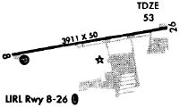
Runways
Runway Summary
| Runways: | 08/26 |
| Longest Runway: | 08/26 is 3881 ft (1183 m) long |
| Runways with an Instrument Approach: |
LLY Heliport Runway Details
| Runway 08/26 | 3881 ft x 50 ft (1183 m x 15 m) | |
| Runway Length Source: | 3RD PARTY SURVEY as of 07/29/2012 | |
| Surface: | Asphalt - Good condition - No special surface treatment | |
| Runway Edge Lights: | Medium Intensity | |
Runway Weight Bearing Capacity (in thousands of pounds) |
||
| Single Wheel Landing Gear: | 30.0 | |
Runway 08 |
Runway 26 |
|
Elevation: |
43.8 | 51.8 |
Latitude: |
39-56-27.7455N | 39-56-40.9832N |
Longitude: |
074-51-08.0995W | 074-50-21.3332W |
|
Runway True Alignment: |
070 | 250 |
Glide Path Angle: |
3.2 degrees | 3.0 degrees |
Traffic Pattern: |
Left | Right |
Runway Markings Type: |
Nonprecision Instrument | Nonprecision Instrument |
Runway Markings Condition: |
Fair | Fair |
Object at End: |
TREE | TREE |
Object Height: |
54 | 45 |
Distance from End: |
550 | 909 |
Object Centerline Offset: |
170 ft. right of centerline | 99 ft. left of centerline |
Visual Glide Slope Indicators: |
2-Light PAPI On Right Side Of Runway | 2-Light PAPI On Right Side Of Runway |
REIL: |
Yes | Yes |
Touchdown Lights: |
No | No |
Centerline Lights: |
No | No |
Threshold Crossing Height: |
45 | 40 |
Services
Airframe Repair: |
Major |
Powerplant Repair: |
Major |
Fuel Available: |
Jet A |
Landing Fees: |
No |
Parking: |
Hangars and tiedowns available |
Maps & Diagrams
LLY Sectional
Flight Planning
at skyvector.com
at skyvector.com