Location
Latitude: |
36-27-27.2850N (36.457579) |
Longitude: |
082-53-06.1230W (-82.885034) |
Elevation: |
1254.6 feet MSL (382 m MSL) |
Magnetic Variation: |
6.8 W (as of May 2024 from WMM2020 model) |
Time Zone: |
UTC -5.0 (Standard Time) UTC -4.0 (Daylight Savings Time) |
From City: |
06 N.M. NE of Rogersville, Tennessee |
Found On: |
Cincinnati Chart |
FAA Region: |
ASO |
Contacts
Manager: |
Publicly owned: |
| MARK FINLEY 675 MAIN ST SURGOINSVILLE, TN 37873 423-345-0219 |
HAWKINS COUNTY COURTHOUSE, 150 WASHINGTON ST ROGERSVILLE, TN 37857 423-272-7359 |
Operations
Airport Status: |
Operational |
Facility Use: |
Public |
Type: |
Airport |
Activation Date: |
07/1965 |
Control tower: |
No |
Attendance (Months/Days/Hours): |
Months/Days/Hours ALL/ALL/0800-1700 |
Boundary ARTCC: |
ZTL (Atlanta) |
Responsible ARTCC: |
ZTL (Atlanta) |
Segmented Circle Indicator: |
Yes |
Traffic Pattern Altitude (MSL): |
2255 feet (687 m) |
NOTAMs Facility: |
BNA |
NOTAM-D Service: |
Yes |
International Airport of Entry: |
No |
Customs Landing Rights: |
No |
Military Landing Rights: |
Yes |
Civil/Military Joint Use: |
No |
Based Aircraft
| Single Engine: | 20 |
Annual Operations (as of 07/27/2021)
| Total Operations: | 1000 | |
| Air Taxi: | 12 | 1.2% |
| GA Local: | 556 | 55.6% |
| GA Itinerant: | 428 | 42.8% |
| Military Aircraft: | 4 | 0.4% |
Communications
| CTAF: | 122.800 |
| Unicom: | 122.800 |
| Approach: | TRI CITY 128.05 128.05 ATLANTA ARTCC |
| Departure: | TRI CITY 128.05 128.05 ATLANTA ARTCC |
- APCH/DEP SVC PRVDD BY ATLANTA ARTCC ON FREQS 127.85/269.3 (GLADE SPRINGS RCAG) WHEN TRI CITY APCH CTL CLSD.
Fixed Based Operators (FBOs) & Fuel
(Click on a business for detail)
Please help us keep this information up to date. This is a FREE SERVICE just like everything else on Airport Guide! If you see that a business needs to be added, modified, or deleted please fill out our Update Form.
To add, modify, or delete a business click here.
Please help us keep this information up to date. This is a FREE SERVICE just like everything else on Airport Guide! If you see that a business needs to be added, modified, or deleted please fill out our Update Form.
Area Code: 423 |
| Business Name | Frequency | Phone | Fuel Grade |
|---|
Flight Service Stations
| Primary | Alternate | |
| FSS on Field: | N | |
| FSS Name (ID): | Nashville(BNA) | |
| Frequency: | ||
| Toll Free Phone: | 1-800-WX-BRIEF |
Instrument Procedures / Charts
FAA Terminal Procedures valid from 0901Z 03/21/24 to 0901Z 04/18/24.
There are various types of charts available for an airport. They are listed in the Page Type column. Here is a legend for those types:
APD - Airport Diagram
DP - Departure Procedure Charts
HOT - Hot Spots
IAP - Instrument Approach Procedure Charts
MIN - Minimums
STAR - Standard Terminal Arrival Charts
| Page Type | Page Name | Volume | Action Since Last Cycle |
|---|---|---|---|
| IAP | RNAV (GPS) RWY 07 | SE-1 | |
| IAP | RNAV (GPS) RWY 25 | SE-1 | |
| MIN | TAKEOFF MINIMUMS | SE-1 |
Terminal Procedures are only available for airports in several countries with more being added all the time. If you are looking for a specific country's charts, please send an email to support(at)airportguide.com stating the country name. This will be used to prioritize the implementation.
Navigation Aids (Navaids) near KRVN
| Dist (NM) | ID | Morse Code | Name | Type | Freq | True Hdg | Mag Hdg |
|---|---|---|---|---|---|---|---|
| 0.1 | RVN | . _ . . . . _ _ . | Rogersville | NDB | 329 | 163 | 170 |
| 19.1 | BO | _ . . . _ _ _ | Booie | NDB | 221 | 100 | 107 |
| 19.3 | DYQ | _ . . _ . _ _ _ _ . _ | Dulaney | NDB | 263 | 180 | 187 |
| 28.0 | TR | _ . _ . | Mocca | NDB | 299 | 77 | 84 |
| 30.9 | EZT | . _ _ . . _ | Elizabethton | NDB | 275 | 105 | 112 |
| 35.3 | JXT | . _ _ _ _ . . _ _ | Jefferson | NDB | 346 | 234 | 241 |
| 36.5 | HMV | . . . . _ _ . . . _ | Holston Mountain | VORTAC | 114.60 | 91 | 98 |
| 40.9 | SOT | . . . _ _ _ _ | Snowbird | VORTAC | 108.80 | 191 | 198 |
| 44.6 | GZG | _ _ . _ _ . . _ _ . | Glade Spring | VOR-DME | 110.20 | 60 | 67 |
| 48.1 | VJ | . . . _ . _ _ _ | Whine | NDB | 236 | 69 | 76 |
| 51.9 | BAR | _ . . . . _ . _ . | Hemlock | NDB | 320 | 110 | 117 |
| 57.3 | IM | . . _ _ | Keans | NDB | 357 | 165 | 172 |
| 58.9 | AZQ | . _ _ _ . . _ _ . _ | Hazard | DME | 111.2 | 342 | 349 |
| 59.1 | VXV | . . . _ _ . . _ . . . _ | Volunteer | VORTAC | 116.40 | 236 | 242 |
| 66.2 | TYS | _ _ . _ _ . . . | Knoxville | VOT | 112.00 | 234 | 240 |
| 68.3 | LOZ | . _ . . _ _ _ _ _ . . | London | VOR-DME | 116.55 | 300 | 306 |
| 69.8 | SUG | . . . . . _ _ _ . | Sugarloaf Mountain | VORTAC | 112.20 | 154 | 161 |
| 72.8 | MRN | _ _ . _ . _ . | Lenoir | FAN MARKER | 122 | 129 | |
| 73.9 | BRA | _ . . . . _ . . _ | Broad River | NDB | 379 | 164 | 171 |
| 74.0 | FIQ | . . _ . . . _ _ . _ | Fiddlers | NDB | 391 | 126 | 133 |
Nearby Airports with Fuel
Notices to Airmen (NOTAMS)
Remarks
| A110-2 | DEER ON & INVOF ARPT. |
| A110-4 | FOR CD CTC ATLANTA ARTCC AT 770-210-7692. |
| A17 | UNATNDD MAJOR HOL. |
| A30A-07 | 3118 FT MT RIDGE SE OF ARPT WI 9 NM. |
| A70-FUEL-10 | 0LL H24 SELF SVC FUEL AVBL. |
Runways
Runway Summary
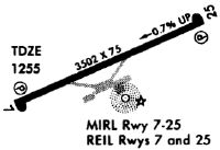
| Runways: | 07/25 |
| Longest Runway: | 07/25 is 3504 ft (1068 m) long |
| Runways with an Instrument Approach: |
KRVN Airport Runway Details
| Runway 07/25 | 3504 ft x 75 ft (1068 m x 23 m) | |
| Runway Length Source: | 3RD PARTY SURVEY as of 06/24/2019 | |
| Surface: | Asphalt - Fair condition - No special surface treatment | |
| Runway Edge Lights: | Medium Intensity | |
Runway Weight Bearing Capacity (in thousands of pounds) |
||
| Single Wheel Landing Gear: | 25.0 | |
Runway 07 |
Runway 25 |
|
Elevation: |
1254.5 | 1229.8 |
Latitude: |
36-27-19.7082N | 36-27-34.8602N |
Longitude: |
082-53-25.4043W | 082-52-46.8403W |
|
Runway True Alignment: |
064 | 244 |
Glide Path Angle: |
3.0 degrees | 3.0 degrees |
Traffic Pattern: |
Left | Left |
Runway Markings Type: |
Nonprecision Instrument | Nonprecision Instrument |
Runway Markings Condition: |
Fair | Fair |
Object at End: |
TREES | TREES |
Object Height: |
24 | 40 |
Distance from End: |
632 | 1158 |
Object Centerline Offset: |
144 ft. right of centerline | 88 ft. left of centerline |
Visual Glide Slope Indicators: |
2-Light PAPI On Left Side Of Runway | 2-Light PAPI On Left Side Of Runway |
REIL: |
Yes | Yes |
Touchdown Lights: |
No | No |
Centerline Lights: |
No | No |
Threshold Crossing Height: |
25 | 29 |
Services
Airframe Repair: |
Major |
Powerplant Repair: |
Major |
Bottled Oxygen: |
None |
Bulk Oxygen: |
None |
Fuel Available: |
100LL |
Landing Fees: |
No |
Parking: |
Hangars and tiedowns available |
Maps & Diagrams
KRVN Sectional
Flight Planning
at skyvector.com
at skyvector.com