Location
Latitude: |
36-04-48.1580N (36.080044) |
Longitude: |
115-09-08.0450W (-115.152235) |
Elevation: |
2181.2 feet MSL (665 m MSL) |
Magnetic Variation: |
11.1 E (as of April 2024 from WMM2020 model) |
Time Zone: |
UTC -8.0 (Standard Time) UTC -7.0 (Daylight Savings Time) |
From City: |
05 N.M. S of Las Vegas, Nevada |
Found On: |
Las Vegas Chart |
FAA Region: |
AWP |
Contacts
Manager: |
Publicly owned: |
| ROSEMARY A. VASSILIADIS 5757 WAYNE NEWTON BLVD LAS VEGAS, NV 89119 702-261-5211 |
CLARK COUNTY P O BOX 11005 LAS VEGAS, NV 89111 702-261-5211 |
Operations
Airport Status: |
Operational |
Facility Use: |
Public |
Type: |
Airport |
Activation Date: |
01/1947 |
Control tower: |
Yes |
Attendance (Months/Days/Hours): |
Months/Days/Hours ALL/ALL/ALL |
Boundary ARTCC: |
ZLA (Los Angeles) |
Responsible ARTCC: |
ZLA (Los Angeles) |
Lighting Schedule: |
SS-SR |
Segmented Circle Indicator: |
No |
Traffic Pattern Altitude (MSL): |
3181 feet (970 m) |
NOTAMs Facility: |
LAS |
NOTAM-D Service: |
Yes |
International Airport of Entry: |
No |
Customs Landing Rights: |
Yes |
Military Landing Rights: |
Yes |
Civil/Military Joint Use: |
No |
Aircraft Rescue and Firefighting: |
Class I ARFF Index: E Air Carrier Service: Scheduled Certification Date: 05/1973 |
Based Aircraft
| Single Engine: | 2 |
| Multi Engine: | 3 |
| Jet Engine: | 138 |
| GA Helicopters: | 45 |
Annual Operations (as of 12/31/2022)
| Total Operations: | 656265 | |
| Commercial: | 370860 | 56.5% |
| Air Taxi: | 160554 | 24.5% |
| GA Itinerant: | 110777 | 16.9% |
| Military Aircraft: | 14074 | 2.1% |
Communications
| Unicom: | 122.950 |
| Tower: | LAS VEGAS 118.75 ;RWY 01L/19R, 01R/19L 119.9 ;RWY 08L/26R, 08R/26L 257.8 Hrs: 24 |
| Clearance Del.: | 118.0 |
| Ground: | 121.1 ;E OF RWY 01R/19L 121.9 ;W OF RWY 01R/19L 254.3 ;W OF RWY 01L/19R 270.8 ;E OF RWY 01R/19L |
| Approach: | LAS VEGAS |
| Departure: | LAS VEGAS |
| ATIS: | 132.4 ;ARR/DEP Hrs: 24 |
| ASOS: | (725-600-7124) |
| EMERG: | 243.0 |
| EMERG: | 121.5 |
| RAMP CTL: | 124.4 ;A, B, C GATES & GA, CUSTOMS. |
| RAMP CTL: | 127.9 ;D, E GATES & CARGO. |
| RAMP CTL: | 130.0 ;RAMP ALTERNATE FREQUENCY |
- RAMP CON (1 OF 2): OPS AT ALL TRML GATES AND CARGO RAMP CTLD BY DEPT OF AVIATION 1300-0900Z++. ALL ACFT CTC RAMP CTL ON FREQ 124.4 FOR OPS AT A,B,C GATES AND GA CUSTOMS; CTC RAMP CTL127.9 FOR OPS AT D & E GATES AND CARGO RAMP PRIOR TO ENTERING RAMP OR PUSHING BACK FROM GATE OR PRKG SPOT. RAMP CTL OPER HRS 1300-0900Z++. BROADCAST ON UNICOM 122.95 FM 0900-1300Z++ FOR RAMP OPS.
- RAMP CON (2 OF 2): FROM 0100-0530 CTC GND CON ON FREQ 121.1 FOR OPS AT ALL GATES AND CARGO RAMP.
Fixed Based Operators (FBOs) & Fuel
(Click on a business for detail)
Please help us keep this information up to date. This is a FREE SERVICE just like everything else on Airport Guide! If you see that a business needs to be added, modified, or deleted please fill out our Update Form.
To add, modify, or delete a business click here.
Please help us keep this information up to date. This is a FREE SERVICE just like everything else on Airport Guide! If you see that a business needs to be added, modified, or deleted please fill out our Update Form.
Area Code: 702 |
| Business Name | Frequency | Phone | Fuel Grade |
|---|---|---|---|
| CFI, Inc.
Update FBO info |
736-2559, -0077 | ||
| Eagle Las Vegas Executive Air Terminal
Update FBO info |
Unicom 122.95, Arinc 128.85 | 736-1830, 800-726-2810 | 100LL, Jet A |
| Interstate Tours
Update FBO info |
736-4554 | ||
| Signature Flight Support
Website Update FBO info |
Unicom 122.95, Arinc 128.87 | +1 702 739 1100 | 100LL, Jet A |
| Sundance Helicopters
Update FBO info |
736-0606 |
Flight Service Stations
| Primary | Alternate | |
| FSS on Field: | N | |
| FSS Name (ID): | Reno(RNO) | |
| Frequency: | ||
| Toll Free Phone: | 1-800-WX-BRIEF |
Instrument Procedures / Charts
FAA Terminal Procedures valid from 0901Z 03/21/24 to 0901Z 04/18/24.
There are various types of charts available for an airport. They are listed in the Page Type column. Here is a legend for those types:
APD - Airport Diagram
DP - Departure Procedure Charts
HOT - Hot Spots
IAP - Instrument Approach Procedure Charts
MIN - Minimums
STAR - Standard Terminal Arrival Charts
Terminal Procedures are only available for airports in several countries with more being added all the time. If you are looking for a specific country's charts, please send an email to support(at)airportguide.com stating the country name. This will be used to prioritize the implementation.
Navigation Aids (Navaids) near LAS
| Dist (NM) | ID | Morse Code | Name | Type | Freq | True Hdg | Mag Hdg |
|---|---|---|---|---|---|---|---|
| 0.4 | LAS | . _ . . . _ . . . | Las Vegas | VORTAC | 116.90 | 266 | 255 |
| 8.0 | VGT | . . . _ _ _ . _ | North Las Vegas | VOT | 108.20 | 347 | 336 |
| 11.6 | LSV | . _ . . . . . . . . _ | Nellis | TACAN | 135.50 | 31 | 20 |
| 14.9 | BLD | _ . . . . _ . . _ . . | Boulder City | VORTAC | 116.70 | 109 | 98 |
| 20.1 | GOG | _ _ . _ _ _ _ _ . | Goodsprings | DME | 112.05 | 236 | 225 |
| 39.3 | INS | . . _ . . . . | Indian Springs | TACAN | 114.00 | 320 | 309 |
| 56.9 | GFS | _ _ . . . _ . . . . | Goffs | VORTAC | 114.40 | 181 | 170 |
| 59.1 | MMM | _ _ _ _ _ _ | Mormon Mesa | VORTAC | 113.10 | 45 | 34 |
| 77.0 | LMX | . _ . . _ _ _ . . _ | Alamo | DME | 113.65 | 358 | 347 |
| 77.1 | IGM | . . _ _ . _ _ | Kingman | VOR-DME | 108.80 | 129 | 118 |
| 82.8 | PGS | . _ _ . _ _ . . . . | Peach Springs | VOR-DME | 112.00 | 108 | 97 |
| 85.5 | EED | . . _ . . | Needles | VORTAC | 115.20 | 156 | 145 |
| 88.3 | BTY | _ . . . _ _ . _ _ | Beatty | VORTAC | 114.70 | 299 | 288 |
| 96.7 | DAG | _ . . . _ _ _ . | Daggett | VORTAC | 113.20 | 226 | 215 |
| 96.8 | UTI | . . _ _ . . | St George | VOR-DME | 108.60 | 53 | 42 |
Nearby Airports with Fuel
| Dist (NM) | Name (Airport IDs) | True Hdg | Mag Hdg | Fuel Grade |
|---|---|---|---|---|
| 6.5 | Henderson Exec Airport (HSH KHND HND) |
172 | 161 | 100LL, Jet A |
| 8.1 | North Las Vegas Airport (VGT KVGT VGT) |
345 | 334 | 100LL, Jet A |
| 16.2 | Boulder City Municipal Airport (BLD KBVU BVU) |
119 | 108 | 100LL, Jet A |
| 20.6 | Jean Airport (0L7) |
204 | 193 | 100LL, Jet A |
| 28.8 | Sky Ranch Airport (3L2) |
233 | 222 | 100LL |
| 45.1 | Perkins Field Airport (U08) |
49 | 38 | 100LL |
| 48.3 | Kidwell Airport (1L4) |
164 | 153 | 100LL |
| 62.6 | Laughlin/Bullhead International Airport (IFP KIFP IFP) |
152 | 141 | 100LL, Jet A |
| 69.6 | Mesquite Airport (MFH 67L) |
49 | 38 | 100LL, Jet A |
| 70.6 | Sun Valley Airport (A20) |
155 | 144 | 100LL |
| 76.1 | Eagle Airpark Airport (A09) |
159 | 148 | 100LL, Jet A |
| 77.0 | Kingman Airport (IGM KIGM IGM) |
129 | 118 | 100LL, Jet A |
| 83.0 | Needles Airport (EED KEED EED) |
161 | 150 | 100LL, Jet A |
| 86.6 | Furnace Creek Airport (L06) |
285 | 273 | 100LL |
| 97.7 | St George Regional Airport (SGU KDXZ SGU) |
53 | 42 | 100LL, Jet A |
| 98.5 | Lake Havasu City Airport (HII KHII HII) |
156 | 145 | 100LL, Jet A |
Notices to Airmen (NOTAMS)
Remarks
| A110-1 | EXTSV GLDR/SOARING OPNS WKENDS & HOLS; SR-SS; LAS R187/020; ALTS UP TO BUT NOT INCLG FL180. GLDRS RMN CLEAR OF THE TCA BUT OTHERWISE OPR WI THE ENTIRE SW QUAD OF THE TCA VEIL. |
| A110-10 | LGTD GOLF RANGE 1400 FT S OF RWYS 01L/19R AND 01R/19L. |
| A110-11 | TIEDOWN FEE. |
| A110-13 | (E98) PLUS 64 SHELTERS & 24 SHEDS. |
| A110-2 | ALL NON-STD RWY OPNS PPR FM DEPT OF AVN. |
| A110-20 | ACFT USING FULL LEN DEP ON RWY 08L USE MINIMAL PWR TIL PASSING THE PWR-UP POINT ON RWY. PWR-UP POINT IS 348 FT EAST OF BLAST PAD AND MKD WITH SIGN AND STD MARKINGS FOR BGNG OF RWY. |
| A110-25 | LRG NR OF BIRDS AND BATS INVOF OF ARPT BTWN SS AND SR. |
| A110-28 | ACFT DEPG RWY 19R USE MINIMAL PWR UNTIL PASSING THE RWY THLD. RWY 19R THLD HAS STD RWY MARKINGS AND IS 780 FT S OF THE BLAST PAD. |
| A110-3 | TBJT DEPS NOT PMTD ON RWY 01R/19L OR RWY 01L/19R 2000-0800. XCPNS FOR WX OR OPNL NECESSITY. |
| A110-30 | ACFT OPER NEAR THE INT OF TWYS S, D, G AND THE N END OF TWY Z SHOULD BE ALERT AS THERE ARE CLOSELY ALIGNED TWY CNTRLN AND RADIUS TURNS. |
| A110-31 | ACFT THAT DEP FULL LENGTH OF RWYS 01L AND 08L MUST HOLD AT THE SAME HOLD LINE AS THERE IS NO ROOM TO HOLD BTN THE RWY ENDS AND SUCH ACFT SHOULD VERIFY THAT THEY ARE ON THE CORRECT RWY. |
| A110-32 | GA CUST AND IMG LCTD WEST SIDE OF AFLD BTWN FBO'S. |
| A110-33 | ACFT WITH WINGSPAN GTR THAN 135 FT PPR FM DEPT OF AVN TO USE TWY H. |
| A110-34 | NMRS HOP ON WEST SIDE OF ARPT. |
| A110-36 | ASDE-X IN USE. OPERATE TRANSPONDERS WITH ALTITUDE REPORTING MODE AND ADS-B (IF EQUIPPED) ENABLED ON ALL AIRPORT SURFACES. |
| A110-37 | GA CBP RSVNS ARE RQRD TO BE SMTD A MIN OF 12 HOURS IN ADVN (OTHER CONDS APPLY). RSVNS MUST BE MADE ONLINE AT WWW.MCCARRAN.COM/GACBP . QNS CAN BE DCTD TO CBP559@MCCARRAN.COM. |
| A110-38 | ACFT TAX WB ON TWY B NEAR TWY E USE CARE NOT TO ENTER THE RWY ON TWY Y, ACFT TAX WB ON TWY W NEAR TWY E USE CARE NOT TO ENTER THE RWY ON TWY U. |
| A110-4 | ACFT MAY EXPERIENCE REFLECTION OF SUN FM GLASS HOTELS LCTD NW OF ARPT. REFLECTION MAY OCCUR AT VARIOUS ALTS, HDGS, & DSTCS FM ARPT. |
| A110-40 | ALL ACFT CTC RAMP CTL ON FREQ 124.4 FOR OPS AT A, B, C GATES, AND GA, CUSTOMS; CTC RAMP CTL FREQ 127.9 FOR OPNS AT D AND E GATES AND CARGO RAMP PRIOR TO ENTERING RAMP OR PUSHING BACK FM GATE OR PRKG SPOT. RAMP CTL OPR HRS 1300-0900Z. WHEN RAMP IS CLSD (0900-1300Z) BROADCAST ALL NON-MOVEMENT AREA OPNS ON UNICOM 122.95. |
| A110-41 | RWY STS LGTS ARE IN OPN. |
| A110-42 | PLA AUZD BTN 0200 & 0600. |
| A110-43 | CTN PAJA INVOF ARPT. |
| A110-44 | WHEN SPL EVENT PRKG PPR PROGRAM NOTAM IS ACTV, TSNT ACFT OPERS NOT PERM BASED NEED TO OBTAIN A PPR NR FM AN FBO FOR EA LDG. PPR APPVL & CONFIRMATION NRS CAN BE OBTAINED FM THE SEL FBO AT 702-261-7775. PPR CONFIRMATION NRS SHOULD BE ENTERED IN THE RMKS SECTION OF EACH FLT PLAN. |
| A110-6 | GA PRKG VERY LTD. FOR PRKG AVAILABILITY CTC EITHER FBO (702) 736-1830 OR (702) 739-1100. |
| A110-8 | RWY 08L 589 FT CWY; RWY 26R 645 FT CWY. |
| A14 | ARPT OPS 24-HR CTC (702) 261-5605. |
| A57-01L | APCH RATIO 34:1 TO DTHR. |
| A57-01R | APCH RATIO 23:1 TO DTHR. |
| A57-08L | APCH RATIO 50:1 TO DTHR. |
| A57-19L | APCH RATIO 50:1 TO DTHR. |
| A57-19R | APCH RATIO 20:1 TO DTHR. |
| E80 | LANDING RIGHTS AIRPORT: CUSTOMS AVBL TO GENERAL AVIATION ACFT MON-SAT 0800-2300; SUN 0800-1200 & 1700-2300. |
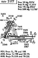
Runways
Runway Summary
| Runways: | 01L/19R 01R/19L 08L/26R 08R/26L |
| Longest Runway: | 08L/26R is 14515 ft (4424 m) long |
| Runways with an Instrument Approach: | 01L, 26R, 26L |
LAS Airport Runway Details
| Runway 01L/19R | 8988 ft x 150 ft (2740 m x 46 m) | |
| Runway Length Source: | 3RD PARTY SURVEY as of 11/21/2018 | |
| Surface: | Concrete - Good condition - Saw-cut or plastic grooved | |
| Runway Pavement Class: | 100/R/B/W/T | |
| Runway Edge Lights: | High Intensity | |
Runway Weight Bearing Capacity (in thousands of pounds) |
||
| Single Wheel Landing Gear: | 120.0 | |
| Dual Wheel Landing Gear: | 250.0 | |
| Dual Tandem Wheel Landing Gear: | 550.0 | |
| Dual Dual Tandem Wheel Landing Gear: | 1120.0 | |
Runway 01L |
Runway 19R |
|
Elevation: |
2181.2 | 2088.5 |
Latitude: |
36-04-31.1684N | 36-05-51.7658N |
Longitude: |
115-10-13.3148W | 115-09-27.1851W |
|
Runway True Alignment: |
025 | 205 |
ILS Type: |
ILS/DME | |
Glide Path Angle: |
3.4 degrees | 3.0 degrees |
Traffic Pattern: |
Left | Right |
Runway Markings Type: |
Precision Instrument | Nonprecision Instrument |
Runway Markings Condition: |
Good | Good |
Object at End: |
RR | FENCE |
Object Height: |
48 | 25 |
Distance from End: |
1225 | 190 |
Object Centerline Offset: |
500 ft. left of centerline | 150 ft. right of centerline |
Visual Glide Slope Indicators: |
4-Light PAPI On Left Side Of Runway | 4-Light PAPI On Left Side Of Runway |
Approach Light System: |
1,400 Foot Medium Intensity Approach Lighting System With Sequenced Flashers | |
REIL: |
No | Yes |
Touchdown Lights: |
No | No |
Centerline Lights: |
No | No |
Threshold Crossing Height: |
63 | 80 |
Threshold Elevation: |
2176.1 | |
Displaced Threshold: |
587 | |
Threshold Latitude: |
36-04-36.4357N | |
Threshold Longitude: |
115-10-10.3026W | |
Declared Distances |
||
Take Off Run Avbl. (TORA): |
8988 | 8988 |
Take Off Distance Avbl. (TODA): |
8988 | 9400 |
Actual Stop Dist. Avbl. (ASDA): |
8988 | 8417 |
Landing Dist. Avbl. (LDA): |
8401 | 8417 |
| Runway 01R/19L | 9771 ft x 150 ft (2978 m x 46 m) | |
| Runway Length Source: | 3RD PARTY SURVEY as of 11/21/2018 | |
| Surface: | Concrete - Good condition - Saw-cut or plastic grooved | |
| Runway Pavement Class: | 100/R/B/W/T | |
| Runway Edge Lights: | Medium Intensity | |
Runway Weight Bearing Capacity (in thousands of pounds) |
||
| Single Wheel Landing Gear: | 120.0 | |
| Dual Wheel Landing Gear: | 250.0 | |
| Dual Tandem Wheel Landing Gear: | 550.0 | |
| Dual Dual Tandem Wheel Landing Gear: | 1120.0 | |
Runway 01R |
Runway 19L |
|
Elevation: |
2175.1 | 2077.6 |
Latitude: |
36-04-27.2640N | 36-05-54.8814N |
Longitude: |
115-10-02.9581W | 115-09-12.8055W |
|
Runway True Alignment: |
025 | 205 |
Glide Path Angle: |
3.0 degrees | 3.0 degrees |
Traffic Pattern: |
Right | Left |
Runway Markings Type: |
Nonprecision Instrument | Nonprecision Instrument |
Runway Markings Condition: |
Good | Good |
Object at End: |
RR | POLE |
Object Height: |
41 | 17 |
Distance from End: |
825 | 929 |
Object Centerline Offset: |
500 ft. left of centerline | 150 ft. right of centerline |
Visual Glide Slope Indicators: |
4-Light PAPI On Left Side Of Runway | 4-Light PAPI On Left Side Of Runway |
REIL: |
Yes | Yes |
Touchdown Lights: |
No | No |
Centerline Lights: |
No | No |
Threshold Crossing Height: |
76 | 75 |
Threshold Elevation: |
2169.8 | 2080.1 |
Displaced Threshold: |
491 | 878 |
Threshold Latitude: |
36-04-31.6705N | 36-05-47.0076N |
Threshold Longitude: |
115-10-00.4361W | 115-09-17.3137W |
Declared Distances |
||
Take Off Run Avbl. (TORA): |
9771 | 9771 |
Take Off Distance Avbl. (TODA): |
10168 | 10171 |
Actual Stop Dist. Avbl. (ASDA): |
9276 | 9686 |
Landing Dist. Avbl. (LDA): |
8785 | 8808 |
| Runway 08L/26R | 14515 ft x 150 ft (4424 m x 46 m) | |
| Runway Length Source: | 3RD PARTY SURVEY as of 11/21/2018 | |
| Surface: | Concrete - Good condition - Saw-cut or plastic grooved | |
| Runway Pavement Class: | 96 /R/B/W/T | |
| Runway Edge Lights: | High Intensity | |
Runway Weight Bearing Capacity (in thousands of pounds) |
||
| Single Wheel Landing Gear: | 120.0 | |
| Dual Wheel Landing Gear: | 250.0 | |
| Dual Tandem Wheel Landing Gear: | 550.0 | |
| Dual Dual Tandem Wheel Landing Gear: | 1120.0 | |
Runway 08L |
Runway 26R |
|
Elevation: |
2179.2 | 2033.0 |
Latitude: |
36-04-34.9211N | 36-04-35.0633N |
Longitude: |
115-10-12.6889W | 115-07-15.8989W |
|
Runway True Alignment: |
090 | 270 |
ILS Type: |
ILS/DME | |
Glide Path Angle: |
3.0 degrees | 3.0 degrees |
Traffic Pattern: |
Left | Left |
Runway Markings Type: |
Nonprecision Instrument | Precision Instrument |
Runway Markings Condition: |
Good | Good |
Object at End: |
HANGAR | |
Object Height: |
25 | |
Distance from End: |
200 | |
Object Centerline Offset: |
500 ft. left of centerline | 150 ft. right of centerline |
Visual Glide Slope Indicators: |
4-Light PAPI On Left Side Of Runway | 4-Light PAPI On Left Side Of Runway |
Approach Light System: |
1,400 Foot Medium Intensity Approach Lighting System | |
REIL: |
No | No |
Touchdown Lights: |
No | No |
Centerline Lights: |
No | No |
Threshold Crossing Height: |
76 | 84 |
Threshold Elevation: |
2154.9 | 2043.5 |
Displaced Threshold: |
2139 | 1399 |
Threshold Latitude: |
36-04-34.9466N | 36-04-35.0526N |
Threshold Longitude: |
115-09-46.6318W | 115-07-32.9389W |
Declared Distances |
||
Take Off Run Avbl. (TORA): |
14515 | 14515 |
Take Off Distance Avbl. (TODA): |
15099 | 15037 |
Actual Stop Dist. Avbl. (ASDA): |
14099 | 14037 |
Landing Dist. Avbl. (LDA): |
11960 | 12638 |
| Runway 08R/26L | 10526 ft x 150 ft (3208 m x 46 m) | |
| Runway Length Source: | 3RD PARTY SURVEY as of 11/21/2018 | |
| Surface: | Concrete - Good condition - Saw-cut or plastic grooved | |
| Runway Pavement Class: | 100/R/B/W/T | |
| Runway Edge Lights: | High Intensity | |
Runway Weight Bearing Capacity (in thousands of pounds) |
||
| Single Wheel Landing Gear: | 120.0 | |
| Dual Wheel Landing Gear: | 250.0 | |
| Dual Tandem Wheel Landing Gear: | 550.0 | |
| Dual Dual Tandem Wheel Landing Gear: | 1120.0 | |
Runway 08R |
Runway 26L |
|
Elevation: |
2156.9 | 2048.4 |
Latitude: |
36-04-25.0637N | 36-04-25.1671N |
Longitude: |
115-09-41.1617W | 115-07-32.9665W |
|
Runway True Alignment: |
090 | 270 |
ILS Type: |
ILS/DME | |
Glide Path Angle: |
3.0 degrees | 3.0 degrees |
Runway Markings Type: |
Nonprecision Instrument | Precision Instrument |
Runway Markings Condition: |
Good | Good |
Object at End: |
POLE | |
Object Height: |
53 | |
Distance from End: |
1257 | |
Object Centerline Offset: |
500 ft. left of centerline | 150 ft. right of centerline |
Visual Glide Slope Indicators: |
4-Light PAPI On Left Side Of Runway | 4-Light PAPI On Left Side Of Runway |
Approach Light System: |
1,400 Foot Medium Intensity Approach Lighting System With Sequenced Flashers | |
REIL: |
Yes | |
Threshold Crossing Height: |
61 | 84 |
Declared Distances |
||
Take Off Run Avbl. (TORA): |
10526 | 10526 |
Take Off Distance Avbl. (TODA): |
10526 | 10526 |
Actual Stop Dist. Avbl. (ASDA): |
10526 | 10526 |
Landing Dist. Avbl. (LDA): |
10526 | 10526 |
Services
Airframe Repair: |
Major |
Powerplant Repair: |
Major |
Bottled Oxygen: |
Low Pressure |
Bulk Oxygen: |
Low Pressure |
Fuel Available: |
100LL, Jet A |
Landing Fees: |
No |
Maps & Diagrams
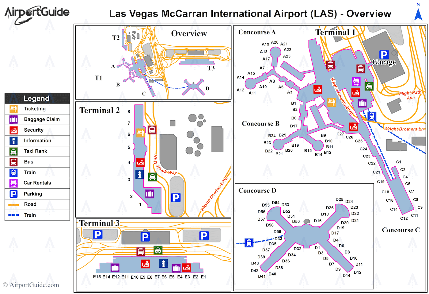
LAS Sectional
Flight Planning
at skyvector.com
at skyvector.com