Location
Latitude: |
35-09-16.6120N (35.154614) |
Longitude: |
114-33-33.5960W (-114.559332) |
Elevation: |
707.1 feet MSL (216 m MSL) |
Magnetic Variation: |
10.8 E (as of April 2024 from WMM2020 model) |
Time Zone: |
UTC -7.0 (Standard Time) UTC -7.0 (Daylight Savings Time) |
From City: |
01 N.M. N of Bullhead City, Arizona |
Found On: |
Phoenix Chart |
FAA Region: |
AWP |
Contacts
Manager: |
Publicly owned: |
| JAMES SCHELLER 2550 LAUGHLIN VIEW DR BULLHEAD CITY, AZ 86429 928-754-2134 X24 |
MOHAVE COUNTY BOX 390 KINGMAN, AZ 86402 |
Operations
Airport Status: |
Operational |
Facility Use: |
Public |
Type: |
Airport |
Control tower: |
Yes |
Attendance (Months/Days/Hours): |
Months/Days/Hours ALL/ALL/ALL |
Boundary ARTCC: |
ZLA (Los Angeles) |
Responsible ARTCC: |
ZLA (Los Angeles) |
Lighting Schedule: |
SEE RMK |
Segmented Circle Indicator: |
Yes |
Traffic Pattern Altitude (MSL): |
1707 feet (520 m) |
NOTAMs Facility: |
IFP |
NOTAM-D Service: |
Yes |
International Airport of Entry: |
No |
Customs Landing Rights: |
No |
Military Landing Rights: |
Yes |
Civil/Military Joint Use: |
No |
Aircraft Rescue and Firefighting: |
Class I ARFF Index: B Air Carrier Service: Scheduled Certification Date: 05/1973 |
Based Aircraft
| Single Engine: | 21 |
| Multi Engine: | 3 |
| GA Helicopters: | 4 |
Annual Operations (as of 01/01/2022)
| Total Operations: | 10085 | |
| Commercial: | 760 | 7.5% |
| Air Taxi: | 2147 | 21.3% |
| GA Local: | 1119 | 11.1% |
| GA Itinerant: | 5441 | 54.0% |
| Military Aircraft: | 618 | 6.1% |
Communications
| CTAF: | 123.900 |
| Tower: | BULLHEAD TOWER 123.9 Hrs: 0800-1800 |
| Ground: | 118.25 |
| Approach: | L.A. CENTER ARTCC |
| Departure: | L.A. CENTER ARTCC |
| ATIS: | 119.825 Hrs: 0800-1800 |
| AWOS-3PT: | 119.825 (928-754-4462) |
| ATIS BROADCASTS DURING TOWER HOURS OF OPERATION. AFTER TOWER HOURS OF OPERATION BROADCAST WILL REVERT TO AWOS-3PT USING THE SAME FREQUENCY. |
- APCH/DEP CTL SVC PRVDD BY LOS ANGELES ARTCC (ZLA) ON FREQS 134.65/360.65 (NELSON RCAG).
- ATCT CONTRACTED TO MIDWEST AIR TRAFFIC CONTROL SERVICES.
- LOS ANGELES ARTCC CLNC DEL 118.25 WHEN TOWER CLSD.
- ATIS BROADCASTS DURING TOWER HOURS OF OPERATION. AFTER TOWER HOURS OF OPERATION BROADCAST WILL REVERT TO AWOS-3PT USING THE SAME FREQUENCY.
Fixed Based Operators (FBOs) & Fuel
(Click on a business for detail)
Please help us keep this information up to date. This is a FREE SERVICE just like everything else on Airport Guide! If you see that a business needs to be added, modified, or deleted please fill out our Update Form.
To add, modify, or delete a business click here.
Please help us keep this information up to date. This is a FREE SERVICE just like everything else on Airport Guide! If you see that a business needs to be added, modified, or deleted please fill out our Update Form.
Area Code: 520 |
| Business Name | Frequency | Phone | Fuel Grade |
|---|---|---|---|
| Mojave County Airport Authority
Update FBO info |
Unicom 122.85 | 754-3922, -3020 | 100LL, Jet A |
| Sheble Aviation
Update FBO info |
754-8318 | ||
| Signature Flight Support
Update FBO info |
Unicom: 122.85 | +1 928 754 3020 |
Flight Service Stations
| Primary | Alternate | |
| FSS on Field: | N | |
| FSS Name (ID): | Prescott(PRC) | |
| Frequency: | ||
| Toll Free Phone: | 1-800-WX-BRIEF |
Instrument Procedures / Charts
FAA Terminal Procedures valid from 0901Z 03/21/24 to 0901Z 04/18/24.
There are various types of charts available for an airport. They are listed in the Page Type column. Here is a legend for those types:
APD - Airport Diagram
DP - Departure Procedure Charts
HOT - Hot Spots
IAP - Instrument Approach Procedure Charts
MIN - Minimums
STAR - Standard Terminal Arrival Charts
| Page Type | Page Name | Volume | Action Since Last Cycle |
|---|---|---|---|
| APD | AIRPORT DIAGRAM | SW-4 | |
| IAP | RNAV (GPS) RWY 16 | SW-4 | |
| IAP | RNAV (GPS) RWY 34 | SW-4 | |
| IAP | VOR RWY 34 | SW-4 | |
| MIN | ALTERNATE MINIMUMS | SW-4 | |
| MIN | TAKEOFF MINIMUMS | SW-4 |
Terminal Procedures are only available for airports in several countries with more being added all the time. If you are looking for a specific country's charts, please send an email to support(at)airportguide.com stating the country name. This will be used to prioritize the implementation.
Navigation Aids (Navaids) near IFP
| Dist (NM) | ID | Morse Code | Name | Type | Freq | True Hdg | Mag Hdg |
|---|---|---|---|---|---|---|---|
| 23.7 | EED | . . _ . . | Needles | VORTAC | 115.20 | 169 | 158 |
| 30.3 | GFS | _ _ . . . _ . . . . | Goffs | VORTAC | 114.40 | 267 | 256 |
| 31.3 | IGM | . . _ _ . _ _ | Kingman | VOR-DME | 108.80 | 78 | 67 |
| 52.6 | BLD | _ . . . . _ . . _ . . | Boulder City | VORTAC | 116.70 | 343 | 332 |
| 57.1 | PGS | . _ _ . _ _ . . . . | Peach Springs | VOR-DME | 112.00 | 60 | 49 |
| 62.8 | LAS | . _ . . . _ . . . | Las Vegas | VORTAC | 116.90 | 332 | 321 |
| 63.4 | PKE | . _ _ . _ . _ . | Parker | VORTAC | 117.90 | 185 | 174 |
| 63.7 | GOG | _ _ . _ _ _ _ _ . | Goodsprings | DME | 112.05 | 314 | 303 |
| 69.2 | LSV | . _ . . . . . . . . _ | Nellis | TACAN | 135.50 | 340 | 329 |
| 70.4 | VGT | . . . _ _ _ . _ | North Las Vegas | VOT | 108.20 | 334 | 323 |
| 86.5 | TNP | _ _ . . _ _ . | Twentynine Palms | VORTAC | 114.20 | 224 | 213 |
| 94.0 | BLH | _ . . . . _ . . . . . . | Blythe | VORTAC | 117.40 | 186 | 175 |
| 94.1 | NXP | _ . _ . . _ . _ _ . | Coyote | TACAN | 133.60 | 237 | 226 |
| 96.0 | HEC | . . . . . _ . _ . | Hector | VORTAC | 112.70 | 257 | 246 |
| 97.8 | MMM | _ _ _ _ _ _ | Mormon Mesa | VORTAC | 113.10 | 7 | 356 |
| 99.8 | DAG | _ . . . _ _ _ . | Daggett | VORTAC | 113.20 | 263 | 252 |
Nearby Airports with Fuel
Notices to Airmen (NOTAMS)
Remarks
| A110-1 | MTNS NW, NE, E AND SE. RISING TRRN N & S OF RWY ENDS. |
| A110-10 | NOISE SENSITIVE AREAS NE & SE. |
| A110-11 | SFC COND UNMNT 0600Z-1200Z. |
| A110-12 | TWY A5 BTN TWY A & GEN AVN APRON LTD TO WINGSPAN LESS THAN 79 FT. |
| A110-13 | RADAR SVC BLW 6000 FT NA. |
| A110-14 | GA LNDG FEE - 928-754-2134. |
| A110-7 | TPA FOR LIGHT ACFT 999 FT AGL, TPA FOR HIGH PERFORMANCE ACFT 1499 FT AGL. |
| A110-8 | TWY ALPHA 4 LTD TO WINGSPANS LESS THAN 79 FT. |
| A110-9 | CTN: LRG COML OPS AFT ATCT HRS; BIRDS ON & INVOF ARPT SEP-DEC. |
| A16 | 941-323-2178. |
| A17 | SVCS & FUEL 0600-2200 - 122.85; AFT HR NA. |
| A30A-16 | 66 FT PLINE PARL TO RWY 625 FT L 1300 FT FM RWY END. |
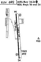
| A81-APT | ACTVT REIL RWY 16/34; MIRL RWY 16/34 - CTAF. |
| E111 | ESTABD PRIOR TO 1959. |
Runways
Runway Summary
| Runways: | 16/34 |
| Longest Runway: | 16/34 is 8501 ft (2591 m) long |
| Runways with an Instrument Approach: |
IFP Airport Runway Details
| Runway 16/34 | 8501 ft x 150 ft (2591 m x 46 m) | |
| Runway Length Source: | 3RD PARTY SURVEY as of 12/17/2016 | |
| Surface: | Asphalt - Good condition - Saw-cut or plastic grooved | |
| Runway Pavement Class: | 52 /F/A/X/T | |
| Runway Edge Lights: | Medium Intensity | |
Runway Weight Bearing Capacity (in thousands of pounds) |
||
| Single Wheel Landing Gear: | 75.0 | |
| Dual Wheel Landing Gear: | 200.0 | |
| Dual Tandem Wheel Landing Gear: | 400.0 | |
Runway 16 |
Runway 34 |
|
Elevation: |
625.5 | 707.1 |
Latitude: |
35-09-58.5653N | 35-08-34.6581N |
Longitude: |
114-33-36.7568W | 114-33-30.4358W |
|
Runway True Alignment: |
176 | 356 |
Glide Path Angle: |
3.0 degrees | 3.0 degrees |
Traffic Pattern: |
Right | |
Runway Markings Type: |
Nonprecision Instrument | Nonprecision Instrument |
Runway Markings Condition: |
Good | Good |
Object at End: |
POLE | |
Object Height: |
123 | |
Distance from End: |
3200 | |
Object Centerline Offset: |
550 ft. left of centerline | |
Visual Glide Slope Indicators: |
4-Light PAPI On Left Side Of Runway | 4-Light PAPI On Left Side Of Runway |
REIL: |
Yes | Yes |
Threshold Crossing Height: |
49 | 45 |
Declared Distances |
||
Take Off Run Avbl. (TORA): |
8500 | 8500 |
Take Off Distance Avbl. (TODA): |
8500 | 8500 |
Actual Stop Dist. Avbl. (ASDA): |
8500 | 8500 |
Landing Dist. Avbl. (LDA): |
8500 | 8500 |
Services
Airframe Repair: |
None |
Powerplant Repair: |
None |
Bottled Oxygen: |
None |
Bulk Oxygen: |
None |
Fuel Available: |
100LL, Jet A |
Landing Fees: |
No |
Parking: |
Hangars and tiedowns available |
Maps & Diagrams
IFP Sectional
Flight Planning
at skyvector.com
at skyvector.com