Location
Latitude: |
41-28-02.3000N (41.467306) |
Longitude: |
084-30-24.4000W (-84.506778) |
Elevation: |
729.6 feet MSL (222 m MSL) |
Magnetic Variation: |
6.4 W (as of April 2024 from WMM2020 model) |
Time Zone: |
UTC -5.0 (Standard Time) UTC -4.0 (Daylight Savings Time) |
From City: |
02 N.M. E of Bryan, Ohio |
Found On: |
Detroit Chart |
FAA Region: |
AGL |
Contacts
Manager: |
Publicly owned: |
| STEVE FORTNER 16288 COUNTY ROAD D, HANGAR C BRYAN, OH 43506-9802 419-630-4268 |
WILLIAMS COUNTY COMMISSIONERS 1 COURTHOUSE SQ, 4TH FLR BRYAN, OH 43506-1791 419-636-2059 |
Operations
Airport Status: |
Operational |
Facility Use: |
Public |
Type: |
Airport |
Activation Date: |
01/1961 |
Control tower: |
No |
Attendance (Months/Days/Hours): |
Months/Days/Hours APR-NOV/ALL/0800-1830 |
Boundary ARTCC: |
ZOB (Cleveland) |
Responsible ARTCC: |
ZOB (Cleveland) |
Lighting Schedule: |
SEE RMK |
Segmented Circle Indicator: |
No |
Traffic Pattern Altitude (MSL): |
1730 feet (527 m) |
NOTAMs Facility: |
CLE |
NOTAM-D Service: |
Yes |
International Airport of Entry: |
No |
Customs Landing Rights: |
No |
Military Landing Rights: |
No |
Civil/Military Joint Use: |
No |
Based Aircraft
| Single Engine: | 20 |
| Multi Engine: | 1 |
| Jet Engine: | 2 |
Annual Operations (as of 10/03/2023)
| Total Operations: | 8610 | |
| Air Taxi: | 8 | 0.1% |
| GA Local: | 6000 | 69.7% |
| GA Itinerant: | 2600 | 30.2% |
| Military Aircraft: | 2 | 0.0% |
Communications
| CTAF: | 122.800 |
| Unicom: | 122.800 |
| Approach: | TOLEDO 134.35 134.35 |
| Departure: | TOLEDO 134.35 134.35 |
Fixed Based Operators (FBOs) & Fuel
(Click on a business for detail)
Please help us keep this information up to date. This is a FREE SERVICE just like everything else on Airport Guide! If you see that a business needs to be added, modified, or deleted please fill out our Update Form.
To add, modify, or delete a business click here.
Please help us keep this information up to date. This is a FREE SERVICE just like everything else on Airport Guide! If you see that a business needs to be added, modified, or deleted please fill out our Update Form.
Area Code: 419 |
| Business Name | Frequency | Phone | Fuel Grade |
|---|---|---|---|
| Bryan Air Service
Update FBO info |
Unicom 122.8 | 636-1657 | 100LL, Jet A |
Flight Service Stations
| Primary | Alternate | |
| FSS on Field: | N | |
| FSS Name (ID): | Cleveland(CLE) | |
| Frequency: | ||
| Toll Free Phone: | 1-800-WX-BRIEF |
Instrument Procedures / Charts
FAA Terminal Procedures valid from 0901Z 03/21/24 to 0901Z 04/18/24.
There are various types of charts available for an airport. They are listed in the Page Type column. Here is a legend for those types:
APD - Airport Diagram
DP - Departure Procedure Charts
HOT - Hot Spots
IAP - Instrument Approach Procedure Charts
MIN - Minimums
STAR - Standard Terminal Arrival Charts
| Page Type | Page Name | Volume | Action Since Last Cycle |
|---|---|---|---|
| IAP | RNAV (GPS) RWY 07 | EC-2 | |
| IAP | RNAV (GPS) RWY 25 | EC-2 | |
| MIN | TAKEOFF MINIMUMS | EC-2 |
Terminal Procedures are only available for airports in several countries with more being added all the time. If you are looking for a specific country's charts, please send an email to support(at)airportguide.com stating the country name. This will be used to prioritize the implementation.
Navigation Aids (Navaids) near 0G6
| Dist (NM) | ID | Morse Code | Name | Type | Freq | True Hdg | Mag Hdg |
|---|---|---|---|---|---|---|---|
| 18.8 | USE | . . _ . . . . | Fulton | NDB | 375 | 63 | 70 |
| 21.9 | GW | _ _ . . _ _ | Shenk | NDB | 227 | 244 | 250 |
| 26.8 | TO | _ _ _ _ | Tophr | NDB | 219 | 78 | 85 |
| 28.0 | ANQ | . _ _ . _ _ . _ | Angola | NDB | 347 | 291 | 297 |
| 30.9 | ADG | . _ _ . . _ _ . | Adrian | NDB | 278 | 38 | 45 |
| 32.7 | TOL | _ _ _ _ . _ . . | Toledo | TACAN | 112.50 | 76 | 83 |
| 36.6 | VFU | . . . _ . . _ . . . _ | Stanley | NDB | 411 | 187 | 193 |
| 37.5 | LFD | . _ . . . . _ . _ . . | Litchfield | VOR-DME | 111.20 | 342 | 348 |
| 39.0 | VWV | . . . _ . _ _ . . . _ | Waterville | VOR-DME | 113.10 | 91 | 98 |
| 42.5 | FWA | . . _ . . _ _ . _ | Fort Wayne | VORTAC | 117.80 | 226 | 232 |
| 42.6 | FWA | . . _ . . _ _ . _ | Fort Wayne Baer | VOT | 111.00 | 226 | 232 |
| 43.9 | TCU | _ _ . _ . . . _ | Tecumseh | NDB | 239 | 39 | 46 |
| 45.7 | FBC | . . _ . _ . . . _ . _ . | Flag City | VORTAC | 108.20 | 131 | 138 |
| 46.3 | BNR | _ . . . _ . . _ . | Benton Ridge | NDB | 334 | 125 | 132 |
| 46.5 | IRS | . . . _ . . . . | Sturgis | NDB | 382 | 296 | 302 |
| 46.5 | OLK | _ _ _ . _ . . _ . _ | Webster Lake | VOR | 110.40 | 253 | 259 |
| 47.6 | JXN | . _ _ _ _ . . _ _ . | Jackson | DME | 115.45 | 2 | 8 |
| 51.4 | JX | . _ _ _ _ . . _ | Jakso | NDB | 212 | 6 | 13 |
| 51.7 | AOH | . _ _ _ _ . . . . | Allen County | VOR | 108.40 | 151 | 158 |
| 52.7 | FZI | . . _ . _ _ . . . . | Fostoria | NDB | 379 | 108 | 115 |
Nearby Airports with Fuel
Notices to Airmen (NOTAMS)
Remarks
| A110-2 | DEER, BIRDS, & WILDLIFE ON & INVOF ARPT. |
| A110-3 | FOR CD CTC TOLEDO APCH AT 419-865-1495. |
| A16 | OR 567-239-6664. |
| A57-07 | APCH SLP 20:1 TO DTHR OVR 40 FT LGTD POLE, 823 FT DIST, 254 FT R. |
| A57-25 | APCH SLP 16:1 TO DTHR OVR +77 FT TREE, 1291 FT DIST, 414 FT L. |
| A75 | PRIOR CDN RQRD. |
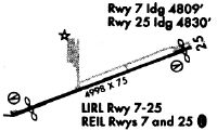
| A81-APT | ACTVT REIL RWY 07 & 25; MIRL RWY 07/25 - 123.0. |
Runways
Runway Summary
| Runways: | 07/25 |
| Longest Runway: | 07/25 is 4782 ft (1458 m) long |
| Runways with an Instrument Approach: |
0G6 Airport Runway Details
| Runway 07/25 | 4782 ft x 75 ft (1458 m x 23 m) | |
| Runway Length Source: | 3RD PARTY SURVEY as of 01/14/2010 | |
| Surface: | Asphalt - Good condition - Saw-cut or plastic grooved | |
| Runway Edge Lights: | Medium Intensity | |
Runway Weight Bearing Capacity (in thousands of pounds) |
||
| Single Wheel Landing Gear: | 30.0 | |
Runway 07 |
Runway 25 |
|
Elevation: |
729.4 | 729.6 |
Latitude: |
41-27-53.4984N | 41-28-11.0197N |
Longitude: |
084-30-53.5324W | 084-29-55.1958W |
|
Runway True Alignment: |
068 | 248 |
Glide Path Angle: |
3.0 degrees | 3.0 degrees |
Traffic Pattern: |
Left | |
Runway Markings Type: |
Nonprecision Instrument | Nonprecision Instrument |
Runway Markings Condition: |
Good | Good |
Object at End: |
ROAD | ROAD |
Object Height: |
16 | 16 |
Distance from End: |
330 | 320 |
Object Centerline Offset: |
275 ft. left of centerline | 265 ft. right of centerline |
Visual Glide Slope Indicators: |
4-Light PAPI On Left Side Of Runway | 4-Light PAPI On Left Side Of Runway |
REIL: |
Yes | Yes |
Touchdown Lights: |
No | No |
Centerline Lights: |
No | No |
Threshold Crossing Height: |
35 | 35 |
Threshold Elevation: |
729.5 | 729.5 |
Displaced Threshold: |
291 | 629 |
Threshold Latitude: |
41-27-54.5639N | 41-28-08.7141N |
Threshold Longitude: |
084-30-49.9860W | 084-30-02.8744W |
Services
Bottled Oxygen: |
None |
Bulk Oxygen: |
None |
Fuel Available: |
100LL, Jet A+ |
Landing Fees: |
No |
Parking: |
Hangars and tiedowns available |
Maps & Diagrams
0G6 Sectional
Flight Planning
at skyvector.com
at skyvector.com