Location
Latitude: |
41-42-35.6000N (41.709889) |
Longitude: |
092-44-09.5000W (-92.735972) |
Elevation: |
1008.4 feet MSL (307 m MSL) |
Magnetic Variation: |
0.3 W (as of May 2024 from WMM2020 model) |
Time Zone: |
UTC -6.0 (Standard Time) UTC -5.0 (Daylight Savings Time) |
From City: |
01 N.M. S of Grinnell, Iowa |
Found On: |
Chicago Chart |
FAA Region: |
ACE |
Contacts
Manager: |
Publicly owned: |
| RON LOWRY 1607 W ST S GRINNELL, IA 50112 641-236-0188 |
CITY OF GRINNELL CITY HALL 927 4TH AVE GRINNELL, IA 50112 641-236-2605 |
Operations
Airport Status: |
Operational |
Facility Use: |
Public |
Type: |
Airport |
Activation Date: |
11/1987 |
Control tower: |
No |
Attendance (Months/Days/Hours): |
Months/Days/Hours ALL/MON-FRI/0800-1700 |
Boundary ARTCC: |
ZAU (Chicago) |
Responsible ARTCC: |
ZAU (Chicago) |
Lighting Schedule: |
SEE RMK |
Segmented Circle Indicator: |
No |
Traffic Pattern Altitude (MSL): |
2008 feet (612 m) |
NOTAMs Facility: |
GGI |
NOTAM-D Service: |
Yes |
Based Aircraft
| Single Engine: | 17 |
| Jet Engine: | 1 |
| GA Helicopters: | 1 |
Annual Operations (as of 04/11/2022)
| Total Operations: | 5250 | |
| GA Local: | 3150 | 60.0% |
| GA Itinerant: | 2100 | 40.0% |
Communications
| CTAF: | 122.800 |
| Unicom: | 122.800 |
| AWOS-3: | 120.725 (641-236-9720) |
- APCH/DEP SVC PRVDD BY CHICAGO ARTCC ON FREQS 127.05/282.35 (DES MOINES RCAG).
Fixed Based Operators (FBOs) & Fuel
(Click on a business for detail)
Please help us keep this information up to date. This is a FREE SERVICE just like everything else on Airport Guide! If you see that a business needs to be added, modified, or deleted please fill out our Update Form.
To add, modify, or delete a business click here.
Please help us keep this information up to date. This is a FREE SERVICE just like everything else on Airport Guide! If you see that a business needs to be added, modified, or deleted please fill out our Update Form.
Area Code: 641 |
| Business Name | Frequency | Phone | Fuel Grade |
|---|---|---|---|
| Grinnell Aviation, Inc.
Update FBO info |
Unicom 122.8 | 236-8007 | 100LL, Jet A |
Flight Service Stations
| Primary | Alternate | |
| FSS on Field: | ||
| FSS Name (ID): | Fort Dodge(FOD) | |
| Frequency: | ||
| Toll Free Phone: | 1-800-WX-BRIEF |
Instrument Procedures / Charts
FAA Terminal Procedures valid from 0901Z 03/21/24 to 0901Z 04/18/24.
There are various types of charts available for an airport. They are listed in the Page Type column. Here is a legend for those types:
APD - Airport Diagram
DP - Departure Procedure Charts
HOT - Hot Spots
IAP - Instrument Approach Procedure Charts
MIN - Minimums
STAR - Standard Terminal Arrival Charts
| Page Type | Page Name | Volume | Action Since Last Cycle |
|---|---|---|---|
| IAP | RNAV (GPS) RWY 13 | NC-3 | |
| IAP | RNAV (GPS) RWY 31 | NC-3 | |
| IAP | VOR/DME RWY 31 | NC-3 | |
| MIN | ALTERNATE MINIMUMS | NC-3 | |
| MIN | TAKEOFF MINIMUMS | NC-3 |
Terminal Procedures are only available for airports in several countries with more being added all the time. If you are looking for a specific country's charts, please send an email to support(at)airportguide.com stating the country name. This will be used to prioritize the implementation.
Navigation Aids (Navaids) near KGGI
| Dist (NM) | ID | Morse Code | Name | Type | Freq | True Hdg | Mag Hdg |
|---|---|---|---|---|---|---|---|
| 17.3 | TNU | _ _ . . . _ | Newton | VOR-DME | 112.50 | 285 | 285 |
| 20.6 | PEA | . _ _ . . . _ | Pella | NDB | 257 | 207 | 207 |
| 25.3 | JWJ | . _ _ _ . _ _ . _ _ _ | Elmwood | DME | 109.4 | 342 | 342 |
| 31.1 | OOA | _ _ _ _ _ _ . _ | Oskaloosa | NDB | 414 | 158 | 158 |
| 42.6 | DSM | _ . . . . . _ _ | Des Moines | VOT | 109.20 | 256 | 256 |
| 42.9 | EE | . . | Merle | NDB | 362 | 285 | 285 |
| 43.8 | CID | _ . _ . . . _ . . | Cedar Rapids | VOR-DME | 114.10 | 75 | 76 |
| 44.1 | DSM | _ . . . . . _ _ | Des Moines | VORTAC | 117.50 | 248 | 248 |
| 44.8 | OTM | _ _ _ _ _ _ | Ottumwa | VOR-DME | 111.60 | 155 | 155 |
| 51.6 | IOW | . . _ _ _ . _ _ | Iowa City | VOR-DME | 116.20 | 102 | 103 |
| 53.0 | ALO | . _ . _ . . _ _ _ | Waterloo | VOR-DME | 112.20 | 16 | 16 |
| 53.8 | FFL | . . _ . . . _ . . _ . . | Fairfield | NDB | 332 | 140 | 141 |
| 54.3 | AWG | . _ . _ _ _ _ . | Washington | NDB | 219 | 118 | 119 |
| 56.7 | IIB | . . . . _ . . . | Wapsie | NDB | 206 | 37 | 38 |
| 59.5 | BEX | _ . . . . _ . . _ | Bloomfield | NDB | 269 | 166 | 166 |
| 66.9 | EBS | . _ . . . . . . | Webster City | NDB | 323 | 311 | 311 |
| 71.5 | MPZ | _ _ . _ _ . _ _ . . | Mount Pleasant | NDB | 212 | 129 | 130 |
| 74.1 | EFW | . . . _ . . _ _ | Jefferson | NDB | 391 | 284 | 284 |
| 74.2 | DDD | _ . . _ . . _ . . | Port City | DME | 116.5 | 105 | 106 |
| 77.0 | CAV | _ . _ . . _ . . . _ | Clarion | NDB | 387 | 324 | 324 |
Nearby Airports with Fuel
Notices to Airmen (NOTAMS)
Remarks
| A110-1 | RY 31 IS CALM WIND RY. |
| A110-2 | FOR CD IF UNA TO CTC ON FSS FREQ, CTC CHICAGO ARTCC AT 630-906-8921. |
| A57-13 | RWY 13 APCH SLP 35:1 TO DSPLCD THR. |
| A57-31 | RWY 31 APCH SLP 25:1 TO DSPLCD THR. |
| A70-FUEL-10 | 0LL FOR FUEL AFT HRS CALL (641) 236-0188. |
| A81-APT | MIRL RWY 13/31 PRESET ON LOW INTST; TO INCR INTST & ACTVT PAPI & REIL RWYS 13 & 31- CTAF. |
| E111 | AIRSPACE DETERMINATION PENDING. |
Runways
Runway Summary
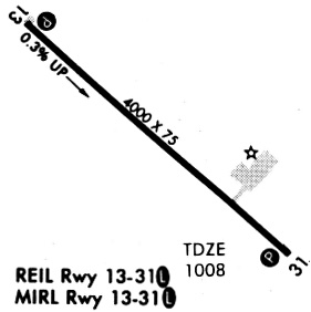
| Runways: | 13/31 |
| Longest Runway: | 13/31 is 5200 ft (1585 m) long |
| Runways with an Instrument Approach: |
KGGI Airport Runway Details
| Runway 13/31 | 5200 ft x 75 ft (1585 m x 23 m) | |
| Runway Length Source: | 3RD PARTY SURVEY as of 09/22/2011 | |
| Surface: | Concrete - Excellent condition - Saw-cut or plastic grooved | |
| Runway Pavement Class: | 12 /R/C/W/U | |
| Runway Edge Lights: | Medium Intensity | |
Runway Weight Bearing Capacity (in thousands of pounds) |
||
| Single Wheel Landing Gear: | 30.0 | |
| Dual Wheel Landing Gear: | 30.0 | |
Runway 13 |
Runway 31 |
|
Elevation: |
988.8 | 1007.8 |
Latitude: |
41-42-52.4872N | 41-42-18.7624N |
Longitude: |
092-44-35.3887W | 092-43-43.6740W |
|
Runway True Alignment: |
131 | 311 |
Glide Path Angle: |
3.0 degrees | 3.0 degrees |
Runway Markings Type: |
Nonprecision Instrument | Nonprecision Instrument |
Runway Markings Condition: |
Good | Good |
Object at End: |
TREE | TREE |
Object Height: |
40 | 52 |
Distance from End: |
1230 | 1109 |
Object Centerline Offset: |
53 ft. left of centerline | 84 ft. left of centerline |
Visual Glide Slope Indicators: |
2-Light PAPI On Left Side Of Runway | 2-Light PAPI On Left Side Of Runway |
REIL: |
Yes | Yes |
Threshold Crossing Height: |
40 | 40 |
Threshold Elevation: |
990.0 | 1007.9 |
Displaced Threshold: |
200 | 200 |
Threshold Latitude: |
41-42-51.1906N | 41-42-20.0581N |
Threshold Longitude: |
092-44-33.4017W | 092-43-45.6627W |
Services
Airframe Repair: |
Major |
Powerplant Repair: |
Major |
Bottled Oxygen: |
None |
Bulk Oxygen: |
None |
Fuel Available: |
100LL |
Landing Fees: |
No |
Parking: |
Hangars and tiedowns available |
Maps & Diagrams
KGGI Sectional
Flight Planning
at skyvector.com
at skyvector.com