Location
Latitude: |
34-24-11.1000N (34.403083) |
Longitude: |
080-07-09.2000W (-80.119222) |
Elevation: |
363.5 feet MSL (111 m MSL) |
Magnetic Variation: |
8.3 W (as of April 2024 from WMM2020 model) |
Time Zone: |
UTC -5.0 (Standard Time) UTC -4.0 (Daylight Savings Time) |
From City: |
03 N.M. NW of Hartsville, South Carolina |
Found On: |
Charlotte Chart |
FAA Region: |
ASO |
Contacts
Manager: |
Publicly owned: |
| MARK DEFIELDS 1083 HARTSVILLE AIRPORT ROAD HARTSVILLE, SC 29550 910-284-3166 |
CITY OF HARTSVILLE PO BOX 2497 HARTSVILLE, SC 29550 843-383-3007 |
Operations
Airport Status: |
Operational |
Facility Use: |
Public |
Type: |
Airport |
Activation Date: |
04/1959 |
Control tower: |
No |
Attendance (Months/Days/Hours): |
Months/Days/Hours ALL/ALL/0800-1700 |
Boundary ARTCC: |
ZJX (Jacksonville) |
Responsible ARTCC: |
ZJX (Jacksonville) |
Lighting Schedule: |
SEE RMK |
Segmented Circle Indicator: |
Yes |
Traffic Pattern Altitude (MSL): |
1364 feet (416 m) |
NOTAMs Facility: |
AND |
NOTAM-D Service: |
Yes |
International Airport of Entry: |
No |
Customs Landing Rights: |
No |
Military Landing Rights: |
Yes |
Civil/Military Joint Use: |
No |
Based Aircraft
| Single Engine: | 13 |
| Multi Engine: | 1 |
Annual Operations (as of 06/16/2021)
| Total Operations: | 5300 | |
| Air Taxi: | 205 | 3.9% |
| GA Local: | 3053 | 57.6% |
| GA Itinerant: | 1742 | 32.9% |
| Military Aircraft: | 300 | 5.7% |
Communications
| CTAF: | 122.800 |
| Unicom: | 122.800 |
| Approach: | SHAW 125.4 125.4 JAX ARTCC |
| Departure: | SHAW 125.4 125.4 JAX ARTCC |
| AWOS-3: | 118.225 (843-339-9625) |
- APCH/DEP SVC PRVDD BY JACKSONVILLE ARTCC ON FREQS 124.7/269.55 (COLUMBIA RCAG) WHEN SHAW APCH CTL CLSD.
Fixed Based Operators (FBOs) & Fuel
(Click on a business for detail)
Please help us keep this information up to date. This is a FREE SERVICE just like everything else on Airport Guide! If you see that a business needs to be added, modified, or deleted please fill out our Update Form.
To add, modify, or delete a business click here.
Please help us keep this information up to date. This is a FREE SERVICE just like everything else on Airport Guide! If you see that a business needs to be added, modified, or deleted please fill out our Update Form.
Area Code: 843 |
| Business Name | Frequency | Phone | Fuel Grade |
|---|---|---|---|
| Horton Aviation
Update FBO info |
383-5571 | 100LL, Jet A |
Flight Service Stations
| Primary | Alternate | |
| FSS on Field: | N | |
| FSS Name (ID): | Anderson(AND) | |
| Frequency: | ||
| Toll Free Phone: | 1-800-WX-BRIEF |
Instrument Procedures / Charts
FAA Terminal Procedures valid from 0901Z 03/21/24 to 0901Z 04/18/24.
There are various types of charts available for an airport. They are listed in the Page Type column. Here is a legend for those types:
APD - Airport Diagram
DP - Departure Procedure Charts
HOT - Hot Spots
IAP - Instrument Approach Procedure Charts
MIN - Minimums
STAR - Standard Terminal Arrival Charts
| Page Type | Page Name | Volume | Action Since Last Cycle |
|---|---|---|---|
| IAP | RNAV (GPS) RWY 03 | SE-2 | |
| IAP | RNAV (GPS) RWY 21 | SE-2 | |
| IAP | VOR-A | SE-2 | |
| MIN | TAKEOFF MINIMUMS | SE-2 |
Terminal Procedures are only available for airports in several countries with more being added all the time. If you are looking for a specific country's charts, please send an email to support(at)airportguide.com stating the country name. This will be used to prioritize the implementation.
Navigation Aids (Navaids) near HVS
| Dist (NM) | ID | Morse Code | Name | Type | Freq | True Hdg | Mag Hdg |
|---|---|---|---|---|---|---|---|
| 0.2 | HVS | . . . . . . . _ . . . | Hartsville | NDB | 341 | 352 | 360 |
| 11.7 | UDG | . . _ _ . . _ _ . | Darlington | NDB | 245 | 78 | 86 |
| 16.7 | CTF | _ . _ . _ . . _ . | Chesterfield | VOR-DME | 114.55 | 332 | 340 |
| 19.1 | FL | . . _ . . _ . . | Alcot | NDB | 335 | 136 | 144 |
| 23.1 | BES | _ . . . . . . . | Bennettsville | NDB | 230 | 55 | 63 |
| 23.2 | PYG | . _ _ . _ . _ _ _ _ . | Pageland | NDB | 270 | 332 | 340 |
| 23.9 | CQW | _ . _ . _ _ . _ . _ _ | Cheraw | NDB | 409 | 31 | 39 |
| 25.1 | FLO | . . _ . . _ . . _ _ _ | Florence | VORTAC | 115.20 | 113 | 121 |
| 27.5 | SMS | . . . _ _ . . . | Sumter | NDB | 252 | 205 | 213 |
| 30.8 | SSC | . . . . . . _ . _ . | Shaw | TACAN | 110.10 | 214 | 222 |
| 37.2 | CFY | _ . _ . . . _ . _ . _ _ | Evans | NDB | 420 | 151 | 159 |
| 37.2 | DLC | _ . . . _ . . _ . _ . | Dillon | NDB | 274 | 85 | 94 |
| 38.8 | ME | _ _ . | Maxtn | NDB | 257 | 59 | 68 |
| 41.1 | MAO | _ _ . _ _ _ _ | Marion | NDB | 388 | 108 | 117 |
| 41.3 | LKR | . _ . . _ . _ . _ . | Lancaster | NDB | 400 | 297 | 305 |
| 43.2 | CKI | _ . _ . _ . _ . . | Kingstree | NDB | 404 | 162 | 170 |
| 43.9 | TWL | _ . _ _ . _ . . | Wesley | NDB | 204 | 318 | 326 |
| 44.5 | MMT | _ _ _ _ _ | Mc Entire | VORTAC | 113.20 | 229 | 237 |
| 48.8 | HFF | . . . . . . _ . . . _ . | Mackall | NDB | 278 | 39 | 48 |
| 49.1 | MNI | _ _ _ . . . | Manning | NDB | 381 | 185 | 193 |
Nearby Airports with Fuel
Notices to Airmen (NOTAMS)
Remarks
| A110-1 | +300 FT ANT 2.5 MI SW OF ARPT. |
| A110-2 | FOR CD CTC SHAW APCH AT 803-895-4884, WHEN APCH CLSD CTC JACKSONVILLE ARTCC AT 904-845-1592. |
| A14 | CELL: 910-284-3166 |
| A58-21 | 10 FT TALL TREE 230 FT R OF RWY 21 CENTERLINE, 48 FT FM RWY END. |
| A81-APT | ACTVT PAPI RWY 03 & 21 - CTAF. MIRL RWY 03/21 PRESET LOW INTST DUSK-2100; TO INCR INTST AND ACTVT MIRL 03/21 AFTER 2100 - CTAF. |
Runways
Runway Summary
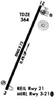
| Runways: | 03/21 |
| Longest Runway: | 03/21 is 5000 ft (1524 m) long |
| Runways with an Instrument Approach: |
HVS Airport Runway Details
| Runway 03/21 | 5000 ft x 75 ft (1524 m x 23 m) | |
| Runway Length Source: | 3RD PARTY SURVEY as of 09/24/2011 | |
| Surface: | Asphalt - Fair condition - No special surface treatment | |
| Runway Pavement Class: | 5 /F/C/Y/T | |
| Runway Edge Lights: | Medium Intensity | |
Runway Weight Bearing Capacity (in thousands of pounds) |
||
| Single Wheel Landing Gear: | 16.0 | |
| Dual Wheel Landing Gear: | 25.5 | |
Runway 03 |
Runway 21 |
|
Elevation: |
342.3 | 363.5 |
Latitude: |
34-23-48.2067N | 34-24-33.9246N |
Longitude: |
080-07-20.5929W | 080-06-57.8354W |
|
Runway True Alignment: |
022 | 202 |
Glide Path Angle: |
3.0 degrees | 3.0 degrees |
Traffic Pattern: |
Right | Left |
Runway Markings Type: |
Nonprecision Instrument | Nonprecision Instrument |
Runway Markings Condition: |
Good | Good |
Object at End: |
TREE | |
Object Height: |
24 | |
Distance from End: |
679 | |
Object Centerline Offset: |
248 ft. left of centerline | |
Visual Glide Slope Indicators: |
2-Light PAPI On Left Side Of Runway | 2-Light PAPI On Left Side Of Runway |
REIL: |
No | |
Threshold Crossing Height: |
28 | 23 |
Services
Airframe Repair: |
Major |
Powerplant Repair: |
Major |
Bottled Oxygen: |
None |
Bulk Oxygen: |
None |
Fuel Available: |
100LL |
Landing Fees: |
No |
Parking: |
Tiedowns available |
Maps & Diagrams
HVS Sectional
Flight Planning
at skyvector.com
at skyvector.com