Location
Latitude: |
40-26-14.7000N (40.437417) |
Longitude: |
104-37-59.6000W (-104.633222) |
Elevation: |
4696.8 feet MSL (1432 m MSL) |
Magnetic Variation: |
7.5 E (as of April 2024 from WMM2020 model) |
Time Zone: |
UTC -7.0 (Standard Time) UTC -6.0 (Daylight Savings Time) |
From City: |
03 N.M. E of Greeley, Colorado |
Found On: |
Cheyenne Chart |
FAA Region: |
ANM |
Contacts
Manager: |
Publicly owned: |
| COOPER ANDERSON PO BOX 727 GREELEY, CO 80632 (970) 336-3001 |
GREELEY-WELD CO ARPT AUTH PO BOX 727 GREELEY, CO 80632 970-336-3000 |
Operations
Airport Status: |
Operational |
Facility Use: |
Public |
Type: |
Airport |
Activation Date: |
10/1944 |
Control tower: |
No |
Attendance (Months/Days/Hours): |
Months/Days/Hours ALL/ALL/0600-1900 |
Boundary ARTCC: |
ZDV (Denver) |
Responsible ARTCC: |
ZDV (Denver) |
Lighting Schedule: |
SEE RMK |
Segmented Circle Indicator: |
Yes |
Traffic Pattern Altitude (MSL): |
5697 feet (1736 m) |
NOTAMs Facility: |
GXY |
NOTAM-D Service: |
Yes |
International Airport of Entry: |
No |
Customs Landing Rights: |
No |
Military Landing Rights: |
Yes |
Civil/Military Joint Use: |
No |
Based Aircraft
| Single Engine: | 125 |
| Multi Engine: | 16 |
| Jet Engine: | 6 |
| GA Helicopters: | 3 |
Annual Operations (as of 12/31/2018)
| Total Operations: | 110660 | |
| GA Local: | 66096 | 59.7% |
| GA Itinerant: | 44064 | 39.8% |
| Military Aircraft: | 500 | 0.5% |
Communications
| CTAF: | 122.800 |
| Unicom: | 122.800 |
| Approach: | DENVER |
| Departure: | DENVER |
| AWOS-3PT: | 135.175 (970-352-3511) |
- COMMUNICATIONS PRVDD BY DENVER RADIO ON FREQ 122.5 (GILL RCO).
Fixed Based Operators (FBOs) & Fuel
(Click on a business for detail)
Please help us keep this information up to date. This is a FREE SERVICE just like everything else on Airport Guide! If you see that a business needs to be added, modified, or deleted please fill out our Update Form.
To add, modify, or delete a business click here.
Please help us keep this information up to date. This is a FREE SERVICE just like everything else on Airport Guide! If you see that a business needs to be added, modified, or deleted please fill out our Update Form.
Area Code: 970 |
| Business Name | Frequency | Phone | Fuel Grade |
|---|---|---|---|
| AIMS Flight Training Center
Update FBO info |
800-677-AIMS (2467) | ||
| Beegles Aircraft Service, Inc.
Update FBO info |
353-9200 | ||
| Blue Sky Flyers
Website Update FBO info |
330-0530 | ||
| Greeley-Weld County Airport Authority
Website Update FBO info |
336-3000 | ||
| Greeley-Weld Jet Center
Update FBO info |
122.80 | 336-3010 | 100LL, Jet A |
| Harris Aviation Services
Website Update FBO info |
356-6041 | ||
| Harris Jet Center
Website Update FBO info |
122.85 | 351-8957 | 100LL, Jet A |

|
Phillips | 100LL - 2.25 USD per gallon on 7/19/01 |
Volume discounts on fuel |
|
|
Phillips | Jet A - 1.90 USD per gallon on 7/19/01 |
Volume discounts on fuel |
| Low Level Dusting
Update FBO info |
356-5654 | ||
| Meridian Aircraft Company
Update FBO info |
372-9204 | ||
| Precision Propeller Service, Inc.
Update FBO info |
800-352-8578 |
Flight Service Stations
| Primary | Alternate | |
| FSS on Field: | N | |
| FSS Name (ID): | Denver(DEN) | |
| Frequency: | ||
| Toll Free Phone: | 1-800-WX-BRIEF |
Instrument Procedures / Charts
FAA Terminal Procedures valid from 0901Z 03/21/24 to 0901Z 04/18/24.
There are various types of charts available for an airport. They are listed in the Page Type column. Here is a legend for those types:
APD - Airport Diagram
DP - Departure Procedure Charts
HOT - Hot Spots
IAP - Instrument Approach Procedure Charts
MIN - Minimums
STAR - Standard Terminal Arrival Charts
Terminal Procedures are only available for airports in several countries with more being added all the time. If you are looking for a specific country's charts, please send an email to support(at)airportguide.com stating the country name. This will be used to prioritize the implementation.
Navigation Aids (Navaids) near GXY
| Dist (NM) | ID | Morse Code | Name | Type | Freq | True Hdg | Mag Hdg |
|---|---|---|---|---|---|---|---|
| 5.4 | GLL | _ _ . . _ . . . _ . . | Gill | VOR-DME | 114.20 | 42 | 35 |
| 6.2 | DC | _ . . _ . _ . | Buffs | NDB | 348 | 176 | 169 |
| 16.1 | FN | . . _ . _ . | Colln | NDB | 400 | 254 | 246 |
| 32.6 | DVV | _ . . . . . _ . . . _ | Mile High | VORTAC | 114.70 | 179 | 172 |
| 34.0 | DEN | _ . . . _ . | Denver | VOT | 110.00 | 181 | 174 |
| 37.5 | DEN | _ . . . _ . | Denver | VOR-DME | 117.90 | 181 | 174 |
| 39.1 | BJC | _ . . . . _ _ _ _ . _ . | Jeffco | VOR-DME | 115.40 | 216 | 208 |
| 39.8 | FT | . . _ . _ | Skipi | NDB | 321 | 166 | 159 |
| 44.1 | BKF | _ . . . _ . _ . . _ . | Buckley | TACAN | 109.60 | 187 | 180 |
| 44.8 | FQF | . . _ . _ _ . _ . . _ . | Falcon | VORTAC | 116.30 | 179 | 172 |
| 46.8 | CYS | _ . _ . _ . _ _ . . . | Cheyenne | VORTAC | 113.10 | 352 | 344 |
| 52.6 | APA | . _ . _ _ . . _ | Centennial | VOT | 108.20 | 190 | 182 |
| 59.9 | AP | . _ . _ _ . | Casse | NDB | 260 | 189 | 181 |
| 64.3 | BAJ | _ . . . . _ . _ _ _ | Batten | NDB | 392 | 84 | 77 |
| 68.6 | AKO | . _ _ . _ _ _ _ | Akron | VOR-DME | 114.40 | 103 | 96 |
| 73.2 | LAR | . _ . . . _ . _ . | Laramie | VOR-DME | 117.60 | 317 | 309 |
| 78.8 | TXC | _ _ . . _ _ . _ . | Thurman | VORTAC | 112.90 | 123 | 116 |
| 84.8 | SNY | . . . _ . _ . _ _ | Sidney | VOR-DME | 115.90 | 61 | 54 |
| 86.9 | RLG | . _ . . _ . . _ _ . | Kremmling | VOR-DME | 113.80 | 253 | 245 |
| 89.6 | BRK | _ . . . . _ . _ . _ | Black Forest | VOR-DME | 112.50 | 180 | 173 |
Nearby Airports with Fuel
Notices to Airmen (NOTAMS)
Remarks
| A110*G | THIS AIRPORT HAS BEEN SURVEYED BY THE NATIONAL GEODETIC SURVEY. |
| A110-1 | RY 17/35 PREFERRED USE WHEN CROSS WIND COMPONENT EXCEEDS 12 KT ON RY 10/28. |
| A110-2 | RWY 35 PREFERRED USE WHEN WIND LESS THAN 5 KNOTS. RY 35 PREFERRED FOR TGL. |
| A110-3 | WILDLIFE AND BRIDS ON & INVOF APRT. |
| A110-4 | OIL DRILLING RIGS UP TO 120 FT AGL ON AND INVICINTY OF AIRPORT. |
| A110-5 | BE ALERT; INTENSIVE USAF STUDENT TRAINING IN VICINITY OF COLORADO SPRINGS & PUEBLO COLORADO. |
| A110-6 | ACFT DEPG RWY28 AVOID SB TURN PRIOR TO XNG RWY10 THLD. |
| A17 | PREARRANGE AFTER HOURS AIRPORT ACCESS WITH FBO'S. CALL 970-336-4866 OR 970-351-8957. |
| A17 1 | FOR ATTENDANCE AFT HRS CALL 970-336-3010 |
| A58-10 | +10 FT DIRT ACCESS ROAD AT THLD & PARALLEL TO EXTDD CNTRLN; +9 FT CROPS 140 FT FM THLD 90 FT L & R OF CNTRLN. |
| A81-APT | ACTVT MIRL RYS 10/28 & 17/35, & REIL RYS 10, 28, 17, & 35 - CTAF. PAPI RYS 10, 17, 35, & VASI RY 28 OPR 24 HRS. |
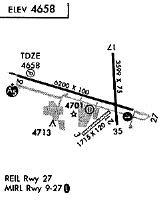
Runways
Runway Summary
| Runways: | 10/28 17/35 H1 H2 |
| Longest Runway: | 17/35 is 10000 ft (3048 m) long |
| Runways with an Instrument Approach: | 35 |
GXY Airport Runway Details
| Runway 10/28 | 5801 ft x 100 ft (1768 m x 30 m) | |
| Runway Length Source: | NGS as of 09/23/2004 | |
| Surface: | Asphalt - Good condition - No special surface treatment | |
| Runway Edge Lights: | Medium Intensity | |
Runway Weight Bearing Capacity (in thousands of pounds) |
||
| Single Wheel Landing Gear: | 18.0 | |
| Dual Wheel Landing Gear: | 30.0 | |
Runway 10 |
Runway 28 |
|
Elevation: |
4661.2 | 4644.8 |
Latitude: |
40-25-50.4739N | 40-25-35.2348N |
Longitude: |
104-38-46.0187W | 104-37-33.7247W |
|
Runway True Alignment: |
105 | 285 |
Glide Path Angle: |
3.0 degrees | 3.0 degrees |
Traffic Pattern: |
Left | Right |
Runway Markings Type: |
Precision Instrument | Precision Instrument |
Runway Markings Condition: |
Good | Good |
Object at End: |
POLE | |
Object Height: |
27 | |
Distance from End: |
1485 | |
Object Centerline Offset: |
144 ft. left of centerline | |
Visual Glide Slope Indicators: |
2-Light PAPI On Left Side Of Runway | 4-Box VASI On Left Side Of Runway |
REIL: |
Yes | Yes |
Threshold Crossing Height: |
43 | 27 |
| Runway 17/35 | 10000 ft x 100 ft (3048 m x 30 m) | |
| Runway Length Source: | NGS as of 09/23/2004 | |
| Surface: | Asphalt - Good condition - No special surface treatment | |
| Runway Edge Lights: | Medium Intensity | |
Runway Weight Bearing Capacity (in thousands of pounds) |
||
| Single Wheel Landing Gear: | 30.0 | |
| Dual Wheel Landing Gear: | 45.0 | |
Runway 17 |
Runway 35 |
|
Elevation: |
4696.8 | 4648.5 |
Latitude: |
40-27-22.4976N | 40-25-43.7742N |
Longitude: |
104-37-56.0528W | 104-37-51.1063W |
|
Runway True Alignment: |
177 | 357 |
ILS Type: |
ILS/DME | |
Glide Path Angle: |
3.0 degrees | 3.0 degrees |
Traffic Pattern: |
Left | |
Runway Markings Type: |
Precision Instrument | Precision Instrument |
Runway Markings Condition: |
Good | Good |
Object at End: |
TREE | |
Object Height: |
56 | |
Distance from End: |
2834 | |
Object Centerline Offset: |
144 ft. left of centerline | |
Visual Glide Slope Indicators: |
2-Light PAPI On Left Side Of Runway | 2-Light PAPI On Left Side Of Runway |
REIL: |
Yes | Yes |
Threshold Crossing Height: |
46 | 51 |
Threshold Elevation: |
4652.9 | |
Displaced Threshold: |
1100 | |
Threshold Latitude: |
40-25-54.6369N | |
Threshold Longitude: |
104-37-51.6467W |
| Helipad H1 | 20 ft x 20 ft (6 m x 6 m) | |
| Surface: | Asphalt - Good condition - No special surface treatment | |
Helipad H1 |
||
Glide Path Angle: |
0.0 degrees | 0.0 degrees |
Object Centerline Offset: |
144 ft. left of centerline |
| Helipad H2 | 20 ft x 20 ft (6 m x 6 m) | |
| Runway Length Source: | STATE as of 03/18/2004 | |
| Surface: | Asphalt - Good condition - No special surface treatment | |
Helipad H2 |
||
Glide Path Angle: |
0.0 degrees | 0.0 degrees |
Object Centerline Offset: |
144 ft. left of centerline |
Services
Airframe Repair: |
Minor |
Powerplant Repair: |
Minor |
Fuel Available: |
100LL |
Landing Fees: |
No |
Parking: |
Tiedowns available |
Maps & Diagrams
GXY Sectional
Flight Planning
at skyvector.com
at skyvector.com