Location
Latitude: |
40-36-51.4730N (40.614298) |
Longitude: |
103-15-51.3400W (-103.264261) |
Elevation: |
4037.6 feet MSL (1231 m MSL) |
Magnetic Variation: |
6.8 E (as of April 2024 from WMM2020 model) |
Time Zone: |
UTC -7.0 (Standard Time) UTC -6.0 (Daylight Savings Time) |
From City: |
03 N.M. W of Sterling, Colorado |
Found On: |
Cheyenne Chart |
FAA Region: |
ANM |
Contacts
Manager: |
Publicly owned: |
| CHARLIE MAY 16562 HWY 14 STERLING, CO 80751 970-522-0417 |
CITY OF STERLING P. O. BOX 4000 STERLING, CO 80751 970-522-9700 |
Operations
Airport Status: |
Operational |
Facility Use: |
Public |
Type: |
Airport |
Activation Date: |
04/1940 |
Control tower: |
No |
Attendance (Months/Days/Hours): |
Months/Days/Hours ALL/ALL/0700-1600 |
Boundary ARTCC: |
ZDV (Denver) |
Responsible ARTCC: |
ZDV (Denver) |
Lighting Schedule: |
SEE RMK |
Segmented Circle Indicator: |
Yes |
Traffic Pattern Altitude (MSL): |
5038 feet (1536 m) |
NOTAMs Facility: |
DEN |
NOTAM-D Service: |
Yes |
International Airport of Entry: |
No |
Customs Landing Rights: |
No |
Military Landing Rights: |
Yes |
Civil/Military Joint Use: |
No |
Based Aircraft
| Single Engine: | 19 |
| Multi Engine: | 3 |
| Jet Engine: | 1 |
| GA Helicopters: | 1 |
Annual Operations (as of 12/31/2019)
| Total Operations: | 2413 | |
| Air Taxi: | 116 | 4.8% |
| GA Local: | 1132 | 46.9% |
| GA Itinerant: | 1121 | 46.5% |
| Military Aircraft: | 44 | 1.8% |
Communications
| CTAF: | 122.800 |
| Unicom: | 122.800 |
| AWOS-3: | 118.525 (970-526-3009) |
- APCH/DEP CTL SVC PRVDD BY DENVER (ZDV) ON FREQS 118.475/225.4 (BRUSH/B/ RCAG).
Fixed Based Operators (FBOs) & Fuel
(Click on a business for detail)
Please help us keep this information up to date. This is a FREE SERVICE just like everything else on Airport Guide! If you see that a business needs to be added, modified, or deleted please fill out our Update Form.
To add, modify, or delete a business click here.
Please help us keep this information up to date. This is a FREE SERVICE just like everything else on Airport Guide! If you see that a business needs to be added, modified, or deleted please fill out our Update Form.
Area Code: 970 |
| Business Name | Frequency | Phone | Fuel Grade |
|---|---|---|---|
| Sterling Municipal Airport
Update FBO info |
Unicom 122.8 | 522-0417, after hours call 520-2325 | 100LL, Jet A |
Flight Service Stations
| Primary | Alternate | |
| FSS on Field: | N | |
| FSS Name (ID): | Denver(DEN) | |
| Frequency: | ||
| Toll Free Phone: | 1-800-WX-BRIEF |
Instrument Procedures / Charts
FAA Terminal Procedures valid from 0901Z 03/21/24 to 0901Z 04/18/24.
There are various types of charts available for an airport. They are listed in the Page Type column. Here is a legend for those types:
APD - Airport Diagram
DP - Departure Procedure Charts
HOT - Hot Spots
IAP - Instrument Approach Procedure Charts
MIN - Minimums
STAR - Standard Terminal Arrival Charts
| Page Type | Page Name | Volume | Action Since Last Cycle |
|---|---|---|---|
| IAP | RNAV (GPS) RWY 15 | SW-1 | |
| IAP | RNAV (GPS) RWY 33 | SW-1 | |
| MIN | ALTERNATE MINIMUMS | SW-1 | |
| MIN | TAKEOFF MINIMUMS | SW-1 |
Terminal Procedures are only available for airports in several countries with more being added all the time. If you are looking for a specific country's charts, please send an email to support(at)airportguide.com stating the country name. This will be used to prioritize the implementation.
Navigation Aids (Navaids) near STK
| Dist (NM) | ID | Morse Code | Name | Type | Freq | True Hdg | Mag Hdg |
|---|---|---|---|---|---|---|---|
| 5.2 | BAJ | _ . . . . _ . _ _ _ | Batten | NDB | 392 | 162 | 155 |
| 27.8 | AKO | . _ _ . _ _ _ _ | Akron | VOR-DME | 114.40 | 171 | 164 |
| 31.6 | SNY | . . . _ . _ . _ _ | Sidney | VOR-DME | 115.90 | 23 | 16 |
| 45.9 | CNP | _ . _ . _ . . _ _ . | Chappell | NDB | 383 | 52 | 45 |
| 55.0 | TXC | _ _ . . _ _ . _ . | Thurman | VORTAC | 112.90 | 177 | 170 |
| 59.1 | GLL | _ _ . . _ . . . _ . . | Gill | VOR-DME | 114.20 | 263 | 256 |
| 62.8 | OKS | _ _ _ _ . _ . . . | Oshkosh | NDB | 233 | 40 | 33 |
| 64.4 | DC | _ . . _ . _ . | Buffs | NDB | 348 | 255 | 248 |
| 71.4 | GGF | _ _ . _ _ . . . _ . | Grant | NDB | 359 | 77 | 71 |
| 72.1 | BF | _ . . . . . _ . | Creve | NDB | 263 | 351 | 344 |
| 72.9 | FT | . . _ . _ | Skipi | NDB | 321 | 227 | 220 |
| 74.0 | SAE | . . . . _ . | Searle | VOR-DME | 110.20 | 65 | 59 |
| 75.8 | DVV | _ . . . . . _ . . . _ | Mile High | VORTAC | 114.70 | 235 | 228 |
| 77.2 | CYS | _ . _ . _ . _ _ . . . | Cheyenne | VORTAC | 113.10 | 298 | 291 |
| 77.4 | BFF | _ . . . . . _ . . . _ . | Scottsbluff | VORTAC | 112.60 | 352 | 345 |
| 77.8 | DEN | _ . . . _ . | Denver | VOT | 110.00 | 235 | 228 |
| 79.3 | FN | . . _ . _ . | Colln | NDB | 400 | 259 | 252 |
| 80.0 | DEN | _ . . . _ . | Denver | VOR-DME | 117.90 | 233 | 226 |
| 83.3 | FQF | . . _ . _ _ . _ . . _ . | Falcon | VORTAC | 116.30 | 228 | 221 |
| 86.8 | SYF | . . . _ . _ _ . . _ . | St Francis | NDB | 386 | 127 | 121 |
Nearby Airports with Fuel
Notices to Airmen (NOTAMS)
Remarks
| A110-10 | FOR CD CTC DENVER ARTCC AT 303-651-4257. |
| A110-2 | RWY 04 DEP HAS 8 FT FENCE 155 FT FM DEP END OF RWY. |
| A110-3 | TWY & TRML TIEDOWN AREA MKD WITH BLUE REFLECTORS. |
| A110-6 | AEROBATIC OPS ON AND INVOF ARPT. |
| A110-7 | BE ALERT; INTENSIVE USAF STUDENT TRG INVOF KCOS & KPUB ARPRTS. |
| A110-8 | INTENSIVE AG OPS MAR-SEPT. |
| A110-9 | RWY 4/22 SOFT AND ROUGH WHEN WET. |
| A17 | FOR AFT HRS SVC CALL 970-520-2325. |
| A30A-04 | MKG TYPE - COND: RWY 04/22 ENDS MKD WITH RED/GREEN REFLECTORS. |
| A33-04/22 | VARMINT HOLES NEAR RWY 04 END. |
| A81-APT | WHEN ATCT CLSD ACTVT REIL RWY 15 & 33; MIRL RWY 15/33 - CTAF. PAPI RWY 15 & 33 OPR CONSLY. INCR MIRL INTST - CTAF. |
Runways
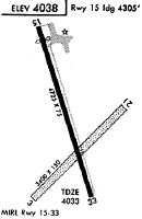
Runway Summary
| Runways: | 04/22 15/33 |
| Longest Runway: | 15/33 is 5201 ft (1585 m) long |
| Runways with an Instrument Approach: |
STK Airport Runway Details
| Runway 04/22 | 2809 ft x 150 ft (856 m x 46 m) | |
| Runway Length Source: | OWNER as of 07/18/2014 | |
| Surface: | Turf/Gravel - Fair condition - No special surface treatment | |
Runway 04 |
Runway 22 |
|
Elevation: |
4032.2 | 4028.7 |
Latitude: |
40-36-37.2855N | 40-36-56.7753N |
Longitude: |
103-16-04.1444W | 103-15-38.2140W |
|
Runway True Alignment: |
045 | 225 |
Glide Path Angle: |
0.0 degrees | 0.0 degrees |
Runway Markings Condition: |
Fair | Fair |
Object at End: |
ROAD | TREE |
Object Height: |
16 | 48 |
Distance from End: |
139 | 614 |
Object Centerline Offset: |
7 ft. left of centerline | 34 ft. right of centerline |
| Runway 15/33 | 5201 ft x 75 ft (1585 m x 23 m) | |
| Runway Length Source: | 3RD PARTY SURVEY as of 01/05/2011 | |
| Surface: | Turf/Gravel - Fair condition - No special surface treatment | |
| Runway Edge Lights: | Medium Intensity | |
Runway Weight Bearing Capacity (in thousands of pounds) |
||
| Single Wheel Landing Gear: | 30.0 | |
Runway 15 |
Runway 33 |
|
Elevation: |
4037.5 | 4025.6 |
Latitude: |
40-37-18.4071N | 40-36-29.3382N |
Longitude: |
103-16-01.4269W | 103-15-41.4286W |
|
Runway True Alignment: |
163 | 343 |
Glide Path Angle: |
3.0 degrees | 3.0 degrees |
Traffic Pattern: |
Left | Left |
Runway Markings Type: |
Nonprecision Instrument | Precision Instrument |
Runway Markings Condition: |
Good | Good |
Object at End: |
TREE | |
Object Height: |
31 | |
Distance from End: |
608 | |
Object Centerline Offset: |
7 ft. left of centerline | 34 ft. right of centerline |
Visual Glide Slope Indicators: |
2-Light PAPI On Left Side Of Runway | 2-Light PAPI On Left Side Of Runway |
REIL: |
Yes | Yes |
Threshold Crossing Height: |
44 | 44 |
Services
Airframe Repair: |
None |
Powerplant Repair: |
None |
Bottled Oxygen: |
None |
Bulk Oxygen: |
None |
Fuel Available: |
100LL |
Landing Fees: |
No |
Parking: |
Tiedowns available |
Maps & Diagrams
STK Sectional
Flight Planning
at skyvector.com
at skyvector.com