Location
Latitude: |
29-41-24.2000N (29.690056) |
Longitude: |
082-16-18.4000W (-82.271778) |
Elevation: |
151.4 feet MSL (46 m MSL) |
Magnetic Variation: |
6.4 W (as of April 2024 from WMM2020 model) |
Time Zone: |
UTC -5.0 (Standard Time) UTC -4.0 (Daylight Savings Time) |
From City: |
03 N.M. NE of Gainesville, Florida |
Found On: |
Jacksonville Chart |
FAA Region: |
ASO |
Contacts
Manager: |
Publicly owned: |
| ALLAN PENKSA 3880 NE 39 AVE STE A GAINESVILLE, FL 32609 352-373-0249 |
GAINESVILLE-ALACHUA CO AUTH 3880 NE 39TH AVE GAINESVILLE, FL 32609 352-373-0249 |
Operations
Airport Status: |
Operational |
Facility Use: |
Public |
Type: |
Airport |
Activation Date: |
04/1940 |
Control tower: |
Yes |
Attendance (Months/Days/Hours): |
Months/Days/Hours ALL/ALL/ALL |
Boundary ARTCC: |
ZJX (Jacksonville) |
Responsible ARTCC: |
ZJX (Jacksonville) |
Lighting Schedule: |
SEE RMK |
Segmented Circle Indicator: |
Yes |
Traffic Pattern Altitude (MSL): |
1151 feet (351 m) |
NOTAMs Facility: |
GNV |
NOTAM-D Service: |
Yes |
International Airport of Entry: |
No |
Customs Landing Rights: |
No |
Military Landing Rights: |
Yes |
Civil/Military Joint Use: |
No |
Aircraft Rescue and Firefighting: |
Class I ARFF Index: B Air Carrier Service: Scheduled Certification Date: 05/1973 |
Based Aircraft
| Single Engine: | 98 |
| Multi Engine: | 18 |
| Jet Engine: | 51 |
| GA Helicopters: | 6 |
Annual Operations (as of 11/30/2023)
| Total Operations: | 75254 | |
| Commercial: | 5971 | 7.9% |
| Air Taxi: | 4838 | 6.4% |
| GA Local: | 17028 | 22.6% |
| GA Itinerant: | 42041 | 55.9% |
| Military Aircraft: | 5376 | 7.1% |
Communications
| CTAF: | 119.550 |
| Unicom: | 122.950 |
| Tower: | GAINESVILLE 119.55 353.7 Hrs: 0645-2230 |
| Ground: | 121.7 |
| Approach: | JACKSONVILLE 118.175 ;10000 FT & BLW 118.175 ;10000 FT & BLW |
| Departure: | JACKSONVILLE 118.175 ;10000 FT & BLW 118.175 ;10000 FT & BLW |
| ATIS: | 127.15 Hrs: 24 |
| ASOS: | 127.15 (352-335-8672) |
Fixed Based Operators (FBOs) & Fuel
(Click on a business for detail)
Please help us keep this information up to date. This is a FREE SERVICE just like everything else on Airport Guide! If you see that a business needs to be added, modified, or deleted please fill out our Update Form.
To add, modify, or delete a business click here.
Please help us keep this information up to date. This is a FREE SERVICE just like everything else on Airport Guide! If you see that a business needs to be added, modified, or deleted please fill out our Update Form.
Area Code: 352 |
| Business Name | Frequency | Phone | Fuel Grade |
|---|---|---|---|
| Flightline Gainesville, Inc.
Website Update FBO info |
122.9 | 335-4681 | 100LL, Jet A |

|
 Exxon Avitat |
100LL - 2.43 USD per gallon on 3/25/02 |
Trucks Military Contract Fuel Available April 1, 2002. Base and volume discounts. |
|
|
Exxon Avitat |
Jet A - 2.35 USD per gallon on 3/25/02 |
Trucks Military Contract Fuel Available April 1, 2002. Base and volume discounts. |
| Gulf Atlantic Airways, Inc.
Update FBO info |
Unicom 122.95 | 373-2426 |
Flight Service Stations
| Primary | Alternate | |
| FSS on Field: | N | |
| FSS Name (ID): | Gainesville(GNV) | |
| Frequency: | ||
| Toll Free Phone: | 1-800-WX-BRIEF |
Instrument Procedures / Charts
FAA Terminal Procedures valid from 0901Z 03/21/24 to 0901Z 04/18/24.
There are various types of charts available for an airport. They are listed in the Page Type column. Here is a legend for those types:
APD - Airport Diagram
DP - Departure Procedure Charts
HOT - Hot Spots
IAP - Instrument Approach Procedure Charts
MIN - Minimums
STAR - Standard Terminal Arrival Charts
| Page Type | Page Name | Volume | Action Since Last Cycle |
|---|---|---|---|
| APD | AIRPORT DIAGRAM | SE-3 | |
| IAP | ILS OR LOC RWY 29 | SE-3 | |
| IAP | RNAV (GPS) RWY 07 | SE-3 | |
| IAP | RNAV (GPS) RWY 11 | SE-3 | |
| IAP | RNAV (GPS) RWY 25 | SE-3 | |
| IAP | RNAV (GPS) RWY 29 | SE-3 | |
| MIN | ALTERNATE MINIMUMS | SE-3 | |
| MIN | TAKEOFF MINIMUMS | SE-3 |
Terminal Procedures are only available for airports in several countries with more being added all the time. If you are looking for a specific country's charts, please send an email to support(at)airportguide.com stating the country name. This will be used to prioritize the implementation.
Navigation Aids (Navaids) near GNV
| Dist (NM) | ID | Morse Code | Name | Type | Freq | True Hdg | Mag Hdg |
|---|---|---|---|---|---|---|---|
| 0.1 | GNV | _ _ . _ . . . . _ | Gators | VORTAC | 116.20 | 332 | 338 |
| 5.3 | GN | _ _ . _ . | Wynds | NDB | 269 | 103 | 109 |
| 24.0 | IAK | . . . _ _ . _ | Palatka | NDB | 243 | 95 | 102 |
| 30.8 | OCF | _ _ _ _ . _ . . . _ . | Ocala | VORTAC | 113.70 | 175 | 181 |
| 33.7 | LCQ | . _ . . _ . _ . _ _ . _ | Lake City | NDB | 204 | 331 | 337 |
| 36.0 | RYD | . _ . _ . _ _ _ . . | Reynolds | NDB | 338 | 62 | 69 |
| 37.1 | VQQ | . . . _ _ _ . _ _ _ . _ | Cecil | VOR | 117.90 | 32 | 39 |
| 40.9 | CTY | _ . _ . _ _ . _ _ | Cross City | VORTAC | 112.00 | 262 | 268 |
| 45.1 | NIP | _ . . . . _ _ . | Jacksonville | TACAN | 108.20 | 43 | 50 |
| 51.0 | TAY | _ . _ _ . _ _ | Taylor | VORTAC | 112.90 | 343 | 349 |
| 51.6 | SGJ | . . . _ _ . . _ _ _ | St Augustine | VOR-DME | 109.40 | 71 | 78 |
| 52.5 | JA | . _ _ _ . _ | Dinns | NDB | 344 | 27 | 34 |
| 55.5 | CRG | _ . _ . . _ . _ _ . | Craig | VORTAC | 114.50 | 45 | 52 |
| 55.9 | EYA | . _ . _ _ . _ | Eastport | NDB | 357 | 37 | 44 |
| 56.8 | JAX | . _ _ _ . _ _ . . _ | Jacksonville Intl | VOT | 111.00 | 31 | 38 |
| 57.7 | LEE | . _ . . . . | Leesburg | NDB | 335 | 154 | 161 |
| 60.8 | NRB | _ . . _ . _ . . . | Mayport | TACAN | 111.40 | 46 | 53 |
| 64.1 | DED | _ . . . _ . . | Deland/Dcmsnd | NDB | 201 | 125 | 132 |
| 64.8 | OMN | _ _ _ _ _ _ . | Ormond Beach | VORTAC | 112.60 | 110 | 117 |
| 70.5 | DAB | _ . . . _ _ . . . | Daytona Beach | VOT | 111.00 | 115 | 122 |
Nearby Airports with Fuel
Notices to Airmen (NOTAMS)
Remarks
| A11 | GAINESVILLE-ALACHUA CO REGIONAL ARPT AUTHORITY |
| A110*G | THIS AIRPORT HAS BEEN SURVEYED BY THE NATIONAL GEODETIC SURVEY. |
| A110-1 | WHEN ATCT CLSD ACFT MORE THAN 12500 LBS CTC FBO FOR PRKG INSTR PRIOR TO EXITING TWY A DUE TO IREG PAVEMENT STRENGTHS - 352-335-4681. |
| A110-10 | GA RAMP LMTD TO ACFT 90000 LB MAX GROSS TKOF WT, DUAL WHEEL OR BLW; OTHERS PPR. |
| A110-11 | BANNER TOWING NA EXC 72 HR PPR - AMGR. |
| A110-12 | ARPT SFC COND NOT MNTD BTW 2330 - 0400 DLY. |
| A110-13 | FOR CD IF UNA TO CTC ON FSS FREQ, CTC JACKSONVILLE APCH AT 904-741-0284. |
| A110-14 | RWY 29 HLDG PSN SIGN AT 07/25 RIGHT SIDE MISG. |
| A110-6 | PORTIONS OF RWY 07/25 & NE 1000 FT OF TWY A NOT VSB FM ATCT; BLOCKED BY VORTAC BLDG. |
| A110-9 | WILDLIFE ON & INVOF ARPT. |
| A26 | RWY 7/25 NOT AVBL FOR SKED ACR OPS WITH MORE THAN 9 PAX SEATS OR UNSKED ACR AT LEAST 31 PAX SEATS. |
| A30-07/25 | ACR NA. |
| A34-11/29 | STD GROOVING FULL LENGTH AND 130 FT WIDE CENTER PORTION. |
| A81-APT | WHEN ATCT CLSD ACTVT MALSR RWY 29; MIRL RWY 07/25; HIRL RWY 11/29 - CTAF. |
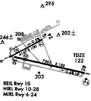
Runways
Runway Summary
| Runways: | 07/25 11/29 |
| Longest Runway: | 11/29 is 7504 ft (2287 m) long |
| Runways with an Instrument Approach: | 29 |
GNV Airport Runway Details
| Runway 07/25 | 4158 ft x 100 ft (1267 m x 30 m) | |
| Runway Length Source: | NGS as of 01/29/2008 | |
| Surface: | Asphalt - Fair condition - Saw-cut or plastic grooved | |
| Runway Pavement Class: | 43 /F/B/X/T | |
| Runway Edge Lights: | Medium Intensity | |
Runway Weight Bearing Capacity (in thousands of pounds) |
||
| Single Wheel Landing Gear: | 107.0 | |
| Dual Wheel Landing Gear: | 172.0 | |
Runway 07 |
Runway 25 |
|
Elevation: |
151.4 | 130.2 |
Latitude: |
29-41-25.1021N | 29-41-45.0383N |
Longitude: |
082-16-56.6098W | 082-16-15.3666W |
|
Runway True Alignment: |
061 | 241 |
Glide Path Angle: |
3.0 degrees | 3.0 degrees |
Traffic Pattern: |
Left | Left |
Runway Markings Type: |
Nonprecision Instrument | Nonprecision Instrument |
Runway Markings Condition: |
Good | Good |
Object at End: |
TREES | TREES |
Object Height: |
70 | 34 |
Distance from End: |
2006 | 1389 |
Object Centerline Offset: |
432 ft. left of centerline | 423 ft. left of centerline |
Visual Glide Slope Indicators: |
4-Light PAPI On Left Side Of Runway | 4-Light PAPI On Left Side Of Runway |
REIL: |
No | |
Threshold Crossing Height: |
44 | 42 |
| Runway 11/29 | 7504 ft x 150 ft (2287 m x 46 m) | |
| Runway Length Source: | NGS as of 01/29/2008 | |
| Surface: | Asphalt - Fair condition - Saw-cut or plastic grooved | |
| Runway Pavement Class: | 56 /F/B/W/T | |
| Runway Edge Lights: | High Intensity | |
Runway Weight Bearing Capacity (in thousands of pounds) |
||
| Single Wheel Landing Gear: | 120.0 | |
| Dual Wheel Landing Gear: | 218.0 | |
| Dual Tandem Wheel Landing Gear: | 372.0 | |
| Dual Dual Tandem Wheel Landing Gear: | 870.0 | |
Runway 11 |
Runway 29 |
|
Elevation: |
147.4 | 105.1 |
Latitude: |
29-41-26.0061N | 29-41-10.2134N |
Longitude: |
082-16-50.1548W | 082-15-27.0276W |
|
Runway True Alignment: |
102 | 282 |
ILS Type: |
ILS | |
Glide Path Angle: |
3.0 degrees | 3.0 degrees |
Runway Markings Type: |
Precision Instrument | Precision Instrument |
Runway Markings Condition: |
Good | Good |
Object at End: |
TREES | TREES |
Object Height: |
81 | 68 |
Distance from End: |
2783 | 3535 |
Object Centerline Offset: |
432 ft. left of centerline | 423 ft. left of centerline |
Visual Glide Slope Indicators: |
4-Light PAPI On Left Side Of Runway | 4-Light PAPI On Right Side Of Runway |
Runway Visual Range (RVR): |
Rollout | Touchdown |
Approach Light System: |
1,400 Foot Medium Intensity Approach Lighting System With Runway Alignment Indicator Lights | |
REIL: |
Yes | |
Threshold Crossing Height: |
54 | 55 |
Services
Airframe Repair: |
Major |
Powerplant Repair: |
Major |
Bottled Oxygen: |
None |
Bulk Oxygen: |
None |
Fuel Available: |
100LL, Jet A, UL94 |
Landing Fees: |
No |
Parking: |
Hangars and tiedowns available |
Maps & Diagrams
GNV Sectional
Flight Planning
at skyvector.com
at skyvector.com