Location
Latitude: |
35-50-14.6970N (35.837416) |
Longitude: |
087-26-43.3570W (-87.445377) |
Elevation: |
765.0 feet MSL (233 m MSL) |
Magnetic Variation: |
3.7 W (as of April 2024 from WMM2020 model) |
Time Zone: |
UTC -6.0 (Standard Time) UTC -5.0 (Daylight Savings Time) |
From City: |
03 N.M. N of Centerville, Tennessee |
Found On: |
Atlanta Chart |
FAA Region: |
ASO |
Contacts
Manager: |
Publicly owned: |
| WOODY WOODRUFF 2650 AIRPORT RD CENTERVILLE, TN 37033 931-729-3032 |
TOWN OF CENTERVILLE 102 EAST SWAN CENTERVILLE, TN 37033 931-729-4246 |
Operations
Airport Status: |
Operational |
Facility Use: |
Public |
Type: |
Airport |
Activation Date: |
05/1960 |
Control tower: |
No |
Attendance (Months/Days/Hours): |
Months/Days/Hours ALL/MON-FRI/0730-1600 |
Boundary ARTCC: |
ZME (Memphis) |
Responsible ARTCC: |
ZME (Memphis) |
Lighting Schedule: |
SEE RMK |
Segmented Circle Indicator: |
Yes |
Traffic Pattern Altitude (MSL): |
1765 feet (538 m) |
NOTAMs Facility: |
MKL |
NOTAM-D Service: |
Yes |
International Airport of Entry: |
No |
Customs Landing Rights: |
No |
Military Landing Rights: |
No |
Civil/Military Joint Use: |
No |
Based Aircraft
| Single Engine: | 14 |
| Multi Engine: | 3 |
Annual Operations (as of 12/31/2016)
| Total Operations: | 3112 | |
| GA Local: | 1912 | 61.4% |
| GA Itinerant: | 1000 | 32.1% |
| Military Aircraft: | 200 | 6.4% |
Communications
| CTAF: | 122.800 |
| Unicom: | 122.800 |
- APCH/DEP SVC PRVDD BY MEMPHIS ARTCC ON FREQS 125.85/379.25 (CENTERVILLE RCAG).
Fixed Based Operators (FBOs) & Fuel
(Click on a business for detail)
Please help us keep this information up to date. This is a FREE SERVICE just like everything else on Airport Guide! If you see that a business needs to be added, modified, or deleted please fill out our Update Form.
To add, modify, or delete a business click here.
Please help us keep this information up to date. This is a FREE SERVICE just like everything else on Airport Guide! If you see that a business needs to be added, modified, or deleted please fill out our Update Form.
Area Code: 931 |
| Business Name | Frequency | Phone | Fuel Grade |
|---|---|---|---|
| Centerville Aviation
Update FBO info |
729-2266, -4170 | 100LL |
Flight Service Stations
| Primary | Alternate | |
| FSS on Field: | N | |
| FSS Name (ID): | Jackson(MKL) | |
| Frequency: | ||
| Toll Free Phone: | 1-800-WX-BRIEF |
Instrument Procedures / Charts
FAA Terminal Procedures valid from 0901Z 03/21/24 to 0901Z 04/18/24.
There are various types of charts available for an airport. They are listed in the Page Type column. Here is a legend for those types:
APD - Airport Diagram
DP - Departure Procedure Charts
HOT - Hot Spots
IAP - Instrument Approach Procedure Charts
MIN - Minimums
STAR - Standard Terminal Arrival Charts
| Page Type | Page Name | Volume | Action Since Last Cycle |
|---|---|---|---|
| IAP | RNAV (GPS) RWY 02 | SE-1 | |
| IAP | RNAV (GPS) RWY 20 | SE-1 | |
| MIN | TAKEOFF MINIMUMS | SE-1 |
Terminal Procedures are only available for airports in several countries with more being added all the time. If you are looking for a specific country's charts, please send an email to support(at)airportguide.com stating the country name. This will be used to prioritize the implementation.
Navigation Aids (Navaids) near GHM
| Dist (NM) | ID | Morse Code | Name | Type | Freq | True Hdg | Mag Hdg |
|---|---|---|---|---|---|---|---|
| 0.4 | GHM | _ _ . . . . . _ _ | Graham | DME | 111.6 | 235 | 239 |
| 17.4 | DMZ | _ . . _ _ _ _ . . | Dickson | NDB | 203 | 2 | 6 |
| 22.1 | AEY | . _ . _ . _ _ | Waverly | NDB | 329 | 319 | 323 |
| 22.1 | PBC | . _ _ . _ . . . _ . _ . | Maury County | NDB | 365 | 128 | 132 |
| 24.2 | JHG | . _ _ _ . . . . _ _ . | Hohenwald | NDB | 257 | 201 | 205 |
| 37.0 | LUG | . _ . . . . _ _ _ . | Verona | NDB | 251 | 122 | 126 |
| 37.2 | LRT | . _ . . . _ . _ | Lawrenceburg | NDB | 269 | 165 | 169 |
| 41.1 | BNA | _ . . . _ . . _ | Nashville | VORTAC | 114.10 | 63 | 67 |
| 41.5 | CK | _ . _ . _ . _ | Snuff | NDB | 335 | 3 | 7 |
| 41.6 | BNA | _ . . . _ . . _ | Nashville Metropoln | VOT | 108.60 | 66 | 70 |
| 43.5 | ON | _ _ _ _ . | Music | NDB | 279 | 30 | 34 |
| 44.3 | VI | . . . _ . . | Opery | NDB | 344 | 60 | 64 |
| 46.6 | MQY | _ _ _ _ . _ _ . _ _ | Smyrna | VOT | 110.20 | 77 | 81 |
| 46.7 | JKS | . _ _ _ _ . _ . . . | Jacks Creek | VOR-DME | 109.40 | 252 | 255 |
| 47.1 | CKV | _ . _ . _ . _ . . . _ | Clarksville | VOR-DME | 110.60 | 1 | 5 |
| 48.2 | SWZ | . . . . _ _ _ _ . . | Sewart | NDB | 391 | 81 | 85 |
| 49.4 | HXW | . . . . _ . . _ . _ _ | Screaming Eagle | TACAN | 114.90 | 356 | 360 |
| 51.7 | SYI | . . . _ . _ _ . . | Shelbyville | VOR-DME | 113.55 | 108 | 112 |
| 51.8 | HZD | . . . . _ _ . . _ . . | Huntingdon | NDB | 217 | 287 | 290 |
| 52.3 | SYI | . . . _ . _ _ . . | Bomar | FAN MARKER | 113 | 117 |
Nearby Airports with Fuel
Notices to Airmen (NOTAMS)
Remarks
| A110-1 | FOR CD CTC MEMPHIS ARTCC AT 901-368-8453/8449. |
| A17 | AFT HR - 615-418-2164. |
| A43-20 | PAPI UNUSBL BYD 5 DEGS LEFT OF CNTRLN. |
| A70-FUEL-10 | 0LL FUEL AVBL H24 WITH CREDIT CARD. |
| A81-APT | MIRL RWY 02/20 OPR DUSK-DAWN & PRESET LOW INTST; INCR INTST & ACTVT - CTAF. 0730-1600 ACTVT VGSI RWY 02 - CTAF. |
Runways
Runway Summary
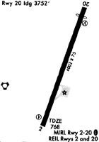
| Runways: | 02/20 |
| Longest Runway: | 02/20 is 4002 ft (1220 m) long |
| Runways with an Instrument Approach: |
GHM Airport Runway Details
| Runway 02/20 | 4002 ft x 75 ft (1220 m x 23 m) | |
| Runway Length Source: | NGS as of 03/13/2009 | |
| Surface: | Asphalt - Good condition - No special surface treatment | |
| Runway Edge Lights: | Medium Intensity | |
Runway Weight Bearing Capacity (in thousands of pounds) |
||
| Single Wheel Landing Gear: | 21.0 | |
| Dual Wheel Landing Gear: | 31.0 | |
Runway 02 |
Runway 20 |
|
Elevation: |
765.0 | 765.0 |
Latitude: |
35-49-55.8951N | 35-50-33.4996N |
Longitude: |
087-26-50.9361W | 087-26-35.7760W |
|
Runway True Alignment: |
018 | 198 |
Glide Path Angle: |
4.0 degrees | 4.0 degrees |
Traffic Pattern: |
Left | Left |
Runway Markings Type: |
Nonprecision Instrument | Nonprecision Instrument |
Runway Markings Condition: |
Good | Good |
Object at End: |
TREES | TREE |
Object Height: |
72 | 98 |
Distance from End: |
983 | 1519 |
Object Centerline Offset: |
980 ft. right of centerline | 171 ft. right of centerline |
Visual Glide Slope Indicators: |
4-Light PAPI On Left Side Of Runway | 4-Light PAPI On Left Side Of Runway |
REIL: |
Yes | Yes |
Threshold Crossing Height: |
43 | 53 |
Threshold Elevation: |
763.2 | |
Displaced Threshold: |
250 | |
Threshold Latitude: |
35-50-31.1510N | |
Threshold Longitude: |
087-26-36.7240W |
Services
Airframe Repair: |
None |
Powerplant Repair: |
None |
Bottled Oxygen: |
None |
Bulk Oxygen: |
None |
Fuel Available: |
100LL, Jet A |
Landing Fees: |
No |
Parking: |
Hangars and tiedowns available |
Maps & Diagrams
GHM Sectional
Flight Planning
at skyvector.com
at skyvector.com