Location
Latitude: |
35-33-33.8400N (35.5594) |
Longitude: |
086-26-32.8990W (-86.442472) |
Elevation: |
799.6 feet MSL (244 m MSL) |
Magnetic Variation: |
4.3 W (as of April 2024 from WMM2020 model) |
Time Zone: |
UTC -6.0 (Standard Time) UTC -5.0 (Daylight Savings Time) |
From City: |
04 N.M. N of Shelbyville, Tennessee |
Found On: |
Atlanta Chart |
FAA Region: |
ASO |
Contacts
Manager: |
Publicly owned: |
| PAUL PERRY 2828 HIGHWAY 231N SHELBYVILLE, TN 37160 931-684-1669 |
CITY OF SHELBYVILLE 201 NORTH SPRING STREET, CITY HALL PO BOX185 SHELBYVILLE, TN 37160 931-684-2691 |
Operations
Airport Status: |
Operational |
Facility Use: |
Public |
Type: |
Airport |
Activation Date: |
11/1946 |
Control tower: |
No |
Attendance (Months/Days/Hours): |
Months/Days/Hours ALL/MON - SAT/0700 - 1900 |
Boundary ARTCC: |
ZME (Memphis) |
Responsible ARTCC: |
ZME (Memphis) |
Lighting Schedule: |
SEE RMK |
Segmented Circle Indicator: |
Yes |
Traffic Pattern Altitude (MSL): |
1800 feet (549 m) |
NOTAMs Facility: |
BNA |
NOTAM-D Service: |
Yes |
International Airport of Entry: |
No |
Customs Landing Rights: |
No |
Military Landing Rights: |
Yes |
Civil/Military Joint Use: |
No |
Based Aircraft
| Single Engine: | 51 |
| Multi Engine: | 3 |
| Jet Engine: | 2 |
Annual Operations (as of 04/26/2022)
| Total Operations: | 50179 | |
| Air Taxi: | 415 | 0.8% |
| GA Local: | 3164 | 6.3% |
| GA Itinerant: | 46500 | 92.7% |
| Military Aircraft: | 100 | 0.2% |
Communications
| CTAF: | 122.800 |
| Unicom: | 122.800 |
| AWOS-3: | 119.275 (931-685-4723) |
- APCH/DEP SVC PRVDD BY MEMPHIS ARTCC ON FREQS 128.15/323.125 (SHELBYVILLE RCAG).
Fixed Based Operators (FBOs) & Fuel
(Click on a business for detail)
Please help us keep this information up to date. This is a FREE SERVICE just like everything else on Airport Guide! If you see that a business needs to be added, modified, or deleted please fill out our Update Form.
To add, modify, or delete a business click here.
Please help us keep this information up to date. This is a FREE SERVICE just like everything else on Airport Guide! If you see that a business needs to be added, modified, or deleted please fill out our Update Form.
Area Code: 931 |
| Business Name | Frequency | Phone | Fuel Grade |
|---|---|---|---|
| Shelbyville Aviation Services, Inc.
Update FBO info |
Unicom 122.8 | 684-1669, after hours call 684-1669 | 100LL, Jet A |
Flight Service Stations
| Primary | Alternate | |
| FSS on Field: | N | |
| FSS Name (ID): | Nashville(BNA) | |
| Frequency: | ||
| Toll Free Phone: | 1-800-WX-BRIEF |
Instrument Procedures / Charts
FAA Terminal Procedures valid from 0901Z 03/21/24 to 0901Z 04/18/24.
There are various types of charts available for an airport. They are listed in the Page Type column. Here is a legend for those types:
APD - Airport Diagram
DP - Departure Procedure Charts
HOT - Hot Spots
IAP - Instrument Approach Procedure Charts
MIN - Minimums
STAR - Standard Terminal Arrival Charts
| Page Type | Page Name | Volume | Action Since Last Cycle |
|---|---|---|---|
| IAP | RNAV (GPS) RWY 18 | SE-1 | |
| IAP | RNAV (GPS) Y RWY 36 | SE-1 | |
| IAP | RNAV (GPS) Z RWY 36 | SE-1 | |
| IAP | VOR RWY 18 | SE-1 | |
| IAP | VOR RWY 36 | SE-1 | |
| IAP | VOR/DME RWY 18 | SE-1 | |
| MIN | ALTERNATE MINIMUMS | SE-1 | |
| MIN | TAKEOFF MINIMUMS | SE-1 |
Terminal Procedures are only available for airports in several countries with more being added all the time. If you are looking for a specific country's charts, please send an email to support(at)airportguide.com stating the country name. This will be used to prioritize the implementation.
Navigation Aids (Navaids) near SYI
| Dist (NM) | ID | Morse Code | Name | Type | Freq | True Hdg | Mag Hdg |
|---|---|---|---|---|---|---|---|
| 0.2 | SYI | . . . _ . _ _ . . | Shelbyville | VOR-DME | 113.55 | 46 | 50 |
| 4.7 | SYI | . . . _ . _ _ . . | Bomar | FAN MARKER | 193 | 197 | |
| 11.4 | ULH | . . _ . _ . . . . . . | Burwi | NDB | 332 | 120 | 124 |
| 14.4 | UXM | . . _ _ . . _ _ _ | Tullahoma Regional | VOR | 109.65 | 138 | 142 |
| 18.3 | LUG | . _ . . . . _ _ _ . | Verona | NDB | 251 | 258 | 262 |
| 23.9 | SWZ | . . . . _ _ _ _ . . | Sewart | NDB | 391 | 357 | 361 |
| 24.4 | FQW | . . _ . _ _ . _ . _ _ | Walter Hill | NDB | 371 | 8 | 12 |
| 26.0 | TNY | _ _ . _ . _ _ | Kelso | NDB | 358 | 190 | 194 |
| 27.0 | MQY | _ _ _ _ . _ _ . _ _ | Smyrna | VOT | 110.20 | 353 | 357 |
| 29.3 | BGF | _ . . . _ _ . . . _ . | Boiling Fork | NDB | 263 | 141 | 145 |
| 31.8 | PBC | . _ _ . _ . . . _ . _ . | Maury County | NDB | 365 | 275 | 279 |
| 35.0 | BNA | _ . . . _ . . _ | Nashville Metropoln | VOT | 108.60 | 342 | 346 |
| 35.0 | RN | . _ . _ . | Warri | NDB | 209 | 70 | 75 |
| 36.6 | BNA | _ . . . _ . . _ | Nashville | VORTAC | 114.10 | 341 | 345 |
| 38.5 | JUE | . _ _ _ . . _ . | Lebanon | NDB | 414 | 9 | 13 |
| 40.0 | VI | . . . _ . . | Opery | NDB | 344 | 345 | 349 |
| 40.0 | SKN | . . . _ . _ _ . | Hurricane | NDB | 256 | 50 | 55 |
| 44.5 | LRT | . _ . . . _ . _ | Lawrenceburg | NDB | 269 | 244 | 248 |
| 46.7 | RQZ | . _ . _ _ . _ _ _ . . | Rocket | VORTAC | 112.20 | 191 | 195 |
| 49.0 | HEM | . . . . . _ _ | Huchn | NDB | 233 | 58 | 63 |
Nearby Airports with Fuel
Notices to Airmen (NOTAMS)
Remarks
| A15 | EMAIL ADDRESS: PAUL.PERRY@SHELBYVILLETNAIRPORT.ORG |
| A17 | UNATNDD THANKSGIVING & CHRISTMAS; AFT HR - AMGR. |
| A70-FUEL-10 | 0LL SELF SERV AVBL H24. |
| A81-APT | ACTVT MIRL RWY 18/36 - CTAF. MIRL RWY 18/36 PRESET LOW INTST; INCR INTST - CTAF. |
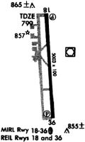
Runways
Runway Summary
| Runways: | 18/36 |
| Longest Runway: | 18/36 is 5504 ft (1678 m) long |
| Runways with an Instrument Approach: |
SYI Airport Runway Details
| Runway 18/36 | 5504 ft x 100 ft (1678 m x 30 m) | |
| Runway Length Source: | 3RD PARTY SURVEY as of 06/03/2022 | |
| Surface: | Asphalt - Good condition - No special surface treatment | |
| Runway Edge Lights: | Medium Intensity | |
Runway Weight Bearing Capacity (in thousands of pounds) |
||
| Single Wheel Landing Gear: | 42.0 | |
| Dual Wheel Landing Gear: | 49.0 | |
| Dual Tandem Wheel Landing Gear: | 75.0 | |
Runway 18 |
Runway 36 |
|
Elevation: |
799.0 | 793.3 |
Latitude: |
35-34-01.0548N | 35-33-06.6255N |
Longitude: |
086-26-33.2723W | 086-26-32.5262W |
|
Runway True Alignment: |
179 | 359 |
Glide Path Angle: |
3.0 degrees | 3.0 degrees |
Traffic Pattern: |
Left | Left |
Runway Markings Type: |
Nonprecision Instrument | Nonprecision Instrument |
Runway Markings Condition: |
Good | Good |
Visual Glide Slope Indicators: |
4-Light PAPI On Left Side Of Runway | 4-Light PAPI On Right Side Of Runway |
REIL: |
Yes | Yes |
Threshold Crossing Height: |
26 | 30 |
Services
Airframe Repair: |
Major |
Powerplant Repair: |
Major |
Fuel Available: |
100LL, Jet A+ |
Landing Fees: |
No |
Parking: |
Hangars and tiedowns available |
Maps & Diagrams
SYI Sectional
Flight Planning
at skyvector.com
at skyvector.com