Location
Latitude: |
34-18-56.6000N (34.315722) |
Longitude: |
081-06-30.8000W (-81.108556) |
Elevation: |
577.5 feet MSL (176 m MSL) |
Magnetic Variation: |
7.7 W (as of April 2024 from WMM2020 model) |
Time Zone: |
UTC -5.0 (Standard Time) UTC -4.0 (Daylight Savings Time) |
From City: |
03 N.M. SW of Winnsboro, South Carolina |
Found On: |
Charlotte Chart |
FAA Region: |
ASO |
Contacts
Manager: |
Publicly owned: |
| DENISE BRYAN 1291 RUNWAY RD WINNSBORO, SC 29180 (803) 718-0087 |
FAIRFIELD COUNTY PO BOX 216 WINNSBORO, SC 29180 (803) 635-1058 |
Operations
Airport Status: |
Operational |
Facility Use: |
Public |
Type: |
Airport |
Activation Date: |
06/1975 |
Control tower: |
No |
Attendance (Months/Days/Hours): |
Months/Days/Hours MAR-OCT/ALL/0800-1800 |
Boundary ARTCC: |
ZJX (Jacksonville) |
Responsible ARTCC: |
ZJX (Jacksonville) |
Lighting Schedule: |
SEE RMK |
Segmented Circle Indicator: |
Yes |
Traffic Pattern Altitude (MSL): |
1578 feet (481 m) |
NOTAMs Facility: |
AND |
NOTAM-D Service: |
Yes |
International Airport of Entry: |
No |
Customs Landing Rights: |
No |
Military Landing Rights: |
Yes |
Civil/Military Joint Use: |
No |
Based Aircraft
| Single Engine: | 32 |
| Multi Engine: | 4 |
Annual Operations (as of 05/08/2019)
| Total Operations: | 7300 | |
| Air Taxi: | 313 | 4.3% |
| GA Local: | 2926 | 40.1% |
| GA Itinerant: | 3761 | 51.5% |
| Military Aircraft: | 300 | 4.1% |
Communications
| CTAF: | 123.050 |
| Unicom: | 123.050 |
| Approach: | COLUMBIA 133.4 133.4 |
| Departure: | COLUMBIA 133.4 133.4 |
| AWOS-3: | 119.075 (803-712-2577) |
Fixed Based Operators (FBOs) & Fuel
(Click on a business for detail)
Please help us keep this information up to date. This is a FREE SERVICE just like everything else on Airport Guide! If you see that a business needs to be added, modified, or deleted please fill out our Update Form.
To add, modify, or delete a business click here.
Please help us keep this information up to date. This is a FREE SERVICE just like everything else on Airport Guide! If you see that a business needs to be added, modified, or deleted please fill out our Update Form.
Area Code: 803 |
| Business Name | Frequency | Phone | Fuel Grade |
|---|---|---|---|
| Kaz-Air, Inc.
Update FBO info |
Unicom 122.8 | 635-3086 | 100LL, Jet A |
Flight Service Stations
| Primary | Alternate | |
| FSS on Field: | N | |
| FSS Name (ID): | Anderson(AND) | |
| Frequency: | ||
| Toll Free Phone: | 1-800-WX-BRIEF |
Instrument Procedures / Charts
FAA Terminal Procedures valid from 0901Z 03/21/24 to 0901Z 04/18/24.
There are various types of charts available for an airport. They are listed in the Page Type column. Here is a legend for those types:
APD - Airport Diagram
DP - Departure Procedure Charts
HOT - Hot Spots
IAP - Instrument Approach Procedure Charts
MIN - Minimums
STAR - Standard Terminal Arrival Charts
| Page Type | Page Name | Volume | Action Since Last Cycle |
|---|---|---|---|
| IAP | RNAV (GPS) RWY 04 | SE-2 | |
| IAP | RNAV (GPS) RWY 22 | SE-2 | |
| MIN | ALTERNATE MINIMUMS | SE-2 | |
| MIN | TAKEOFF MINIMUMS | SE-2 |
Terminal Procedures are only available for airports in several countries with more being added all the time. If you are looking for a specific country's charts, please send an email to support(at)airportguide.com stating the country name. This will be used to prioritize the implementation.
Navigation Aids (Navaids) near KFDW
| Dist (NM) | ID | Morse Code | Name | Type | Freq | True Hdg | Mag Hdg |
|---|---|---|---|---|---|---|---|
| 0.2 | FDW | . . _ . _ . . . _ _ | Winnsboro | NDB | 414 | 248 | 256 |
| 22.0 | CA | _ . _ . . _ | Murry | NDB | 362 | 197 | 205 |
| 26.2 | EOE | . _ _ _ . | Enoree | NDB | 278 | 269 | 277 |
| 27.4 | LKR | . _ . . _ . _ . _ . | Lancaster | NDB | 400 | 26 | 34 |
| 27.6 | CAE | _ . _ . . _ . | Columbia | VORTAC | 114.70 | 174 | 182 |
| 28.0 | MMT | _ _ _ _ _ | Mc Entire | VORTAC | 113.20 | 146 | 154 |
| 28.6 | DCM | _ . . _ . _ . _ _ | Chester | NDB | 220 | 350 | 358 |
| 34.4 | UOT | . . _ _ _ _ _ | Union County | NDB | 326 | 310 | 318 |
| 34.5 | UZ | . . _ _ _ . . | Rally | NDB | 227 | 2 | 10 |
| 37.8 | SSC | . . . . . . _ . _ . | Shaw | TACAN | 110.10 | 122 | 130 |
| 42.0 | SMS | . . . _ _ . . . | Sumter | NDB | 252 | 117 | 125 |
| 43.1 | TWL | _ . _ _ . _ . . | Wesley | NDB | 204 | 27 | 35 |
| 45.9 | CTF | _ . _ . _ . . _ . | Chesterfield | VOR-DME | 114.55 | 63 | 71 |
| 45.9 | PYG | . _ _ . _ . _ _ _ _ . | Pageland | NDB | 270 | 55 | 63 |
| 48.7 | GIW | _ _ . . . . _ _ | Coronaca | NDB | 239 | 265 | 272 |
| 48.9 | AIK | . _ . . _ . _ | Aiken | NDB | 347 | 215 | 223 |
| 49.3 | HVS | . . . . . . . _ . . . | Hartsville | NDB | 341 | 83 | 91 |
| 52.0 | GRD | _ _ . . _ . _ . . | Greenwood | TACAN | 115.50 | 266 | 273 |
| 52.6 | GHJ | _ _ . . . . . . _ _ _ | Stonia | NDB | 260 | 357 | 365 |
| 53.0 | CLT | _ . _ . . _ . . _ | Charlotte | VOR-DME | 115.00 | 8 | 16 |
Nearby Airports with Fuel
Notices to Airmen (NOTAMS)
Remarks
| A110-2 | TPA 1400 MSL. |
| A110-3 | FOR CD CTC COLUMBIA APCH AT 803-822-5242 OR 803-822-5040. |
| A110-4 | (CONTACT TITLE) FOR FBO CALL (803) 635-3086. |
| A81-APT | ACTVT MIRL RY 04/22 & PAPI RYS 04 & 22 - CTAF. |
Runways
Runway Summary
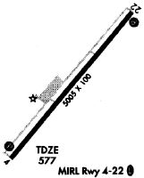
| Runways: | 04/22 |
| Longest Runway: | 04/22 is 5243 ft (1598 m) long |
| Runways with an Instrument Approach: |
KFDW Airport Runway Details
| Runway 04/22 | 5243 ft x 100 ft (1598 m x 30 m) | |
| Runway Length Source: | 3RD PARTY SURVEY as of 01/02/2017 | |
| Surface: | Asphalt - Excellent condition - No special surface treatment | |
| Runway Edge Lights: | Medium Intensity | |
Runway Weight Bearing Capacity (in thousands of pounds) |
||
| Single Wheel Landing Gear: | 42.0 | |
| Dual Wheel Landing Gear: | 60.0 | |
Runway 04 |
Runway 22 |
|
Elevation: |
577.5 | 559.1 |
Latitude: |
34-18-36.2177N | 34-19-16.9456N |
Longitude: |
081-06-50.1547W | 081-06-11.4629W |
|
Runway True Alignment: |
038 | 218 |
Glide Path Angle: |
3.0 degrees | 3.0 degrees |
Traffic Pattern: |
Left | Left |
Runway Markings Type: |
Nonprecision Instrument | Nonprecision Instrument |
Runway Markings Condition: |
Good | Good |
Object at End: |
TREE | TREE |
Object Height: |
25 | 79 |
Distance from End: |
543 | 2820 |
Object Centerline Offset: |
40 ft. right of centerline | 297 ft. right of centerline |
Visual Glide Slope Indicators: |
4-Light PAPI On Left Side Of Runway | 4-Light PAPI On Left Side Of Runway |
Threshold Crossing Height: |
32 | 40 |
Threshold Elevation: |
575.7 | |
Displaced Threshold: |
233 | |
Threshold Latitude: |
34-18-38.0300N | |
Threshold Longitude: |
081-06-48.4400W |
Services
Airframe Repair: |
Major |
Powerplant Repair: |
Major |
Bottled Oxygen: |
None |
Bulk Oxygen: |
None |
Fuel Available: |
100LL |
Landing Fees: |
No |
Parking: |
Tiedowns available |
Maps & Diagrams
KFDW Sectional
Flight Planning
at skyvector.com
at skyvector.com