Location
Latitude: |
38-42-26.7000N (38.707417) |
Longitude: |
093-10-33.3000W (-93.175917) |
Elevation: |
909.7 feet MSL (277 m MSL) |
Magnetic Variation: |
0.2 E (as of April 2024 from WMM2020 model) |
Time Zone: |
UTC -6.0 (Standard Time) UTC -5.0 (Daylight Savings Time) |
From City: |
02 N.M. E of Sedalia, Missouri |
Found On: |
Kansas City Chart |
FAA Region: |
ACE |
Contacts
Manager: |
Publicly owned: |
| DERRICK DODSON 1900 E BOONEVILLE SEDALIA, MO 65301 (660) 851-7650 |
CITY OF SEDALIA 200 S. OSAGE SEDALIA, MO 65301 660-827-3000 |
Operations
Airport Status: |
Operational |
Facility Use: |
Public |
Type: |
Airport |
Activation Date: |
10/1952 |
Control tower: |
No |
Attendance (Months/Days/Hours): |
Months/Days/Hours APR-OCT/MON-FRI/0700-1900 |
Boundary ARTCC: |
ZKC (Kansas City) |
Responsible ARTCC: |
ZKC (Kansas City) |
Lighting Schedule: |
SEE RMK |
Segmented Circle Indicator: |
Yes |
Traffic Pattern Altitude (MSL): |
1910 feet (582 m) |
NOTAMs Facility: |
DMO |
NOTAM-D Service: |
Yes |
International Airport of Entry: |
No |
Customs Landing Rights: |
No |
Military Landing Rights: |
Yes |
Civil/Military Joint Use: |
No |
Based Aircraft
| Single Engine: | 20 |
| Multi Engine: | 2 |
| Jet Engine: | 1 |
Annual Operations (as of 12/31/2020)
| Total Operations: | 11000 | |
| GA Local: | 3850 | 35.0% |
| GA Itinerant: | 4400 | 40.0% |
| Military Aircraft: | 2750 | 25.0% |
Communications
| CTAF: | 122.800 |
| Unicom: | 122.800 |
| Approach: | WHITEMAN KANSAS CITY ARTCC |
| Departure: | WHITEMAN KANSAS CITY ARTCC |
| ASOS: | 120.525 (660-826-8225) |
- APCH/DEP SVC PRVDD BY KANSAS CITY ARTCC ON FREQS 135.575/323.15 (KNOB NOSTER RCAG) WHEN WHITEMAN APCH CTL CLSD.
Fixed Based Operators (FBOs) & Fuel
(Click on a business for detail)
Please help us keep this information up to date. This is a FREE SERVICE just like everything else on Airport Guide! If you see that a business needs to be added, modified, or deleted please fill out our Update Form.
To add, modify, or delete a business click here.
Please help us keep this information up to date. This is a FREE SERVICE just like everything else on Airport Guide! If you see that a business needs to be added, modified, or deleted please fill out our Update Form.
Area Code: 816 |
| Business Name | Frequency | Phone | Fuel Grade |
|---|---|---|---|
| City of Sedalia
Update FBO info |
Unicom 122.8 | 826-4128 | 100LL, Jet A |
| Corporate Air Express
Update FBO info |
Unicom 122.8 | 826-6643 |
Flight Service Stations
| Primary | Alternate | |
| FSS on Field: | N | |
| FSS Name (ID): | Columbia(COU) | |
| Frequency: | ||
| Toll Free Phone: | 1-800-WX-BRIEF |
Instrument Procedures / Charts
FAA Terminal Procedures valid from 0901Z 03/21/24 to 0901Z 04/18/24.
There are various types of charts available for an airport. They are listed in the Page Type column. Here is a legend for those types:
APD - Airport Diagram
DP - Departure Procedure Charts
HOT - Hot Spots
IAP - Instrument Approach Procedure Charts
MIN - Minimums
STAR - Standard Terminal Arrival Charts
| Page Type | Page Name | Volume | Action Since Last Cycle |
|---|---|---|---|
| IAP | RNAV (GPS) RWY 18 | NC-3 | |
| IAP | RNAV (GPS) RWY 36 | NC-3 | |
| MIN | ALTERNATE MINIMUMS | NC-3 | |
| MIN | TAKEOFF MINIMUMS | NC-3 |
Terminal Procedures are only available for airports in several countries with more being added all the time. If you are looking for a specific country's charts, please send an email to support(at)airportguide.com stating the country name. This will be used to prioritize the implementation.
Navigation Aids (Navaids) near DMO
| Dist (NM) | ID | Morse Code | Name | Type | Freq | True Hdg | Mag Hdg |
|---|---|---|---|---|---|---|---|
| 0.2 | DMO | _ . . _ _ _ _ _ | Sedalia | NDB | 281 | 190 | 190 |
| 17.6 | SZL | . . . _ _ . . . _ . . | Whiteman | TACAN | 109.80 | 275 | 275 |
| 20.1 | PUR | . _ _ . . . _ . _ . | Marshall | NDB | 371 | 357 | 357 |
| 31.7 | GLY | _ _ . . _ . . _ . _ _ | Golden Valley | NDB | 388 | 228 | 228 |
| 45.2 | COU | _ . _ . _ _ _ . . _ | Columbia | VOR-DME | 110.20 | 81 | 81 |
| 46.9 | AIZ | . _ . . _ _ . . | Kaiser | NDB | 377 | 141 | 141 |
| 47.7 | JEF | . _ _ _ . . . _ . | Jefferson City | VOT | 112.00 | 97 | 97 |
| 48.3 | SHY | . . . . . . . _ . _ _ | Sunshine | VOR-DME | 108.40 | 145 | 145 |
| 50.2 | ANX | . _ _ . _ . . _ | Napoleon | VORTAC | 114.00 | 297 | 296 |
| 52.6 | JE | . _ _ _ . | Algoa | NDB | 397 | 100 | 100 |
| 54.6 | HLV | . . . . . _ . . . . . _ | Hallsville | VORTAC | 114.20 | 63 | 63 |
| 63.5 | BZK | _ . . . _ _ . . _ . _ | Brookfield | NDB | 383 | 2 | 2 |
| 64.2 | BQS | _ . . . _ _ . _ . . . | Braymer | VOR-DME | 115.35 | 329 | 329 |
| 65.3 | MCM | _ _ _ . _ . _ _ | Macon | DME | 112.9 | 29 | 29 |
| 65.9 | CHT | _ . _ . . . . . _ | Chillicothe | NDB | 375 | 347 | 347 |
| 66.9 | BUM | _ . . . . . _ _ _ | Butler | VORTAC | 115.90 | 247 | 246 |
| 70.8 | RIS | . _ . . . . . . | Riverside | VOR-DME | 111.40 | 290 | 289 |
| 70.9 | MKC | _ _ _ . _ _ . _ . | Kansas City Downtown | VOT | 108.60 | 291 | 290 |
| 72.3 | GQ | _ _ . _ _ . _ | Norge | NDB | 517 | 287 | 286 |
| 72.4 | IEB | . . . _ . . . | Lebanon | NDB | 414 | 160 | 160 |
Nearby Airports with Fuel
Notices to Airmen (NOTAMS)
Remarks
| A105 | ARMY NATIONAL GUARD TRAINING. |
| A110-1 | WILDLIFE ON RYS EARLY MORNING & DUSK. |
| A110-2 | 100LL SELF SERVICE AVBL 24/7 |
| A110-3 | JET A AVBL AFTER HOURS - $80 FEE - CALL 660-826-8100 |
| A110-4 | FOR CD IF UNA TO CTC ON FSS FREQ, CTC WHITEMAN APCH AT 660-687-3132. WHEN WHITEMAN APCH IS CLSD, CTC KANSAS CITY ARTCC AT 913-254-8508. |
| A58-23 | BRUSH 5-6 FT TALL 130-200 FT FM THR 130 FT RIGHT. |
| A81-APT | ACTVT REIL RWY 18 & 36; MIRL RWY 18/36 & 05/23 - CTAF. PAPI RWY 18 & 36 ON 24 HRS. |
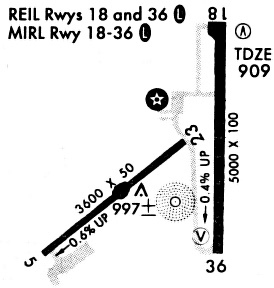
Runways
Runway Summary
| Runways: | 05/23 18/36 |
| Longest Runway: | 18/36 is 5500 ft (1676 m) long |
| Runways with an Instrument Approach: |
DMO Airport Runway Details
| Runway 05/23 | 3519 ft x 50 ft (1073 m x 15 m) | |
| Runway Length Source: | 3RD PARTY SURVEY as of 01/22/2010 | |
| Surface: | Asphalt - Fair condition - No special surface treatment | |
| Runway Pavement Class: | 7 /F/D/X/T | |
| Runway Edge Lights: | Medium Intensity | |
Runway Weight Bearing Capacity (in thousands of pounds) |
||
| Single Wheel Landing Gear: | 19.0 | |
Runway 05 |
Runway 23 |
|
Elevation: |
909.5 | 884.3 |
Latitude: |
38-42-06.0137N | 38-42-26.2318N |
Longitude: |
093-11-09.5805W | 093-10-33.4578W |
|
Runway True Alignment: |
054 | 234 |
Glide Path Angle: |
0.0 degrees | 0.0 degrees |
Traffic Pattern: |
Right | |
Runway Markings Type: |
Basic | Basic |
Runway Markings Condition: |
Good | Good |
Object at End: |
TREE | BRUSH |
Object Height: |
54 | 15 |
Distance from End: |
615 | 243 |
Object Centerline Offset: |
270 ft. left of centerline | 125 ft. left of centerline |
| Runway 18/36 | 5500 ft x 100 ft (1676 m x 30 m) | |
| Runway Length Source: | 3RD PARTY SURVEY as of 12/13/2014 | |
| Surface: | Asphalt - Fair condition - No special surface treatment | |
| Runway Pavement Class: | 17 /R/C/W/T | |
| Runway Edge Lights: | Medium Intensity | |
Runway Weight Bearing Capacity (in thousands of pounds) |
||
| Single Wheel Landing Gear: | 50.0 | |
| Dual Wheel Landing Gear: | 65.0 | |
Runway 18 |
Runway 36 |
|
Elevation: |
882.1 | 900.4 |
Latitude: |
38-43-00.5895N | 38-42-06.2503N |
Longitude: |
093-10-20.5588W | 093-10-22.6026W |
|
Runway True Alignment: |
182 | 002 |
Glide Path Angle: |
3.0 degrees | 3.0 degrees |
Traffic Pattern: |
Right | |
Runway Markings Type: |
Nonprecision Instrument | Nonprecision Instrument |
Runway Markings Condition: |
Good | Good |
Object Centerline Offset: |
270 ft. left of centerline | 125 ft. left of centerline |
Visual Glide Slope Indicators: |
4-Light PAPI On Left Side Of Runway | 4-Light PAPI On Left Side Of Runway |
REIL: |
Yes | Yes |
Threshold Crossing Height: |
40 | 44 |
Services
Bottled Oxygen: |
None |
Bulk Oxygen: |
None |
Fuel Available: |
100LL |
Landing Fees: |
No |
Parking: |
Hangars and tiedowns available |
Maps & Diagrams
DMO Sectional
Flight Planning
at skyvector.com
at skyvector.com