Location
Latitude: |
39-05-43.7220N (39.095478) |
Longitude: |
093-12-10.7990W (-93.203) |
Elevation: |
778.9 feet MSL (237 m MSL) |
Magnetic Variation: |
0.2 E (as of April 2024 from WMM2020 model) |
Time Zone: |
UTC -6.0 (Standard Time) UTC -5.0 (Daylight Savings Time) |
From City: |
02 N.M. S of Marshall, Missouri |
Found On: |
Kansas City Chart |
FAA Region: |
ACE |
Contacts
Manager: |
Publicly owned: |
| MUNI SERVICE DEPT 1277 S. ODELL MARSHALL, MO 65340 660-886-9855 |
CITY OF MARSHALL 214 N LAFAYETTE MARSHALL, MO 65340 660-886-2226 |
Operations
Airport Status: |
Operational |
Facility Use: |
Public |
Type: |
Airport |
Activation Date: |
05/1941 |
Control tower: |
No |
Attendance (Months/Days/Hours): |
Months/Days/Hours APR-SEP/ALL/0700-1800 |
Boundary ARTCC: |
ZKC (Kansas City) |
Responsible ARTCC: |
ZKC (Kansas City) |
Lighting Schedule: |
SEE RMK |
Segmented Circle Indicator: |
Yes |
Traffic Pattern Altitude (MSL): |
1779 feet (542 m) |
NOTAMs Facility: |
COU |
NOTAM-D Service: |
Yes |
International Airport of Entry: |
No |
Customs Landing Rights: |
No |
Military Landing Rights: |
Yes |
Civil/Military Joint Use: |
No |
Based Aircraft
| Single Engine: | 20 |
Annual Operations (as of 12/31/2020)
| Total Operations: | 10046 | |
| Air Taxi: | 350 | 3.5% |
| GA Local: | 4622 | 46.0% |
| GA Itinerant: | 5044 | 50.2% |
| Military Aircraft: | 30 | 0.3% |
Communications
| CTAF: | 122.800 |
| Unicom: | 122.800 |
| Approach: | WHITEMAN KANSAS CITY ARTCC |
| Departure: | WHITEMAN KANSAS CITY ARTCC |
| AWOS-3PT: | 118.675 (660-886-9130) |
- APCH/DEP SVC PRVDD BY KANSAS CITY ARTCC ON FREQS 135.575/323.15 (KNOB NOSTER RCAG) WHEN WHITEMAN APCH CTL CLSD.
Fixed Based Operators (FBOs) & Fuel
(Click on a business for detail)
Please help us keep this information up to date. This is a FREE SERVICE just like everything else on Airport Guide! If you see that a business needs to be added, modified, or deleted please fill out our Update Form.
To add, modify, or delete a business click here.
Please help us keep this information up to date. This is a FREE SERVICE just like everything else on Airport Guide! If you see that a business needs to be added, modified, or deleted please fill out our Update Form.
Area Code: 660 |
| Business Name | Frequency | Phone | Fuel Grade |
|---|---|---|---|
| City of Marshall
Update FBO info |
886-3320 | 100LL |
Flight Service Stations
| Primary | Alternate | |
| FSS on Field: | N | |
| FSS Name (ID): | Columbia(COU) | |
| Frequency: | ||
| Toll Free Phone: | 1-800-WX-BRIEF |
Instrument Procedures / Charts
FAA Terminal Procedures valid from 0901Z 03/21/24 to 0901Z 04/18/24.
There are various types of charts available for an airport. They are listed in the Page Type column. Here is a legend for those types:
APD - Airport Diagram
DP - Departure Procedure Charts
HOT - Hot Spots
IAP - Instrument Approach Procedure Charts
MIN - Minimums
STAR - Standard Terminal Arrival Charts
| Page Type | Page Name | Volume | Action Since Last Cycle |
|---|---|---|---|
| IAP | RNAV (GPS) RWY 18 | NC-3 | |
| IAP | RNAV (GPS) RWY 36 | NC-3 | |
| MIN | TAKEOFF MINIMUMS | NC-3 |
Terminal Procedures are only available for airports in several countries with more being added all the time. If you are looking for a specific country's charts, please send an email to support(at)airportguide.com stating the country name. This will be used to prioritize the implementation.
Navigation Aids (Navaids) near MHL
| Dist (NM) | ID | Morse Code | Name | Type | Freq | True Hdg | Mag Hdg |
|---|---|---|---|---|---|---|---|
| 3.2 | PUR | . _ _ . . . _ . _ . | Marshall | NDB | 371 | 174 | 174 |
| 23.5 | DMO | _ . . _ _ _ _ _ | Sedalia | NDB | 281 | 176 | 176 |
| 27.0 | SZL | . . . _ _ . . . _ . . | Whiteman | TACAN | 109.80 | 217 | 217 |
| 40.4 | BZK | _ . . . _ _ . . _ . _ | Brookfield | NDB | 383 | 6 | 6 |
| 43.1 | CHT | _ . _ . . . . . _ | Chillicothe | NDB | 375 | 341 | 341 |
| 43.1 | ANX | . _ _ . _ . . _ | Napoleon | VORTAC | 114.00 | 270 | 269 |
| 44.8 | BQS | _ . . . _ _ . _ . . . | Braymer | VOR-DME | 115.35 | 316 | 316 |
| 47.3 | MCM | _ _ _ . _ . _ _ | Macon | DME | 112.9 | 44 | 44 |
| 49.0 | COU | _ . _ . _ _ _ . . _ | Columbia | VOR-DME | 110.20 | 110 | 110 |
| 49.6 | GLY | _ _ . . _ . . _ . _ _ | Golden Valley | NDB | 388 | 207 | 207 |
| 50.1 | HLV | . . . . . _ . . . . . _ | Hallsville | VORTAC | 114.20 | 88 | 88 |
| 56.9 | JEF | . _ _ _ . . . _ . | Jefferson City | VOT | 112.00 | 121 | 121 |
| 61.8 | TRX | _ . _ . _ . . _ | Trenton | NDB | 400 | 343 | 343 |
| 62.3 | JE | . _ _ _ . | Algoa | NDB | 397 | 121 | 121 |
| 64.9 | RIS | . _ . . . . . . | Riverside | VOR-DME | 111.40 | 271 | 270 |
| 65.0 | MKC | _ _ _ . _ _ . _ . | Kansas City Downtown | VOT | 108.60 | 271 | 270 |
| 67.2 | AIZ | . _ . . _ _ . . | Kaiser | NDB | 377 | 152 | 152 |
| 67.7 | GQ | _ _ . _ _ . _ | Norge | NDB | 517 | 268 | 267 |
| 68.5 | IRK | . . . _ . _ . _ | Kirksville | VORTAC | 114.60 | 24 | 24 |
| 69.3 | SHY | . . . . . . . _ . _ _ | Sunshine | VOR-DME | 108.40 | 155 | 155 |
Nearby Airports with Fuel
Notices to Airmen (NOTAMS)
Remarks
| A110-1 | HVY SEASONAL AG SPRAY ACFT OPNS ON & INVOF ARPT. |
| A110-2 | FOR CD CTC WHITEMAN APCH AT 660-687-3132. WHEN WHITEMAN APCH IS CLSD, CTC KANSAS CITY ARTCC AT 913-254-8508. |
| A42-09 | RY 09/27 MKD WITH LARGE YELLOW CONES. |
| A57-18 | RWY 18 APCH SLOPE 22:1 TO DSPLCD THR. |
| A70-FUEL-10 | 0LL 100LL AND JET A1+ SELF SERVICE AVBL 24 HRS. |
| A81-APT | ACTVT MIRL RY 18/36; PAPI RYS 18 & 36 AND REIL RY 36- CTAF. |
| E111 | PROVIDED A CLEAR APCH TO EA RY MAINTAINED FOR A 20:1 GLIDE SLOPE; A CLEAR TRANSITIONAL SFC MAINTAINED FOR A 7:1 SLOPE; A RIGHT TFC PATTERN ESTABLISHED TO RY 09; THE ALP UPDATED & COORDINATION OF NEW RY WITH MHTD. |
Runways
Runway Summary
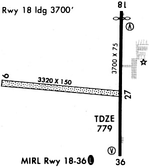
| Runways: | 09/27 18/36 |
| Longest Runway: | 18/36 is 5005 ft (1526 m) long |
| Runways with an Instrument Approach: |
MHL Airport Runway Details
| Runway 09/27 | 3303 ft x 150 ft (1007 m x 46 m) | |
| Runway Length Source: | 3RD PARTY SURVEY as of 04/03/2020 | |
| Surface: | Turf - Excellent condition - No special surface treatment | |
Runway 09 |
Runway 27 |
|
Elevation: |
749.8 | 777.9 |
Latitude: |
39-05-47.6569N | 39-05-44.3986N |
Longitude: |
093-12-45.3934W | 093-12-03.7072W |
|
Runway True Alignment: |
096 | 276 |
Glide Path Angle: |
0.0 degrees | 0.0 degrees |
Traffic Pattern: |
Right | |
Runway Markings Type: |
None | None |
Runway Markings Condition: |
Fair | Fair |
| Runway 18/36 | 5005 ft x 75 ft (1526 m x 23 m) | |
| Runway Length Source: | 3RD PARTY SURVEY as of 04/03/2020 | |
| Surface: | Turf - Excellent condition - No special surface treatment | |
| Runway Edge Lights: | Medium Intensity | |
Runway Weight Bearing Capacity (in thousands of pounds) |
||
| Single Wheel Landing Gear: | 30.0 | |
| Dual Wheel Landing Gear: | 42.0 | |
Runway 18 |
Runway 36 |
|
Elevation: |
770.4 | 778.9 |
Latitude: |
39-06-06.9303N | 39-05-17.4704N |
Longitude: |
093-12-01.1898W | 093-12-02.2569W |
|
Runway True Alignment: |
181 | 001 |
Glide Path Angle: |
3.0 degrees | 3.0 degrees |
Runway Markings Type: |
Nonprecision Instrument | Nonprecision Instrument |
Runway Markings Condition: |
Good | Good |
Object at End: |
TREES | |
Object Height: |
61 | |
Distance from End: |
1085 | |
Visual Glide Slope Indicators: |
4-Light PAPI On Left Side Of Runway | 4-Light PAPI On Left Side Of Runway |
REIL: |
No | Yes |
Threshold Crossing Height: |
39 | 36 |
Threshold Elevation: |
770.7 | |
Displaced Threshold: |
200 | |
Threshold Latitude: |
39-06-04.9534N | |
Threshold Longitude: |
093-12-01.2294W |
Services
Airframe Repair: |
Major |
Powerplant Repair: |
Major |
Bottled Oxygen: |
None |
Bulk Oxygen: |
None |
Fuel Available: |
100LL, Jet A, MOGAS |
Landing Fees: |
No |
Parking: |
Tiedowns available |
Maps & Diagrams
MHL Sectional
Flight Planning
at skyvector.com
at skyvector.com