Location
Latitude: |
37-21-27.1000N (37.357528) |
Longitude: |
078-26-16.1000W (-78.437806) |
Elevation: |
415.7 feet MSL (127 m MSL) |
Magnetic Variation: |
9.7 W (as of April 2024 from WMM2020 model) |
Time Zone: |
UTC -5.0 (Standard Time) UTC -4.0 (Daylight Savings Time) |
From City: |
04 N.M. NW of Farmville, Virginia |
Found On: |
Washington Chart |
FAA Region: |
AEA |
Contacts
Manager: |
Publicly owned: |
| SCOTT DAVIS P.O. DRAWER 368 FARMVILLE, VA 23901-9116 434-392-5686 |
TOWN OF FARMVILLE P.O. DRAWER 368 FARMVILLE, VA 23901 434-392-5686 |
Operations
Airport Status: |
Operational |
Facility Use: |
Public |
Type: |
Airport |
Control tower: |
No |
Attendance (Months/Days/Hours): |
Months/Days/Hours ALL/ALL/0730-1700 |
Boundary ARTCC: |
ZDC (Washington) |
Responsible ARTCC: |
ZDC (Washington) |
Lighting Schedule: |
SEE RMK |
Traffic Pattern Altitude (MSL): |
1416 feet (432 m) |
NOTAMs Facility: |
FVX |
NOTAM-D Service: |
Yes |
International Airport of Entry: |
No |
Customs Landing Rights: |
No |
Military Landing Rights: |
Yes |
Civil/Military Joint Use: |
No |
Based Aircraft
| Single Engine: | 10 |
| Multi Engine: | 1 |
| Jet Engine: | 1 |
Annual Operations (as of 12/31/2020)
| Total Operations: | 14123 | |
| GA Local: | 7771 | 55.0% |
| GA Itinerant: | 5858 | 41.5% |
| Military Aircraft: | 494 | 3.5% |
Communications
| CTAF: | 122.800 |
| Unicom: | 122.800 |
| Approach: | ROANOKE 135.0 135.0 |
| Departure: | ROANOKE 135.0 135.0 |
| AWOS-3: | 132.725 (434-392-9718) |
- APCH/DEP SVC PRVDD BY ATCT ROANOKE ON FREQS 135.0/254.32.
Fixed Based Operators (FBOs) & Fuel
(Click on a business for detail)
Please help us keep this information up to date. This is a FREE SERVICE just like everything else on Airport Guide! If you see that a business needs to be added, modified, or deleted please fill out our Update Form.
To add, modify, or delete a business click here.
Please help us keep this information up to date. This is a FREE SERVICE just like everything else on Airport Guide! If you see that a business needs to be added, modified, or deleted please fill out our Update Form.
Area Code: 804 |
| Business Name | Frequency | Phone | Fuel Grade |
|---|---|---|---|
| Heart of Virginia Aviation
Update FBO info |
Unicom 122.8 | 392-9016 | 100LL, Jet A |

|
 Air BP |
100LL - 2.20 USD per gallon on 10/20/01 |
|
|
|
Air BP |
Jet A - 2.15 USD per gallon on 10/20/01 |
|
Flight Service Stations
| Primary | Alternate | |
| FSS on Field: | N | |
| FSS Name (ID): | Leesburg(DCA) | |
| Frequency: | ||
| Toll Free Phone: | 1-800-WX-BRIEF |
Instrument Procedures / Charts
FAA Terminal Procedures valid from 0901Z 03/21/24 to 0901Z 04/18/24.
There are various types of charts available for an airport. They are listed in the Page Type column. Here is a legend for those types:
APD - Airport Diagram
DP - Departure Procedure Charts
HOT - Hot Spots
IAP - Instrument Approach Procedure Charts
MIN - Minimums
STAR - Standard Terminal Arrival Charts
| Page Type | Page Name | Volume | Action Since Last Cycle |
|---|---|---|---|
| IAP | RNAV (GPS) RWY 03 | NE-3 | |
| IAP | RNAV (GPS) RWY 21 | NE-3 | |
| MIN | ALTERNATE MINIMUMS | NE-3 | |
| MIN | TAKEOFF MINIMUMS | NE-3 |
Terminal Procedures are only available for airports in several countries with more being added all the time. If you are looking for a specific country's charts, please send an email to support(at)airportguide.com stating the country name. This will be used to prioritize the implementation.
Navigation Aids (Navaids) near KFVX
| Dist (NM) | ID | Morse Code | Name | Type | Freq | True Hdg | Mag Hdg |
|---|---|---|---|---|---|---|---|
| 0.3 | FVX | . . _ . . . . _ _ . . _ | Farmville | NDB | 367 | 176 | 186 |
| 23.3 | BKT | _ . . . _ . _ _ | Blackstone | NDB | 326 | 126 | 136 |
| 30.8 | FAK | . . _ . . _ _ . _ | Flat Rock | VORTAC | 113.30 | 70 | 80 |
| 38.6 | LYH | . _ . . _ . _ _ . . . . | Lynchburg | VOR-DME | 109.20 | 261 | 270 |
| 38.9 | LY | . _ . . _ . _ _ | Bojar | NDB | 385 | 261 | 270 |
| 39.3 | AZS | . _ _ _ . . . . . | Azalea Park | NDB | 336 | 354 | 364 |
| 41.3 | LVL | . _ . . . . . _ . _ . . | Lawrenceville | VORTAC | 112.90 | 141 | 151 |
| 41.6 | GVE | _ _ . . . . _ . | Gordonsville | VORTAC | 115.60 | 18 | 28 |
| 43.9 | MBV | _ _ _ . . . . . . _ | Mecklenburg/Dcmsnd | NDB | 356 | 155 | 165 |
| 45.5 | MOL | _ _ _ _ _ . _ . . | Montebello | VOR-DME | 115.30 | 315 | 325 |
| 47.0 | CF | _ . _ . . . _ . | Pubbs | NDB | 392 | 91 | 101 |
| 48.2 | AEA | . _ . . _ | Jones | NDB | 373 | 157 | 167 |
| 49.4 | SBV | . . . _ . . . . . . _ | South Boston | VORTAC | 110.40 | 214 | 224 |
| 53.9 | RIC | . _ . . . _ . _ . | Richmond | VORTAC | 114.10 | 80 | 90 |
| 56.3 | SH | . . . . . . . | Staut | NDB | 375 | 334 | 344 |
| 63.1 | HPW | . . . . . _ _ . . _ _ | Hopewell | VORTAC | 112.00 | 91 | 101 |
| 64.0 | HXO | . . . . _ . . _ _ _ _ | Huntsboro | NDB | 271 | 187 | 197 |
| 64.0 | DAN | _ . . . _ _ . | Danville | VOR | 113.10 | 222 | 231 |
| 65.2 | RZZ | . _ . _ _ . . _ _ . . | Rapids | NDB | 407 | 147 | 157 |
| 65.7 | ELQ | . . _ . . _ _ . _ | Emporia | NDB | 261 | 132 | 142 |
Nearby Airports with Fuel
Notices to Airmen (NOTAMS)
Remarks
| A110-1 | DEER ON AND INVOF ARPT. |
| A110-2 | LGTD TWR 320 AGL 5.8 MI SW. |
| A110-4 | POSS UNMANNED AERIAL VEHICLE OPER 5 NM FROM FARMVILLE ARPT 3000 FT AGL & BLW. |
| A110-5 | ROA TWR SVCS AVBL AT 540-563-1307. |
| A110-6 | FOR CD CTC ROANOKE APCH AT 540-563-1307. |
| A52-03 | TERRAIN 333 FT FROM THR, 128 RIGHT OF CTLN AND 10 FT ABOVE RWY ELEVATION. |
| A81-APT | REIL RWY 3 & 21; MIRL RWY 03/21; PRESET LOW INTST, TO INCR INTST ACTVT - CTAF. |
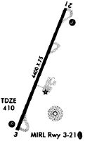
Runways
Runway Summary
| Runways: | 03/21 |
| Longest Runway: | 03/21 is 4400 ft (1341 m) long |
| Runways with an Instrument Approach: |
KFVX Airport Runway Details
| Runway 03/21 | 4400 ft x 75 ft (1341 m x 23 m) | |
| Runway Length Source: | 3RD PARTY SURVEY as of 06/23/2008 | |
| Surface: | Asphalt - Excellent condition - Saw-cut or plastic grooved | |
| Runway Edge Lights: | Medium Intensity | |
Runway Weight Bearing Capacity (in thousands of pounds) |
||
| Single Wheel Landing Gear: | 12.5 | |
Runway 03 |
Runway 21 |
|
Elevation: |
409.7 | 415.7 |
Latitude: |
37-21-06.6914N | 37-21-47.5042N |
Longitude: |
078-26-25.4788W | 078-26-06.6208W |
|
Runway True Alignment: |
020 | 200 |
Glide Path Angle: |
3.0 degrees | 3.0 degrees |
Traffic Pattern: |
Left | Left |
Runway Markings Type: |
Nonprecision Instrument | Nonprecision Instrument |
Runway Markings Condition: |
Good | Good |
Object at End: |
HILL | TREE |
Object Height: |
10 | 35 |
Distance from End: |
333 | 652 |
Object Centerline Offset: |
128 ft. left of centerline | 291 ft. right of centerline |
Visual Glide Slope Indicators: |
2-Light PAPI On Left Side Of Runway | 2-Light PAPI On Left Side Of Runway |
REIL: |
Yes | Yes |
Threshold Crossing Height: |
44 | 45 |
Services
Airframe Repair: |
Major |
Powerplant Repair: |
Major |
Bottled Oxygen: |
None |
Bulk Oxygen: |
None |
Fuel Available: |
100LL, Jet A |
Landing Fees: |
No |
Parking: |
Tiedowns available |
Maps & Diagrams
KFVX Sectional
Flight Planning
at skyvector.com
at skyvector.com