Location
Latitude: |
36-39-56.2230N (36.665618) |
Longitude: |
076-19-14.3610W (-76.320656) |
Elevation: |
18.7 feet MSL (6 m MSL) |
Magnetic Variation: |
10.8 W (as of May 2024 from WMM2020 model) |
Time Zone: |
UTC -5.0 (Standard Time) UTC -4.0 (Daylight Savings Time) |
From City: |
12 N.M. S of Norfolk, Virginia |
Found On: |
Washington Chart |
FAA Region: |
AEA |
Contacts
Manager: |
Publicly owned: |
| CHRIS SCHRANTZ 2800 AIRPORT DRIVE CHESAPEAKE, VA 23323-6402 757-432-8110 |
CHESAPEAKE AIRPORT AUTHORITY 2800 AIRPORT DRIVE CHESAPEAKE, VA 23323-6402 757-432-8110 |
Operations
Airport Status: |
Operational |
Facility Use: |
Public |
Type: |
Airport |
Control tower: |
No |
Attendance (Months/Days/Hours): |
Months/Days/Hours ALL/ALL/0800-2000 |
Boundary ARTCC: |
ZDC (Washington) |
Responsible ARTCC: |
ZDC (Washington) |
Lighting Schedule: |
SEE RMK |
Segmented Circle Indicator: |
Yes |
Traffic Pattern Altitude (MSL): |
1019 feet (311 m) |
NOTAMs Facility: |
CPK |
NOTAM-D Service: |
Yes |
Military Landing Rights: |
Yes |
Based Aircraft
| Single Engine: | 109 |
| Multi Engine: | 9 |
| GA Helicopters: | 2 |
Annual Operations (as of 12/31/2019)
| Total Operations: | 50298 | |
| Air Taxi: | 2023 | 4.0% |
| GA Local: | 33571 | 66.7% |
| GA Itinerant: | 13519 | 26.9% |
| Military Aircraft: | 1185 | 2.4% |
Communications
| CTAF: | 123.075 |
| Unicom: | 123.075 |
| Approach: | NORFOLK |
| Departure: | NORFOLK |
| AWOS-3: | 123.675 (757-204-4290) |
Fixed Based Operators (FBOs) & Fuel
(Click on a business for detail)
Please help us keep this information up to date. This is a FREE SERVICE just like everything else on Airport Guide! If you see that a business needs to be added, modified, or deleted please fill out our Update Form.
To add, modify, or delete a business click here.
Please help us keep this information up to date. This is a FREE SERVICE just like everything else on Airport Guide! If you see that a business needs to be added, modified, or deleted please fill out our Update Form.
Area Code: 757 |
| Business Name | Frequency | Phone | Fuel Grade |
|---|
Flight Service Stations
| Primary | Alternate | |
| FSS on Field: | N | |
| FSS Name (ID): | Leesburg(DCA) | |
| Frequency: | ||
| Toll Free Phone: | 1-800-WX-BRIEF |
Instrument Procedures / Charts
FAA Terminal Procedures valid from 0901Z 03/21/24 to 0901Z 04/18/24.
There are various types of charts available for an airport. They are listed in the Page Type column. Here is a legend for those types:
APD - Airport Diagram
DP - Departure Procedure Charts
HOT - Hot Spots
IAP - Instrument Approach Procedure Charts
MIN - Minimums
STAR - Standard Terminal Arrival Charts
| Page Type | Page Name | Volume | Action Since Last Cycle |
|---|---|---|---|
| IAP | ILS OR LOC RWY 05 | NE-3 | |
| IAP | RNAV (GPS) RWY 05 | NE-3 | |
| IAP | RNAV (GPS) RWY 23 | NE-3 | |
| MIN | ALTERNATE MINIMUMS | NE-3 | |
| MIN | TAKEOFF MINIMUMS | NE-3 | |
| STAR | DRONE TWO | NE-3 | |
| STAR | DRONE TWO[DELIMITER] CONT.1 | NE-3 | |
| STAR | TERKS TWO | NE-3 |
Terminal Procedures are only available for airports in several countries with more being added all the time. If you are looking for a specific country's charts, please send an email to support(at)airportguide.com stating the country name. This will be used to prioritize the implementation.
Navigation Aids (Navaids) near KCPK
| Dist (NM) | ID | Morse Code | Name | Type | Freq | True Hdg | Mag Hdg |
|---|---|---|---|---|---|---|---|
| 4.9 | EY | . _ . _ _ | Chesi | NDB | 233 | 216 | 227 |
| 11.0 | OR | _ _ _ . _ . | Ingle | NDB | 329 | 17 | 28 |
| 14.8 | ORF | _ _ _ . _ . . . _ . | Norfolk | VORTAC | 116.90 | 23 | 34 |
| 16.3 | RK | . _ . _ . _ | Waley | NDB | 249 | 255 | 266 |
| 16.6 | NGU | _ . _ _ . . . _ | Chambers | TACAN | 113.95 | 7 | 18 |
| 16.6 | NTU | _ . _ . . _ | Oceana | TACAN | 116.60 | 55 | 66 |
| 24.2 | LLW | . _ . . . _ . . . _ _ | Woodville | NDB | 254 | 177 | 188 |
| 25.3 | LFI | . _ . . . . _ . . . | Langley | TACAN | 112.30 | 355 | 366 |
| 25.5 | ECG | . _ . _ . _ _ . | Elizabeth City | VOR-DME | 112.50 | 164 | 175 |
| 29.2 | PJS | . _ _ . . _ _ _ . . . | Henry | NDB | 375 | 343 | 354 |
| 31.8 | FAF | . . _ . . _ . . _ . | Felker | NDB | 226 | 333 | 344 |
| 31.8 | CVI | _ . _ . . . . _ . . | Cofield | VORTAC | 114.60 | 236 | 247 |
| 33.4 | FKN | . . _ . _ . _ _ . | Franklin | VORTAC | 110.60 | 275 | 286 |
| 37.8 | AKQ | . _ _ . _ _ _ . _ | Wakefield | NDB | 274 | 300 | 311 |
| 40.2 | EDE | . _ . . . | Edenton | NDB | 265 | 197 | 208 |
| 43.7 | CCV | _ . _ . _ . _ . . . . _ | Cape Charles | VORTAC | 112.20 | 20 | 31 |
| 50.6 | HCM | . . . . _ . _ . _ _ | Harcum | VORTAC | 108.80 | 338 | 349 |
| 53.3 | ELQ | . . _ . . _ _ . _ | Emporia | NDB | 261 | 267 | 278 |
| 53.9 | RBX | . _ . _ . . . _ . . _ | Wright Brothers | VOR-DME | 111.60 | 145 | 156 |
| 54.2 | MQI | _ _ _ _ . _ . . | Manteo | NDB | 370 | 145 | 156 |
Nearby Airports with Fuel
Notices to Airmen (NOTAMS)
Remarks
| A110*G | THIS AIRPORT HAS BEEN SURVEYED BY THE NATIONAL GEODETIC SURVEY. |
| A110-2 | DEER AND GEESE ON & INVOF RY. |
| A110-3 | GCO AVBL ON FREQ 135.075 THRU NORFOLK CD. IF UN, FOR CD CTC NORFOLK APCH AT 757-464-0757. |
| A110-4 | NOISE ABATEMENT PROCEDURES IN EFFECT; CTC AMGR 757-432-8110. |
| A70-FUEL-A | FOR FUEL AFT HRS CALL IN ADVANCE 757-421-9000. SELF-SVC AVBL. |
| A70-FUEL-10 | 0LL FOR FUEL AFTER HRS CALL 757-421-9000. |
| A81-APT | ACTVT HIRL RY 05/23, MALSR RY 05 AND REIL RY 23 - CTAF. |
| E111 | SPB ASP: PRVDD SAME TFC PAT IS USED FOR RWY & SEALANE; ARPT MGR ESTABS MIN CROSSWIND LNDG CRITERIA & HAS THIS INFO PUBLD LOCAL & IN AIM. |
| E147 | TPA 1000FT AGL (1020 FT MSL) TURBINE/LARGE ACFT 1500 FT AGL (1520 FT MSL). |
Runways
Runway Summary
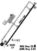
| Runways: | 05/23 |
| Longest Runway: | 05/23 is 5500 ft (1676 m) long |
| Runways with an Instrument Approach: | 05 |
KCPK Airport Runway Details
| Runway 05/23 | 5500 ft x 100 ft (1676 m x 30 m) | |
| Runway Length Source: | NGS as of 03/28/2009 | |
| Surface: | Asphalt - Good condition - Saw-cut or plastic grooved | |
| Runway Edge Lights: | High Intensity | |
Runway Weight Bearing Capacity (in thousands of pounds) |
||
| Single Wheel Landing Gear: | 30.0 | |
Runway 05 |
Runway 23 |
|
Elevation: |
16.5 | 18.4 |
Latitude: |
36-39-34.4787N | 36-40-17.9659N |
Longitude: |
076-19-34.6289W | 076-18-54.0907W |
|
Runway True Alignment: |
036 | 216 |
ILS Type: |
ILS/DME | |
Glide Path Angle: |
3.0 degrees | 3.0 degrees |
Traffic Pattern: |
Left | Right |
Runway Markings Type: |
Precision Instrument | Nonprecision Instrument |
Runway Markings Condition: |
Fair | Fair |
Object at End: |
TREE | TREE |
Object Height: |
59 | 89 |
Distance from End: |
1754 | 2205 |
Object Centerline Offset: |
720 ft. left of centerline | 166 ft. right of centerline |
Visual Glide Slope Indicators: |
4-Light PAPI On Left Side Of Runway | 4-Light PAPI On Left Side Of Runway |
Approach Light System: |
1,400 Foot Medium Intensity Approach Lighting System With Runway Alignment Indicator Lights | |
REIL: |
No | Yes |
Threshold Crossing Height: |
43 | 42 |
Services
Airframe Repair: |
None |
Powerplant Repair: |
None |
Bottled Oxygen: |
None |
Bulk Oxygen: |
None |
Fuel Available: |
100LL, Jet A-1+ |
Landing Fees: |
No |
Parking: |
Hangars and tiedowns available |
Maps & Diagrams
KCPK Sectional
Flight Planning
at skyvector.com
at skyvector.com