Location
Latitude: |
33-58-13.7000N (33.970472) |
Longitude: |
080-59-42.9000W (-80.99525) |
Elevation: |
193.4 feet MSL (59 m MSL) |
Magnetic Variation: |
7.7 W (as of April 2024 from WMM2020 model) |
Time Zone: |
UTC -5.0 (Standard Time) UTC -4.0 (Daylight Savings Time) |
From City: |
02 N.M. S of Columbia, South Carolina |
Found On: |
Charlotte Chart |
FAA Region: |
ASO |
Contacts
Manager: |
Publicly owned: |
| PETER CEVALLOS 1400 JIM HAMILTON BLVD COLUMBIA, SC 29205 803-771-7915 |
COUNTY OF RICHLAND PO BOX 192 COLUMBIA, SC 29202 803-748-4616 |
Operations
Airport Status: |
Operational |
Facility Use: |
Public |
Type: |
Airport |
Activation Date: |
08/1950 |
Control tower: |
No |
Attendance (Months/Days/Hours): |
Months/Days/Hours ALL/ALL/0600-2200 |
Boundary ARTCC: |
ZJX (Jacksonville) |
Responsible ARTCC: |
ZJX (Jacksonville) |
Lighting Schedule: |
SEE RMK |
Segmented Circle Indicator: |
Yes |
Traffic Pattern Altitude (MSL): |
1193 feet (364 m) |
NOTAMs Facility: |
CUB |
NOTAM-D Service: |
Yes |
International Airport of Entry: |
No |
Customs Landing Rights: |
No |
Military Landing Rights: |
Yes |
Civil/Military Joint Use: |
No |
Based Aircraft
| Single Engine: | 93 |
| Multi Engine: | 6 |
| Jet Engine: | 1 |
| GA Helicopters: | 3 |
| Gliders: | 1 |
Annual Operations (as of 08/21/2023)
| Total Operations: | 25000 | |
| Air Taxi: | 3652 | 14.6% |
| GA Local: | 12522 | 50.1% |
| GA Itinerant: | 7826 | 31.3% |
| Military Aircraft: | 1000 | 4.0% |
Communications
| CTAF: | 123.075 |
| Unicom: | 123.075 |
| Clearance Del.: | 124.4 124.4 124.4 |
| Approach: | COLUMBIA |
| Departure: | COLUMBIA |
| ASOS: | 118.675 (803-929-0665) |
Fixed Based Operators (FBOs) & Fuel
(Click on a business for detail)
Please help us keep this information up to date. This is a FREE SERVICE just like everything else on Airport Guide! If you see that a business needs to be added, modified, or deleted please fill out our Update Form.
To add, modify, or delete a business click here.
Please help us keep this information up to date. This is a FREE SERVICE just like everything else on Airport Guide! If you see that a business needs to be added, modified, or deleted please fill out our Update Form.
Area Code: 803 |
| Business Name | Frequency | Phone | Fuel Grade |
|---|---|---|---|
| Midlands Aviation Corporation
Update FBO info |
Unicom 122.8 | 771-7915 | 100LL, Jet A |
Flight Service Stations
| Primary | Alternate | |
| FSS on Field: | N | |
| FSS Name (ID): | Anderson(AND) | |
| Frequency: | ||
| Toll Free Phone: | 1-800-WX-BRIEF |
Instrument Procedures / Charts
FAA Terminal Procedures valid from 0901Z 03/21/24 to 0901Z 04/18/24.
There are various types of charts available for an airport. They are listed in the Page Type column. Here is a legend for those types:
APD - Airport Diagram
DP - Departure Procedure Charts
HOT - Hot Spots
IAP - Instrument Approach Procedure Charts
MIN - Minimums
STAR - Standard Terminal Arrival Charts
| Page Type | Page Name | Volume | Action Since Last Cycle |
|---|---|---|---|
| IAP | LOC RWY 31 | SE-2 | |
| IAP | RNAV (GPS) RWY 13 | SE-2 | |
| IAP | RNAV (GPS) RWY 31 | SE-2 | |
| MIN | TAKEOFF MINIMUMS | SE-2 |
Terminal Procedures are only available for airports in several countries with more being added all the time. If you are looking for a specific country's charts, please send an email to support(at)airportguide.com stating the country name. This will be used to prioritize the implementation.
Navigation Aids (Navaids) near CUB
| Dist (NM) | ID | Morse Code | Name | Type | Freq | True Hdg | Mag Hdg |
|---|---|---|---|---|---|---|---|
| 7.4 | CAE | _ . _ . . _ . | Columbia | VORTAC | 114.70 | 203 | 211 |
| 10.0 | MMT | _ _ _ _ _ | Mc Entire | VORTAC | 113.20 | 106 | 114 |
| 12.4 | CA | _ . _ . . _ | Murry | NDB | 362 | 269 | 277 |
| 21.4 | FDW | . . _ . _ . . . _ _ | Winnsboro | NDB | 414 | 344 | 352 |
| 26.3 | SSC | . . . . . . _ . _ . | Shaw | TACAN | 110.10 | 88 | 96 |
| 31.6 | EDS | . _ . . . . . | Edisto | VOR-DME | 111.40 | 167 | 175 |
| 31.6 | SMS | . . . _ _ . . . | Sumter | NDB | 252 | 87 | 95 |
| 37.8 | EOE | . _ _ _ . | Enoree | NDB | 278 | 302 | 310 |
| 39.0 | AIK | . _ . . _ . _ | Aiken | NDB | 347 | 240 | 248 |
| 40.4 | VAN | . . . _ . _ _ . | Vance | VORTAC | 110.40 | 137 | 145 |
| 45.6 | MNI | _ _ _ . . . | Manning | NDB | 381 | 120 | 128 |
| 45.6 | LKR | . _ . . _ . _ . _ . | Lancaster | NDB | 400 | 8 | 16 |
| 50.0 | DCM | _ . . _ . _ . _ _ | Chester | NDB | 220 | 348 | 356 |
| 50.7 | HVS | . . . . . . . _ . . . | Hartsville | NDB | 341 | 58 | 66 |
| 53.5 | UOT | . . _ _ _ _ _ | Union County | NDB | 326 | 323 | 331 |
| 54.2 | CTF | _ . _ . _ . . _ . | Chesterfield | VOR-DME | 114.55 | 40 | 48 |
| 55.3 | UZ | . . _ _ _ . . | Rally | NDB | 227 | 355 | 363 |
| 56.7 | PYG | . _ _ . _ . _ _ _ _ . | Pageland | NDB | 270 | 34 | 42 |
| 56.9 | GIW | _ _ . . . . _ _ | Coronaca | NDB | 239 | 287 | 294 |
| 58.1 | FL | . . _ . . _ . . | Alcot | NDB | 335 | 77 | 85 |
Nearby Airports with Fuel
Notices to Airmen (NOTAMS)
Remarks
| A110-1 | RR SWITCHING YARD PARALLEL TO RY 13/31. |
| A110-3 | AVOID NOISE SENSITIVE AREA NORTH OF ARPT BLO 1500 FT. |
| A110-4 | NO NORTHBOUND DEP TURNS EITHER RY BLO 1500 FT. |
| A110-6 | RY TO TWY SEPARATION IS 206 FT. THE SEPARATION DESIGN CRITERION IS NOT FULLY MET FOR ACFT 12,500 LBS AND LARGER |
| A110-7 | DUE TO PROXIMITY AND RY ALIGNMENT, AIRCREWS HAVE MISTAKEN CAE (RY 11/29) FOR CUB (RY 13/31) WHICH IS 6 MILES SW. |
| A110-8 | FOR CD CTC COLUMBIA APCH AT 803-822-5242 OR 803-822-5040. |
| A14 | FBO EAGLE AVIATION 803-771-7915. |
| A17 | FOR SERVICE AFTER HRS CALL 803-771-7915. |
| A43-13 | PAPI RWY 13 UNUSBL BYD 8 DEG RT. |
| A52-13 | RY 13 71 FT TREE 148 FT LEFT OF CNTRLN & 1096 FT FROM THLD, 40 FT POWER LINES 180 FT RIGHT OF CNTRLN & 958 FT FROM THLD, 30 FT BLDG 140 FT RIGHT & 900 FT FM THLD, 27 FT BLDG 653 FT FROM THLD & 172 FT LEFT. |
| A58-31 | RY 31, 18 FTTREES, 160 FT FM THLD 56 FT LEFT OF CENTERLINE. |
| A60-13 | 400 FT STWY NW END OF RY. |
| A70-FUEL-10 | 0LL CONTRACT FUEL FOR MILITARY. |
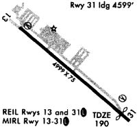
| A81-APT | ACTVT MIRL RY 13/31 AND REILS RYS 13 & 31 - CTAF. |
| E111 | EXISTED PRIOR TO 1958. |
| E147 | TPA: 807 FT AGL / 1000 FT MSL. |
Runways
Runway Summary
| Runways: | 13/31 |
| Longest Runway: | 13/31 is 5011 ft (1527 m) long |
| Runways with an Instrument Approach: | 31 |
CUB Airport Runway Details
| Runway 13/31 | 5011 ft x 75 ft (1527 m x 23 m) | |
| Runway Length Source: | 3RD PARTY SURVEY as of 03/17/2008 | |
| Surface: | Asphalt - Fair condition - No special surface treatment | |
| Runway Pavement Class: | 15 /F/B/X/T | |
| Runway Edge Lights: | Medium Intensity | |
Runway Weight Bearing Capacity (in thousands of pounds) |
||
| Single Wheel Landing Gear: | 44.5 | |
| Dual Wheel Landing Gear: | 66.0 | |
Runway 13 |
Runway 31 |
|
Elevation: |
193.4 | 182.4 |
Latitude: |
33-58-28.0426N | 33-57-59.3059N |
Longitude: |
081-00-07.1733W | 080-59-18.6767W |
|
Runway True Alignment: |
125 | 305 |
ILS Type: |
LOC/DME | |
Glide Path Angle: |
4.0 degrees | 3.0 degrees |
Traffic Pattern: |
Right | |
Runway Markings Type: |
Nonprecision Instrument | Nonprecision Instrument |
Runway Markings Condition: |
Good | Good |
Object at End: |
TREE | TREE |
Object Height: |
77 | 64 |
Distance from End: |
1096 | 1053 |
Object Centerline Offset: |
148 ft. left of centerline | 353 ft. right of centerline |
Visual Glide Slope Indicators: |
2-Light PAPI On Left Side Of Runway | 2-Light PAPI On Right Side Of Runway |
REIL: |
Yes | Yes |
Threshold Crossing Height: |
30 | 20 |
Threshold Elevation: |
185.6 | |
Displaced Threshold: |
391 | |
Threshold Latitude: |
33-58-01.5493N | |
Threshold Longitude: |
080-59-22.4620W | |
Declared Distances |
||
Take Off Run Avbl. (TORA): |
4999 | 4999 |
Take Off Distance Avbl. (TODA): |
4999 | 4999 |
Actual Stop Dist. Avbl. (ASDA): |
4999 | 4999 |
Landing Dist. Avbl. (LDA): |
4999 | 4599 |
Services
Airframe Repair: |
Major |
Powerplant Repair: |
Major |
Bottled Oxygen: |
High Pressure / Low Pressure |
Bulk Oxygen: |
High Pressure / Low Pressure |
Fuel Available: |
100LL, Jet A-1+ |
Landing Fees: |
No |
Parking: |
Hangars and tiedowns available |
Maps & Diagrams
CUB Sectional
Flight Planning
at skyvector.com
at skyvector.com