Location
Latitude: |
44-31-09.4250N (44.519285) |
Longitude: |
121-19-14.1610W (-121.3206) |
Elevation: |
2695.0 feet MSL (821 m MSL) |
Magnetic Variation: |
14.3 E (as of May 2024 from WMM2020 model) |
Time Zone: |
UTC -8.0 (Standard Time) UTC -7.0 (Daylight Savings Time) |
From City: |
06 N.M. W of Culver, Oregon |
Found On: |
Seattle Chart |
FAA Region: |
ANM |
Contacts
Manager: |
Privately owned: |
| ROY ECKELMAN (541) 815-3707 |
LAKE BILLY CHINOOK AIRPORT DEV CORP 8205 SW AIRPARK DR CULVER, OR 97734 503-550-2400 |
Operations
Airport Status: |
Operational |
Facility Use: |
Public |
Type: |
Airport |
Activation Date: |
11/1969 |
Control tower: |
No |
Attendance (Months/Days/Hours): |
Months/Days/Hours Unattended |
Boundary ARTCC: |
ZSE (Seattle) |
Responsible ARTCC: |
ZSE (Seattle) |
Segmented Circle Indicator: |
No |
Traffic Pattern Altitude (MSL): |
3695 feet (1126 m) |
NOTAMs Facility: |
MMV |
NOTAM-D Service: |
Yes |
International Airport of Entry: |
No |
Customs Landing Rights: |
No |
Based Aircraft
| Single Engine: | 9 |
| Multi Engine: | 1 |
Annual Operations (as of 08/27/2019)
| Total Operations: | 560 | |
| GA Local: | 500 | 89.3% |
| GA Itinerant: | 60 | 10.7% |
Communications
| CTAF: | 122.900 |
Fixed Based Operators (FBOs) & Fuel
(Click on a business for detail)
Please help us keep this information up to date. This is a FREE SERVICE just like everything else on Airport Guide! If you see that a business needs to be added, modified, or deleted please fill out our Update Form.
To add, modify, or delete a business click here.
Please help us keep this information up to date. This is a FREE SERVICE just like everything else on Airport Guide! If you see that a business needs to be added, modified, or deleted please fill out our Update Form.
Area Code: 503 |
| Business Name | Frequency | Phone | Fuel Grade |
|---|
Flight Service Stations
| Primary | Alternate | |
| FSS on Field: | N | |
| FSS Name (ID): | Mc Minnville(MMV) | |
| Frequency: | ||
| Toll Free Phone: | 1-800-WX-BRIEF |
Instrument Procedures / Charts
Terminal Procedures are only available for airports in several countries with more being added all the time. If you are looking for a specific country's charts, please send an email to support(at)airportguide.com stating the country name. This will be used to prioritize the implementation.
Navigation Aids (Navaids) near 5S5
| Dist (NM) | ID | Morse Code | Name | Type | Freq | True Hdg | Mag Hdg |
|---|---|---|---|---|---|---|---|
| 16.0 | DSD | _ . . . . . _ . . | Deschutes | VORTAC | 117.60 | 177 | 163 |
| 18.1 | RD | . _ . _ . . | Bodey | NDB | 411 | 134 | 120 |
| 69.2 | IMB | . . _ _ _ . . . | Kimberly | VOR-DME | 115.60 | 83 | 69 |
| 72.3 | LTJ | . _ . . _ . _ _ _ | Klickitat | VOR-DME | 112.30 | 7 | 353 |
| 72.3 | SL | . . . . _ . . | Turno | NDB | 266 | 286 | 272 |
| 78.1 | LBH | . _ . . _ . . . . . . . | Laker | NDB | 332 | 322 | 307 |
| 83.5 | EU | . . . _ | Frakk | NDB | 260 | 257 | 243 |
| 83.5 | LWG | . _ . . . _ _ _ _ . | Lewisburg | NDB | 225 | 274 | 260 |
| 84.3 | CBU | _ . _ . _ . . . . . _ | Columbia | TACAN | 109.20 | 320 | 305 |
| 84.4 | PDX | . _ _ . _ . . _ . . _ | Portland | VOR-DME | 111.80 | 320 | 305 |
| 84.4 | CVO | _ . _ . . . . _ _ _ _ | Corvallis | VOR-DME | 115.40 | 269 | 255 |
| 84.5 | PDX | . _ _ . _ . . _ . . _ | Portland | VOT | 111.00 | 320 | 305 |
| 85.1 | EUG | . . . _ _ _ . | Eugene | VORTAC | 112.90 | 254 | 240 |
| 86.4 | UBG | . . _ _ . . . _ _ . | Newberg | VOR-DME | 117.40 | 305 | 290 |
| 91.3 | BTG | _ . . . _ _ _ . | Battle Ground | VORTAC | 116.60 | 324 | 309 |
| 92.3 | HIO | . . . . . . _ _ _ | Hillsboro | VOT | 115.20 | 312 | 297 |
| 98.9 | PND | . _ _ . _ . _ . . | Banks | NDB | 356 | 312 | 297 |
Nearby Airports with Fuel
Notices to Airmen (NOTAMS)
Remarks
| A110-1 | ANIMALS ON & INVOF ARPT. |
| A110-2 | RY 16/34 RESTRICTED RY SIGHT DISTANCE. |
| A110-3 | GRASS AREA S. OF RY NOT FOR ACFT OPNS. |
| A110-4 | FOR CD CTC SEATTLE ARTCC AT 253-351-3694. |
| A33-16/34 | LOOSE GRVL ON SFC AT VARIOUS LOCATIONS ALG FULL LEN OF RWY. |
| A42-16 | RY 16 NSTD DSPLCD THLD MKGS; RY 16/34 NSTD RY MKGS NO NUMBERS OR CENTERLINE. |
| A57-16 | RY 16 APCH RATIO 25:1 TO DSPLCD THLD. |
| A58-16 | +3 ROCK BERM AT 0-30 FT FM RWY END & 60-85 FT L OF CNTRLN. 18 FT ROAD AT 65 FT XNG CNTRLN. +20 FT TREES AT 130-200 FT FM RWY END & 80-125 FT L & R OF CNTRLN. |
| A82 | FREQ: 122.900 |
Runways
Runway Summary
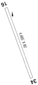
| Runways: | 16/34 |
| Longest Runway: | 16/34 is 2500 ft (762 m) long |
| Runways with an Instrument Approach: |
5S5 Airport Runway Details
| Runway 16/34 | 2500 ft x 32 ft (762 m x 10 m) | |
| Surface: | Asphalt - Fair condition - No special surface treatment | |
Runway 16 |
Runway 34 |
|
Glide Path Angle: |
0.0 degrees | 0.0 degrees |
Traffic Pattern: |
Left | Left |
Runway Markings Type: |
Nonstandard (other than numbers only) | Nonstandard (other than numbers only) |
Object at End: |
TREES | TREES |
Object Height: |
28 | 30 |
Distance from End: |
329 | 325 |
Object Centerline Offset: |
60 ft. left and right of centerline | 75 ft. left and right of centerline |
Displaced Threshold: |
660 |
Services
Airframe Repair: |
Major |
Powerplant Repair: |
Major |
Bottled Oxygen: |
High Pressure |
Bulk Oxygen: |
High Pressure / Low Pressure |
Fuel Available: |
100LL, Jet A |
Landing Fees: |
No |
Parking: |
Hangars and tiedowns available |
Maps & Diagrams
5S5 Sectional
Flight Planning
at skyvector.com
at skyvector.com