Location
Latitude: |
46-29-31.2760N (46.492021) |
Longitude: |
116-16-31.4380W (-116.275399) |
Elevation: |
1004.7 feet MSL (306 m MSL) |
Magnetic Variation: |
13.5 E (as of April 2024 from WMM2020 model) |
Time Zone: |
UTC -8.0 (Standard Time) UTC -7.0 (Daylight Savings Time) |
From City: |
01 N.M. NW of Orofino, Idaho |
Found On: |
Great Falls Chart |
FAA Region: |
ANM |
Contacts
Manager: |
Publicly owned: |
| RYAN SMATHERS 217 FIRST ST OROFINO, ID 83544 208-476-4725 |
CITY OF OROFINO P. O. BOX 312 OROFINO, ID 83544 208-476-4725 |
Operations
Airport Status: |
Operational |
Facility Use: |
Public |
Type: |
Airport |
Activation Date: |
04/1940 |
Control tower: |
No |
Attendance (Months/Days/Hours): |
Months/Days/Hours Unattended |
Boundary ARTCC: |
ZSE (Seattle) |
Responsible ARTCC: |
ZSE (Seattle) |
Lighting Schedule: |
SEE RMK |
Segmented Circle Indicator: |
No |
Traffic Pattern Altitude (MSL): |
2005 feet (611 m) |
NOTAMs Facility: |
BOI |
NOTAM-D Service: |
Yes |
International Airport of Entry: |
No |
Customs Landing Rights: |
No |
Military Landing Rights: |
Yes |
Civil/Military Joint Use: |
No |
Based Aircraft
| Single Engine: | 13 |
| GA Helicopters: | 3 |
Annual Operations (as of 09/30/2021)
| Total Operations: | 4100 | |
| GA Local: | 1100 | 26.8% |
| GA Itinerant: | 3000 | 73.2% |
Communications
| CTAF: | 122.800 |
| Unicom: | 122.800 |
Fixed Based Operators (FBOs) & Fuel
(Click on a business for detail)
Please help us keep this information up to date. This is a FREE SERVICE just like everything else on Airport Guide! If you see that a business needs to be added, modified, or deleted please fill out our Update Form.
To add, modify, or delete a business click here.
Please help us keep this information up to date. This is a FREE SERVICE just like everything else on Airport Guide! If you see that a business needs to be added, modified, or deleted please fill out our Update Form.
Area Code: 208 |
| Business Name | Frequency | Phone | Fuel Grade |
|---|---|---|---|
| Orofino Aviation
Update FBO info |
Unicom 122.8 | 476-4714 | 100LL |
Flight Service Stations
| Primary | Alternate | |
| FSS on Field: | N | |
| FSS Name (ID): | Boise(BOI) | |
| Frequency: | ||
| Toll Free Phone: | 1-800-WX-BRIEF |
Instrument Procedures / Charts
Terminal Procedures are only available for airports in several countries with more being added all the time. If you are looking for a specific country's charts, please send an email to support(at)airportguide.com stating the country name. This will be used to prioritize the implementation.
Navigation Aids (Navaids) near S68
| Dist (NM) | ID | Morse Code | Name | Type | Freq | True Hdg | Mag Hdg |
|---|---|---|---|---|---|---|---|
| 25.4 | MQG | _ _ _ _ . _ _ _ . | Nez Perce | VOR-DME | 114.45 | 255 | 241 |
| 26.8 | IDQ | . . _ . . _ _ . _ | Cottonwood | DME | 115.65 | 197 | 184 |
| 40.6 | PUW | . _ _ . . . _ . _ _ | Pullman | VOR-DME | 117.15 | 285 | 271 |
| 63.4 | MLP | _ _ . _ . . . _ _ . | Mullan Pass | VOR-DME | 117.80 | 23 | 10 |
| 80.1 | COE | _ . _ . _ _ _ . | Coeur D'alene | VOR-DME | 108.80 | 344 | 330 |
| 80.1 | LEN | . _ . . . _ . | Post Falls | NDB | 347 | 339 | 325 |
| 81.8 | AL | . _ . _ . . | Trina | NDB | 353 | 257 | 243 |
| 83.1 | SFF | . . . . . _ . . . _ . | Spokane/Felts Field | VOT | 114.00 | 329 | 315 |
| 84.6 | GEG | _ _ . . _ _ . | Spokane Intl | VOT | 109.60 | 323 | 309 |
| 84.8 | GEG | _ _ . . _ _ . | Spokane | VORTAC | 115.50 | 319 | 305 |
| 85.2 | INE | . . _ . . | Konna | NDB | 521 | 64 | 51 |
| 85.8 | CRK | _ . _ . . _ . _ . _ | Canyon | NDB | 388 | 326 | 312 |
| 87.1 | ALW | . _ . _ . . . _ _ | Walla Walla | VOR-DME | 116.40 | 254 | 240 |
| 87.8 | SKA | . . . _ . _ . _ | Fairchild | TACAN | 111.40 | 320 | 306 |
| 93.6 | MSO | _ _ . . . _ _ _ | Missoula | VOR-DME | 112.80 | 73 | 60 |
| 98.6 | LGD | . _ . . _ _ . _ . . | La Grande | NDB | 296 | 226 | 212 |
Nearby Airports with Fuel
Notices to Airmen (NOTAMS)
Remarks
| A110-1 | HIGH TERRAIN IN ALL QUADS AROUND ARPT. |
| A110-2 | TWO 1968 FT MSL (250 FT AGL) RADIO TWRS LCTD APRXLY 1 MI E OF RWY 26 300 FT LEFT. |
| A110-3 | BE ALERT DURING NIGHT OPS DUE TO TERRAIN. |
| A110-4 | FOR CD CTC SEATTLE ARTCC AT 253-351-3694. |
| A110-5 | FUEL AVBL 24/7 WITH CREDIT CARD. |
| A58-26 | +13 FT ROAD AT 0 FT 110 FT R OF CNTRLN. |
| A81-APT | ACTVT RWY 08/26 MIRL - CTAF. |
Runways
Runway Summary
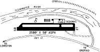
| Runways: | 08/26 |
| Longest Runway: | 08/26 is 2520 ft (768 m) long |
| Runways with an Instrument Approach: |
S68 Airport Runway Details
| Runway 08/26 | 2520 ft x 60 ft (768 m x 18 m) | |
| Runway Length Source: | 3RD PARTY SURVEY as of 01/16/2019 | |
| Surface: | Asphalt - Good condition - No special surface treatment | |
| Runway Edge Lights: | Medium Intensity | |
Runway Weight Bearing Capacity (in thousands of pounds) |
||
| Single Wheel Landing Gear: | 17.0 | |
Runway 08 |
Runway 26 |
|
Elevation: |
1000.0 | 1004.7 |
Latitude: |
46-29-36.2558N | 46-29-26.2956N |
Longitude: |
116-16-47.9388W | 116-16-14.9373W |
Glide Path Angle: |
0.0 degrees | 0.0 degrees |
Traffic Pattern: |
Right | Left |
Runway Markings Type: |
Basic | Basic |
Runway Markings Condition: |
Good | Good |
Object at End: |
TREE | TREE |
Object Height: |
85 | 65 |
Distance from End: |
320 | 1125 |
Object Centerline Offset: |
150 ft. right of centerline | 175 ft. left of centerline |
Threshold Elevation: |
1000.2 | |
Displaced Threshold: |
100 | |
Threshold Latitude: |
46-29-35.8593N | |
Threshold Longitude: |
116-16-46.6317W |
Services
Airframe Repair: |
Major |
Powerplant Repair: |
Major |
Bottled Oxygen: |
Low Pressure |
Fuel Available: |
100LL |
Landing Fees: |
No |
Parking: |
Tiedowns available |
Maps & Diagrams
S68 Sectional
Flight Planning
at skyvector.com
at skyvector.com